Friday Forecast calls for more rain and thunderstorms
 A pedestrians shield themselves from rain and wind during a rainfall warning in Halifax on Thursday, January 26, 2023. (THE CANADIAN PRESS/Darren Calabrese)
In an all too familiar sounding forecast, the Maritimes can expect rain along with a risk of thunderstorms on Friday.
An area of low pressure will move towards the Maritimes out of Quebec while a second low pressure moves northward from the eastern United States. While they won’t meet up directly over the Maritimes, they will get close enough to bring in a round of rain with embedded thunderstorms.
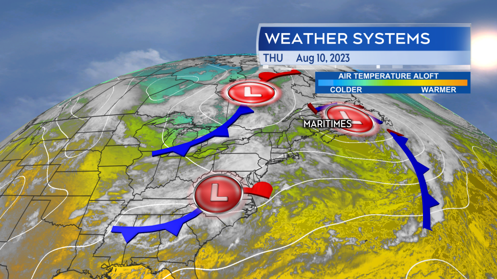 Two low pressure systems, one to our west and one to our south, approach the Maritimes Friday bringing rain and a risk of thunderstorms. (CTV/Kalin Mitchell) The rain and thunderstorms are expected to arrive in western New Brunswick and southwestern Nova Scotia just before sunrise on Friday. The rain and thunderstorms then move west-to-east across the Maritimes Friday morning through the afternoon.
Cape Breton won’t see the rain until late afternoon, but it won’t clear until later Friday evening. Behind the rain there is a chance of showers with a risk of thunderstorms that extends into Friday evening.
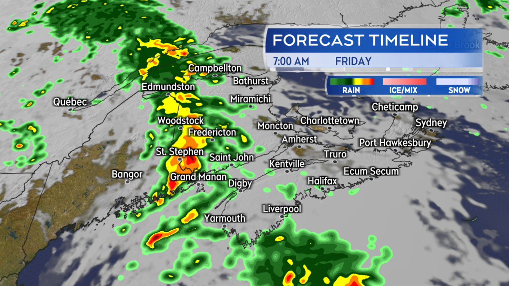 A band of rain and thunderstorms arrives into western New Brunswick and southwestern Nova Scotia early Friday morning. (CTV/Kalin Mitchell)
The speed of the system should limit most rainfall totals to 10 to 30 mm. Thunderstorms within the rain producing totals of 40 to 80 mm. The higher rain amounts and downpours associated with the thunderstorms increasing the risk of reduced visibility on roads, hydroplaning conditions, and ponding water in low lying areas.
There are a few areas that have a higher risk of those thunderstorms. That includes areas of New Brunswick and Nova Scotia around the Bay of Fundy. Environment Canada has issued a Special Weather Statement for those areas cautioning on the higher thunderstorm potential.
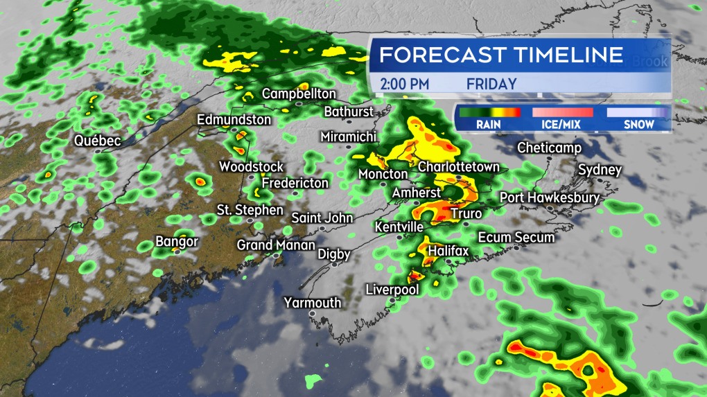 The rain and thunderstorms moves quickly west-to-east across the Maritimes Friday morning into afternoon. (CTV/Kalin Mitchell) Gusty winds will accompany the passing rain. At first coming from the south the winds will become westerly as the rain passes. Gusts of 30 to 60 km/h are expected.


CTVNews.ca Top Stories

BREAKING
BREAKING Foreign meddling 'did not affect' overall federal election results: inquiry report
Foreign interference by China did not affect the overall results of the 2019 and 2021 general elections won by Justin Trudeau's Liberals, a federal commission of inquiry has found.
BREAKING
BREAKING Police make arrests in killing of B.C. Sikh activist, source confirms
Police have made arrests in the killing of B.C. Sikh activist Hardeep Singh Nijjar, a senior government source has confirmed to CTV News.
WATCH LIVE
WATCH LIVE Funeral today for broadcasting legend and voice of 'Hockey Night in Canada' Bob Cole
A funeral is being held today for hockey broadcasting legend Bob Cole in his hometown of St. John's, N.L.
Magnitude 4.8 earthquake recorded west of Vancouver Island
A 4.8-magnitude earthquake was reported west of Vancouver Island Thursday evening.
TD worst-case scenario more likely after drug money laundering allegations: analyst
TD Bank Group could be hit with more severe penalties than previously expected, says a banking analyst after a report that the investigation it faces in the U.S. is tied to laundering illicit fentanyl profits.
How falling for a stranger she met on a beach led this woman to ditch the U.S. for the French Riviera
Niki Benjamin, from the U.S., had travelled to a paradise island to do some soul searching, and her life ended up going in a very different direction when her dog ran up to a stranger.
Biscuits with possible plastic pieces, metal found in ground pork: Here are the recalls for this week
Here are the latest recalls Canadians should watch out for, according to Health Canada and the Canadian Food Inspection Agency.
Britney Spears 'home and safe' after paramedics responded to an incident at the Chateau Marmont, source tells CNN
A source close to singer Britney Spears tells CNN that the pop star is 'home and safe' after she had a 'major fight' with her boyfriend on Wednesday night at the Chateau Marmont in West Hollywood.
Supreme Court orders new trial for B.C. francophone who was not given French option
The Supreme Court is ordering a new trial for a francophone man in British Columbia who says he was not informed of his right to have a trial in the official language of his choice.
Shopping Trends
The Shopping Trends team is independent of the journalists at CTV News. We may earn a commission when you use our links to shop. Read about us.


Toronto
-

Toronto mayor responds to criticism on city's request to decriminalize certain drugs
Toronto Mayor Olivia Chow is responding to criticism over Toronto‘s efforts to decriminalize drugs in the wake of the opioid crisis, saying it misses a much more urgent need.
-
Pro-Palestinian encampment remains at University of Toronto despite safety concerns
Supporters are dropping off water and other supplies at an encampment set up by pro-Palestinian student protesters at the University of Toronto's downtown campus as the demonstration enters its second day.
-
Did Toronto break a rain record in April? It depends where you're looking
If you thought this past April felt especially rainy in Toronto, you’re not wrong. Environment Canada says 135.5 millimetres of rain, mixed with snow, fell at Pearson International Airport last month, which beats the previous record of 133.8 mm set in April of 1992.
Calgary
-
Calgary halal stores closed by AHS can now reopen
Alberta Health Services (AHS) says all of the uninspected halal meat found at several Calgary businesses has been destroyed and the affected facilities are cleared to open.
-
Bridal shop serving Calgary 54 years ends tradition, unveils new plan
As wedding dress styles change through the decades, one Calgary shop has remained a constant option for local brides for more than half a century.
-
Spring cleaning: Calgarians rolling up sleeves for annual litter pickup
Thousands of Calgarians are set to lend a hand in the city’s annual effort on Friday.
Edmonton
-
 LIVE @ 11
LIVE @ 11 Police to provide update on 2009 homicide of Michelle Hadwen
The Edmonton Police Service will give an update on a historical homicide on Friday morning.
-
WEATHER
WEATHER Josh Classen's forecast: Sunny end to a wet week
Light wind, some sun and a warming trend for the Edmonton area today and Saturday.
-
1 killed in crash on Highway 44 near Chisholm Thursday
An Edmonton man was killed in a crash near Chisholm Thursday afternoon.
Montreal
-

Judge worries amendment to Quebec language law will cause 'undue delays' for English trials
A Quebec judge overseeing the trial of a person accused of killing a cyclist with their car has raised concerns that an amendment to the province's language charter could cause 'undue delays' for trials held in English.
-
Montreal baker reinvents her craft after Celiac disease diagnosis
Eight years ago, Lauren McGowan found out she had Celiac disease. As a baker, the Montrealer says the diagnosis didn't just change her life personally -- but also professionally.
-
Terrebonne man pocketed $150,000 from helping people get fake COVID-19 vaccine passports
A former worker at a COVID-19 vaccination centre pleaded guilty after he made $150,000 from helping hundreds of Quebecers obtain fake vaccination passports during the height of the pandemic.
Ottawa
-

Two Ontario nurses help deliver baby during a flight going to Dubai
Two registered nurses from Ottawa and Kingston have been an integral part in the delivery of a baby on board a flight heading to Dubai.
-
Sexual assault suspect sought by Ottawa police
The Ottawa Police Service is asking the public for help in identifying a suspect allegedly involved with a sexual assault that happened at a home on Albert Street two months ago.
-
Forcing public servants back to downtown Ottawa harms satellite communities: North Grenville mayor
The mayor of North Grenville, just south of Ottawa, says hybrid work has been a boon to her community, and a recent move by the federal government to force public servants back to downtown Ottawa office buildings is misguided.
London
-

Three people in hospital following crash east of London, Ont.
A two-vehicle crash involving a transport truck and a passenger vehicle closed Dundas Street, just west of Thamesford, late Thursday afternoon.
-
Fatal crash in South-West Oxford Township
Around 6:45 p.m. on Thursday, first responders were called to the scene near the intersection of Pigram Road and Salford Road in South-West Oxford Township.
-
Clean up outside derelict building doesn’t quell concerns about trespassing and fire risk
Despite a recent clean-up around the former St. Pierre Renovation Centre, concern persists about trespassing and the risk of fire at the former industrial building.
Barrie
-

30 firefighters battled the blaze of Bracebridge facility
On Thursday night, 30 firefighters battled a destructive fire that broke out in a facility in Bracebridge Ont.
-
Barrie's photo radar cameras are moving to new locations: Here's where
Barrie's photo radar cameras will relocate to new community safety zones this month to curb speeding on neighbourhood roads.
-
Barrie police arrest man after reports of possibly armed suspect making threats
Barrie officers made an arrest after receiving reports on Thursday afternoon that a possibly armed man made threatening gestures at a Dunlop Street East business owner.
Northern Ontario
-

New Hamburg, Ont. family can't get truck's faulty transmission fixed due to aftermarket attachment
A New Hamburg family is feeling deflated after buying a new Toyota hybrid truck.
-
'We have a bright future': Sudbury mayor gives second state of city address
Greater Sudbury Mayor Paul Lefebvre delivered his state of the city address at the Caruso Club on Thursday, his second since being elected in 2022.
-
Northern Ont. police forced into the river to save intoxicated swimmer
An intoxicated man wearing only his underwear and a lifejacket had to be pulled from the Thessalon River early Wednesday evening.
Kitchener
-
 BREAKING
BREAKING WRDSB to lay off 106 elementary school teachers
More than 100 teachers at the Waterloo Region District School Board (WRDSB) are learning they have been declared surplus will likely be out of a job as of Aug. 12.
-
Large barn fire in Elmira
Three Bridges Road is closed as emergency crews respond to what police say is a “large barn fire” in Elmira.
-
New Hamburg, Ont. family can't get truck's faulty transmission fixed due to aftermarket attachment
A New Hamburg family is feeling deflated after buying a new Toyota hybrid truck.
Windsor
-

Two people exchange gunfire in Leamington parking lot
Essex County OPP investigators are asking for help in identifying an individual involved in a shooting incident in a Leamington parking lot.
-
BREAKING
BREAKING Police make arrests in killing of B.C. Sikh activist, source confirms
Police have made arrests in the killing of B.C. Sikh activist Hardeep Singh Nijjar, a senior government source has confirmed to CTV News.
-
Highway 401 construction zone blitz leads to 76 charges
A joint traffic initiative in a construction zone on Highway 401 resulted in dozens of charges.
Winnipeg
-
 BREAKING
BREAKING Winnipeg judge rules trial of accused serial killer to start with jury
A judge has decided the trial of a man accused of killing four women in Winnipeg will still be heard by a jury.
-
'System failures': Starbucks to close its doors amid recent violence in Osborne Village
The long-standing Starbucks in Osborne Village is set to close its doors next week – it comes one day after a man was attacked next door.
-
Province announces millions in funding for social housing units
The Kinew government announced two, multi-million-dollar housing projects targeting Manitobans experiencing gender-based violence and homelessness.
Regina
-

Sask. Party votes down NDP motion to cut provincial gas tax
Saskatchewan motorists won’t be getting an immediate 15 cent per litre break at the pumps as an NDP motion to cut the provincial gas tax was voted down by the Sask. Party on Thursday.
-
Sask. set to gather to remember Riders legend Jim Hopson
Saskatchewan Roughriders past and present along with many friends, family and fans from around the CFL will gather in Regina Friday afternoon to remember the late Jim Hopson.
-
North Central Family Centre launches Hopes and Dreams campaign
The North Central Family Centre (NCFC) has launched a capital campaign to help aid in the completion of a major project they are in the midst of building.
Saskatoon
-

Deflated for now, Saskatoon's Golf Dome is about to get a makeover
A lesser known fixture of Saskatoon's skyline is coming down for repairs and renovations.
-
Company fined $260,000 for workplace injury in Saskatoon
Richelieu Hardware Canada Ltd. was fined a hefty $260,000 for a workplace safety violation leading to a serious worker injury.
-
'Healthy, happy calves': Cow gives birth to rare set of quadruplets in Saskatchewan
A Saskatchewan family won the bovine lottery after their cow gave birth to a rare set of quadruplets.
Vancouver
-
 BREAKING
BREAKING Police make arrests in killing of B.C. Sikh activist, source confirms
Police have made arrests in the killing of B.C. Sikh activist Hardeep Singh Nijjar, a senior government source has confirmed to CTV News.
-
Quebec man charged with 11 counts of fraud in B.C.'s Lower Mainland
A Quebec man is facing 11 counts of fraud connected to incidents across B.C.'s Lower Mainland, Surrey Mounties say.
-
Princess Anne to take part in B.C. ceremony bringing new ship into Pacific fleet
The first Arctic and Offshore Patrol Vessel for Canada's Pacific fleet will officially be commissioned in a ceremony featuring Princess Anne, the sister of King Charles.
Vancouver Island
-
BREAKING
BREAKING Police make arrests in killing of B.C. Sikh activist, source confirms
Police have made arrests in the killing of B.C. Sikh activist Hardeep Singh Nijjar, a senior government source has confirmed to CTV News.
-
Nanaimo family seeks transfer due to concerns about quality of care at long-term facility
A family claims it’s concerned for their loved one in a Nanaimo-based long-term care facility as they work with staff and Island Health to resolve some of their complaints.
-
Princess Anne to take part in B.C. ceremony bringing new ship into Pacific fleet
The first Arctic and Offshore Patrol Vessel for Canada's Pacific fleet will officially be commissioned in a ceremony featuring Princess Anne, the sister of King Charles.
Kelowna
-

B.C. breweries take home awards at World Beer Cup
Out of more than 9,000 entries from over 2,000 breweries in 50 countries, a handful of B.C. brews landed on the podium at the World Beer Cup this week.
-
B.C. man rescues starving dachshund trapped in carrier: BC SPCA
An emaciated dachshund is now recovering thanks to a Good Samaritan who found the pup near a biking trail in Kelowna, according to the BC SPCA.
-
Search crews called in after missing Kelowna senior's truck found
Search and rescue crews have been called in after a vehicle belonging to a missing senior was located near a rural intersection outside of Kelowna Tuesday.


