Pressure cooker: Heat warnings triggered in eastern and western Canada
High pressure turning up the heat
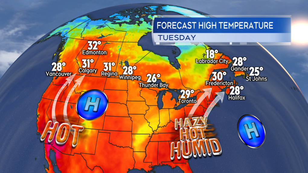
Dual, dominant areas of high pressure are contributing to the heat warnings in both eastern and western Canada.
In Atlantic Canada a combination of a ridge of high pressure built out of the eastern United States and a southerly flow are bringing in humid air and high temperatures for many communities. Temperatures are expected to reach the high-twenties and low-thirties. The humidex is making it feel into the mid-to-high 30’s. Heat warnings are in effect in Newfoundland and Labrador, New Brunswick, Nova Scotia, and Prince Edward Island.
In western Canada a high pressure system centred near Wyoming is helping to send temperatures soaring. The clockwise circulation around the high cycling in air from the hotter states such as California, Nevada, and Arizona. High temperature records fell by the dozen on Sunday for British Columbia, including at Ashcroft to the west of Kamloops which reported a high of 40.3 degrees. Southern and eastern areas of that province remain under Heat Warnings on Monday. Heat Warnings have also expanded across Alberta and into Saskatchewan as well as touching into the Northwest Territories.
 High pressure helping to pump hot, humid air into Atlantic Canada. In the west a similar situation with a ridge of high pressure building out of the northwestern US.
Mid-week cooling for the Maritimes
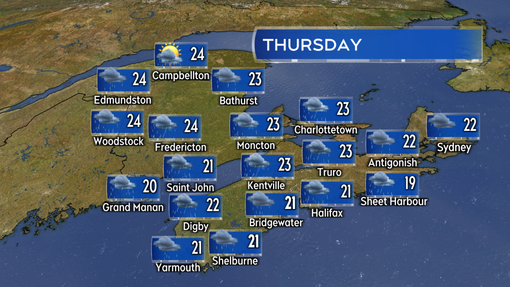
The heat is expected to last through Tuesday with changes arriving Wednesday into Thursday. A weather front from the west will increase cloudiness and return rain and showers to the region with temperatures coming down as a result. Despite the cooling humidity is expected to remain high for all three Maritimes provinces, especially with the contribute moisture from the rain and showers. Expect muggy conditions to continue into the upcoming weekend.
 Humidity remains high but temperatures cool Wednesday into Thursday for the Maritimes.
Remnants of Hurricane Beryl
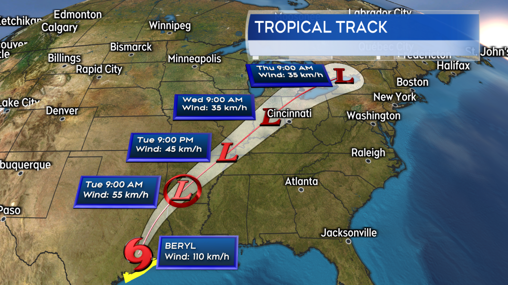
Beryl has come onshore in Texas as a category-one hurricane. The storm continues to poses risks associated with storm surge, rip tides, flash flooding, and high winds to that state.
Beryl is forecast to move from Texas into the US-Midwest by Wednesday. While weakening and becoming non-tropical along the route, remnants of Beryl is likely to get tied up into the front bringing the Maritimes rain this week. This increases the risk of downpours and thunderstorms within the rain expected.
 Beryl becomes a remnant weather system as it moves through the US this week. The leftover moisture from the system may bring a risk of downpours to parts of the Maritimes late Wednesday and Thursday.
At this time the area and period of time of greatest risk is southern New Brunswick and mainland Nova Scotia late Wednesday through Thursday. The stalling front acting like a highway to send the downpours along. With Beryl having to travel through the United States it is too early to look at possible rain totals for specific areas/communities at this time. Computer weather prediction models are indicating pockets of rain totals 60 to over 100 mm being possible though. A situation that will need to be watched moving later into the week.
CTVNews.ca Top Stories

Ottawa has sold its stake in Air Canada: sources
Two senior federal government sources have confirmed to CTV News that the federal government has sold its stake in Air Canada.
Premiers disagree on whether Canada should cut off energy supply to U.S. if Trump moves ahead with tariffs
Some of Canada's premiers appeared to disagree with Ontario Premier Doug Ford on his approach to retaliatory measures, less than a day after he threatened to cut off the province's energy supply to the U.S. if president-elect Donald Trump follows through on his threat of punishing tariffs.
'I recognize these footsteps': How Trump and 'coyote' smuggling changed life at the border
Bent signs bolted to the rail threaten fines and imprisonment should violators cross the boundary into the United States, a warning many people are choosing to ignore simply by walking around the barrier.
She took a DNA test for fun. Police used it to charge her grandmother with murder in a cold case
According to court documents, detectives reopened the cold case in 2017 and then worked with a forensics company to extract DNA from Baby Garnet's partial femur, before sending the results to Identifinders International.
McDonald's employee who called 911 in CEO's shooting is eligible for reward, but it will take time
More than 400 tips were called into the New York Police Department's Crime Stoppers tip line during the five-day search for a masked gunman who ambushed and fatally shot UnitedHealthcare CEO Brian Thompson last week.
Man who set fires inside Calgary's municipal building lost testicle during arrest: ASIRT
Two Calgary police officers have been cleared of any wrongdoing in an incident that saw a suspect lose a testicle after being shot with an anti-riot weapon.
Country star Morgan Wallen sentenced in chair-throwing case
Country music star Morgan Wallen on Thursday pleaded guilty to two misdemeanour counts of reckless endangerment for throwing a chair from the rooftop of a six-storey bar in Nashville and nearly hitting two police officers with it.
Danielle Smith announces new team to patrol Alberta-U.S. border
Premier Danielle Smith says her government will create a team of specially-trained sheriffs tasked with patrolling the Alberta-U.S. border.
Ho ho, oh no: Man sought by police goes down chimney and gets stuck
A Massachusetts man trying to escape from police shimmied down the chimney. And got stuck.


