Kalin's call: High winds, snow and rain on the way for the Maritimes
 Ice is shown on the branch of a tree following freezing rain and strong winds in Laval, Que., Tuesday, April 9, 2019. THE CANADIAN PRESS/Graham Hughes
Some areas are already into the start of the weather impacts that will be brought on by a combination of a cold front and a low-pressure system crossing the Maritimes late Thursday into Friday.
South and southwest winds are high and gusty and will continue to increase for southern areas of New Brunswick, Prince Edward Island, and Nova Scotia Thursday night, where wind warnings have been issued.
Those winds should reach a peak Friday morning with gusts climbing into a range of 80 to 110 km/h. As the cold front passes Friday morning and afternoon, the wind direction will switch to the northwest and the strength of the wind will diminish into Friday evening and night. There is a continued risk of power outages until that time.
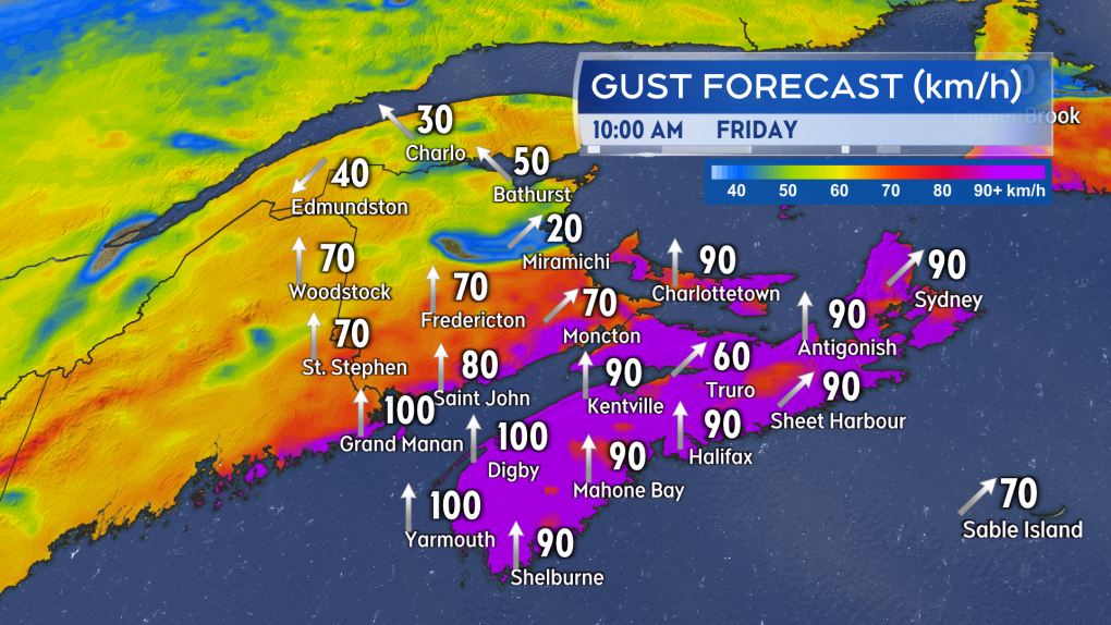 The southerly winds will reach a peak Friday morning for southern New Brunswick, Prince Edward Island and Nova Scotia.
The quick turn from southerly to northerly winds will bring a quick fall in temperatures back below freezing on Friday. That fall in temperatures is expected for New Brunswick Friday morning into early afternoon, and Friday afternoon into early evening for P.E.I. and Nova Scotia. In some cases, temperatures could fall from several degrees above zero to several degrees below in a matter of hours. Wet surfaces could quickly become icy.
A flash freeze warning has been issued for much of the Maritimes for Friday.
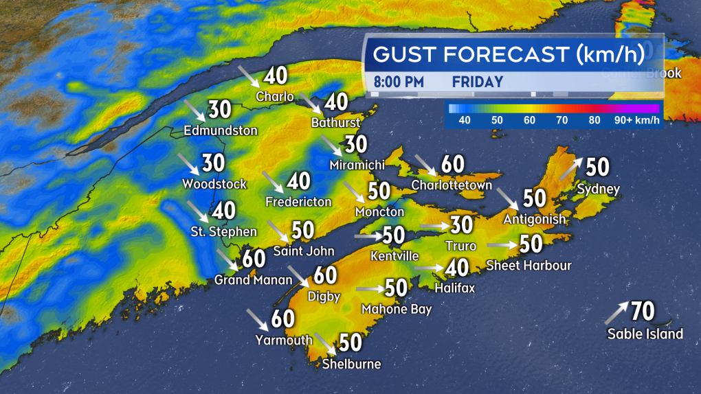 The wind direction changes to the northwest behind the passage of the front by Friday afternoon and evening. The northwest wind will bring a quick fall in temperature and a risk of flash freezing.
Northern areas of New Brunswick will get onto the colder side of the system first. That will happen Thursday night into early Friday morning. Heavy snow is expected for Madawaska and Restigouche counties with 15 to 25 centimetres of accumulation forecast. Snowfall warnings are in effect for these areas.
The remainder of northern New Brunswick may experience a prolonged period of freezing rain, ice pellets, and some snow Thursday night into Friday morning. Areas at risk of that period of icy weather have been placed under freezing rain warnings.
For the rest of the Maritimes, the most precipitation is expected to be in the form of rain. A general rain total of 20 to 60 millimetres is possible, with the Bay of Fundy coastline in New Brunswick and the southwest of Nova Scotia with the best chance of reaching the high end of the range.
There is a risk of localized flooding as the ground is frozen; drainage systems may be blocked, and melting snow will add to the on ground water. The most rain will fall for New Brunswick Thursday night and Friday morning. The most rain will fall for P.E.I. and Nova Scotia Friday morning and afternoon.
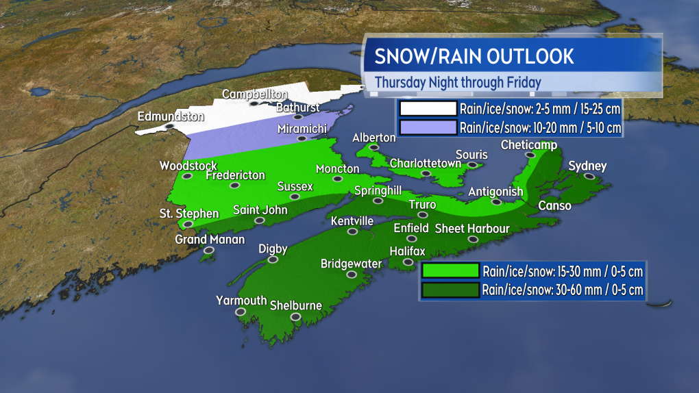 A mix of heavy snow and freezing rain is expected in northern areas of New Brunswick. Much of the rest of the region will see most of their precipitation in the form of rain.
CTV Atlantic's Chief Meteorologist Kalin Mitchell will have updates on CTV Atlantic News at Noon, 5, 6, and 11:30 p.m.


CTVNews.ca Top Stories

'Environmental racism': First Nations leaders claim cancer-causing contamination was covered up
The people of Fort Chipewyan believe the federal government believe the federal government knew its water was contaminated and hid the issue for years. Now the chief of the Athabasca Chipewyan First Nation is leading the call for immediate action.
Death toll from Hurricane Helene rises to 227 as grim task of recovering bodies continues
The death toll from Hurricane Helene inched up to 227 on Saturday as the grim task of recovering bodies continued more than a week after the monster storm ravaged the Southeast and killed people in six states.
Car flies into B.C. backyard, lands upside down
A driver suffered only minor injuries after going airborne in a residential neighbourhood in Maple Ridge, B.C., on Friday, the car eventually landing on its roof in someone’s backyard.
Donald Trump, Elon Musk attend rally at same Pennsylvania grounds where gunman tried to assassinate Trump
Donald Trump returned on Saturday to the Pennsylvania fairgrounds where he was nearly assassinated in July, holding a sprawling rally with thousands of supporters in a critical swing state Trump hopes to return to his column in November's election.
Tax rebate: Canadians with low to modest incomes to receive payment
Canadians who are eligible for a GST/HST tax credit can expect their final payment of the year on Friday.
'No one has $70,000 dollars lying around': Toronto condo owners facing massive special assessment
The owners of a North York condominium say they are facing a $70,000 special assessment to fix their building's parking garage. '$70,000 is a lot of money. It makes me very nervous and stressed out of nowhere for this huge debt to come in,' said Ligeng Guo.
Police ID mom, daughter killed in Old Montreal; video shows person break into building before fatal fire
Police released the identities of the mother and daughter who were killed after a fire tore through a 160-year-old building in Old Montreal on Friday.
Frequent drinking of fizzy beverages and fruit juice are linked to an increased risk of stroke: research
New data raises questions about the drinks people consume and the potential risks associated with them, according to researchers at Galway University in Ireland, in partnership with Hamilton’s McMaster University.
'I screamed in shock and horror': Family faces deadly Vancouver hit-and-run driver during sentencing
The sentencing of the man who pleaded guilty in the deadly hit-and-run in Kitsilano two years ago began on Friday.
Shopping Trends
The Shopping Trends team is independent of the journalists at CTV News. We may earn a commission when you use our links to shop. Read about us.


Toronto
-

Ontario Science Centre to open up temporary satellite locations months after sudden shutdown
The Ontario Science Centre is set to launch two temporary satellite locations in other parts of Toronto, which could let visitors access some of its interactive exhibits while a full interim location remains at least a year away, CTV News has learned.
-
Fans cheer Messi as Toronto FC concedes late goal to Miami and misses out on playoffs
Leo Campana's stoppage-time goal gave Inter Miami a 1-0 win and left Toronto FC's playoff hopes hanging by a thread Saturday.
-
Officer arrested after allegedly stealing alcohol from store: TPS
A Toronto police officer has been arrested after allegedly stealing three bottles of alcohol from a store.
Calgary
-

Serious crash impacts traffic on northbound Deerfoot Trail
Emergency crews are on scene of a multi-vehicle collision along northbound Deerfoot Trail near 17 Avenue Southeast.
-
Pro-Palestinian rally at Calgary City Hall ahead of first anniversary of October 7 Hamas attack on Israel
The first anniversary of the October Seventh Hamas attack on Israel is Monday and that prompted several hundred people to attend a pro-Palestinian rally Saturday afternoon at city hall.
-
Investigation underway into Friday night fatal collision in southeast Calgary
An investigation is underway into a Friday night collision in southeast Calgary that left one person dead.
Edmonton
-

Crash between motorcycle and van closes Highway 39 near Warburg
Highway 39 near Warburg was closed Saturday after a serious crash involving a motorcycle and a van.
-
'We're losing billions of birds': Backyard risks to Alberta's birds and how you can help make fall migration a successful one
An estimated four billion birds will navigate man-made environments as they travel south from North America during fall migration. Tens of million of them will die en route due to human-created hazards.
-
'They make me dig deep': 63-year-old CFR champion looks for 2nd win in Saturday finals
Barrel racer pro Lynette Brodoway has been riding in rodeos since before some of her competitors were born.
Montreal
-

Police ID mom, daughter killed in Old Montreal; video shows person break into building before fatal fire
Police released the identities of the mother and daughter who were killed after a fire tore through a 160-year-old building in Old Montreal on Friday.
-
Police boosting presence in Montreal ahead of Oct. 7 anniversary of Israel-Hamas war
Montreal police say they are increasing their presence across the city ahead of the one-year anniversary of the Oct. 7 start of the Israel-Hamas war.
-
Montreal business hit with Molotov cocktail 2 nights in a row: police
Montreal police say a business in the city's Pointe-Saint-Charles neighbourhood was hit with Molotov cocktails two nights in a row.
Ottawa
-

Pro-Palestinian march held in Ottawa amid global day of protests
Demonstrators converged on downtown Ottawa Saturday afternoon as part of a global day of action to protest Israel's military actions in the Middle East.
-
Three injured, including child, in rural south Ottawa crash
Three people were taken to hospital after a crash between a pickup truck and a car in a rural part of Ottawa's south end on Saturday afternoon.
-
Frost advisory issued with temperatures expected to drop near freezing in Ottawa
Environment Canada has issued a frost advisory as temperatures across Ottawa and eastern Ontario are expected to dip near the freezing mark this evening.
London
-

'We've got to get them home'; Organization continues search for missing London Ont. women
An organization who has assisted in locating 40 missing people since 2018, has its sights set on the Thames River near Cavendish Park in London, Ont.
-
One injured in plane crash near Brussels
Huron OPP say they were on the scene of a plane crash this morning, with a pilot finding themselves unable to halt before the end of a runway in Brussels.
-
Tax rebate: Canadians with low to modest incomes to receive payment
Canadians who are eligible for a GST/HST tax credit can expect their final payment of the year on Friday.
Barrie
-

Police search for missing Orillia man
OPP are seeking assistance in their search for a 30-year-old man last seen in Orillia.
-
Highway 400 crash near Waubaushene under investigation
Provincial police are investigating a collision along Highway 400 in Tay Township Friday afternoon.
-
'InnisFALL' celebrated in Innisfil
More than a thousand residents attended the Town of Innisfil's inaugural 'InnisFALL' festival on Saturday, which celebrated the spirit of fall with live music and entertainment at Innisfil Town Square.
Northern Ontario
-

Canadian musician Jacob Hoggard found not guilty of sexual assault
Canadian musician Jacob Hoggard has been found not guilty of sexually assaulting a young woman in northeastern Ontario eight years ago. The former Hedley frontman had pleaded not guilty to sexual assault.
-
Police ID mom, daughter killed in Old Montreal; video shows person break into building before fatal fire
Police released the identities of the mother and daughter who were killed after a fire tore through a 160-year-old building in Old Montreal on Friday.
-
No injuries reporter in Greater Sudbury garage fire
Fire crews in Greater Sudbury battled a large garage fire on Friday.
Kitchener
-

One injured after small plane crash lands in Brussels
The Huron Ontario Provincial Police said they responded to a “downed airplane” just after 11 a.m. Saturday.
-
One person sprayed with 'noxious substance' in Cambridge
Police say they were called to the area of Simcoe Street and Market Street around 1:30 a.m. Saturday for a report of an assault.
-
Urgent call for volunteers for Oktoberfest parade
The Oktoberfest Parade is fast approaching and organizers are urgently seeking volunteers to fill the role of sign carriers.
Windsor
-

Leamington business and property owners fined $10,000 for fire code violations
The municipality issued a stern reminder for code violators, as both were fined following a warning issued by Leamington Fire Services.
-
Man wanted for vandalism in Windsor
According to police, the suspect entered and vandalized the property in the 700 block of Grand Marais Road Easton on September 28.
-
Looking for cheap flights for the holidays? Here are some tips to remember
Travelling on a budget can be stressful, but there are ways you can ensure you're getting the best deal on flights as the holiday season approaches.
Winnipeg
-

'Great fun in this': Giant roadside attractions across Manitoba highlighted online
It’s 1998. Google was just born, and dial-up was the primary way to connect to the Internet. New sites were being developed daily on any number of topics, from recipes to shopping. David Yanciw, however, was thinking big - big things, that is.
-
Homelessness on the rise as encampments spread to Steinbach
Communities outside of the perimeter aren’t immune to the housing and affordability struggles seen in Winnipeg.
-
Seniors' advocates warn of 'severe consequences' ahead of likely worker strike
As many as 25,000 employees could hit the picket lines as early as Tuesday morning, making it the second-largest strike in Manitoba’s history.
Regina
-

Roughriders edge Elks 28-24, clinch playoff berth
The Saskatchewan Roughriders have clinched a playoff spot thanks to a win over the Edmonton Elks.
-
Sask. Party, NDP make weekend campaign stops in Moose Jaw with promises to invest in the city
Saskatchewan's two major political parties made campaign stops in Moose Jaw Saturday with both promising to invest into the city if elected on Oct. 28.
-
Wind gusts around 100 km/h hammer Regina, southern Sask.
A wind warning was issued for parts of southern Saskatchewan, with gusts of up to 100 kilometres per hour (km/h) possible in some areas on Saturday, Environment and Climate Change Canada says.
Saskatoon
-
Roughriders edge Elks 28-24, clinch playoff berth
The Saskatchewan Roughriders have clinched a playoff spot thanks to a win over the Edmonton Elks.
-
Private school funding draws attention during STF education forum
The Saskatchewan Teachers' Federation hosted a virtual election forum on education Thursday evening, giving candidates in the provincial election a chance to share their thoughts and answer questions on issues teachers find most important.
-
Sask. community marks sod-turning for Humboldt Broncos memorial
A permanent memorial at the site of the 2018 Humboldt Broncos bus crash is about to be a step closer.
Vancouver
-

Witnesses say one dead after pickup truck plows through bus stop in Surrey
One person is reportedly dead and two others are injured after a pickup truck hit a bench, striking people who were waiting for the bus in Surrey Saturday afternoon.
-
Massive fire destroys downtown Langley restaurant
A massive fire broke out in downtown Langley Saturday morning, destroying a restaurant and forcing several other businesses to close.
-
Son charged with mother's murder on Vancouver Island
Police on Vancouver Island have made an arrest in the case of a 78-year-old woman found dead in her home almost two years ago.
Vancouver Island
-

Son charged with mother's murder on Vancouver Island
Police on Vancouver Island have made an arrest in the case of a 78-year-old woman found dead in her home almost two years ago.
-
Eby promises $75 million rural health loan forgiveness plan at Okanagan campaign stop
NDP Leader David Eby is promising to offer a $75-million loan forgiveness program to entice doctors, nurses and heath professionals to expand health-care services in rural British Columbia.
-
Saanich police warn of another Taylor Swift ticket scam
Ever since Taylor Swift made thousands, if not millions, of loyal fans’ wildest dreams come true by announcing a three-show run in Vancouver this December, scammers have attempted, and sometimes succeeded, to take advantage of the scramble for tickets.
Kelowna
-

2nd-degree murder charge laid nearly 2 years after Kelowna stabbing
Nearly two years after a man was stabbed to death in downtown Kelowna, RCMP have made an arrest in the case.
-
Eby promises $75 million rural health loan forgiveness plan at Okanagan campaign stop
NDP Leader David Eby is promising to offer a $75-million loan forgiveness program to entice doctors, nurses and heath professionals to expand health-care services in rural British Columbia.
-
Several 'aggressors' arrested after B.C. teen swarmed, B.C. RCMP say
Three young suspects have been arrested in connection with a swarming attack on a teenager in B.C.'s Okanagan last week – and authorities have asked the public to stop circulating disturbing videos of the incident.


