Kalin's Call: Snowfall warnings in effect for parts of the Maritimes
Parts of the region are set to see their first significant snowfall of the season late Wednesday into Thursday.
A low pressure system that starts near the coastline of the Carolinas Wednesday morning will strengthen rapidly as it wraps in cold air out of New England and then passes east of the Atlantic coastline of Nova Scotia Wednesday night into Thursday.
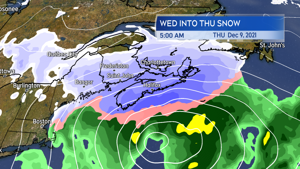 A passing Nor’easter holds east of Nova Scotia wrapping snow into the province late Wednesday into Thursday.
A passing Nor’easter holds east of Nova Scotia wrapping snow into the province late Wednesday into Thursday.
It’s a great setup to get a significant snowfall for Nova Scotia as it comes close enough to bring steadier precipitation, but not directly through which typically results in more of a mix of snow, ice, and rain.
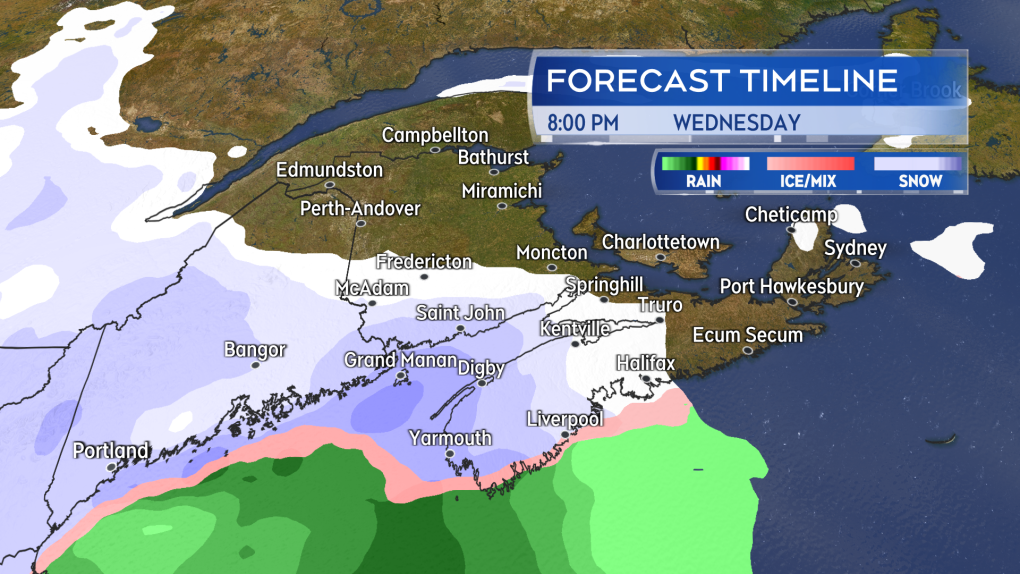 Snow start in earnest Wednesday evening in western Nova Scotia and southern New Brunswick.
Snow start in earnest Wednesday evening in western Nova Scotia and southern New Brunswick.
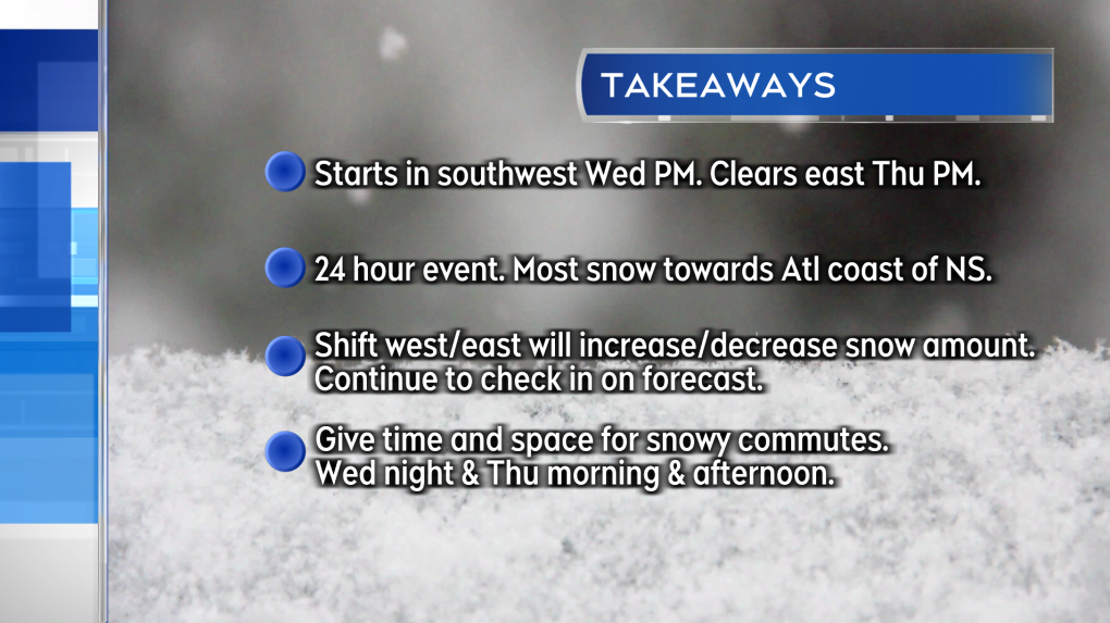
Snow starts as early as Wednesday afternoon in the southwest of Nova Scotia. It will develop across the province Wednesday evening and night, with lighter snow expected in southern New Brunswick and Prince Edward Island. By Thursday morning, the snow eases to flurries for western Nova Scotia and southern New Brunswick. By Thursday afternoon, the snow eases to flurries for eastern Nova Scotia and P.E.I. It’s about a 24 hour event. As an example, Halifax can expect to see the most accumulation between 8 p.m. Wednesday and 8 a.m. Thursday.
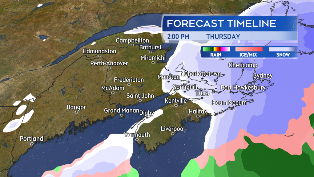 Snow eases to flurries for western areas Thursday morning. Eastern areas through Thursday afternoon.
Snow eases to flurries for western areas Thursday morning. Eastern areas through Thursday afternoon.
The largest snowfall is currently expected near the Atlantic coastline of Nova Scotia, with a general 15 to 25 cm likely. The remainder of Nova Scotia will receive 5 to 15 cm of snow. Parts of southern New Brunswick could pick up totals near 5 cm and in P.E.I. 5 to 10 cm. A significant shift west/east with the system would increase/decrease snow amounts expected for the region. It is recommended that you check in again on your forecast Wednesday. Snowfall Warnings and a Special Weather Statement are in effect for Nova Scotia.
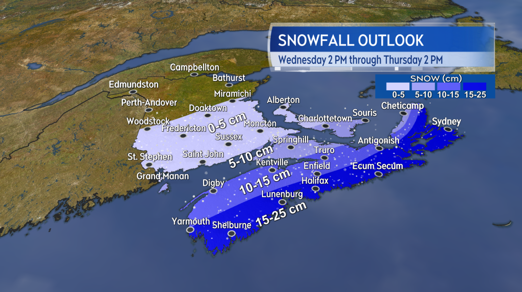 The most snow is expected towards the Atlantic coastline of Nova Scotia. A change in track of the storm could still change expected totals. Check frequently on your forecast through Thursday.
The most snow is expected towards the Atlantic coastline of Nova Scotia. A change in track of the storm could still change expected totals. Check frequently on your forecast through Thursday.
For Nova Scotia you should plan to give yourself extra time and space on the roads. This is especially true for commutes needed Wednesday night and Thursday morning for the west of the province. Thursday morning and afternoon for eastern areas.
The wind with the passing system is not expected to match up to the storm Monday night. The wind will turn north and northeast Wednesday night into Thursday morning. There will be some gusts in the range of 30 to 60 km/h. Gusts could catch falling snow creating periods of blowing snow reducing visibility on roads.
Will what falls stick around for Christmas? Unlikely for most. A warm up and more rain is in the weekend forecast.


CTVNews.ca Top Stories

'A beautiful soul': Funeral held for baby boy killed in wrong-way crash on Highway 401
A funeral was held on Wednesday for a three-month-old boy who died after being involved in a wrong-way crash on Highway 401 in Whitby last week.
'Sophisticated' cyberattacks detected on B.C. government networks, premier says
There has been a "sophisticated" cybersecurity breach detected on B.C. government networks, Premier David Eby confirmed Wednesday evening.
Police handcuff man trying to enter Drake's Toronto mansion
Toronto police say a man was taken into custody outside Drake's Bridle Path mansion Wednesday afternoon after he tried to gain access to the residence.
Biden says he will stop sending bombs and artillery shells to Israel if they launch major invasion of Rafah
U.S. President Joe Biden said for the first time Wednesday he would halt shipments of American weapons to Israel, which he acknowledged have been used to kill civilians in Gaza, if Prime Minister Benjamin Netanyahu orders a major invasion of the city of Rafah.
Rookie goalie Arturs Silovs to start for Canucks in Game 1 vs. Oilers
Rookie goalie Arturs Silovs will start in net for the Canucks as Vancouver kicks off a second-round series against the Edmonton Oilers Wednesday night.
Nijjar murder suspect says he had Canadian study permit in immigration firm's video
One of the Indian nationals accused of murdering British Columbia Sikh activist Hardeep Singh Nijjar says in a social media video that he received a Canadian study permit with the help of an Indian immigration consultancy.
Pfizer agrees to settle more than 10K lawsuits over Zantac cancer risk: Bloomberg News
Pfizer has agreed to settle more than 10,000 lawsuits about cancer risks related to the now discontinued heartburn drug Zantac, Bloomberg News reported on Wednesday, citing people familiar with the deal.
Quebec premier defends new museum on Quebecois nation after Indigenous criticism
Quebec Premier Francois Legault is defending his comments about a new history museum after he was accused by a prominent First Nations group of trying to erase their history.
U.S. presidential candidate RFK Jr. had a brain worm, has recovered, campaign says
Independent U.S. presidential candidate Robert F. Kennedy Jr. had a parasite in his brain more than a decade ago, but has fully recovered, his campaign said, after the New York Times reported about the ailment.
Shopping Trends
The Shopping Trends team is independent of the journalists at CTV News. We may earn a commission when you use our links to shop. Read about us.


Toronto
-
Systemic failure to promote Black officers under microscope as superintendent apologizes for helping racialized police cheat
In emotional and raw testimony at a disciplinary tribunal, the first Black female superintendent in the Toronto Police Service apologized for helping racialized constables cheat a promotional exam.
-
Police handcuff man trying to enter Drake's Toronto mansion
Toronto police say a man was taken into custody outside Drake's Bridle Path mansion Wednesday afternoon after he tried to gain access to the residence.
-
'A beautiful soul': Funeral held for baby boy killed in wrong-way crash on Highway 401
A funeral was held on Wednesday for a three-month-old boy who died after being involved in a wrong-way crash on Highway 401 in Whitby last week.
Calgary
-

Calgary family physician charged with sexual assault of Cowboys patron
A Calgary family physician is accused of sexually assaulting a woman more than a year ago.
-
Suspect in Nijjar killing alleged to have studied briefly at Bow Valley College in Calgary
One of the accused in the murder of British Columbia Sikh activist Hardeep Singh Nijjar appears to have spent a short period of time as a student at Bow Valley College in Calgary.
-
Nenshi taking heat on labour record from fellow Alberta NDP leadership candidates
Candidates vying to be the next leader of Alberta’s Opposition NDP want answers from presumed front-runner Naheed Nenshi about a five-year-old letter that they say signals he is anti-union.
Edmonton
-

Size of Vancouver Island burned in 2023 Alberta wildfires: ABMI report
A group of researchers who studied the historic 2023 Alberta wildfires calls them “remarkable” at least in recent history.
-
Elks report net loss of $3.9M for 2023 as team narrows list of potential new owners
While the Green and Gold are bleeding even more red ink, shareholders of Edmonton's Canadian Football League franchise heard Wednesday at its annual general meeting there's hope on the horizon.
-
Vehicle found burning on Anthony Henday Drive east of Edmonton
Police in Strathcona County are looking for information after a vehicle fire on Anthony Henday Drive.
Montreal
-

English CEGEPs' struggles with Bill 96 requirements show why language law is needed: minister
Quebec's minister for the French language says if English CEGEPs are having a problem with the new French-language exam for students, it only shows that the province's language laws are necessary.
-
Toronto FC beats semi-pro side CS Saint-Laurent 3-0 in Canadian Championship
Matty Longstaff broke a deadlock in the 50th minute and Toronto FC went on to defeat semi-pro side CS Saint-Laurent 3-0 in the opening leg of their Canadian Championship quarterfinal on Wednesday.
-
No more doctor's note: Quebec bill would scrap paperwork for massages, medical equipment
On Wednesday, Labour Minister Jean Boulet announced that he will table a bill to cut red tape, so that family doctors can free up an additional 500,000 medical appointments for patients each year by a plan to put an end to require a medical note in order to be reimbursed by an insurance company.
Ottawa
-

'Summer of discontent': Federal unions vow to fight new 3-day a week office mandate
Federal unions are launching legal challenges and encouraging public sector workers to file "tens of thousands" of grievances over the new mandate requiring federal workers to return to the office at least three days a week in the fall.
-
High school student fatally stabbed in Nepean remembered as 'beloved' son
A 15-year-old who was fatally stabbed last week is being remembered as a "beloved son, brother, cousin, nephew, grandson and friend."
-
1 person injured in afternoon fire in the Glebe
One person was injured Wednesday afternoon in a house fire in the Glebe.
London
-

More than 150 townhomes in northeast London have lost mail service due to off-leash dog
‘It’s a rough situation.’ Townhome residents on Briarhill Avenue have been without mail delivery for about two months.
-
Mother testifies in own defence at disturbing child abuse trial
The mother involved in a shocking child abuse case in London, Ont. took the stand on Wednesday, denying that she ever harmed her children.
-
TSB concludes investigation into cause of London, Ont. freight train fire
More than two weeks after a freight train with several railcars ablaze rolled through the heart of the Forest City, the Transportation Safety Board (TSB) has concluded its investigation.
Barrie
-

Barrie business owner fed up over repeated break-ins since opening
A small business owner in Barrie is fed up after his establishment has been the target of crime multiple times since opening in 2019.
-
Crown seeks 6 years jail time for Barrie woman guilty of impaired driving causing bodily harm
An emotional Cassie Korzenko walked into the Barrie Courthouse Wednesday morning with family members by her side ahead of a sentencing hearing.
-
14-year-old charged after high school lockdown
A 14-year-old from Orillia has been charged with mischief after a threat was made toward an Orillia high school on Wednesday.
Northern Ontario
-

Seven northern Ont. men busted in huge online child exploitation investigation
A province-wide child sexual abuse investigation by Ontario Provincial Police dubbed Project Aquatic has resulted in hundreds of charges, including seven male suspects from northern Ontario.
-
'Ozempic babies': Reports of surprise pregnancies raise new questions about weight loss drugs
Numerous women have shared stories of 'Ozempic babies' on social media. But the joy some experience in discovering pregnancies may come with anxiety about the unknowns.
-
Ontario man devastated to learn $150,000 line of credit isn't insured after wife dies
An Ontario man found out that a line of credit he thought was insured actually isn't after his wife of 50 years died.
Kitchener
-

'The bins aren’t appropriate': Residents react to Waterloo Region’s proposed waste collection program
A pricey plan, proposed by staff for the Region of Waterloo, would see a new fleet of garbage trucks and carts replace bags.
-
'It continues to grow as a waste site': Neighbours frustrated with mess at Bathurst Drive encampment
People in the Bathurst Drive area of north Waterloo say they’ve had enough with a massive pile of garbage at an encampment site located in the green space behind an office park.
-
64 people charged in Ontario child exploitation investigations
Ontario Provincial Police say 64 people have been arrested and a combined 348 charges have been laid in connection with a series of child exploitation investigations that spanned across the province.
Windsor
-

'Predators go where children go': 5 local people arrested, charged through Project Aquatic
Four people from Windsor, one of whom is 16 years old, and one person from Chatham are now charged with offences including possessing, accessing and making available child pornography.
-
'I wouldn’t trade it for anything': Caesars Windsor celebrates 30 years in the community
To celebrate their 30-year presence in the Windsor community, Caesars Windsor employees are rolling up their sleeves this week, volunteering at six local non-profit organizations.
-
Death deemed not suspicious after body found near Tecumseh Mall
Windsor police say the death was not suspicious after a body was found near an east Windsor mall.
Winnipeg
-
'I killed four people': Trial hears video evidence of Jeremy Skibicki at Winnipeg trial
“I killed four people,” alleged serial killer Jeremy Skibicki told two homicide detectives during a recorded interview played as evidence in his trial Wednesday.
-
Proposed class-action lawsuit launched against Manitoba government for use of solitary confinement in prisons
A proposed class-action lawsuit has been filed against the Manitoba government by a previous inmate for the use of solitary confinement, calling the practice, "cruel, inhumane, and degrading treatment."
-
Grab your gear: Camping season set to kick off in Manitoba
Get your gear ready – camping season has officially arrived in Manitoba.
Regina
-

Sask. parents of autistic children denounce lack of specialized learning in schools
Parents of children with autism joined MLAs in the legislature on Wednesday to rally against cuts for specialized learning in schools.
-
Fort Qu'Appelle high school students hold smudge walk to honour MMIWG
On Monday, students from Bert Fox Community High School led a smudge walk through Fort Qu’Appelle to bring awareness to missing and murdered Indigenous women and girls.
-
'Lax environment' contributed to 2020 deaths of 2 SaskPower workers
A Saskatchewan judge has found SaskPower guilty of three workplace-safety related violations over an incident that left two workers dead in Weyburn.
Saskatoon
-

Sask. barista prepares to roast competitors at national coffee competition
A competitor from Saskatoon is heading to Vancouver for a competition that promises to be quite the grind.
-
'Written off': Sask. woman says her brother, who had Down syndrome, fell through the cracks
Tara Jo Kadlec has been advocating for better care for her brother Cory for years.
-
From CTV's archive: Watch the Regina Pats score 17 goals in one 1985 playoff game
There have been some crazy WHL playoff games over the years. But a team scoring 17 goals? In one game?
Vancouver
-

'Sophisticated' cyberattacks detected on B.C. government networks, premier says
There has been a "sophisticated" cybersecurity breach detected on B.C. government networks, Premier David Eby confirmed Wednesday evening.
-
Vancouver bans sale of some butane lighters
The City of Vancouver has decided to prohibit the sale of continuous flame butane lighters and introduced a hefty fine for anyone who violates the new bylaw.
-
Man charged with driving car into Burrard Inlet for alleged streaming stunt
Weeks after someone drove a car into B.C.'s Burrard Inlet – in an apparent stunt that was live-streamed online – a man has been criminally charged.
Vancouver Island
-

B.C. expanding 3 provincial campgrounds this year
Good news for campers looking for a spot this summer: B.C. is expanding three provincial campgrounds, two on Vancouver Island and one on the mainland.
-
B.C. theatre to pay $55K to neurodivergent actor in discrimination case
British Columbia's human rights tribunal has awarded a neurodivergent actor, who was diagnosed with sensory and learning disorders, more than $55,000 after finding that a Kelowna theatre company discriminated against him because of his disabilities.
-
TSB releases report into fatal Vancouver Island floatplane crash
A floatplane crash that killed two people on the west coast of Vancouver Island last summer was caused by a collision with a boat wake or an object in the water, according to an investigation report published by the Transportation Safety Board of Canada Wednesday.
Kelowna
-

Kamloops RCMP issue public warning about 2 men allegedly at centre of 'organized crime conflict'
After four targeted shootings in four days, Mounties in Kamloops are taking the unusual step of warning the public about two men they believe are likely to be targeted in future violent incidents.
-
Community mourns thousands of fish lost as B.C. drought risk looms again
Images of steelhead and trout flicker over long sheets of paper, brought to life in blue and green crayon rubbings by the thousands.
-
4th targeted shooting in as many days in Kamloops: RCMP
A man was taken to hospital with non-life-threatening injuries after a shooting in Kamloops Monday evening, the fourth incident police say is part of an ongoing drug conflict playing out on the city's streets.


