HALIFAX -- As of 9 p.m. Tuesday, Teddy has been declared a post-tropical storm by the National Hurricane Centre.
According to CTV Atlantic chief meteorologist Kalin Mitchell, landfall will be between 7 a.m. and 9 a.m., in the vicinity of Sheet Harbour in eastern Halifax County.
Mitchell expects heavy rain falling to the north and west of that path, with stronger south/southeast wind expected to the east of the landfall point and near coastal gusts 90-110 km/h.
The area of cloudiness denoting the general location of wind and rain produced by the storm system has taken a comma-shaped pattern with the centre of the storm located at the head of the comma.
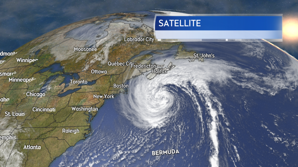 Teddy has begun to take on post-tropical characteristics, growing larger in size and becoming asymmetrical.
The storm is massive. The National Hurricane Center stated in a noon update that the area of tropical-storm force winds and 12-foot seas doubled during the overnight hours.
The centre of Teddy continues to be forecast to reach the eastern Atlantic coastline of Nova Scotia on Wednesday. The time of arrival is estimated to be 8 a.m. to noon. The likely location will be near the border of eastern Halifax Regional Municipality and Guysborough County. Though, the uncertainty in the track still spans an area from Halifax to Cape Breton.
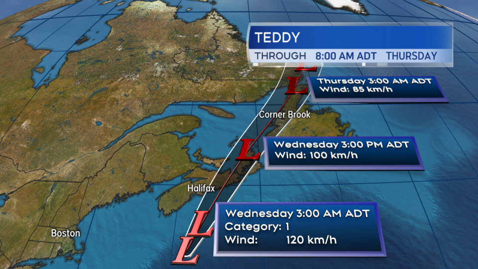 A landfall on the eastern Atlantic coastline of Nova Scotia looks likely on Wednesday. The area of possible landfall continues to range from Halifax to Cape Breton.
Gusts of 80 km/h to 90 km/h will reach the Atlantic coastline of Nova Scotia Tuesday afternoon. Northeast winds will increase into Tuesday evening. A brief lull in the wind is forecast for central Nova Scotia and P.E.I. late Tuesday night. Strong winds will redevelop Wednesday morning and afternoon as the centre of the storm approaches. High winds are forecast to remain in Cape Breton well into Wednesday evening.
Peak gusts will generally range from 50 km/h to 80 km/h. Gusts for higher terrain and exposed areas of the coastline will be 80 km/h to 100 km/h. A brief period of near-coastal gusts of 100 km/h to 120 km/h is a risk just to the east of the landfall point on Wednesday.
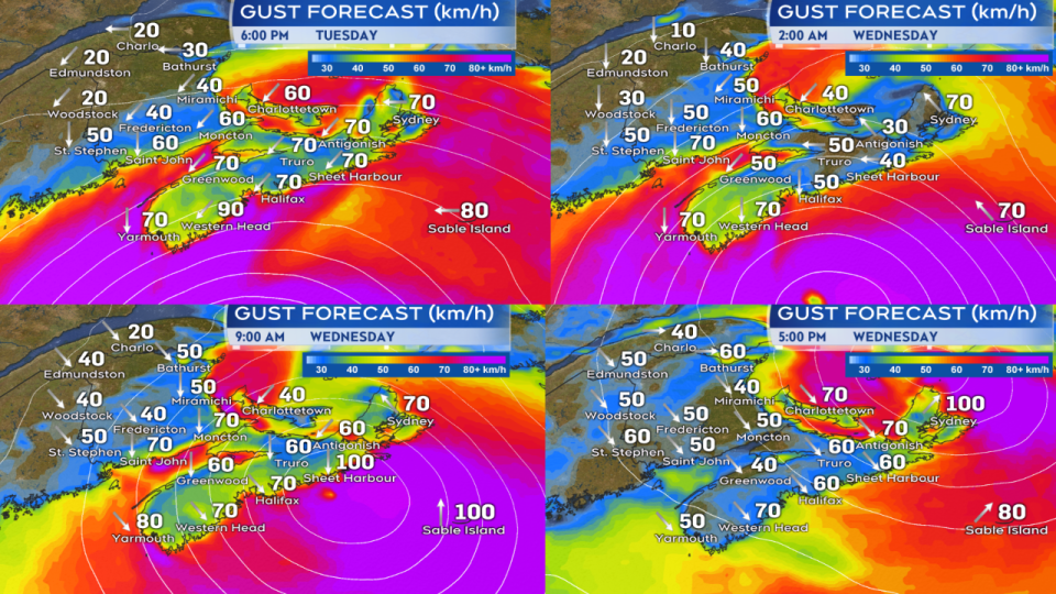 Strong winds are expected on both Tuesday and Wednesday. Well ahead of the centre of the storm Tuesday and then as the centre approaches and passes Wednesday.
Periods of heavy rain may still contribute to flash or localized flooding. The areas at greatest risk of seeing some local amounts of 70 mm to 100 mm is central Nova Scotia through P.E.I. Some of the higher terrain in Cape Breton could see high totals as well, particularly in Victoria County. Rainfall amounts will be varied due to the nature of the embedded downpours within the general area of rain.
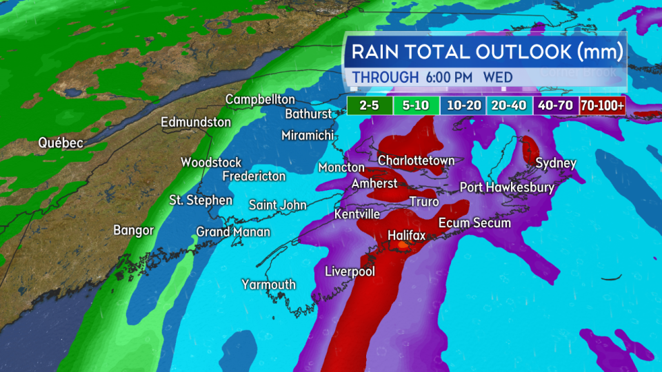 Forecast guidance continues to show the potential for local rainfall amounts of 70-100 mm for parts of the region; a fairly widespread 40-70 mm.
Storm surge warnings continue for the Atlantic coastline of Nova Scotia. High and pounding waves are already present and the risk will be enhanced during high tides. For the Southwest Shore, the period of highest risk is Tuesday afternoon and evening, and for the Eastern Shore, Tuesday evening and Wednesday morning. For Cape Breton, the highest risk will be near high tide early Wednesday morning.
Weather buoys located at East Scotia Slope and LaHave Bank have reported waves of over 10 metres or 33 feet. Even higher seas are expected as Teddy nears.
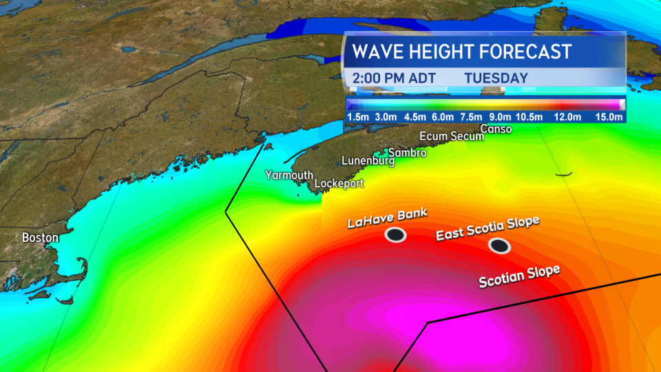 Towering waves have been reported by offshore weather buoys. Even higher waves are still to come for open ocean waters as the storm continues to move in.


