Less humid air to arrive Friday after rain in Maritimes
The area of rain, along with embedded downpours and thunderstorms, continues to clear west-to-east across the Maritimes Thursday afternoon into evening. By 3 p.m. the rain should be in the process of clearing eastern mainland Nova Scotia and Prince Edward Island. By 5 p.m. the last of that rain should clear Sydney and Cape Breton.
The rain has totalled five-to-20 mm for many areas. Some locations have reported totals as high as 30-to-50 mm, likely due to a downpour or thunderstorm moving directly over.
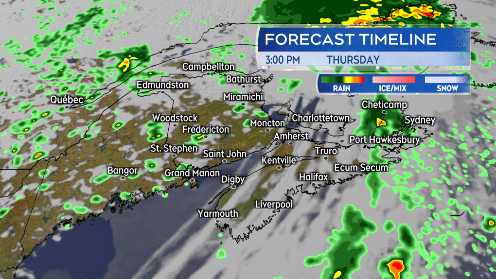 The band of rain clears east Thursday afternoon into early evening. Scattered showers trail behind it. (Source: CTV News Atlantic)
Late day thunderstorm risk
Though the main band of rain is clearing east, there remains a risk of isolated thunderstorms in the Maritimes into Thursday evening. A round of scattered showers is expected to develop in New Brunswick with a risk of isolated thunderstorms among them. The risk extends until about 7-to-9 p.m., after which any developed thunderstorms should be dissipating. The remaining scattered showers move across the Maritimes through the night.
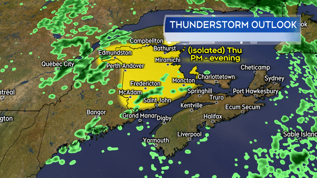 Among the developing Thursday afternoon and evening showers in New Brunswick there is a risk of isolated thunderstorms. (Source: CTV News Atlantic)
Sunny and less humid for Friday
The wind direction becomes northwest behind the passing rain and showers. The northwest wind will draw in less humid air from northern Quebec into the Maritimes. Expect a drier, fresher feel to the air. There is mostly a fair weather mix of sun and cloud for Friday. There is a 30 per cent chance of showers for eastern New Brunswick, Prince Edward Island, and northern/eastern areas of Nova Scotia. High temperatures will be in the high-teens to low-twenties.
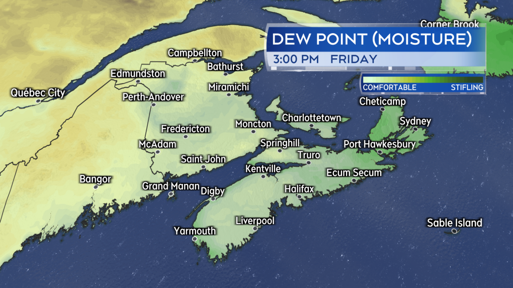 A less humid brand of air brought into the Maritimes for Friday. (Source: CTV News Atlantic)
Canada Day long weekend rain
Saturday’s weather is still looking fair. There will be some increasing cloudiness through the day along with high temperatures in the mid-to-high twenties. There will be comfortable levels of humidity.
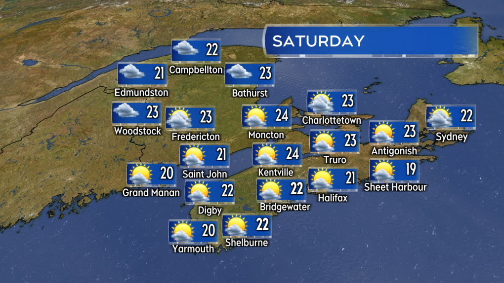 The start of the long weekend is fair. Rain and showers returning for Sunday. (Source: CTV News Atlantic)
Sunday is wet with rain, showers, and fog. There is a risk of downpours and thunderstorms embedded within the rain. There is a gusty southwest wind for both Nova Scotia and Prince Edward Island with peak gusts of 40-to-70 km/h.
Monday still a crapshoot. The front bringing the wet weather Sunday may stall near the Atlantic coastline of Nova Scotia on Monday. That keeps the possibility of rain in the forecast for that province, especially Atlantic coastal areas. It also keeps a chance of showers for Prince Edward Island. New Brunswick looks better with a mix of sun and cloud expected.


CTVNews.ca Top Stories

Who are the richest people in Canada? Here's how many billionaires there are
If you gathered all the wealth that billionaires currently have worldwide, you would have about US$14.2 trillion, according to Forbes Magazine. But what about in Canada alone?
'7 years of regret': Raunchy leg piece wins bad tattoo competition at Edmonton Expo Centre
Friday night was a celebration of mistakes for a small group of body art enthusiasts.
Time crunch, rules mess could plague a Liberal leadership race
Calls have intensified for Justin Trudeau to resign as head of the party he almost single-handedly pulled back from the brink after a decimating electoral defeat in 2011.
Despair in the air: For many voters, the Biden-Trump debate means a tough choice just got tougher
The sound you might have heard after the presidential debate this past week was of voters falling between a rock and a hard place.
Lightning deal Sergachev, Jeannot; Maple Leafs acquire Tanev's rights at NHL draft
General managers wheeled and dealed Saturday in Sin City.
235 flights cancelled as WestJet waits to hear from labour minister on next steps in mechanics strike
WestJet said 235 flights have been cancelled Saturday as it waits to see what the next steps are in its ongoing labour dispute with its mechanics.
A year ago, she drank battery acid to escape life under the Taliban. Today, she has a message for other Afghan girls
Holding a mirror steady in one hand, Arzo carefully applies pencil to her brows as she gets ready for an English lesson a short walk from her home on the outskirts of Pakistani megacity Karachi.
A Florida auctioneer was about to sell an 1800s pocket watch. He learned it was a stolen piece of U.S. presidential history
A pocket watch that belonged to Theodore 'Teddy' Roosevelt was returned to his New York home this week after it was stolen decades ago and later showed up at an auction, according to the FBI and the National Park Service.
U.S. and Europe warn Lebanon's Hezbollah to ease strikes on Israel and back off from wider Mideast war
U.S., European and Arab mediators are pressing to keep stepped-up cross-border attacks between Israel and Lebanon's Iran-backed Hezbollah militants from spiraling into a wider Middle East war that the world has feared for months. Iran and Israel traded threats Saturday of what Iran said would be an 'obliterating" war over Hezbollah.
Shopping Trends
The Shopping Trends team is independent of the journalists at CTV News. We may earn a commission when you use our links to shop. Read about us.


Toronto
-

'It just makes me feel home': LGBTQ2S+ newcomers celebrate first Pride in Canada
When Zhya Aramiy was living in Turkey and Iraq, he had to keep his Pride flags hidden away.
-
One person critically injured in two-vehicle crash in North York
One person was critically injured in a two-vehicle crash in North York Saturday morning, paramedics say.
-
Suspect identified in downtown Toronto fight that seriously injured 2: police
Toronto police have identified a suspect allegedly involved in a fight that sent two people to hospital with serious injuries earlier this month.
Calgary
-

'We left here with what we think is a great haul': Flames draft 10 players in Las Vegas
The Calgary Flames had a busy weekend, drafting 10 players at the 2024 NHL Draft over seven rounds.
-
‘Thank you sincerely’: Calgary water consumption declines 23% Friday as city prepares to test pipe
Calgarians cut their water consumption by 23 per cent Friday, giving Mayor Gondek some good news to announce at her Saturday morning update on the state of the city’s water supply.
-
235 flights cancelled as WestJet waits to hear from labour minister on next steps in mechanics strike
WestJet said 235 flights have been cancelled Saturday as it waits to see what the next steps are in its ongoing labour dispute with its mechanics.
Edmonton
-

Police seek witnesses after body found in Mill Creek Ravine: EPS
A dead person was found in Mill Creek Ravine on Saturday and Edmonton police are investigating the death as suspicious.
-
Charges pending after 3-year-old Edmonton boy struck, killed by truck in marked crosswalk
Police say charges are pending after a boy was killed and his mother and sister were injured in a crash in south Edmonton on Thursday.
-
Serious crash closes Highway 33 south of Kinuso
A section of Highway 33 south of Kinuso was closed Saturday after a serious crash.
Montreal
-

3 dead, multiple injured after fiery crash on Laval roadway
Three people are dead after a fiery crash involving a large truck and three other vehicles north of Montreal Friday afternoon.
-
Provocative or crude: Do some corporate accounts go too far on social media?
In the age of quick attention spans and fleeting infatuations, many large companies are working hard to stay relevant and, most importantly, on-trend.
-
Saku Koivu's son Aatos drafted by Habs in round 3 at NHL Entry Draft
With two picks in the book, the Montreal Canadiens front office now gets set for a slew of picks in rounds two through seven in the 2024 NHL Entry Draft. The Habs' next pick was the son of former captain Saku Koivu: Aatos.
Ottawa
-

19-year-old killed after shooting in Ottawa's east-end
Ottawa police are investigating after a man was killed during a shooting in Ottawa's east end on Friday night.
-
Meet the 2024 Ottawa Senators draft picks
The Ottawa Senators welcomed six new players to their bench during the NHL draft in Las Vegas this weekend.
-
What's happening in Ottawa this weekend: June 28-July 1
CTV News Ottawa looks at things to do in Ottawa during the Canada Day long weekend.
London
-

London-based organization hoping to 'reconnect' 2SLGBTQIA+ community
The London, Ont.-based group ‘Why We March’ (WWM) is using money from an Ontario Trillium Foundation (OTF) grant to 'fill a void in the community.'
-
Four London Knights, Londoner selected in NHL Draft
It was a special night for a pair of London Knights, and one London-born player at the NHL Draft in Las Vegas, NV.
-
Food drive 'weigh-off' nets 700 lbs. of food for Huron County
It started as a company food drive and grew into a friendly competition between three Clinton businesses that benefitted Huron County’s less fortunate.
Barrie
-

Police cruiser catches fire in overnight assault investigation
Eyewitness photos and video show an OPP cruiser that caught on fire amid an aggravated assault investigation in Orillia.
-
Six people taken to hospital following crash near Alliston
Six people are in hospital after a crash near Alliston Saturday morning.
-
Severe thunderstom watch issued for Simcoe Muskoka
A severe thunderstorm watch has been issued for parts of Simcoe Muskoka.
Northern Ontario
-

Sudbury senior to be homeless after apartment eviction
A Greater Sudbury senior says she will be homeless after being evicted from her apartment.
-
Police cruiser catches fire in overnight assault investigation
Eyewitness photos and video show an OPP cruiser that caught on fire amid an aggravated assault investigation in Orillia.
-
Most of Northeastern Ont. under a severe thunderstorm watch, warnings now issued in some communities
Many areas in northeastern Ontario are under a severe thunderstorm watch – with some now under severe thunderstorm warnings, Environment Canada said Saturday.
Kitchener
-

Occupy UW calls university's court order a 'scare tactic' to silence students
Members of a pro-Palestinian encampment at the University of Waterloo have broken their silence surrounding a lawsuit and injunction filed by the school.
-
Eight people displaced by Kitchener house fire
Officials say no one was hurt after flames destroyed the front porch of a Kitchener home on Friday.
-
More than 150 Cargill workers turn to Guelph Food Bank as strike enters second month
The strike at a Cargill meat processing plant in Guelph has now entered its second month, leaving many employees in a difficult situation.
Windsor
-

'Active investigation' in downtown Windsor: Police
Windsor police are conducting what they’re calling an ‘active investigation’ at 920 Ouellette Ave.
-
Two people arrested for allegedly stabbing each other: WPS
The Windsor Police Service (WPS) has arrested two suspects who allegedly stabbed one another during a dispute.
-
WECHU seizes 99 illegal high-nicotine vape products from one store in recent youth access crackdown
A recent inspection by the Windsor-Essex County Health Unit (WECHU) resulted in the seizure of 99 illegal high-nicotine vapour products from a store accused of attempting to sell them to a customer under 18.
Winnipeg
-

'It's something to see': How water towers have transformed into Manitoba skyline icons
Water towers in Manitoba have seen a transformation over the years. While some of these pieces of infrastructure, which were designed to bring water to residents, have faded and disappeared over time, others have begun a new life – places that showcase history, where memories are made and a sense of pride is born.
-
‘The number is evolving’: Over 10 WestJet flights cancelled at Winnipeg airport due to strike
More and more WestJet flights are getting cancelled due to an ongoing labour dispute between the airline and its mechanics.
-
No injuries reported in 5 overnight fires: WFPS
Winnipeg Fire Paramedic Service said it is investigating after five fires broke out between Friday evening and Saturday morning.
Regina
-

Regina man suffers 'severe injury' from large bladed weapon, RPS seeks assistance
Regina police are seeking assistance after a man suffered an injury late Friday night in the North Central neighbourhood.
-
Gamers battle it out at weekend Summer Arcadian tournament in Regina
Gamers from all across Saskatchewan battled it out over the weekend, making for a fun showdown at the Lazy Owl in Regina.
-
How Sask. RCMP used a drone to help stranded hikers
After a group of hikers became stranded by an unexpected rise in water levels, RCMP officers on-scene took to the skies to track them down.
Saskatoon
-

'They have nowhere to go': Hundreds walk in Saskatoon to raise awareness for domestic violence
More than one hundred walkers showed up in Saskatoon on Saturday to raise awareness for domestic abuse and homicide in the city.
-
Pedestrian struck by car in Prince Albert airlifted to Saskatoon
A 38-year-old man from Prince Albert is recovering in Saskatoon after being struck by a car on Friday night.
-
Sask. may consider ban on cellphone use in classrooms
Saskatchewan may consider a ban on cellphone use in classrooms.
Vancouver
-

'This amount of stress is awful': B.C. woman says senior relatives stranded in Calgary amid WestJet strike
A Maple Ridge, B.C. resident says her mother and mother-in-law’s first trip to Canada has ended on a frustrating note after their flight home was suddenly cancelled amid a strike at WestJet.
-
Dozens of B.C. flights cancelled amid WestJet mechanics strike
Dozens of WestJet flights have been cancelled at airports across B.C. Saturday after the airline's mechanics' union went ahead with strike plans Friday evening.
-
Metro Vancouver Transit Police hand out 268 tickets for driving in bus lanes during crackdown
Metro Vancouver Transit Police say they handed out 334 tickets to drivers across the region during a four-day crackdown on misuse of bus lanes.
Vancouver Island
-

Dozens of B.C. flights cancelled amid WestJet mechanics strike
Dozens of WestJet flights have been cancelled at airports across B.C. Saturday after the airline's mechanics' union went ahead with strike plans Friday evening.
-
Langford rainbow crosswalk vandalized twice in 48 hours: RCMP
Police have released surveillance video of two vandalism incidents at a rainbow crosswalk in Langford, B.C., and are appealing to the public to help identify the suspects involved.
-
As fall elections loom, are fears for the state of democracy in Canada justified?
Is Canada's democracy truly under threat? Political scientists say while Canadian politics and institutions are facing a myriad of concerns, the situation isn't dire overall.
Kelowna
-

Man stabbed in Kelowna, suspect at large: RCMP
Mounties in Kelowna say a suspect is at large after a man was stabbed in the city Sunday afternoon.
-
Police still investigating cause after woman found dead in Kelowna park
Police are remaining tight-lipped about a woman’s death in a Kelowna park on Friday.
-
Man shot dead in Princeton, B.C., was high-ranking gang member, court records suggest
Police have identified a man found dead in B.C.’s Interior last weekend as Donald “Donnie” Lyons.


