Records to watch as temperatures soar in the Maritimes Wednesday
Records fall
As we moved into the late afternoon, high temperature records for a June 19 fell across all three Maritime provinces.
Many other weather observation sites in the region came within a degree or less of their standing record highs.
As of 5 p.m. ADT Bathurst, N.B., has had the hottest temperature in the country as recorded at Environment Canada-monitored weather stations. That high temperature recorded as 37.6 degrees Celsius.
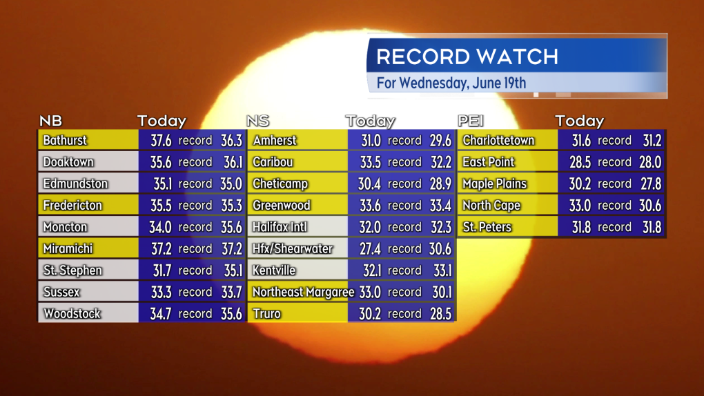 New daily high temperature records set in the Maritimes. Unofficial at this time but some of the sites that set new records are shown here highlighted in yellow. (Source: CTV Atlantic)
Peak heat and humidity
The Maritimes is now into the peak of the spell of hot and humid weather. Similar conditions are expected on Thursday. Heat warnings remain in effect for all three Maritime provinces as not only will the days be very hot, but the nights will be very warm, offering little relief.
A cold front moves across the Maritimes late Thursday into early Friday. Less humid air will filter into the Maritimes on Friday. Both temperature and humidity are forecast to fall from the levels of Wednesday and Thursday. Temperature and humidity will both fall a bit more for the start of the weekend.
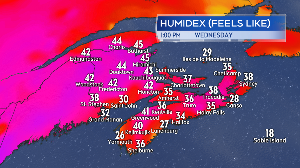 Afternoon humidex values in the Maritimes, or what it feels like, taking into account temperature and humidity, well into the 30s and in cases the 40s.
Risk of thunderstorms
Heat and humidity can be fuel for thunderstorms. There is a low chance of afternoon and evening thunderstorms in New Brunswick for Wednesday afternoon and evening. Any thunderstorms that do develop will be isolated and so for any given community it is about a 20-30 per cent chance.
There is a higher risk of scattered thunderstorms in the Maritimes Thursday.
The thunderstorm development on Thursday would be triggered by the cold front moving north to south across the Maritimes. The highest risk for Thursday afternoon and early evening will be in southern New Brunswick, Prince Edward Island, and eastern Nova Scotia. There will also be a Thursday evening and night risk for thunderstorms in western Nova Scotia.
Due to the heat and humidity that will have built up, it is possible some of the thunderstorms could be strong or severe. Hazards would include lightning, strong localized wind gusts, and downpours.
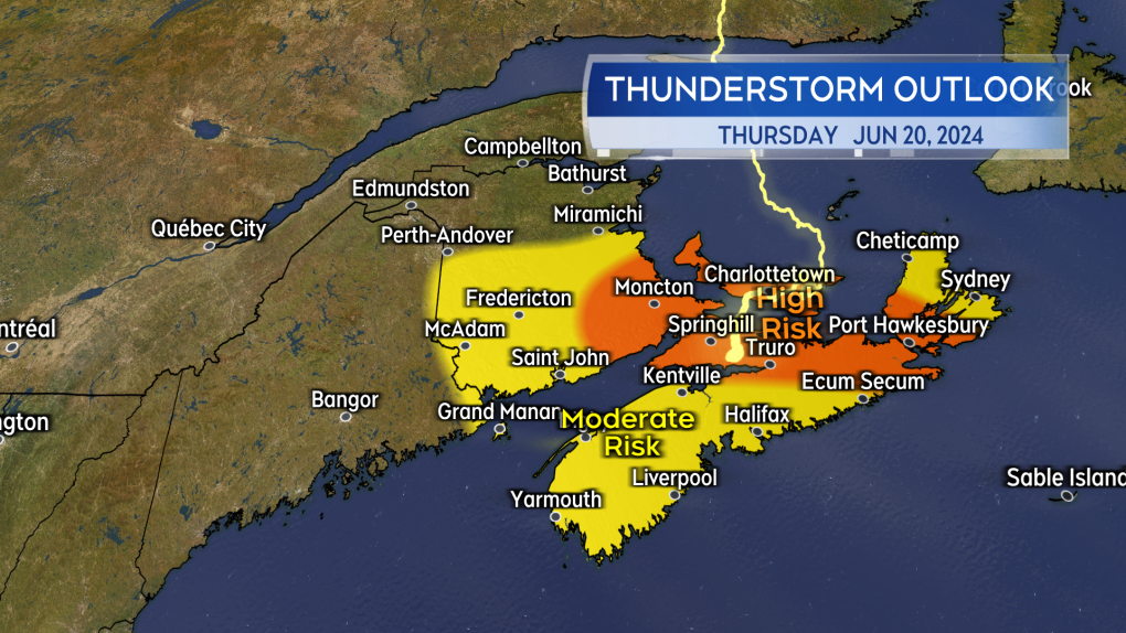 There will be a higher chance of thunderstorms in the Maritimes Thursday along with a higher risk that some of them could become severe.
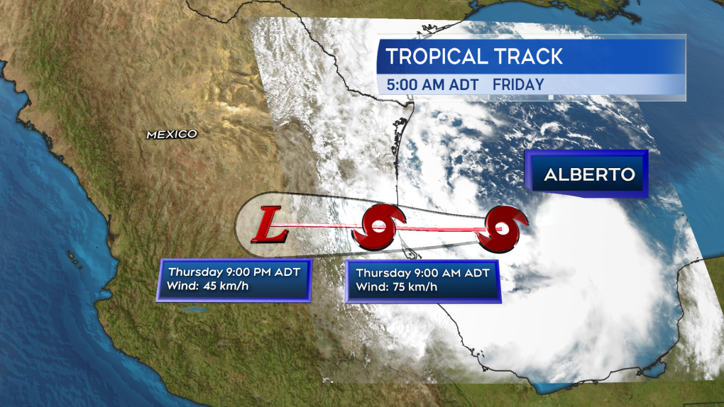
Tropical Storm Alberto
Tropical Storm Alberto developed Wednesday morning in the Gulf of Mexico – the first named storm of the 2024 Atlantic hurricane season. The National Hurricane Center is issuing advisories and forecasts for the storm. The storm is forecast to move onshore near the border of the provinces of Tamaulipas and Veracruz, Mexico, early Thursday morning.
The storm could bring areas of rain, as much as 120 to 250 mm, to parts of northeastern Mexico and southern Texas. The rain will bring a risk of flash flooding and a risk of mudslides where it comes down in more mountainous terrain.
More pictures captured during the Maritimes' heat wave can be seen here.
 The forecast cone for Tropical Storm Alberto in the Gulf of Mexico per the National Hurricane Center.


CTVNews.ca Top Stories

More victims come forward in Ottawa rental scam
More people in Ottawa have come forward who say they've fallen victim to a real estate scam, with scammers posing as real estate agents trying to rent real properties.
Bill Cobbs, 'Air Bud' and 'The Sopranos' actor, dies at 90
Bill Cobbs, the veteran character actor who became a ubiquitous and sage screen presence as an older man, has died. He was 90.
'Worrying rumours' of planned 'non-consensual sexual acts' at after-prom party prompts Quebec police investigation
Police south of Montreal are investigating, and a school centre has asked parents not to allow their children to attend an after-prom party, after 'worrying rumours that unsavoury events were be planned by certain individuals related to drugs and non-consensual sexual acts.'
Canucks season ticket holder speaks out after membership revoked
Peter Wortman has been a Vancouver Canucks season ticket holder for 33 years, and was planning to sign on again for 2024/2025. But earlier this month, he got an email saying his full-season membership had been revoked, because the team believes he’s a ticket broker.
Military flees Bolivia government palace after coup attempt fails, general taken into custody
Armoured vehicles rammed the doors of Bolivia's government palace Wednesday in an apparent coup attempt, but President Luis Arce vowed to stand firm and named a new army commander who ordered troops to stand down.
Oilers stars McDavid, Draisaitl played through injuries in playoffs: coach
The head coach of the Edmonton Oilers says some of the team's top stars were playing through major injuries during their Stanley Cup playoff run.
Canadian businessman Frank Stronach facing new charges in connection with historical sexual assault investigation
Canadian businessman Frank Stronach is facing eight new charges after police say they've identified additional victims as part of an investigation into historical sexual assault allegations.
What you should know about the tick-borne disease anaplasmosis
Cases of a tick-borne illness called anaplasmosis are on the rise globally, and that includes across Canada. Biology professor Vett Lloyd says it is important to understand the risk factors for contracting anaplasmosis, and recognize symptoms of an infection, as the disease becomes more prevalent.
'I'm sorry, God': Accused at Coutts border blockade cried when protest abandoned
Anthony Olienick, sitting alone in an empty police interrogation room, breaks down in tears when he learns the COVID-19 protest blockade at Coutts, Alta., has disbanded in part because of his arrest.
Shopping Trends
The Shopping Trends team is independent of the journalists at CTV News. We may earn a commission when you use our links to shop. Read about us.


Toronto
-

Why a New Zealander has travelled across the world to Toronto to deliver a letter
Walking up to a home in midtown Toronto, Jonny Beardmore has come from across the world to do something both profound and quite simple.
-
Canadian businessman Frank Stronach facing new charges in connection with historical sexual assault investigation
Canadian businessman Frank Stronach is facing eight new charges after police say they've identified additional victims as part of an investigation into historical sexual assault allegations.
-
Ford dodges questions about Ontario Science Centre closure during Pearson appearance
Appearing in Mississauga on Wednesday, Premier Doug Ford dodged reporters' questions about the abrupt closure of the Ontario Science Centre last week.
Calgary
-

Calgary woman reunites with woman she says saved her life
A Calgary mother who is battling breast cancer and suffered a recent serious health scare got the opportunity to thank the stranger who she says saved her life.
-
Calgary family donates $75 million philanthropic gift to help transform Arts Commons into the Werklund Centre
Arts Commons says a local benefactor has stepped up to help pay for a major upgrade, which will revolutionize the facility.
-
Neil Young cancels July 20 Calgary concert
Neil Young has just cancelled next month’s Calgary concert.
Edmonton
-

Oilers stars McDavid, Draisaitl played through injuries in playoffs: coach
The head coach of the Edmonton Oilers says some of the team's top stars were playing through major injuries during their Stanley Cup playoff run.
-
'Armed and dangerous' man wanted for unprovoked attack with machete in Alberta: RCMP
Police are looking for a man they say is responsible for an unprovoked machete attack in eastern Alberta.
-
Work begins to transform cluster of downtown parking lots into urban park
Edmonton's newest urban park is set to soon spring from a large, overgrown parcel of parking lots in the city's core.
Montreal
-

Police raid at Motel St-Jacques leaves residents scrambling to find new housing
Residents of Montreal's Motel Saint-Jacques have been given a week and a half to leave following a major police raid Thursday. Montreal police say for years, the hotel was a hotbed for sex work, drugs and violence.
-
'Worrying rumours' of planned 'non-consensual sexual acts' at after-prom party prompts Quebec police investigation
Police south of Montreal are investigating, and a school centre has asked parents not to allow their children to attend an after-prom party, after 'worrying rumours that unsavoury events were be planned by certain individuals related to drugs and non-consensual sexual acts.'
-
Tenant who fought renoviction getting compensated by major developer
A Montreal tenant who fought a potential renoviction has won a settlement with the developer to keep her in the neighbourhood and with a reasonable rent.
Ottawa
-
More victims come forward in Ottawa rental scam
More people in Ottawa have come forward who say they've fallen victim to a real estate scam, with scammers posing as real estate agents trying to rent real properties.
-
Neil Young and Crazy Horse cancel Ottawa Bluesfest appearance as illness sidelines tour
Neil Young and Crazy Horse were to be the headline act on July 11 at Ottawa Bluesfest, but the group has cancelled upcoming tour dates because of illness.
-
Ottawa Train Yards placed in receivership over owner's unpaid $39 million loan
One of Ottawa's largest shopping centres has been placed in receivership over an outstanding $39 million loan by the owner of the property. The Ontario Superior Court of Justice appointed Grant Thornton Limited as receiver and manager of the assets of Ottawa Train Yards on Industrial Avenue.
London
-

Educational charity director charged with fraud
Laura Pethick was hired as the executive director of Foundation for Education Perth Huron in July of 2021. Three years later, she’s accused of defrauding the charity of thousands of dollars.
-
LHSC $150M short: New 90-day target set to address crisis
London Health Sciences Centre (LHSC) said they are facing “significant budget pressures” in a statement released on Wednesday. With a deficit of $78.1 million last fiscal year, this year’s projections are estimated to run up to $150 million.
-
Mayor of Sarnia calls on senior governments to solve urban encampment crisis
At Rainbow Park on the south side of downtown Sarnia, security officers walk a beat of a different kind – one with grass below their feet rather than pavement.
Barrie
-
Suspects impersonating police officers make traffic stop in New Tecumseth
Provincial police in New Tecumseth are investigating and warning the public after a report of two men posing as officers who conducted a traffic stop.
-
Armed robberies at Wasaga Beach gas station under investigation
Police believe the same suspect may have robbed a Wasaga Beach gas station twice in the past week.
-
Veteran Barrie police officers face legal battles amid allegations
High-ranking veteran Barrie police officers Bruce Gardiner and Valarie Gates had separate hearings on Wednesday, each facing prosecution in criminal court and under the Police Services Act.
Northern Ontario
-

House explodes in Transcona, others dealt significant damage: WFPS
The City of Winnipeg is asking people to avoid the area of Camrose Bay after a house exploded.
-
Sudbury, Ont., Crown takes over criminal prosecution of Ontario’s Ministry of Labour
In court on Wednesday, Sudbury Crown attorney Kara Vakiparta moved to take over what had been the private prosecution of Ontario’s Ministry of Labour on a charge of criminal negligence causing death related to a 2006 mining fatality.
-
Police watchdog investigates after shooting death of a man in Kenora
The province’s Special Investigations Unit is investigating the circumstances surrounding the shooting death of a 57-year-old man in Kenora on Tuesday afternoon.
Kitchener
-

Cambridge tenants call living situation 'unbearable' as they wait for repairs from March flood
Residents at a Cambridge apartment building have been waiting four months for management to make repairs after a flood ruined four units.
-
Rentals scarce as students on University of Guelph residence waitlist scoop up available units
Some are calling it the Hunger Games of student housing.
-
Company closing Kitchener factory, blames cost of development and government overregulation
A modular construction company has decided to close up shop in Kitchener.
Windsor
-

School board trustees sanction colleague, despite public notice that meeting was cancelled
When uniformed Windsor police officers were called to clear the Greater Essex County District School Board (GECDSB) gallery on Tuesday, they informed attendees that the trustees were going home and the meeting they came to observe would not be happening. However, this was not the case.
-
'A mere courier': Windsor judge sentences Brampton man to 12 years in prison
Mohamed Ahmed Abdirahman, 40, was previously convicted of importing and possessing 200 kilograms of pure methamphetamine. Officers with the Canada Border Services Agency (CBSA) at the Ambassador Bridge discovered the drugs on Christmas Eve 2019.
-
Weather alerts in effect for region
A severe thunderstorm warning is in effect for Chatham-Kent, Rondeau Park, Western Elgin County, and Eastern Lambton County. Windsor-Essex is under a rainfall warning.
Winnipeg
-

No charges for driver in 2023 Manitoba bus crash that killed 17 seniors: RCMP
Manitoba RCMP and Crown prosecutors will not lay charges against the driver of a bus involved in a crash with a semi-truck in 2023.
-
Neil Young concerts cancelled due to illness
Neil Young’s Crazy Horse will not play in Winnipeg next month.
-
Winnipeg woman wins $1M lottery jackpot
A Winnipeg woman is officially a millionaire after winning a Western Max lottery prize.
Regina
-

Regina's Breast Health Centre under construction, expected to open early 2025
The new Breast Health Centre in Regina is currently under construction and expected to open early next year.
-
'It's an overreach': Regina-born actor criticizes Parent's Bill of Rights
Regina-born actor Tatiana Maslany took the opportunity Wednesday to publicly criticize Saskatchewan's controversial Parent's Bill of Rights.
-
Police asking for footage, information related to yard sale assault
The Regina Police Service (RPS) is urging the public to share footage or information surrounding a serious assault committed at a yard sale late last week.
Saskatoon
-

Sask. teen, 15, charged in fatal spring crash
A 15-year-old boy is facing multiple charges in relation to a fatal crash that killed a 16-year-old boy in April.
-
Sask. man accused of driving drunk, killing scooter rider released from jail
A man accused of killing a man on an electric scooter while driving drunk has been released from jail.
-
'It was a struggle but we got through it': Sask. grads celebrate triumphant end after turbulent journey
It’s a big week for Grade 12 graduates across Saskatchewan who are marking the end of their high school careers.
Vancouver
-

Buying time: Inside the AI technology trained on B.C. wildfires
As frontline crews battled the worst wildfire season in B.C. history, a pilot project unfolded at a frantic pace at the BC Wildfire Service headquarters in Kamloops.
-
Canucks season ticket holder speaks out after membership revoked
Peter Wortman has been a Vancouver Canucks season ticket holder for 33 years, and was planning to sign on again for 2024/2025. But earlier this month, he got an email saying his full-season membership had been revoked, because the team believes he’s a ticket broker.
-
Vancouver traffic radio station AM 730 goes off the air
On Wednesday, Metro Vancouver’s traffic radio station AM 730 disappeared from the airwaves.
Vancouver Island
-

5 kittens rescued from site of human-caused wildfire on Vancouver Island
Five kittens are being treated for burns after being rescued by firefighters on Vancouver Island last week, according to the BC SPCA.
-
Addiction recovery home for new moms first of its kind on Vancouver Island
Come summer’s end, six new moms and their babies will be healing from addiction together in a Greater Victoria home.
-
Buying time: Inside the AI technology trained on B.C. wildfires
As frontline crews battled the worst wildfire season in B.C. history, a pilot project unfolded at a frantic pace at the BC Wildfire Service headquarters in Kamloops.
Kelowna
-

Man stabbed in Kelowna, suspect at large: RCMP
Mounties in Kelowna say a suspect is at large after a man was stabbed in the city Sunday afternoon.
-
Police still investigating cause after woman found dead in Kelowna park
Police are remaining tight-lipped about a woman’s death in a Kelowna park on Friday.
-
Man shot dead in Princeton, B.C., was high-ranking gang member, court records suggest
Police have identified a man found dead in B.C.’s Interior last weekend as Donald “Donnie” Lyons.


