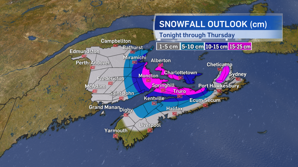
The second, and stronger, of two low-pressure systems impacts the Maritimes on Wednesday night and Thursday.
The storm will pack a mix of rain and heavy, wet snow along with high and gusty winds. The most snow and highest winds are both expected in eastern areas of the region. The southeast of New Brunswick, northern mainland Nova Scotia, Prince Edward Island, and the Highlands of Cape Breton will likely see the most snow with amounts ranging 15 to 30 centimetres. Other areas of the Maritimes will see lighter snow or a mix of rain and snow that will keep amounts from just a trace up to five to 10 slushy centimetres.
Expect the major road routes through northern Nova Scotia and into southeastern New Brunswick and P.E.I. to be impacted by winter road conditions. A series of snow and winter storm warnings has been issued by Environment Canada for these areas.
Winds will increase Wednesday night into Thursday morning. Eastern Nova Scotia and P.E.I. can expect north and northeast gusts peaking from 80 to 100 km/h. The remainder of the Maritimes can expect northerly gusts peaking from 40 to 80 km/h, with the stronger gusts at exposed areas of the coast. The winds will gradually ease Thursday evening, night, and Friday morning.
Travelers should monitor for delays or cancellations in ferry services and possible restrictions on the Confederation Bridge.
The strong northeast winds will create a rough surf on parts of the coast. Storm surge warnings have been issued for Guysborough, Richmond, and Cape Breton counties. For those areas, there is a risk of coastal flooding particularly at high tide which will be near midnight Wednesday into Thursday.
High pressure moving in will bring calmer weather to the Maritimes on Friday and Saturday.


