April rain, showers return to the Maritimes
 A cluster of thunderstorms exiting Texas on satellite imagery. The system matures and brings rounds of rain and showers to the Maritimes. (Courtesy of the College of DuPage)
The ridge of high pressure that favoured the Maritimes with mostly clear and excellent viewing conditions for the solar eclipse at the start of the week is starting to shift east. As it moves to a position east of the Maritimes, cloud cover will increase from the west. The cloud is accompanied by a chance of showers in western New Brunswick and southwestern Nova Scotia late Wednesday afternoon through night. Further increased cloudiness and a chance of scattered showers for the Maritimes on Thursday.
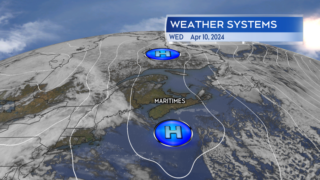 High pressure in place Wednesday gave a mostly sunny start to the day. The system moves to our east by Thursday. (Source: CTV News Atlantic)
Texas thunderstorms and downpours play a role
A slow-moving cluster of thunderstorms and downpours that has brought concerns of flooding and flash flooding to the state of Texas Tuesday and Wednesday plays a role in the expected rain for the Maritimes on Friday. The area of thunderstorms will mature into a large low-pressure system as it moves northward into Ontario by the end of this week. While the centre of that weather system doesn’t move directly into the Maritimes, the associated weather fronts will sweep through Thursday night and Friday. The fronts bringing rounds of rain and showers along with them.
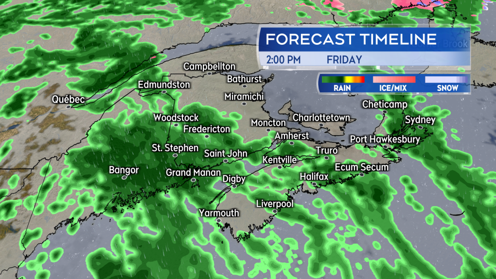 Rounds of rain and showers along with patchy fog or drizzle expected Thursday night through Friday. Lingering showers possible for the start of the weekend. (Source: CTV News Atlantic)
Rain expected and April averages
Mostly patchy showers, drizzle, and fog are expected Thursday night. Periods of rain on Friday will be followed by further scattered showers on Saturday. Early indications are for a general five-to-20 mm rainfall for the Maritimes but with possible pockets of 20-to-40 mm. Areas that could pick up the higher rain totals include parts of southern New Brunswick and Atlantic coastal Nova Scotia. That is a pretty typical spring rain event for the region and as long as there is not a significant increase in the amount of rain expected, it doesn’t raise much of a risk for flooding or flash flooding.
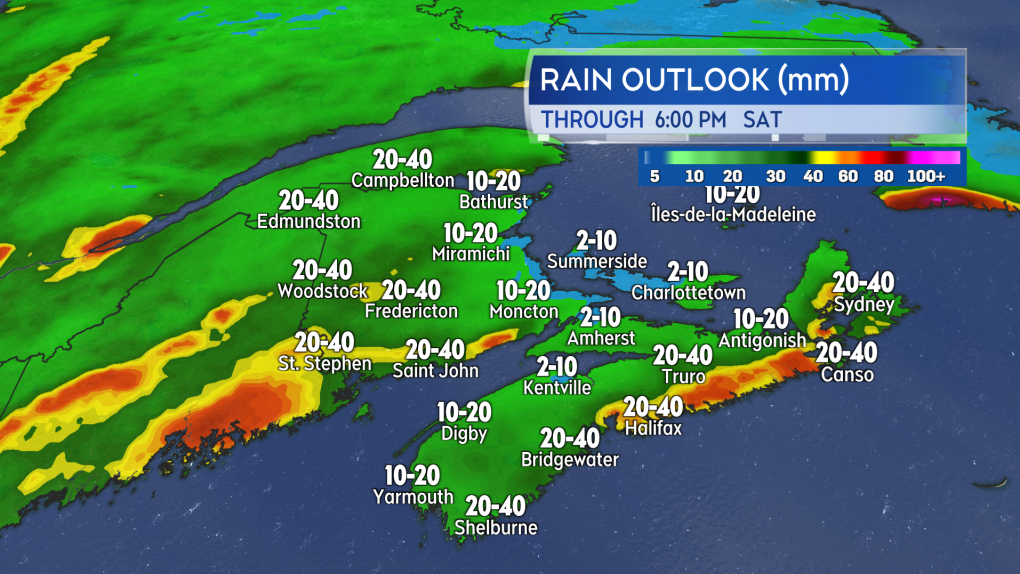 A widespread five-to-20 mm of rain through the end of the week. Pockets of 20-to-40 mm possible. (Source: CTV News Atlantic)
Despite the saying “April showers bring May flowers,” the month of April isn’t the rainiest in the Maritimes. Average rainfall for the month for the provincial capitals ranges between 60 and 98 mm. For Fredericton it is the seventh rainiest month by average, for Halifax it is the sixth rainiest month by average, and for Charlottetown the eighth rainiest month by average.


CTVNews.ca Top Stories

Prince William and Kate release photo of daughter Charlotte to mark ninth birthday
Prince William and his wife Kate released a picture of their daughter Charlotte to mark the princess's ninth birthday on Thursday.
This Canadian restaurant just lowered its prices. Here's how it did it
A Canadian restaurant lowered its prices this week, and though news of price tags dropping rather than climbing sounds unusual, the business strategy in this case is not, according to experts in the field.
Concerns about Plexiglas prompt inspections at some Loblaws locations in Ottawa
Inspections are underway at more than one Loblaws location in Ottawa after complaints were filed about tall Plexiglas barriers.
'Oh, there you go': Tyler Black, son of veteran broadcaster Rod Black, has memorable Major League Baseball debut
Canadian baseball player Tyler Black made a major splash in his first-ever big league game for the Milwaukee Brewers on Tuesday night.
Groundbreaking American guitarist Duane Eddy dies age 86
Guitarist Duane Eddy, best known for twangy riffs on hits such as 'Rebel Rouser' and 'Cannonball,' has died at the age of 86.
Facial reconstruction reveals what a 40-something Neanderthal woman may have looked like
Scientists studying a Neanderthal woman's remains have painstakingly pieced together her skull from 200 bone fragments to understand what she may have looked like.
Weight-loss drug Wegovy available in Canada starting May 6
The makers of Ozempic say their weight-loss drug Wegovy will be available to patients in Canada starting Monday.
Five human skeletons, missing hands and feet, found outside house of Nazi leader Hermann Goring
Archeologists have unearthed the skeletons of five people, missing their hands and feet, at a former Nazi military base in Poland.
Ontario man loses $1,500 applying for Nexus cards on social media
The trusted traveller program between Canada and the United States is extremely popular and almost two million Canadians have a Nexus card.
Shopping Trends
The Shopping Trends team is independent of the journalists at CTV News. We may earn a commission when you use our links to shop. Read about us.


Toronto
-

This Canadian restaurant just lowered its prices. Here's how it did it
A Canadian restaurant lowered its prices this week, and though news of price tags dropping rather than climbing sounds unusual, the business strategy in this case is not, according to experts in the field.
-
Ontario man loses $1,500 applying for Nexus cards on social media
The trusted traveller program between Canada and the United States is extremely popular and almost two million Canadians have a Nexus card.
-
Companies letting customers opt out of Mother's Day ads
In an effort to balance the profitability of Mother's Day with the pain it causes some people, some brands are offering customers the choice to opt out of Mother's Day email advertising.
Calgary
-

ASIRT on track for busiest year on record
Alberta's police watchdog is on pace for its busiest year ever, while it also works through a backlog of investigations from up to six years earlier.
-
One in custody after man suffers gunshot wound in Okotoks, Alta., incident
An Okotoks, Alta., man was rushed to hospital on Wednesday afternoon, believed to have been shot in his own home.
-
Fort Calgary announces rebranding strategy
Fort Calgary will announce its new name and plans for the future on Thursday.
Edmonton
-

Oilers dominate special teams to eliminate Kings in 5 games
The Edmonton Oilers and Los Angeles Kings played a tight-checking series at even strength. But the special teams matchup was lopsided - and that's why it ended in five games.
-
ASIRT on track for busiest year on record
Alberta's police watchdog is on pace for its busiest year ever, while it also works through a backlog of investigations from up to six years earlier.
-
Cadence Weapon takes aim at the algorithm in technology-critical album
Cadence Weapon says the release of his tech-skeptical rap album couldn't be timed any better thanks to Drake's latest diss battle.
Montreal
-

McGill community told not to use Roddick Gates due to planned protest
McGill University is asking people not to use the entrance to its downtown campus via the Roddick Gates on Sherbrooke Street.
-
Three Quebec men from same family father hundreds of children
Three men in Quebec from the same family have fathered more than 600 children.
-
Gunshots reverberate through Vieux-Longueuil, no arrests made
Longueuil police are investigating after gunfire rang out on Louise Street near Chambly Road.
Ottawa
-
 BREAKING NEWS
BREAKING NEWS 'Serious' residential high-rise building fire on Donald Street leaves 2 children, adult in critical condition
Ottawa Fire Services says two children and one adult were taken to hospital in critical condition after a fire broke out in a residential high-rise building on Donald Street and St. Laurent Boulevard Thursday morning.
-
It feels like spring this Thursday in Ottawa, here's when it'll start to rain
A good start to the day this Thursday with a mix of sun and cloud along with warm temperatures in Ottawa.
-
Federal employees will be required to spend 3 days a week in the office
Starting in September, public servants in the core public administration will be required to work in the office a minimum of three days a week. The Treasury Board Secretariat says executives will need to be in the office four days per week.
London
-

'Breaks my heart': Residents react to removal of Canada goose nest, destruction of eggs
Residents who live in the Hyde Park Place apartments in north London, Ont. said they are heartbroken after Old Oak Properties removed two geese nests, containing more than half a dozen eggs.
-
Ontario suspends Sarnia chemical plant approval over benzene emissions
Ontario's Ministry of the Environment has ordered a petrochemical facility in Sarnia to suspend its production operations after high benzene emissions, first flagged by a neighbouring First Nation.
-
PLAYOFF TRACKER
PLAYOFF TRACKER Knights take Game 4 in Saginaw
Sam O'Reilly scored twice and added two assists as the visiting London Knights defeated the Saginaw Spirit 7-3 on Wednesday to take a commanding 3-1 lead in the best-of-seven OHL Western Conference final series.
Barrie
-

Trial set for suspect in 1994 Barrie murder case
The man who police say killed Katherine Janeiro and left her body for friends to find, Robert MacQueen aka Bruce Ellis will stand trial for her murder.
-
Rainbow Club to host Collingwood's Pride festival in July
The Rainbow Club of South Georgian Bay is proud to officially announce the return of the Collingwood Pride Festival.
-
Melchior family donates $1M to RVH's Keep Life Wild campaign
The Melchior Family Foundation has made a $1-million gift to Royal Victoria Regional Health Centre’s (RVH) Keep Life Wild campaign.
Northern Ontario
-

Concerns about Plexiglas prompt inspections at some Loblaws locations in Ottawa
Inspections are underway at more than one Loblaws location in Ottawa after complaints were filed about tall Plexiglas barriers.
-
Police investigate death in northern Ontario community
The remains of a 44-year-old person were found Tuesday morning on Delamere Road in French River, Ontario Provincial Police said.
-
This Canadian restaurant just lowered its prices. Here's how it did it
A Canadian restaurant lowered its prices this week, and though news of price tags dropping rather than climbing sounds unusual, the business strategy in this case is not, according to experts in the field.
Kitchener
-

Bullet fired into Waterloo business
Waterloo regional police are looking for the person who shot into the window of a Waterloo business.
-
Charges expected to be laid after three-vehicle crash in Kitchener
Waterloo regional police are expecting to lay charges following a crash involving a transport truck and two other vehicles.
-
Ont. woman who faked pregnancy to defraud doulas arrested again on similar charges
Victims of a Brantford, Ont., woman who was sentenced to house arrest earlier this year for defrauding and deceiving doulas say they’re not surprised she’s been apprehended again on similar charges.
Windsor
-

'Rainbow house' on Ouellette taken down by fire
There are very few details available but the house, painted like a rainbow, on Ouellette Avenue has ben destroyed by fire.
-
Fatal crash involving motorcycle in Leamington
One person has died after a crash near Leamington between a vehicle and a motorcycle. First responders were called to the scene Wednesday night in the area of Mersea Road 2 and Mersea Road 19.
-
'People are burnt out': Caregivers call for national strategy in wake of new report
A new report is highlighting the struggles of caregivers left to support family members who are aging, sick, or have disabilities, and is calling on a national strategy to recognize the financial and mental toll the often unpaid jobs can take.
Winnipeg
-

High traffic at bustling Winnipeg Costco prompts calls for traffic light
A motion before Winnipeg’s public works committee could make it easier for shoppers who stocked up on bulk packs of toilet paper and chicken breast to exit one of the city’s bustling Costco locations.
-
Interprovincial drug bust led by Winnipeg police turns up millions in drugs, cash, luxury goods
More than a dozen people are facing charges, the majority Winnipeggers, after an interprovincial drug bust that turned up millions of dollars in cash, drugs, guns, jewelry and luxury vehicles.
-
Lawyers for alleged serial killer to argue he is not criminally responsible
Defence lawyers told court they will argue alleged serial killer Jeremy Skibicki is not criminally responsible for the deaths of four Indigenous women by way of a mental disorder.
Regina
-

Sask. to provide financial support to families with children travelling out of province for care
Sask. families who are required to travel outside of the province to access medical care for their children will receive financial support.
-
Former Regina campground to be turned into Indigenous ceremony site
A former campground in Regina will be turned into an Indigenous ceremony site.
-
Rural Sask. highway closed due to semi rollover: RCMP
Weyburn RCMP say no one was injured in a single-vehicle semi rollover on Highway 18 near Beaubier, but the crash did force the closure of Highway 18.
Saskatoon
-

'Healthy, happy calves': Cow gives birth to rare set of quadruplets in Saskatchewan
A Saskatchewan family won the bovine lottery after their cow gave birth to a rare set of quadruplets.
-
Managers must tell new hires about risk of violence at work under new Sask. employment rules
Saskatchewan employers will be required to tell new hires if they face a risk of violence in the workplace and to take actions against it starting on May 17.
-
'Not an easy task': Police begin 'meticulous' search at Saskatoon landfill in Mackenzie Trottier case
Police officers and cadaver dogs have begun searching the Saskatoon landfill for answers in the Mackenzie Lee Trottier case.
Vancouver
-

B.C. launches portal to help find hotel rooms for emergency evacuees
British Columbia's hotel association says a new central booking portal will help speed up the process of finding places to stay for emergency evacuees.
-
On Day 1, only about 15% of B.C. dentists have signed on to new federal plan
As of May 1, the new federally-run Canadian Dental Care Plan provides coverage for nearly two million low-income seniors. But finding a provider in B.C. could be tough.
-
First Nations activist reflects on years-long fight against Trans Mountain pipeline expansion
The taps have been turned on for the Trans Mountain pipeline expansion – a national infrastructure project that overcame fierce public opposition, construction delays and cost-overruns that pushed the final bill to more than $34 billion.
Vancouver Island
-

Gaza protesters at University of Victoria say encampment will stay until demands are met
A pro-Palestinian protest camp has formed at the University of Victoria in solidarity with the people of Gaza and with similar encampments that have sprung up on university and college campuses in opposition to the Israel-Hamas war.
-
'It's a people problem': Unsecured garbage bins continue to attract bears on Bear Mountain
Shauna Owens-Krahn lives on Bear Mountain in Langford. Four times a day she takes her dogs for walks through the trails near her home and carries bear spray, just in case.
-
All provincial employees in B.C. directed to change passwords
Every provincial employee is receiving emails or memos directing them to change their passwords immediately, CTV News has learned.
Kelowna
-

B.C. breweries take home awards at World Beer Cup
Out of more than 9,000 entries from over 2,000 breweries in 50 countries, a handful of B.C. brews landed on the podium at the World Beer Cup this week.
-
B.C. man rescues starving dachshund trapped in carrier: BC SPCA
An emaciated dachshund is now recovering thanks to a Good Samaritan who found the pup near a biking trail in Kelowna, according to the BC SPCA.
-
Search crews called in after missing Kelowna senior's truck found
Search and rescue crews have been called in after a vehicle belonging to a missing senior was located near a rural intersection outside of Kelowna Tuesday.


