Frost advisory, risk of frost in northern New Brunswick next few nights
 Frost forms on a window. (Source: AP Photo/Orlin Wagner)
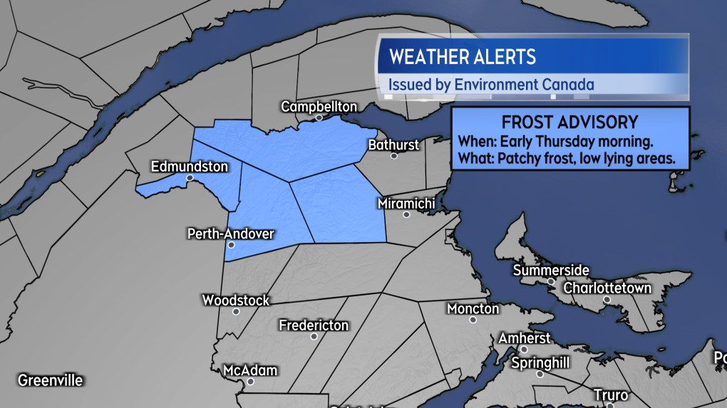
With clearer skies and low temperatures that could fall between 0 and 4 C, there is a risk of patchy frost in northwestern New Brunswick early Thursday morning and early Friday morning.
A Frost Advisory has been issued for early Thursday morning for the areas of Madawaska County, Restigouche County, Victoria County, and the Mount Carleton area. Environment Canada advises “patchy frost is expected to form as clear skies and light winds coincide with cool temperatures, especially in low lying areas.”
 A Frost Advisory issued for northwestern New Brunswick. Patchy frost possible by early Thursday morning. (Source: CTV News Atlantic)
If you have temperature-sensitive plants out that you can cover up or shelter, you may wish to consider doing so if you are in a community under the advisory. The risk of frost is higher in low-lying terrain, such as valleys or between hills. Low temperatures are forecasted to trend higher through the weekend into early next week, reducing the risk of frost.
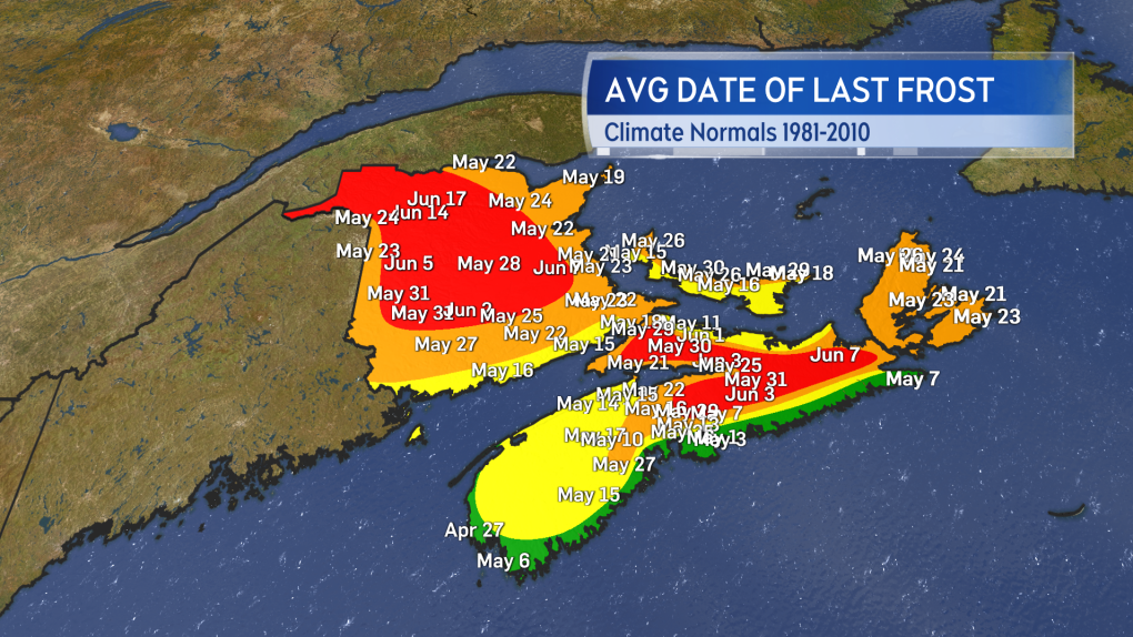
It isn’t too unusual to have a risk of frost in northwestern New Brunswick this time of year. Average climatological last dates of frost range from late May to early June for that part of the Maritimes. There have been a number of years where a frost has occurred further into the month of June.
 Climatological average last dates for frost around the Maritimes. (Source: CTV News Atlantic)
Tuesday rainfall
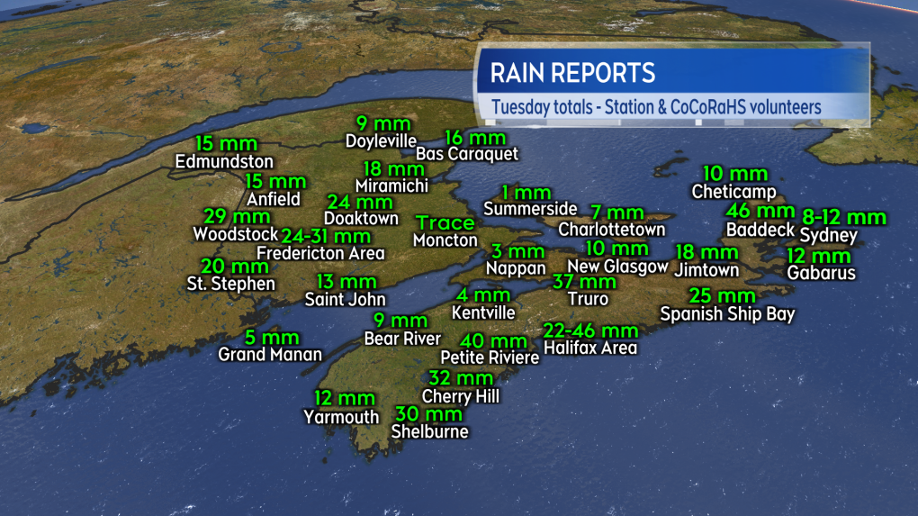
A case of have and have-nots for rain on Tuesday. Fairly widespread totals of 10-to-30 mm were reported in western New Brunswick and the Atlantic coastal counties of Nova Scotia. A few communities in Nova Scotia reached 30-to-50 mm as a result of downpours. Parts of eastern New Brunswick, northern mainland Nova Scotia, and Prince Edward Island finished with less than 10 mm of rain received.
 Tuesday rain reports from EC operated weather stations and the volunteer observer network at CoCoRaHS Canada. (Source: CTV News Atlantic)
The fire danger risk as evaluated by Natural Resources Canada has fallen into the low-to-moderate range for much of the Maritimes. The risk is still evaluated as being in the moderate-to-high range for Prince Edward Island and southeastern New Brunswick, two areas that didn’t receive as much rain. Not much more than a chance of some scattered showers moving through Friday and the weekend. Additionally drier air is expected to move in off the continent through that period of time. Be sure to check daily on provincial or municipal restrictions and guidelines before having an outdoor fire.
Shopping Trends
The Shopping Trends team is independent of the journalists at CTV News. We may earn a commission when you use our links to shop. Read about us.


CTVNews.ca Top Stories

BREAKING
BREAKING Prime Minister Trudeau to meet Donald Trump at Mar-a-Lago
Prime Minister Justin Trudeau has landed in West Palm Beach, Fla., on Friday evening to meet with U.S.-president elect Donald Trump, sources confirm to CTV News.
'Mayday! Mayday! Mayday!': Details emerge in Boeing 737 incident at Montreal airport
New details suggest that there were communication issues between the pilots of a charter flight and the control tower at Montreal's Mirabel airport when a Boeing 737 made an emergency landing on Wednesday.
Hit man offered $100,000 to kill Montreal crime reporter covering his trial
Political leaders and press freedom groups on Friday were left shell-shocked after Montreal news outlet La Presse revealed that a hit man had offered $100,000 to have one of its crime reporters assassinated.
Cucumbers sold in Ontario, other provinces recalled over possible salmonella contamination
A U.S. company is recalling cucumbers sold in Ontario and other Canadian provinces due to possible salmonella contamination.
John Herdman resigns as head coach of Toronto FC
John Herdman, embroiled in the drone-spying scandal that has dogged Canada Soccer, has resigned as coach of Toronto FC.
Musk joins Trump and family for Thanksgiving at Mar-a-Lago
Elon Musk had a seat at the family table for Thanksgiving dinner at Mar-a-Lago, joining President-elect Donald Trump, Melania Trump and their 18-year-old son.
Billboard apologizes to Taylor Swift for video snafu
Billboard put together a video of some of Swift’s achievements and used a clip from Kanye West’s music video for the song “Famous.”
Trudeau says no question Trump is serious on tariff threat
Prime Minister Justin Trudeau says incoming U.S. president Donald Trump's threats on tariffs should be taken seriously.
In a shock offensive, insurgents breach Syria's largest city for the first time since 2016
Insurgents breached Syria's largest city Friday and clashed with government forces for the first time since 2016, according to a war monitor and fighters, in a surprise attack that sent residents fleeing and added fresh uncertainty to a region reeling from multiple wars.
Toronto
-
 BREAKING
BREAKING Feds announce $758 million in funding for new Line 2 TTC subway trains
The TTC will get funding from the federal government to replace aging trains on Line 2, Deputy Prime Minister Chrystia Freeland has announced.
-
Highway 407 owner says no active buyback discussions with Ontario government
Pressure is increasing on the provincial government to tap into the underused tolled Highway 407 to unclog congestion on Highway 401.
-
Officer's inaccurate testimony 'will undoubtedly tarnish the image of the Toronto Police Service:' police tribunal
A Toronto cop who 'derailed' a criminal investigation by 'inaccurately' testifying that he saw drugs in plain view inside a suspect’s car has been demoted for two years after pleading guilty to discreditable conduct, a decision from the police tribunal read.
Calgary
-

Calgary fighters thankful to enter ring under safe conditions after Ultra Boxing event cancelled
A group of Calgary fighters are thankful to be able to enter the ring under a properly sanctioned event this weekend after the organization they were training under was suspended by Boxing Alberta for two years due to safety concerns.
-
Blue Jackets extend points streak to 5 games with a chippy 5-2 win over the Flames
Adam Fantilli scored twice and the Columbus Blue Jackets extended their points streak to five games with a 5-2 win over the Calgary Flames in a chippy game that included six fighting majors.
-
Calgary Mayor Jyoti Gondek running for re-election
Calgary Mayor Jyoti Gondek has announced she will run for re-election in the next municipal election in 2025.
Edmonton
-

Massage therapist charged in connection with sexual assault at Mill Woods clinic
An Edmonton massage therapist has been charged with sexual assault in connection with an incident earlier this year.
-
Armed convenience store robber sought by Edmonton police
Police are searching for the man who robbed a convenience store in southwest Edmonton last weekend.
-
Teenage boy accused of stealing $15K in merchandise from Alberta cannabis shop
A teenager is facing charges after thousands of dollars in merchandise was stolen from a cannabis store robbery east of Edmonton.
Montreal
-

Hit man offered $100,000 to kill Montreal crime reporter covering his trial
Political leaders and press freedom groups on Friday were left shell-shocked after Montreal news outlet La Presse revealed that a hit man had offered $100,000 to have one of its crime reporters assassinated.
-
Judge hears from ex-employees of Montreal billionaire Robert Miller in sex abuse lawsuit
A Quebec Superior Court justice will deliberate before deciding whether to authorize a class-action lawsuit against Quebec electronics billionaire Robert Miller, accused of paying minors for sex.
-
Santé Quebec launch brings uncertainty to province's health-care system
Sante Quebec is launching on Sunday amid concerns over budget cuts and the impact on services.
Ottawa
-

Ottawa shoppers head back to stores and malls for Black Friday
Black Friday shoppers in the nation's capital found themselves back among the crowds as the ongoing strike by postal workers threatened the arrival of holiday orders.
-
'We will always be a downtown store': Steve's Music Store moving from Rideau Street after 42 years
A staple of the Rideau Street corridor, Steve's Music Store, is packing up and moving out after 42 years in business. The store will not be closing, its manager says, but rather moving to a new location that is yet unannounced.
-
BREAKING
BREAKING Prime Minister Trudeau to meet Donald Trump at Mar-a-Lago
Prime Minister Justin Trudeau has landed in West Palm Beach, Fla., on Friday evening to meet with U.S.-president elect Donald Trump, sources confirm to CTV News.
London
-

Crown witness describes chaotic night after bush party shooting
Crown witness Reece Davidson, 21, told the jury that he was at the bush bash off of Pack Road in southwest London with a bunch of his young friends on July 30, 2021.
-
'The only thing you could see were his eyes': Employees pepper sprayed at south London business
Around 4 p.m. on Thursday, police were called to a report of an assault in progress at a business int he 600 block of Wilkins St. near Wellington Road.
-
$20 million investment from WSIB to help Fanshawe College prepare up and coming first responders for mental stress
Fanshawe College and the Workplace Safety Insurance Board (WSIB) have announced a $20 million investment from WSIB to establish the WSIB Centre of Excellence in Immersive Technologies and Simulation for Workplace Safety. It is the largest single research grant in Fanshawe’s history.
Barrie
-

Jury delivers verdict in Midland landlord's second-degree murder case
The Midland man facing second-degree murder for the death of his tenant in 2021 was found not guilty on Friday.
-
Former Ont. teacher charged with sexually assaulting a teen nearly 50 years ago
A senior from Clearview Township faces charges in connection with an investigation into a sexual assault involving a teen nearly 50 years ago.
-
Alleged mastermind behind Ontario woman's presumed death seeks bail
The man facing first-degree murder and kidnapping charges in the disappearance of Ontario woman Elnaz Hajtamiri took another shot at bail on Friday in a Barrie courtroom. Mohamad Lilo, 37, has been behind bars since his arrest more than two years ago.
Northern Ontario
-

Man fined $10K for abandoning homemade barge in Lake Nipissing
A man from Lavigne, Ont., has been fined $10,000 for abandoning a homemade barge in Lake Nipissing.
-
Another 60 cm of snow possible in the Sault as severe weather continues
Closures and cancellations are piling up in Sault Ste. Marie as a major winter storm continues for another day Friday.
-
Heavy police presence on road in Iroquois Falls
Members of the public are being asked to avoid the area of Nellie Lake Road West in Iroquois Falls.
Kitchener
-

Family of Guelph, Ont. man killed in B.C. crash pushing for case review
The family of a Guelph, Ont. man who was killed in a car crash in British Columbia is pushing for a review of the case, after learning about the charge that a driver involved is now facing.
-
Erick Buhr to represent himself during sentencing for second-degree murder in death of his grandmother, Viola Erb
Erick Buhr will represent himself as he prepares for sentencing after being convicted of second-degree murder in the death of his grandmother, Viola Erb.
-
Region of Waterloo considers reducing, and even cutting, some services to keep tax increase down
The Region of Waterloo is considering reducing or eliminating some services in an effort to lower the potential 2025 tax increase.
Windsor
-
 Breaking
Breaking Guilty on all counts: Windsor man convicted of careless driving in Retrofest double fatal collision
The Windsor man charged in connection to the double fatal Retrofest collision has been convicted on all counts.
-
'All the indicators are fantastic': Devonshire Mall braces for record breaking crowds this Black Friday weekend
Thousands of shoppers are expected to head to Devonshire Mall in full force this weekend in search of holiday savings and the best Black Friday deals.
-
Model railroad program inspiring next generation
Model railroading is a popular hobby. It can be as simple as a train on a small oval track or a complex rail system with detailed scenery.
Winnipeg
-

True North officially buys Portage Place Mall
True North Real Estate Development (TNRED) has officially purchased Portage Place Mall.
-
Manitoba Metis Federation to be first Metis group with modern treaty with Canada
The Manitoba Metis Federation will be the first Metis group to sign a modern treaty with the federal government.
-
Family says B.C. man's cremated remains in limbo due to Canada Post strike
A Quebec woman whose father died in British Columbia last month says her family has been unable to properly grieve because the Canada Post strike has left his remains in limbo.
Regina
-

Regina's LED volume wall leaving Sask. months after opening
Less than a year after an LED volume wall was introduced to the film world in Saskatchewan, the equipment is making its exit from the province.
-
Sask. NDP says Scott Moe, staff stayed in Toronto hotel at rate over $800 per night
The Saskatchewan NDP says Premier Scott Moe and three Saskatchewan Party staff members stayed at a hotel in Toronto last June that cost each of them $818.74 per night for a three-night stay.
-
Jury sequestered to find verdict in sexual assault trial against Regina chiropractor
Justice Janet McMurtry sequestered a 12-person jury to determine a verdict against Regina-based chiropractor Ruben Manz.
Saskatoon
-

'A huge value addition': Sask. scientists develop way to make canola meal more profitable
Researchers at the University of Saskatchewan are looking at making the canola crop more profitable.
-
Missing 60-year-old Sask. man found dead
The Saskatchewan RCMP says 60-year-old Clayton Cameron, reported missing earlier this week, has been found dead.
-
Alberta man dies in crash with semi on Sask. highway
A 61-year-old Alberta man has died following a two-vehicle crash on Highway 14 near Landis on Thursday.
Vancouver
-

Suspect arrested after tense incident near Surrey school, police say
Police in Surrey say they called in the heavily armed Emergency Response Team to arrest a man who allegedly had a gun Friday morning.
-
Study of 2023 Okanagan wildfires recommends limiting development in high-risk areas
A study into the devastating wildfires that struck British Columbia's Okanagan region in 2023 has recommended that government and industry limit development in high-fire-risk areas.
-
Man facing 10 charges after Richmond, B.C., crime spree
A Metro Vancouver man has been charged with nine counts of breaking and entering and one count of mischief after a five-day crime spree last November.
Vancouver Island
-

Supreme Court clears way for B.C. to include other governments in opioid lawsuit
B.C. Attorney General Niki Sharma says a Supreme Court of Canada victory has cleared a "pathway" for governments across the country to go after opioid makers and distributors for damages arising from the opioid crisis.
-
Study of 2023 Okanagan wildfires recommends limiting development in high-risk areas
A study into the devastating wildfires that struck British Columbia's Okanagan region in 2023 has recommended that government and industry limit development in high-fire-risk areas.
-
How changing catch-and-release fishing practices can boost salmon survival
A study has found catch-and-release sportfishing practices that leave salmon with injuries, particularly to their eyes, cause higher mortality than earlier research suggested.
Kelowna
-

Study of 2023 Okanagan wildfires recommends limiting development in high-risk areas
A study into the devastating wildfires that struck British Columbia's Okanagan region in 2023 has recommended that government and industry limit development in high-fire-risk areas.
-
Kelowna, B.C., to host the Memorial Cup in the spring of 2026
The Western Hockey League's Kelowna Rockets will host the Memorial Cup in the spring of 2026, the Canadian Hockey League said Wednesday.
-
545 vehicles impounded in 332 days: BC Highway Patrol pleads for drivers to slow down
Mounties with the BC Highway Patrol in Kelowna say they've impounded more than 545 vehicles for excessive speed and aggressive driving so far this year. That works out to more than 1.6 per day.


