Helene reaches hurricane strength; landfall expected in Florida Thursday
Per the 11 a.m. EDT update from the National Hurricane Center, Helene has become a category-one hurricane with maximum sustained winds near 130 km/h. The hurricane force winds were confirmed by Air Force Reserve and NOAA Hurricane Hunter aircraft. The storm is positioned 135 km to the northeast of Cozumel, Mexico as it moves into the Gulf of Mexico.
Rapid strengthening to a major hurricane
The storm is moving into very favourable conditions for further intensification. Sea surface temperatures ahead of the hurricane are near 30 degrees and the wind environment over the Gulf of Mexico isn’t expected to be strong enough to disrupt the storm. Hurricanes need sea surface temperatures of just over 27 degrees to fuel them.
Helene is forecast to become a category-three hurricane Thursday morning with maximum sustained winds near 195 km/h. The strongest winds near the centre of the storm are then expected to reach 205 km/h just before landfall, which is projected to be on the Florida panhandle Thursday night. Once inland, the storm will eventually weaken to a tropical storm and then post-tropical area of low pressure.
Category-three hurricanes are capable of extensive structural damage to buildings near the landfall location both as a result of the extreme wind and storm surge. They can uproot a large number of trees and the damage done to utilities can take several weeks to recover from.
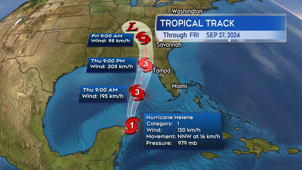 The forecast intensity and cone for the storm from the late Wednesday morning update of the National Hurricane Center. (Source: CTV News Atlantic)
Hurricane warnings
Hurricane Warnings have been issued in Florida from just north of Tampa to Apalachicola on the Florida Panhandle. The Hurricane Warnings also extend into southern Georgia. Much of the remainder of Florida is under a Tropical Storm Warning.
Hurricane and tropical storm warnings are issued when those conditions are expected within 36 hours.
A Tropical Storm Watch extends across the state of Georgia and into parts of the Carolinas as well as eastern Tennessee. Tropical storm watches are issued for areas where tropical storm conditions are possible within 48 hours.
Residents under warnings are being advised to complete preparations by or before early Thursday.
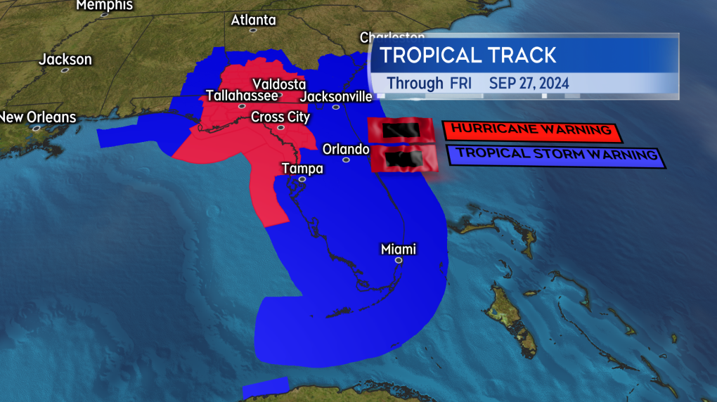 Hurricane and Tropical Storm Warnings issued by the National Hurricane Center and National Weather Service. (Source: CTV News Atlantic)
Life-threatening storm surge and rain
The worst of the storm surge is expected to be along the Florida Big Bend coastline. The National Hurricane Center cautions “there is a danger of life-threatening storm surge” and the highest inundation of water may be greater than 10 feet or three metres.
Torrential rain is expected to impact a larger area of the southeastern United States. Indications are for a risk of rain amounts ranging from 100-to-300 mm beginning on the Florida Panhandle and extending north through the state of Georgia and into parts of the Carolinas and Tennessee. Eastern areas of the state of Alabama are also at risk of rain totals exceeding 100 mm. That amount of rain will bring a risk of flash and urban flooding.
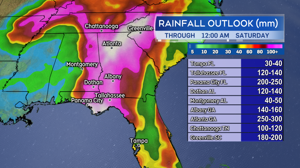 A swath of flooding rain is expected through western Florida, Georgia, and for parts of Alabama, the Carolinas, and Tennessee. (Source: CTV News Atlantic)
Bands of thunderstorms brought in by the hurricane are also likely to produce isolated, brief tornadoes.


CTVNews.ca Top Stories

BREAKING
BREAKING PM Trudeau's Liberal government survives first confidence vote of the fall
Prime Minister Justin Trudeau has survived his first confidence vote of the fall sitting. Members of Parliament voted on Conservative Leader Pierre Poilievre's attempt to bring down the Liberal government after question period on Wednesday, and the non-confidence motion was defeated.
'It is time to leave': Joly to meet with Lebanese PM amid Israel-Hezbollah conflict
Foreign Affairs Minister Mélanie Joly says she will meet with Lebanon's prime minister in New York on Saturday amid the escalating conflict between Israel and militant group Hezbollah in southern Lebanon.
'She was victimized by a predator': B.C. court reverses transfer of $1.4M townhouse in elder abuse case
A man who "systematically isolated, manipulated, deceived, abused, and exploited" an elderly North Vancouver woman has lost his ownership stake in her home.
Doug Ford says he wants to build a tunnel under Hwy. 401
Ontario Premier Doug Ford says he wants to build a tunnel under Highway 401 that would stretch from Brampton to Scarborough.
Yogurt recalled in Canada over risk of illness
A major yogurt maker is recalling one of its brands in Canada over concerns that it may cause illness in immunocompromised people.
Amadeus? Amadeus!: Lost childhood manuscript of Mozart discovered in Germany
Careful listeners of Mozart may notice an unfamiliar melody attributed to his childhood works in their streaming feeds this week.
1 in 3 children worldwide is now nearsighted, study shows
More than a third of children around the world were nearsighted in 2023, and this proportion will rise to almost 40 per cent in 2050, according to new research.
Mortgage changes: Cheaper entry into housing market at steeper costs
Mortgage rule changes allow easier entry into the housing market with lower monthly payments, but also an increased cost of repaying a mortgage.
Coverage denied: Canadians hitting roadblocks with insurers after installing solar panels on their homes
More Canadians are installing solar panels on their homes, but some are facing challenges when it comes to getting home insurance after the panels are put in.
Shopping Trends
The Shopping Trends team is independent of the journalists at CTV News. We may earn a commission when you use our links to shop. Read about us.


Toronto
-

Doug Ford says he wants to build a tunnel under Hwy. 401
Ontario Premier Doug Ford says he wants to build a tunnel under Highway 401 that would stretch from Brampton to Scarborough.
-
Thieves stole more than $2.2 million of merchandise from moving tractor trailers: police
Police have arrested one suspect and are looking for two others in connection with a rash of thefts in which thieves gained access to moving tractor trailers and stole more than $2.2 million in merchandise while the vehicles were stopped at red lights.
-
Toronto teachers’ union accuses Ford of diverting attention away from Grassy Narrows as province begins investigating controversial field trip
The union representing some elementary teachers in Toronto says Premier Doug Ford’s comments about a field trip highlighting the challenges facing a northern Ontario First Nation, which ended with students chanting pro-Palestinian slogans, are taking away from the plight of the impacted Indigenous Peoples.
Calgary
-

Unarmed suspect tackled, restrained by Calgary police, ASIRT says
A suspect who died while in police custody earlier this month was unarmed when he was tackled and punched by a group of Calgary officers, the province's police watchdog said Wednesday.
-
BREAKING
BREAKING PM Trudeau's Liberal government survives first confidence vote of the fall
Prime Minister Justin Trudeau has survived his first confidence vote of the fall sitting. Members of Parliament voted on Conservative Leader Pierre Poilievre's attempt to bring down the Liberal government after question period on Wednesday, and the non-confidence motion was defeated.
-
$500K in cocaine, meth seized during Calgary drug bust
Police seized more than $500,000 worth of cocaine and methamphetamine from a Calgary home during a recent search.
Edmonton
-

Attempted murder charge laid in assault at Wetaskiwin shelter
Charges have been laid in an incident that seriously injured a man at a shelter south of Edmonton last month.
-
More Indigenous participation in labour market would boost Alberta economy: Report
A new report says increasing Indigenous participation in Alberta's labour market could boost the province's GDP by between two and three percentage points, the equivalent of $8 billion to $11 billion annually.
-
Alberta bringing lung screening to rural and remote communities
The Alberta Cancer Foundation and the provincial government are working to expand lung screening services to remote and rural areas.
Montreal
-

Sound decision: Montreal to change bylaw to protect venues from noise complaints
The City of Montreal is promising to rapidly change a bylaw to protect entertainment venues and bars from noise complaints, after a court ordered a beloved music hall to pipe down.
-
Presidents Cup gridlock: Ile Bizard traffic chaos frustrates commuters
Even before the sun rose on Wednesday morning, the only bridge in and out of Ile Bizard was backed up both ways. The world’s top golfers are teeing off at the Presidents Cup this week. But the tournament is already causing chaos on the island, with commuters trapped in traffic, school drop-offs, and major deliveries disrupted.
-
Northvolt: how much is Quebec's investment now worth?
The opposition tried unsuccessfully on Wednesday to find out more about the state of public funds invested in Northvolt.
Ottawa
-

Ottawa Senator Claude Giroux's car stolen overnight
NHL star forward Claude Giroux had his car stolen in Ottawa on Tuesday evening, his wife says.
-
Shots fired at home in Carlington overnight
The Ottawa Police Service is investigating reports of gunfire in Ottawa's west end on Tuesday evening.
-
OPP confirm body found in Ottawa River was that of missing kayaker
Ontario Provincial Police have confirmed that a missing woman's body was recovered from the Ottawa River this past weekend, days after she went missing while kayaking.
London
-

LHSC Shakeup: Board resigns, province appoints David Musyj as supervisor
A statement from the province said Musyj will work closely with LHSC senior leadership and staff to address concerns regarding hospital governance and operations, and management practices, including concerning financial performance, that were found as a result of a third-party review.
-
Barn destroyed in Listowel area blaze
Fire crews from Listowel, Atwood, and Monkton battled the blaze on Line 81, which started around 5 p.m. Tuesday.
-
Meet Murphy, London’s newest K9 officer
The London Police Service (LPS) has announced their newest member of the Canine Unit, PSD Murphy.
Barrie
-

Mystery surrounds Corvette found stripped of parts on dirt road outside Barrie, Ont.
A bizarre discovery was made on a dirt road in Clearview Township.
-
One person in custody following incident near Barrie high school
Police in Barrie have one person in custody following an incident near St. Joseph's Catholic High School.
-
Here's when a new road in Barrie's south end will open to traffic
This week marks the opening of a new road in Barrie's south end, which is anticipated to help ease traffic congestion.
Northern Ontario
-

Tearful complainant alleges Jacob Hoggard raped, choked her after Hedley concert
GRAPHIC WARNING: A woman accusing Jacob Hoggard of sexual assault in northern Ontario told his trial the musician raped, hit and choked her before urinating on her in a hotel room after she attended his band's concert and an after-party eight years ago.
-
Trio charged after Cochrane police seize drugs, weapons
Raids of two residences in Cochrane on Tuesday yielded $25,000 in illegal drugs, firearms and $3,500 in cash.
-
Northern Ont. ATV driver charged with impaired, threatening to shoot 'all of the officers'
A 25-year-old suspect was charged with impaired driving Sept. 21 after police spotted two people without helmets on an ATV on Sand Bay Road in Goulais River.
Kitchener
-

Human suspected of being bit by rabies-positive bat from Brantford, Ont.
The Brant County Health Unit (BCHU) says it has its first case this year of suspected human exposure to an animal with rabies after a person was believed to be bit by a bat.
-
Couples, contractors claim they were scammed by Ontario wedding vendor
Newlyweds claim the company they hired to take their wedding photos and videos took off with their precious memories – and their money.
-
Residents raise concerns over proposed 44-storey tower at former CTV Kitchener station
The new tower would be built at the former longtime home of CTV Kitchener but people living on the quiet streets nearby say they need some questions answered first.
Windsor
-

Suspect arrested after pointing realistic airsoft gun: Windsor police
Windsor Police have arrested a 22-year-old man after he allegedly pointed a realistic airsoft gun at another person.
-
OPP investigating “incident involving wild turkeys” in Tecumseh
The Essex County OPP is investigating an incident involving wild turkeys in Tecumseh.
-
LHSC Shakeup: Board resigns, province appoints David Musyj as supervisor
A statement from the province said Musyj will work closely with LHSC senior leadership and staff to address concerns regarding hospital governance and operations, and management practices, including concerning financial performance, that were found as a result of a third-party review.
Winnipeg
-

Three dead, one hospitalized after crash on Manitoba highway
Three people are dead and one person is seriously injured after a two-vehicle collision on a Manitoba roadway.
-
Manitoba, First Nations group start recruiting workers to search landfill for remains
The Manitoba government and an advocacy group representing First Nations have started the process of hiring workers to help search a landfill for the remains of two victims of a serial killer.
-
'Their stories are not forgotten': Monument unveiled to remember victims of 1972 Winnipeg plane crash
A new monument honouring the victims of a plane crash in Winnipeg in 1972 was unveiled Wednesday afternoon.
Regina
-

Sask. Education Minister Jeremy Cockrill under second conflict of interest investigation
Minister of Education Jeremy Cockrill is facing a second investigation by the province's Conflict of Interest Commissioner (COIC) – this time concerning investments into helium companies that have held government contracts.
-
'Felt trapped': In Sask. human trafficking trial, court hears woman forced into sex with employer
In a human trafficking trial Tuesday, a Bangladeshi woman says she was sexually assaulted nearly two years ago during her time working at a small-town Saskatchewan restaurant.
-
Man facing murder charge in relation to death of Peepeekisis Cree Nation woman
RCMP and File Hills Police Service say a man has been charged with second degree murder in relation to a suspicious death on Okanese First Nation early Tuesday morning.
Saskatoon
-

'Felt trapped': In Sask. human trafficking trial, court hears woman forced into sex with employer
In a human trafficking trial Tuesday, a Bangladeshi woman says she was sexually assaulted nearly two years ago during her time working at a small-town Saskatchewan restaurant.
-
Canadian school photo company says hackers held Sask. students' pictures for ransom
A Canadian school photography company says it was hit by a ransomware attack that held about 3,500 photos of students in several Saskatchewan school divisions hostage, among others across the country.
-
'The building is a total loss': Fire destroys main portion of Sask. golf resort clubhouse
The Resort Village of Candle Lake says the devastating Monday morning fire has completely destroyed a portion of the Candle Lake Golf Course clubhouse.
Vancouver
-

B.C. helicopter pilot sick with fever in days before fatal crash, report finds
The Transportation Safety Board says a helicopter pilot killed in a crash in British Columbia almost two years ago was sick in the days leading up to the accident and reported "shivering uncontrollably" before the aircraft went down.
-
Atmospheric rivers deluge parts of B.C. as storm season begins
A series of atmospheric rivers has been moving across British Columbia's north and central coasts and spreading into the Interior.
-
Guns, drugs, explosives seized from 'fortified' residence in Surrey, B.C.
Mounties have seized nearly two dozen guns and several kilograms of explosives following a pair of searches at what police described as a "fortified" residence above a business in Surrey, B.C.
Vancouver Island
-

Atmospheric rivers deluge parts of B.C. as storm season begins
A series of atmospheric rivers has been moving across British Columbia's north and central coasts and spreading into the Interior.
-
BC NDP promises to finance portion of thousands of new homes if re-elected
British Columbia's New Democrats have unveiled a plan that Leader David Eby says will help middle-income families purchase a home by financing 40 per cent of the price.
-
More than two dozen gun, drug charges laid against 4 in Metro Vancouver
Mounties say two men and two women were charged with more than two dozen drug and weapons offences this summer following a year-long investigation into a Metro Vancouver drug-trafficking ring.
Kelowna
-

'Don't know where the animals came from': Runaway pigs rounded up in West Kelowna, B.C.
A pair of runaway pigs are in the custody of an animal sanctuary in the Okanagan after evading police and volunteers for hours earlier this week.
-
Video shows historic bridge in Kamloops, B.C., collapsing after fire
The Red Bridge, a historic landmark in Kamloops, B.C., was completely destroyed by fire early Thursday morning.
-
Pregnant pit bull with 10 puppies rescued from rat-infested B.C. home
Animal protection officers in British Columbia have rescued three pit bulls – including one that gave birth to 10 puppies – from a rat-infested home in Kelowna.


