Say it isn't snow! First snowfall warning of the season issued in the Maritimes
Nearly a month earlier than last year, we have our first snowfall warning of the season issued in the Maritimes.
Snowfall accumulating in Cape Breton
Cold air aloft of the relatively warmer waters of the Gulf of St. Lawrence is creating its own small weather system on Monday.
Moist air off the ocean waters is being lifted into the cold air above where it condenses and develops into snow. The bands of snow are then brought onshore into Cape Breton by a prevailing westerly wind. The additional lift created by the Highlands then causes more snow to fall at the higher elevations.
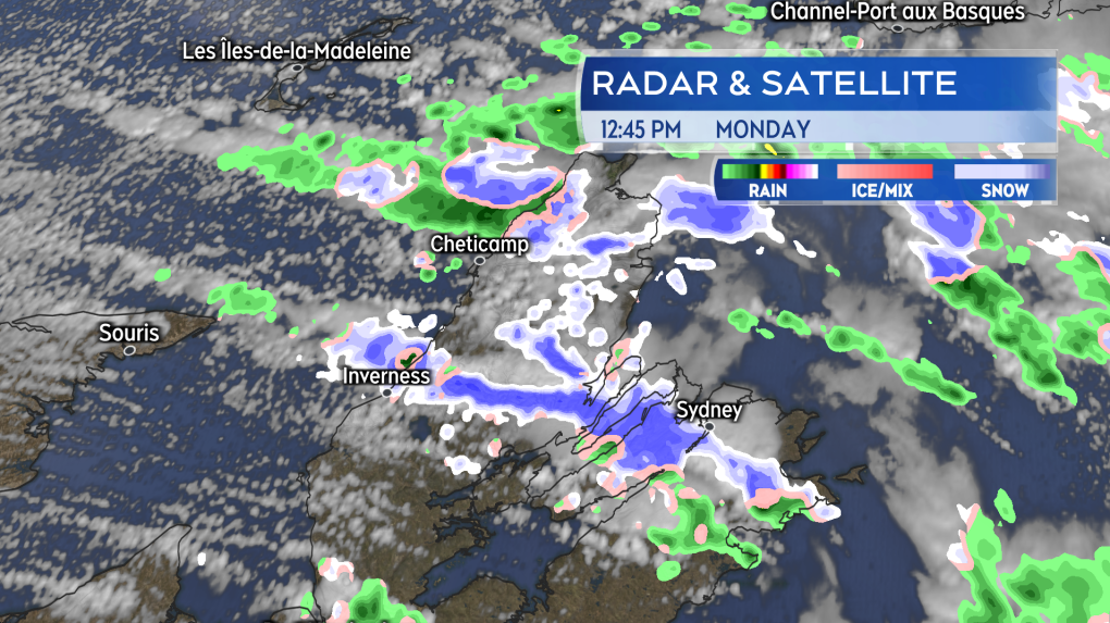 Bands of snow developing over the Gulf of St. Lawrence before moving into Cape Breton. This continues Monday and Monday night. (Source: CTV News Atlantic)
A Snowfall Warning issued by Environment Canada call for 15-to-25 cm of snow to fall in the Highlands Monday though Monday night. Any drivers using the Cabot Trail should anticipate there may be some snowy or slushy accumulation on road surfaces climbing in elevation. Visibility may also be reduced in falling snow. Just after noon on Monday, an automated weather station located at North Mountain reported four centimetres of snow on the ground.
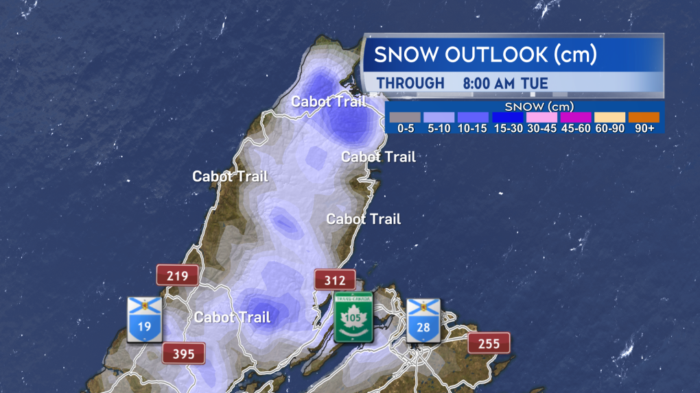 Snow amounts of 15+ cm are being indicated as possible in some of the highest elevations of the Highlands. (Source: CTV News Atlantic)
Early snow this year
Last year the first snowfall warning for the Maritimes was issued on Nov. 22 for the southwest of New Brunswick, including areas from St. Stephen to Fredericton.
Mainland Nova Scotia had its first snowfall warning on Dec. 3. Northern Inverness County, Cape Breton had its first snowfall warning a day later on Dec. 4.
Prince Edward Island had its first snowfall warning (Prince and Queens counties) on Dec. 29.
Those dates were supplied by Ian Hubbard, meteorologist Environment and Climate Change Canada.
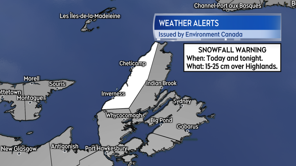 The first snowfall warning in the region coming almost and entire month earlier compared to last year. (Source: CTV News Atlantic)
Halloween weather more treat than trick
Are we going to be layering up for Halloween this year? Probably not.
The Maritimes continues to look like it will thread the needle when it comes to some pretty ideal weather conditions for Halloween this year.
On Thursday the region will be located in the “warm sector” of a low-pressure system crossing northern Quebec. That part of the weather system is generally characterized by partly cloudy conditions, low precipitation chances, and a steady southerly wind. There may be a low chance of showers in northern New Brunswick.
The southerly wind will boost temperatures on Thursday. Afternoon high temperatures may reach the high-teens to low-twenties. Evening temperatures held in the low-to-mid teens. While I would describe the wind as blustery at times, it doesn’t look strong. Sustained near 20 km/h with gusts near 40 km/h for most.
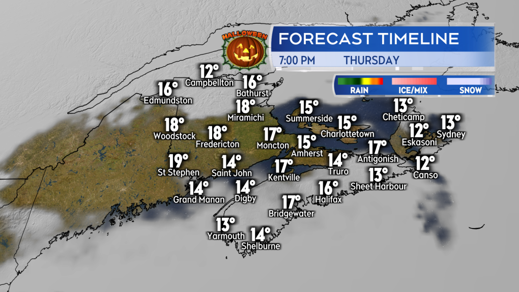 Halloween evening characterized by partly cloudy sky, mild temperatures, and a steady southerly wind this year. (Source: CTV News Atlantic)


CTVNews.ca Top Stories

Alleged assassination plot against Irwin Cotler by Iranian agents foiled by law enforcement
Iranian agents allegedly plotted to assassinate Canadian human rights advocate and former Liberal justice minister Irwin Cotler, a longtime vocal critic of Iran. Details of the foiled plot were first reported by The Globe and Mail citing unnamed sources on Monday and confirmed to CTV News by Cotler's office.
Some Canada-U.S. border crossing times will change in 2025. Here's what you need to know
The Canada Border Services Agency (CBSA) says it will adjust the opening hours of crossing points across the country early next year.
Parts of Canada will see up to 30 centimetres of snow. Here's where
Canadians are bracing for a chilly start to the week as snowfall and other wintry conditions are expected to make landfall across western and eastern provinces.
Halifax police say Walmart employee's death isn't suspicious, refuse to release details
Police in Halifax say the death of a Walmart employee who was found inside an oven in the store last month is not suspicious, but they are refusing to release any additional details.
'Bomb cyclone' developing off B.C. coast, potentially bringing hurricane-force winds
An Environment Canada meteorologist says a so-called "bomb cyclone" is expected to bring powerful winds to Vancouver Island and the British Columbia coast this week.
Canada Post, union to meet mediator Monday in effort to end strike
Canada Post and the Canadian Union of Postal Workers (CUPW) are meeting with a special mediator for the first time Monday to continue talks as they enter the fourth day of a national strike.
Israeli airstrike hits central Beirut near key government buildings and embassies
An Israeli airstrike late Monday slammed into a densely populated residential area in Lebanon's capital close to the UN headquarters, Parliament, the prime minister's office and several embassies.
Sean 'Diddy' Combs lawyers claim seizure of writings from cell is 'outrageous government conduct'
Lawyers for Sean ‘Diddy’ Combs accused prosecutors on Monday of engaging in “outrageous government conduct” by using materials seized from his jail cell to try to keep him incarcerated before a May trial.
Taylor Swift Eras Tour: Ticket scam west of Toronto costs 40 people more than $70K
Dozens of people in Halton Region are out tens of thousands of dollars after buying fake or nonexistent tickets to Taylor Swift’s Eras Tour dates in Toronto, police say.
Shopping Trends
The Shopping Trends team is independent of the journalists at CTV News. We may earn a commission when you use our links to shop. Read about us.


Toronto
-

Suspect charged in LCBO thefts totalling nearly $63,000: Peel police
A suspect is facing charges in connection with the theft of nearly $63,000 worth of items from various LCBO stores, Peel Regional Police say.
-
Ontario tables bill that bans supervised consumption sites near schools, daycares
Ontario has tabled a bill that aims to shutter 10 supervised consumption sites the government deems are too close to schools and daycares.
-
Stolen vehicle crashes into TTC bus in Toronto, 9 people injured
Nine people were injured, including two critically, after a stolen vehicle collided with a TTC bus in North York early Monday morning, Toronto police say.
Calgary
-

Snow-covered Calgary roads cause slow and slick Monday commute for drivers
Calgary drivers had a slow and slippery commute to and from work on Monday, thanks to a dump of snow.
-
Calgary family donates $30M to campaign for child cancer centre
A fundraising campaign wrapped up Monday for the recently opened Arthur J.E. Child Comprehensive Cancer Centre in Calgary, thanks in large part to a “monumental” donation from a local family.
-
High River couple can officially retire thanks to $2M win
A High River couple is celebrating a big lottery win that will help them retire.
Edmonton
-

New Alberta hospital agency to be up and running in the spring: minister
Alberta's health minister says the province's new hospital agency will be operational next spring, months later than expected.
-
RCMP searching for man in connection to 'suspicious' Wetaskiwin house fire
Wetaskiwin RCMP are searching for a 25-year-old in connection to a house fire on Nov. 7.
-
Owners of destroyed Jasper deli hope to return to reopen it
Wendy and Glen Leitch, with their daughter and son-in-law, hope to go back some day to open a replacement for the Patricia Street Deli, but not before they set up shop in Edmonton or another Alberta community.
Montreal
-

Eviction notices distributed in homeless encampment on Notre-Dame Street
Members of a homeless encampment on Notre-Dame Street in Mercier-Hochelaga-Maisonneuve have been given eviction notices by the Quebec government.
-
Quebec e-bus maker Lion Electric mulls sale of the company amid cash woes
Lion Electric Co. is opening the door to a possible sale of the company as the electric bus maker struggles to staunch an ongoing cash bleed.
-
Alleged assassination plot against Irwin Cotler by Iranian agents foiled by law enforcement
Iranian agents allegedly plotted to assassinate Canadian human rights advocate and former Liberal justice minister Irwin Cotler, a longtime vocal critic of Iran. Details of the foiled plot were first reported by The Globe and Mail citing unnamed sources on Monday and confirmed to CTV News by Cotler's office.
Ottawa
-

Sutcliffe 'working on a solution' to address blowback to proposed seniors transit fare hike
Ottawa Mayor Mark Sutcliffe is acknowledging negative feedback from the community regarding possible increases to transit fares for seniors and hinting the city could back down from the proposal.
-
'It's all caught up to us now': Low Canadian dollar hits locally owned grocery store
The Canadian dollar is at its lowest level since May 2020, with $1 CAD converting to $0.71 U.S. That means purchasing produce from the states is more expensive for Alfonso Curcio, the owner of Farmer’s Pick in Ottawa.
-
Ottawa family heartbroken after being scammed out of more than $22K on fake Taylor Swift tickets
A few weeks ago, they learned the tickets they booked last August were never real.
London
-

'200 Trees for 200 Years': Carolinian Forest constructed on Port Stanley, Ont. waterfront
The first grove has been created for the home of a new Carolinian Forest on the berm in Port Stanley, Ont.
-
'Landing place for young people': New Community Youth Hub unveiled at London Health Sciences Centre
Located at the London Health Sciences Centre Victoria Hospital, LHSC says the hub that is set to open Nov. 25, will offer vital support, resources and care to young Londoners living without housing.
-
Delays reported in London's yard waste collection
The City of London says its leaf and yard waste materials collection program is experiencing a delay due to an increase in the number of bags placed out.
Barrie
-

SIU clears Barrie officer after discharge of conducted energy weapon in the summer
The Special Investigations Unit found no reasonable grounds to believe a Barrie Police officer allegedly committed a criminal offence in connection with the serious injury of a 25-year-old man.
-
Collingwood’s tree lighting miss: Holiday blunder lights up social media
This year, Collingwood’s Christmas tree debuted Saturday with what some described as an underwhelming display, prompting both criticism and sympathy for the organizers.
-
Driver dies in collision with tree after vehicle bursts into flames
Provincial police are investigating a collision in Bracebridge that claimed the life of one person over the weekend.
Northern Ontario
-

School, daycare lockdown end in Kapuskasing following nearby police investigation
A Kapuskasing school and childcare centre lockdown ended Monday afternoon. It was prompted by a police investigation.
-
Rezoning application next step in redeveloping former hospital in Sudbury
Greater Sudbury's planning committee will vote Nov. 25 on a rezoning and official plan amendment for the former hospital in Sudbury, a key step in a major redevelopment of the Paris Street site.
-
Eight Sudbury school bus routes cancelled due to vandalism
Hundreds of Sudbury families are scrambling to find transportation for their children after eight school bus routes were cancelled Monday due to vandalism.
Kitchener
-

Arrest made after phone and internet lines cut to at least 18 Guelph businesses
A Guelph man has been charged after phone and internet cables for at least 18 Guelph businesses were cut last week.
-
Waterloo council deciding the fate of Eby Farmstead animal enclosure
Councillors for the City of Waterloo are set to vote on the future of Eby Farmstead after a staff report recommended its permanent closure.
-
Ray of Hope ends youth live-in treatment program, calls it 'unsustainable'
Ray of Home says it will no longer be offering its youth Live-In Treatment program.
Windsor
-

Walker Road closed near Wyandotte after 'very serious' crash
Windsor police have temporarily closed a section of Walker Road after a crash.
-
Talking to youth about grief and suicide: expert advice for parents
Discussing death is never easy, but when it comes to supporting a child or teenager through grief, the challenge can feel even greater.
-
Classes cancelled at University of Windsor
Classes at the University of Windsor have been cancelled Monday evening due to a power outage.
Winnipeg
-

Multiple Manitoba communities under winter storm warning
A winter storm is heading to western Manitoba this week.
-
'Maybe we can regenerate our own teeth': Manitoba scientists exploring abilities in tropical fish
Tropical fish hold clues that two Manitoba scientists believe could help unlock regenerative abilities in humans—like the ability to regrow your own teeth or repair your own brain following an injury.
-
'Devastating': Blue Bombers left stunned by third consecutive Grey Cup loss
Nick Demski sat slumped in his locker, staring off into space.
Regina
-

Teens charged after Regina woman assaulted, threatened with knife, gun in Uplands neighbourhood
Three teenagers have been charged for their alleged roles in an armed robbery in Regina's Uplands neighbourhood – with police saying a woman was assaulted and threatened with a knife and gun Friday.
-
These Saskatchewan border crossings are changing their hours of operation
The Canada Border Services Agency (CBSA) is changing the hours of six border crossings in Saskatchewan in the new year.
-
Regina's new mayor and council will be sworn in Monday night
Regina's newest mayor and iteration of city council will be sworn in Monday night at a ceremony at Henry Baker Hall.
Saskatoon
-

Saskatoon library workers heading back to the picket lines
Saskatoon’s city library workers are heading back to the picket lines for a second one-day strike on Tuesday.
-
Winter storm watch upgraded to warning for northeastern Sask.
A winter storm watch has been upgraded to a warning for parts of northeastern Saskatchewan, Environment and Climate Change Canada (ECCC) says. With as much as 30 centimetres of snow possible in some areas.
-
Sask. RCMP deploys body-worn cameras, but don't expect to see much of the video
Front-line RCMP officers in Saskatchewan are being issued body-worn cameras this month, as part of a nationwide effort to increase “transparency and accountability.”
Vancouver
-

B.C. Premier David Eby's new cabinet shifts Dix, Farnworth into new roles
B.C. Premier David Eby introduced his new cabinet Monday, with some notable shuffles in high-profile positions responsible for addressing some of the most pressing issues facing the province.
-
Man killed in group fight outside Surrey business
A man has died after being attacked during a large-scale fight in Surrey.
-
'Bomb cyclone' developing off B.C. coast, potentially bringing hurricane-force winds
An Environment Canada meteorologist says a so-called "bomb cyclone" is expected to bring powerful winds to Vancouver Island and the British Columbia coast this week.
Vancouver Island
-

'Saving lives is not controversial': B.C. doctors set up 'unsanctioned' overdose prevention sites at hospitals
A group of physicians are setting up unofficial overdose prevention sites outside two Vancouver Island hospitals Monday, aiming to help people struggling with addiction – while also sending a message to the government.
-
B.C. Premier David Eby's new cabinet shifts Dix, Farnworth into new roles
B.C. Premier David Eby introduced his new cabinet Monday, with some notable shuffles in high-profile positions responsible for addressing some of the most pressing issues facing the province.
-
B.C. man to cycle length of New Zealand to raise funds for Movember
Stretching 3,000 kilometres from the tip of New Zealand to its southernmost point, with just a bicycle for transport and a tent to call home, bikepacking event Tour Aotearoa is not for the faint of heart.
Kelowna
-

Man in hospital following targeted shooting in Kamloops
Police are appealing for information on a targeted shooting that resulted in the hospitalization of a man in Kamloops.
-
Police cleared of fault in fatal 2023 crash in B.C.'s Interior
British Columbia's independent police watchdog has cleared officers of wrongdoing in a crash where three people were killed south of Kamloops in July of last year.
-
B.C. woman sentenced for stealing $14K in funds raised for schoolkids
A B.C. woman who stole more than $14,000 in volunteer-raised funds that were supposed to be spent on school supplies and programs – including hot meals for vulnerable kids – won't spend any time in jail.


