HALIFAX -- A classic nor'easter winter storm is moving northward just off the eastern seaboard of the United States and will be affecting the Maritimes Tuesday into early Wednesday.
The storm will pack heavy snow, ice, rain, along with strong easterly winds.
TIMING
It looks as thought the storm will last approximately 24 hours for most communities. The snow reaches southwestern Nova Scotia and New Brunswick as early as 9 p.m. to midnight Monday. The snow will have filled in across mainland Nova Scotia as well as central and southern New Brunswick by 7 a.m. Tuesday morning. By noon, snow will have started in northern New Brunswick, Prince Edward Island, and Cape Breton.
Tuesday morning and afternoon will see mainland Nova Scotia turn through a period of ice pellets and over to rain. The snow-rain line will then push across southern New Brunswick, Prince Edward Island, and Cape Breton in the late afternoon and evening. Northern areas of New Brunswick can expect mixing in of ice pellets, freezing rain, and rain on Tuesday night.
The last of the steady precipitation will clear early Wednesday morning with some areas of showers and flurries lingering behind.
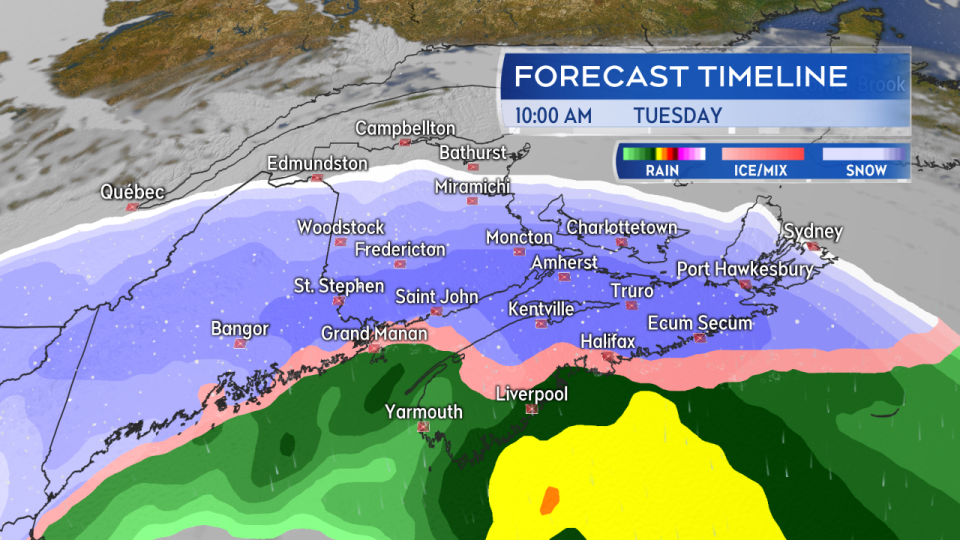
The system starts as snow for the region tonight and Tuesday morning. An eventual turn through a period of ice pellets/freezing rain to rain is forecast for Nova Scotia, PEI, and southern New Brunswick.
AMOUNTS
The highest snowfall totals look likely around Bathurst and the higher terrain in the northeast of New Brunswick. There the totals could reach as high as 25 to 40 cm. Much of the remainder of northern New Brunswick will likely clear 15 cm. Moncton and Fredericton look close to 15 cm with more mix expected. Amounts then taper lower towards the west and Bay of Fundy coastline.
Prince Edward Island and northern areas of Nova Scotia could hit 10 to 15 cm before a turn through ice pellets to rain. Summerside and western P.E.I. have a chance of clearing 15 cm. For the remainder of Nova Scotia, slippery accumulations of 5 to 10 cm of snow and ice pellets look likely before the rain takes over.
The rain will be heavy along the Atlantic coastline of Nova Scotia totalling as much as 40 to 70 mm. Localized flooding and hydroplaning conditions will be risks.
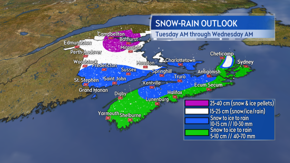
Given the mix of precipitation expected accumulation will be highly varied across the Maritimes. The heaviest snow looks to fall in northeastern New Brunswick with the Atlantic coastline of Nova Scotia seeing the most rain.
WIND
It will be an east and northeast wind to start Tuesday. The wind will turn east and southeast moving through the afternoon and evening.
Peak gusts of 70 to 100 km/h are expected for many coastal areas with inland gusts reaching 50 to 80 km/h. The strongest winds arrive in southwestern New Brunswick and Nova Scotia Tuesday morning, then shift eastward through the afternoon and arrive for P.E.I. and Cape Breton Tuesday evening and night.
Due to the topography of the Cape Breton Highlands gusts for Inverness County are likely to reach 140+ km/h Tuesday afternoon and night before gradually easing through Wednesday morning.
Typically, gusts as strong as are forecasted with this system are accompanied by a risk of power outages for the Maritimes.
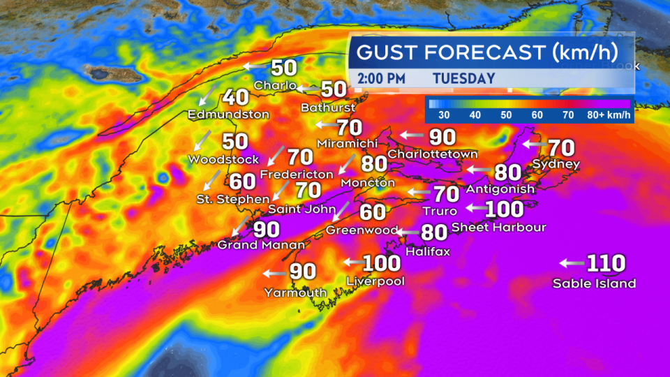
Strong winds will accompany the storm as it moves through. Initially east and northeast, they will turn southeast Tuesday afternoon and night. Coastal gusts peaking 80-100 km/h with widespread inland gusts 50-80 km/h. Inverness Co, Cape Breton with gusts in excess of 140 km/h in the forecast.
MARINE
A rough and pounding surf is expected to accompany the passage of the storm for our coastlines. The Atlantic coastline of Nova Scotia in particular could see higher than normal water levels particularly for the high tides Tuesday morning and night.
Gale and storm warnings have been issued for the marine districts with easterly winds 35 to 50 knots forecast to develop on Tuesday. Seas of 5 to 8 metres are forecast for Tuesday diminishing to 3 to 6 metres on Wednesday. Any operations in the marine districts should consult a more detailed forecast for their area of interest.
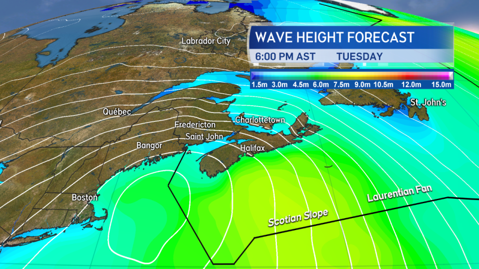
Gale and storm force winds are expected for the marine districts Tuesday. The seas building to a height of 5 to 8 metres.
A number of weather warnings including snow, rain, and wind have been issued ahead of the arrival of the storm by Environment Canada. I will have the latest on those, forecast timelines, and any required updates on CTV Atlantic News 5, 6, and 11:30 p.m.


