Snowfall warnings expanded in the Maritimes ahead of approaching snow
Environment Canada has expanded recent snowfall warnings into central New Brunswick, Prince Edward Island, and Cape Breton. Winter storm warnings have also been issued for Halifax County and Guysborough County in Nova Scotia.
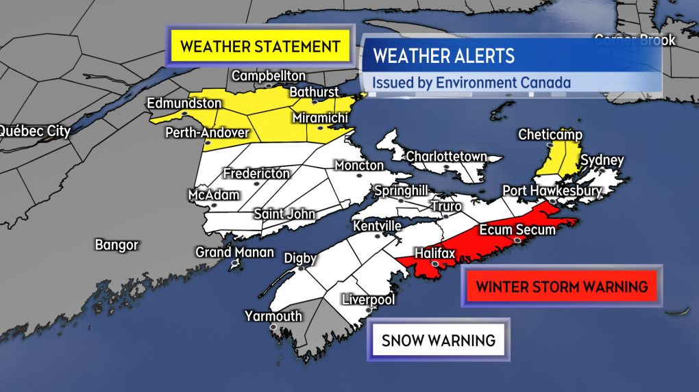 Snowfall warnings, winter storm warnings and special weather statements by Environment Canada are in effect.Snowfall warnings now blanket the southern half of New Brunswick, Prince Edward Island, and all of Nova Scotia, except Yarmouth and Shelburne Counties as well as northern Inverness and Victoria Counties in Cape Breton.
The warnings caution of some snow totals that could reach 15 to 30 cm. The highest snow totals are forecast for mainland Nova Scotia, with a general range of 20 to 30 cm. The government weather agency continues to note that, “snow will become heavy at times (Thursday) evening,” and “rapidly accumulating snow could make travel difficult over some locations. Visibility will be suddenly reduced to near zero at times in heavy snow and blowing snow.” Areas under the winter storm warning can not only expect snow totals of 20 to 30 cm, but also more prolonged periods of near whiteout conditions Thursday night as gustier winds develop.
Northern areas of New Brunswick are now under a special weather statement, with some snow totals of 10 to 15 cm possible. In Cape Breton, northern Inverness and Victoria Counties are also under a statement, with snow possibly reaching 15 cm by Friday morning. There is snowfall warning for Yarmouth and Shelburne Counties in the southwest of Nova Scotia due to the area expecting more rain and ice pellets to mix in.
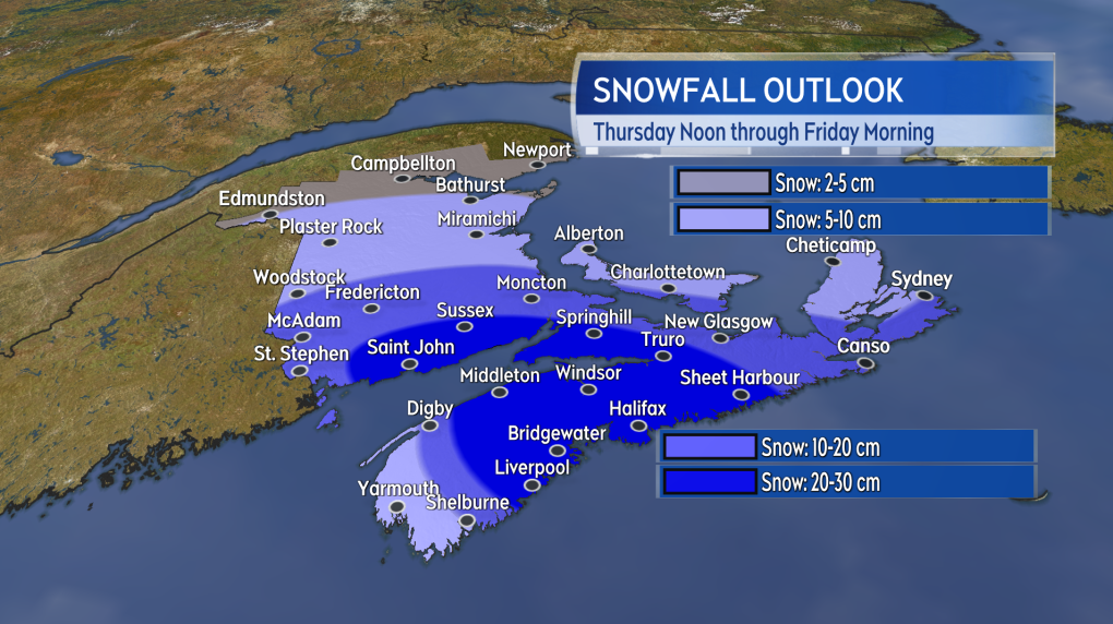 Forecasted snow amounts for the Maritimes, with lower amounts in the southwest of Nova Scotia due to the presence of rain and ice pellets.Snow is expected to be falling in western New Brunswick and southwestern Nova Scotia by early afternoon. The snow will reach eastern New Brunswick and central Nova Scotia by the start of the evening. Prince Edward Island and eastern Nova Scotia including Cape Breton will get into the snow late Thursday evening to midnight. The heaviest snow will clear the Maritimes west-to-east between 2 and 6 a.m. Friday. Areas of lighter snow and flurries are likely to linger in Halifax, eastern Nova Scotia and Prince Edward Island through the remainder of Friday morning.
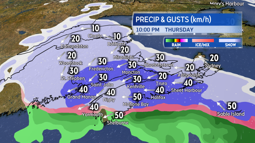
 The approximate progress of the start of the snow across the Maritimes moving into Thursday evening and night.An easterly wind turning northerly will accompany the falling snow. Peak gusts of 30 to 50 km/h are expected Thursday night into early Friday morning. Areas near the Atlantic coastline of Nova Scotia could reach gusts of 50 to 70 km/h. While below warning criteria, the gustier winds are expected to blow the snow around creating drifts and reducing visibility.
 Snow will be widespread in the Maritimes for Thursday night. Areas of heavier snowfall are shown in the darker shade of blue.The southwest of Nova Scotia should continue to monitor the Saturday forecast. Another low-pressure system is expected to move out of the northeastern U.S. and track south of the Maritimes. It is possible that the southwestern corner of Nova Scotia ends up with another 15 cm snowfall on Saturday.
There will be live updates on the latest position of the snow, timelines, and expected snow amounts on CTV News Atlantic programming at 5, 6, and 11:30 p.m.
Shopping Trends
The Shopping Trends team is independent of the journalists at CTV News. We may earn a commission when you use our links to shop. Read about us.


CTVNews.ca Top Stories

Mark Carney reaches out to dozens of Liberal MPs ahead of potential leadership campaign
Mark Carney, the former Bank of Canada and Bank of England governor, is actively considering running in a potential Liberal party leadership race should Justin Trudeau resign, sources tell CTV News.
'I gave them a call, they didn't pick up': Canadian furniture store appears to have gone out of business
Canadian furniture company Wazo Furniture, which has locations in Toronto and Montreal, appears to have gone out of business. CTV News Toronto has been hearing from customers who were shocked to find out after paying in advance for orders over the past few months.
WATCH
WATCH Woman critically injured in explosive Ottawa crash caught on camera
Dashcam footage sent to CTV News shows a vehicle travelling at a high rate of speed in the wrong direction before striking and damaging a hydro pole.
A year after his son overdosed, a Montreal father feels more prevention work is needed
New data shows opioid-related deaths and hospitalizations are down in Canada, but provincial data paints a different picture. In Quebec, drug related deaths jumped 30 per cent in the first half of 2024, according to the public health institute (INSPQ).
Much of Canada is under a weather alert this weekend: here's what to know
From snow, to high winds, to extreme cold, much of Canada is under a severe weather alert this weekend. Here's what to expect in your region.
Jimmy Carter's funeral begins by tracing 100 years from rural Georgia to the world stage
Jimmy Carter 's extended public farewell began Saturday in Georgia, with the 39th U.S. president’s flag-draped casket tracing his long arc from the Depression-era South and family farming business to the pinnacle of American political power and decades as a global humanitarian.
Jeff Baena, writer, director and husband of Aubrey Plaza, dead at 47
Jeff Baena, a writer and director whose credits include 'Life After Beth' and 'The Little Hours,' has died, according to the Los Angeles County Medical Examiner.
Hundreds of animals killed in Dallas shopping centre fire
A fire that broke out at a shopping center in Dallas on Friday morning killed more than 500 animals, most of which were small birds, authorities said.
MP Peter Fragiskatos calls on Trudeau to resign
Prime Minister Justin Trudeau has lost the confidence of another prominent Liberal MP.
Toronto
-

Police search for suspects after jewelry store robbery at Burlington mall
Police are searching for multiple suspects following a smash-and-grab robbery at a mall jewelry store in Burlington Saturday afternoon.
-
'Ambassadors for their species in the wild': Toronto Zoo loses 2 long-term residents
Toronto Zoo has bid goodbye to two of its long-term residents over the past week.
-
'I gave them a call, they didn't pick up': Canadian furniture store appears to have gone out of business
Canadian furniture company Wazo Furniture, which has locations in Toronto and Montreal, appears to have gone out of business. CTV News Toronto has been hearing from customers who were shocked to find out after paying in advance for orders over the past few months.
Calgary
-

Community grieves as one at vigil for Calgary double homicide victims
They braved the cold to pay tribute to a Calgary mother of three and her father, killed just days after Christmas.
-
Extreme cold warnings expanded across country; snowfall warnings remain for southern Alberta
A persistent weather pattern is funnelling arctic air across the Prairies, which forced Environment and Climate Change Canada (ECCC) to issue extreme cold warnings late Thursday.
-
Threat made to Lethbridge casino deemed to be a ‘swatting’ hoax: police
Investigators with Lethbridge police determined that a threat made to a local casino Thursday night was deemed to be a ‘swatting’ hoax.
Edmonton
-

'Flames were shooting higher than the garage': Block heater cords cause 2 fires in 2 days in Edmonton
Peter Claffey was shocked Thursday morning to find his truck in flames outside his southwest Edmonton home.
-
Declining volunteers increasing risk to rural municipalities: report
Plummeting numbers of volunteers have led to a crisis that threatens the sustainability of rural communities.
-
Who are Canada's top-earning CEOs and how much do they make?
Canada's 100 highest-paid CEOs earned $13.2 million on average in 2023 from salaries, bonuses and other compensation, according to the Canadian Centre for Policy Alternatives.
Montreal
-

A year after his son overdosed, a Montreal father feels more prevention work is needed
New data shows opioid-related deaths and hospitalizations are down in Canada, but provincial data paints a different picture. In Quebec, drug related deaths jumped 30 per cent in the first half of 2024, according to the public health institute (INSPQ).
-
CTV News Montreal at 6 p.m. for Saturday, Jan. 4, 2025
Watch CTV News Montreal at Six on Saturday, Jan. 4, 2025 with anchor Matt Grillo.
-
Here are the locations of the latest Quebec measles outbreak
Quebec public health confirmed that officials are monitoring a measles outbreak that began in December in Montreal, Laval and the Laurentians.
Ottawa
-
 WATCH
WATCHWATCH Woman critically injured in explosive Ottawa crash caught on camera
Dashcam footage sent to CTV News shows a vehicle travelling at a high rate of speed in the wrong direction before striking and damaging a hydro pole.
-
Rideau Canal Skateway opening 'looking very positive'
As the first cold snap of 2025 settles in across Ottawa, there is optimism that the Rideau Canal Skateway will be able to open soon.
-
Pedestrian, 15, killed in South Frontenac collision with van
Ontario Provincial Police are investigating after teenager was struck and killed by a van in a rural area north of Kingston on Saturday afternoon.
London
-

MP Peter Fragiskatos calls on Trudeau to resign
Prime Minister Justin Trudeau has lost the confidence of another prominent Liberal MP.
-
Poor weather postpones OHL Games in Owen Sound and Barrie
Inclement weather and travel conditions have forced the postponement of two games in the Ontario Hockey League Saturday.
-
Buffalo Bills legend Thurman Thomas among celebrities coming to St. Thomas, Ont.
The annual St. Thomas Sports Sports Spectacular presented by Hydro One has landed another superstar for the annual event later this month.
Barrie
-

Barrie declares significant weather event
The City of Barrie has declared a significant weather event on Saturday in response to the persistent snowfall in the area.
-
OHL game postponed due to weather
With the City of Barrie under a significant weather event declaration, Saturday evening’s Barrie Colts versus Kingston Frontenacs game at Sadlon Arena has been postponed.
-
‘Serious’ snowmobile crash under investigation
Police are investigating what is being deemed as a ‘serious’ snowmobile crash in Tay Township Saturday afternoon.
Northern Ontario
-

Suspect charged in northern Ont. road rage incident that went viral
A 37-year-old suspect has been charged in connection with a road rage incident last week in Temiskaming Shores.
-
Mark Carney reaches out to dozens of Liberal MPs ahead of potential leadership campaign
Mark Carney, the former Bank of Canada and Bank of England governor, is actively considering running in a potential Liberal party leadership race should Justin Trudeau resign, sources tell CTV News.
-
Sault, Ont., man claims Indigenous moose hunting rights without proof, fined $5,500
A hunter from Sault Ste. Marie, Ont., has been fined for moose hunting without a licence or proper documentation. He claimed Indigenous hunting rights but failed to provide any proof.
Kitchener
-

Police urging drivers to stay off the roads in Perth County
The Ontario Provincial Police are asking drivers to think twice before hitting the roads.
-
Three school board trustees call for town hall following director of education's departure
Three Waterloo Region District School Board trustees are joining the call for a town hall after a sudden shake up within the board.
-
Snow squall warnings for southwestern Ontario
Environment Canada says southwestern Ontario could get between 15 and 60 centimetres of snow by Saturday.
Windsor
-

Windsor fighter Randi Field signs to newly established MMA league
After a fight in March 2023, Windsor MMA fighter Randi Field feared a long list of injuries would derail her career.
-
MP Peter Fragiskatos calls on Trudeau to resign
Prime Minister Justin Trudeau has lost the confidence of another prominent Liberal MP.
-
Windsor Public Library hours changing Sunday
The hours of operation at the Windsor Public Library are changing on Sunday.
Winnipeg
-

'A really powerful day': Commemorating National Ribbon Skirt Day in Winnipeg
Dozens donned colourful fabrics and patterns Saturday in honour of the third-annual National Ribbon Skirt Day celebrated across the country.
-
Vacant apartment building demolished after third fire in 2 years
A vacant three-storey apartment building on Mountain Avenue has been demolished after its third fire since 2023.
-
Manitoba's top baby names for 2024
Manitoba’s top baby names remained mostly unchanged for 2024, though some new contenders made their way into the top 10.
Regina
-

Family of man shot by Hamilton police hold vigil and rally in Regina
The family and community of a man shot by police in Hamilton in November continue to seek answers surrounding the circumstances of his death.
-
Regina woman turns to social media to find donor match for kidney transplant
A Regina woman currently waiting for a kidney transplant is now seeking a donor through a social media post.
-
Much of Canada is under a weather alert this weekend: here's what to know
From snow, to high winds, to extreme cold, much of Canada is under a severe weather alert this weekend. Here's what to expect in your region.
Saskatoon
-

Extreme cold warning remains in effect for parts of Saskatchewan
The frigid weather continues to grip Saskatoon and parts of Saskatchewan as the extreme cold warnings are in effect across the prairies.
-
$20k of equipment stolen from rural Sask. Fire hall. And it's not the only one
Rural firehalls surrounding Saskatoon are having to deal with escalating thefts that could put rescue efforts in jeopardy.
-
Two people charged with murder after suspicious death on Sask. First Nation
A man and a woman have been charged with first degree murder after a 24-year-old man died of injuries on Saulteaux First Nation.
Vancouver
-

Body found in burned vehicle in Abbotsford park, police say
Homicide investigators have been called in to probe a suspicious death in Sumas Mountain Regional Park outside Abbotsford, police say.
-
Vancouver's Bloedel Conservatory welcomes visitors after months-long closure
After closing for just over two months for upgrades, Vancouver’s Bloedel Conservatory re-opened its doors the public Saturday.
-
Driver dead after collision with construction vehicle in Saanich, B.C.
A driver is dead after colliding with a construction vehicle in Saanich Friday night.
Vancouver Island
-

Driver dead after collision with construction vehicle in Saanich, B.C.
A driver is dead after colliding with a construction vehicle in Saanich Friday night.
-
WestJet denies compensation to Taylor Swift fan after flight cancellation
WestJet has denied compensation to a devout Taylor Swift fan whose cancelled flight triggered a 10-hour drive through the night from Prince George to make the singer's shows in Vancouver last month.
-
B.C. driver who tried to apprehend suspected impaired driver was impaired: RCMP
Mounties on Vancouver Island say a 50-year-old motorist who tried to apprehend a suspected impaired driver on New Year's Eve, was, in fact, impaired and was issued a 90-day driving prohibition by police.
Kelowna
-

Lost skiers rescued off B.C. mountain
Search and rescue volunteers in B.C.’s Okanagan successfully reunited two skiers with their family Friday evening.
-
Charges laid after child porn investigation that 'spanned several different countries,' Kelowna RCMP say
Police in Kelowna say an international investigation has led to child pornography charges against a 46-year-old man.
-
Mounties investigate discovery of 'very small pipe bomb' in Kamloops, B.C.
Mounties are investigating and appealing for witnesses after an explosive device was discovered Wednesday on a beach in Kamloops, B.C.


