Wintry mix expected in the Maritimes Wednesday; snowfall warnings for New Brunswick
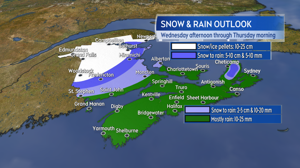
An autumn mix of snow, ice pellets, and rain will impact the Maritimes Wednesday afternoon into early Thursday morning.
The storm will move up the Bay of Fundy and into the Gulf of St. Lawrence, bringing rain and winds to the south and east of its track, and cold and snow to the north and west.
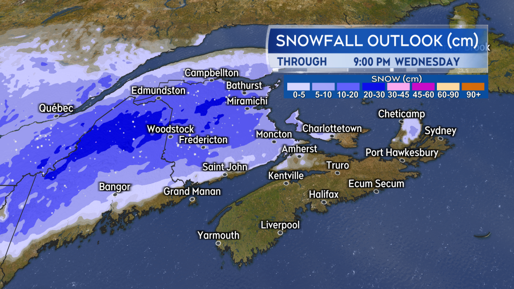
Parts of northern and central New Brunswick are expected to see the most snow.
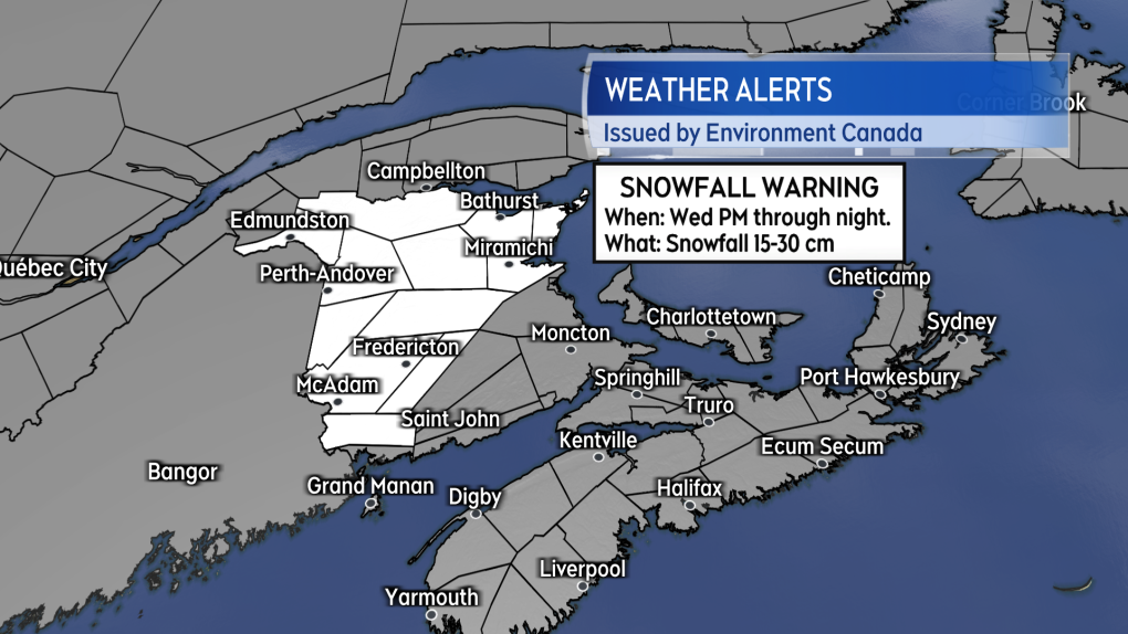 Snowfall warnings are in effect for parts of New Brunswick and Quebec. Northern Maine is under winter Storm warnings and advisories.
Environment Canada expanded snowfall warnings into northern and northeastern areas of New Brunswick Tuesday afternoon. Between 15 and 30 cm of snow is expected, which could make for difficult driving conditions during the commute late Wednesday afternoon.
Snowfall warnings also extend back into the St. Lawrence River Valley of Quebec and northern Maine is under a winter storm warning by the National Weather Service.
 Commuters in much of New Brunswick should plan for winter road conditions Wednesday afternoon and night.
The highest totals of snow and ice pellets are expected in the area from Woodstock to Edmundston and then east to Bathurst in New Brunswick.
The eastern coastline of New Brunswick will see a mix of rain and ice pellets. The turn to rain will limit snow accumulation in southern New Brunswick. While Fredericton could pick up 5 to 10 cm of snow, Saint John and Moncton will likely see 5 cm or less before it changes to rain.
On Prince Edward Island, there may be some initial snow of 2 to 5 cm up west before it turns to rain.
In Nova Scotia, it will mostly be a rain event, with the exception of some snow in the Cape Breton Highlands.
 The snowiest weather will be in central and northern areas of New Brunswick. Other areas in the Maritimes will see a quicker turn to rain.
The mix of snow and rain will clear to the east early Thursday morning. Areas of showers and flurries will linger in the wake of the system throughout the day Thursday.
Gusty east and southeast winds will accompany the precipitation. The highest gusts will most likely be felt on the Bay of Fundy coastline of New Brunswick and the Atlantic coastline of Nova Scotia, where they will peak between 50 km/h and 70 km/h. A wind warning has been issued for northern Inverness County in Cape Breton, with gusts expected to reach 100 km/h.
Wind in northern New Brunswick will be out of the northeast and gust 20 km/h to 50 km/h. While the wind in northern New Brunswick won’t be particularly strong, it will blow the falling snow around, reducing visibility.
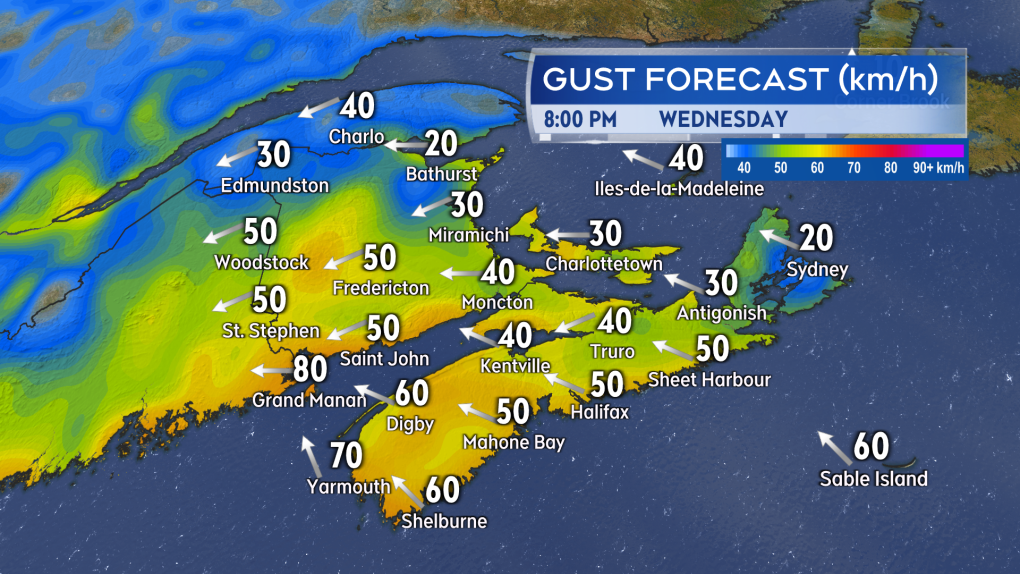 A gusty southeasterly wind will be present for coastal areas Wednesday evening. A colder northeast wind will be felt in northern New Brunswick.
Updates on the amounts and timing of the snow will be shared on CTV News at Noon, 5, 6, and 11:30 p.m. and online.


CTVNews.ca Top Stories
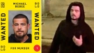
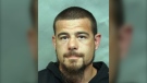
Canada's most wanted fugitive arrested in P.E.I. in connection with Toronto homicide
A suspect in a fatal shooting in Toronto’s east end last summer has been arrested in Charlottetown, just one week after he topped a list of Canada’s most wanted fugitives.
Concerns about plexiglass prompt inspections at some Loblaws locations in Ottawa
Inspections are underway at more than one Loblaws location in Ottawa after complaints were filed about tall plexiglass barriers.
Wisconsin school district says active shooter 'neutralized' outside middle school
A Wisconsin school district said an active shooter was 'neutralized' outside a middle school in Mount Horeb on Wednesday, and no one inside the building was injured.
Poilievre unrepentant over calling Trudeau 'wacko' as his MPs say Speaker should resign
An unrepentant Pierre Poilievre returned to the House of Commons on Wednesday to pepper the prime minister about his drug decriminalization policies after being booted the day prior for refusing to take back calling Justin Trudeau 'wacko' over his approach to the issue.
NDP Leader Jagmeet Singh confirms his party will support the Liberals' federal budget
NDP Leader Jagmeet Singh says his party will support the federal budget, ending any speculation that the party could pull out of its deal with the minority Liberal government.
Toddler of Phoenix first responder dies after bounce house goes airborne
A two-year-old child died after a strong gust of wind sent the bounce house he was in airborne and into a neighbouring lot in central Arizona, the Pinal County Sheriff's Office said.
Dental care program accepting claims for 1 million seniors
Citizens' Services Minister Terry Beech says 1,200 seniors have already visited a dentist and had their claims processed by the federal government's new dental care plan.
Lawyers for alleged serial killer to argue he is not criminally responsible
Defence lawyers told court they will argue alleged serial killer Jeremy Skibicki is not criminally responsible for the deaths of four Indigenous women by way of a mental disorder.
B.C. tribunal decides first case involving non-consensual sharing of intimate images
In a first-of-its-kind case, a B.C. tribunal has ruled on a dispute involving the non-consensual sharing of intimate images, awarding damages and issuing orders that the photos be destroyed and taken offline.
Shopping Trends
The Shopping Trends team is independent of the journalists at CTV News. We may earn a commission when you use our links to shop. Read about us.


Toronto
-
Canada's most wanted fugitive arrested in P.E.I. in connection with Toronto homicide
A suspect in a fatal shooting in Toronto’s east end last summer has been arrested in Charlottetown, just one week after he topped a list of Canada’s most wanted fugitives.
-
Ontario's police watchdog continues probe of high-speed pursuit involving fatal crash
The investigation continues into a collision that killed two grandparents and their infant grandchild during a high-speed police chase on the wrong way of Highway 401 east of Toronto.
-
Ontario woman surprised after 20-year-old fines suddenly tank credit score
An Ontario woman says that she was shocked when fines from 20 years ago suddenly tanked her credit score last week, but the situation may not be as unusual as it seems, according to at least one debt expert.
Calgary
-
Appeal denied for man convicted in 2019 murder in Airdrie, Alta.
The Alberta Court of Appeal has denied the request of an Airdrie man to set aside his murder conviction in the fatal shooting of his neighbour in 2019.
-
Demand for lower-priced listings driving up Calgary home prices, sales
Calgary real estate prices continued to rise in April, as demand for more affordable, higher-density properties remained high.
-
Province backtracks, will continue to fund low-income transit pass program in Calgary, Edmonton
A day after Calgary's mayor called the Alberta government's decision to pull its funding for the low-income transit pass program "cruel," the province is reversing its decision.
Edmonton
-

Day parole granted for man convicted of manslaughter in deaths of Métis hunters
A man convicted of manslaughter in the 2020 deaths of two Métis hunters has been granted day parole.
-
'It's very special to me': Oilers superfan shows off collection of a lifetime
Edmonton Oilers superfan Tina Duncan is an avid collector of the team's memorabilia who has transformed her basement into a fan's paradise.
-
Edmonton fire chief stepping down
Edmonton Fire Rescue Services (EFRS) announced Wednesday morning Joe Zatylny will step down as its chief on May 10.
Montreal
-
McGill offers 'forum' with protesters after judge dismisses injunction request
A judge has rejected a request from two McGill University students for a court injunction to limit where protesters can go on campus.
-
Quebec schools must have designated boys and girls bathrooms: education minister
Even though the Quebec advisory committee on gender identity has yet to make its recommendations, Education Minister Bernard Drainville has decided to ban gender-neutral toilets and changing rooms in public schools.
-
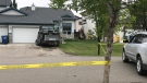
Woman killed before Montreal fire, police arrest suspect
A 29-year-old woman has been arrested in the death of a 42-year-old woman in Montreal's Pointe-aux-Trembles district.
Ottawa
-
 BREAKING
BREAKING Federal employees will be required to spend 3 days a week in the office
Starting in September, public servants in the core public administration will be required to work in the office a minimum of three days a week. The Treasury Board Secretariat says executives will need to be in the office four days per week.
-
Concerns about plexiglass prompt inspections at some Loblaws locations in Ottawa
Inspections are underway at more than one Loblaws location in Ottawa after complaints were filed about tall plexiglass barriers.
-
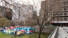
Students launch pro-Palestinian encampment at uOttawa
A group of students have launched an encampment at the University of Ottawa (uOttawa) calling on the institution to cut financial ties with Israel, despite the school warning that such action would not be tolerated.
London
-

Protestors set up tent encampment on campus, Western University says
As protestors set up tent encampments at universities across Canada and the U.S., London, Ont.’s Western University finds itself no exception on Wednesday.
-
'Breaks my heart': Residents react to removal of Canada goose nest, destruction of eggs
Residents who live in the Hyde Park Place apartments in north London, Ont. said they are heartbroken after Old Oak Properties removed two geese nests, containing more than half a dozen eggs.
-
'They were fortunate': No injuries reported in London rollover crash
The collision at the intersection of Gainsborough and Aldersbrook Roads, was forceful enough to flip a grey SUV. A black SUV was also damaged.
Barrie
-
Police crack down on auto theft with formation of a new unit in Simcoe County
Barrie Police and South Simcoe Police are joining forces to take on the epidemic of auto thefts.
-
The Barrie Airshow set to take flight over Kempenfelt Bay
The Barrie Airshow is set to take flight above Kempenfelt Bay this summer.
-
Wasaga Beach gets provincial approval for its first high school
Wasaga Beach will finally have its first high school. On Wednesday, the Town announced the state-of-the-art kindergarten to Grade 12 school project will go ahead.
Northern Ontario
-

Man from Tweed, Ont. selling home due to wife's passing set to face higher capital gains tax
Terry Sutherland is trying to sell his home in Tweed, Ont., but he'll likely be hit by the capital gains tax rise.
-
Baby, grandparents among 4 people killed in wrong-way police chase on Ontario's Hwy. 401
A police chase which started with a liquor store robbery in Bowmanville Monday night ended in tragedy some 20 minutes later when a suspect fleeing police entered Highway 401 in the wrong direction and caused a pileup which killed an infant and the child's grandparents, as well as the suspect, investigators say.
-
Ontario woman surprised after 20-year-old fines suddenly tank credit score
An Ontario woman says that she was shocked when fines from 20 years ago suddenly tanked her credit score last week, but the situation may not be as unusual as it seems, according to at least one debt expert.
Kitchener
-
 BREAKING
BREAKING Ont. woman who faked pregnant to defraud doulas arrested again on similar charges
A Brantford, Ont. woman who was sentenced to house arrest earlier this year for defrauding and deceiving doulas has been arrested again on similar charges.
-
1,428 Waterloo Region high school students suspended over out-of-date vaccination records
Nearly 1,500 Waterloo Region high school students have been suspended over out-of-date vaccination records.
-
More than eight million contraband cigarettes seized by OPP
OPP say two traffic stops in Brant and Haldimand counties resulted in the seizure of 8,422,800 unstamped contraband cigarettes.
Windsor
-

'Shocking breach of trust': Former Windsor denturist sent to jail for sexual assault
A former Windsor denturist is being sent to jail for sexual assault.
-
Gunshots investigated in east Windsor
Windsor police are investigating after multiple shots were fired in east Windsor.
-
'I was shaking': retired auto worker wins $100,000 with scratch ticket
After 40 years of playing the lottery, a retired Windsor auto worker has won $100,000.
Winnipeg
-
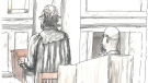
Lawyers for alleged serial killer to argue he is not criminally responsible
Defence lawyers told court they will argue alleged serial killer Jeremy Skibicki is not criminally responsible for the deaths of four Indigenous women by way of a mental disorder.
-
NEW
NEW Interprovincial drug bust led by Winnipeg police turns up millions in drugs, cash, luxury goods
More than a dozen people are facing charges, the majority Winnipeggers, after an interprovincial drug bust that turned up millions of dollars in cash, drugs, guns, jewelry and luxury vehicles.
-
Manitoba providing money for memorial to honour Carman homicide victims
The provincial government is providing funding to the Town of Carman to honour the five people who were killed in February, and to help those who helped the town heal.
Regina
-

Here's how one of Sask.'s largest power plants was knocked out for 73 days, and what it took to fix it
A group of SaskPower workers recently received special recognition at the legislature – for their efforts in repairing one of Saskatchewan's largest power plants after it was knocked offline for months following a serious flood last summer.
-
These driving offences now come with an automatic impoundment, licence suspension in Sask.
Drivers in Saskatchewan will now lose their licence for a week and their vehicle for a month if they are caught committing certain high-speed and dangerous offences on the road.
-
'Not an easy task': Police begin 'meticulous' search at Saskatoon landfill in Mackenzie Trottier case
Police officers and cadaver dogs have begun searching the Saskatoon landfill for answers in the Mackenzie Lee Trottier case.
Saskatoon
-

'Not an easy task': Police begin 'meticulous' search at Saskatoon landfill in Mackenzie Trottier case
Police officers and cadaver dogs have begun searching the Saskatoon landfill for answers in the Mackenzie Lee Trottier case.
-
High school students gear up for Robot Rumble at Sask. Polytech
High school students from across the province are gearing up for a battle of technical skills in the annual Robot Rumble at Sask. Polytechnic on Thursday.
-
'Brutal, cruel, and frankly inhumane': Sask. RCMP describe the sprawling investigation of Tiki Laverdiere's murder
The last of 10 people convicted in the brutal killing of a 25-year-old Edmonton woman was sentenced on Friday, closing a chapter on one of the largest homicide investigations for the Saskatchewan RCMP Major Crimes Investigations unit.
Vancouver
-

B.C. tribunal decides first case involving non-consensual sharing of intimate images
In a first-of-its-kind case, a B.C. tribunal has ruled on a dispute involving the non-consensual sharing of intimate images, awarding damages and issuing orders that the photos be destroyed and taken offline.
-
8-year sentence after guilty plea in 2022 Surrey shooting case
A drug dealer who shot his customer in the chest over an unpaid debt in 2022 has been sentenced to eight years in prison for manslaughter.
-
Reluctant to reconnect with an old friend? This B.C. study might help you understand why
Have you ever wanted to rekindle an old friendship, but stopped short of actually reaching out?
Vancouver Island
-
Victoria police say speed a factor in crash that seriously injured driver
Investigators say speed was likely a contributing factor in a single-vehicle crash that sent a driver to hospital with serious but non-life-threatening injuries in Victoria.
-
Gaza protesters at University of Victoria say encampment will stay until demands are met
A pro-Palestinian protest camp has formed at the University of Victoria in solidarity with the people of Gaza and with similar encampments that have sprung up on university and college campuses in opposition to the Israel-Hamas war.
-
B.C. tribunal decides first case involving non-consensual sharing of intimate images
In a first-of-its-kind case, a B.C. tribunal has ruled on a dispute involving the non-consensual sharing of intimate images, awarding damages and issuing orders that the photos be destroyed and taken offline.
Kelowna
-

B.C. breweries take home awards at World Beer Cup
Out of more than 9,000 entries from over 2,000 breweries in 50 countries, a handful of B.C. brews landed on the podium at the World Beer Cup this week.
-
B.C. man rescues starving dachshund trapped in carrier: BC SPCA
An emaciated dachshund is now recovering thanks to a Good Samaritan who found the pup near a biking trail in Kelowna, according to the BC SPCA.
-
Search crews called in after missing Kelowna senior's truck found
Search and rescue crews have been called in after a vehicle belonging to a missing senior was located near a rural intersection outside of Kelowna Tuesday.


