Special weather statements issued ahead of freezing rain risk for the Maritimes Friday
The Maritime region is set to experience a weather whiplash when unseasonably warm temperatures drop to below zero at the end of the week.
A south and southwest wind will continue to move milder air up the eastern seaboard into the Maritimes Wednesday night into Thursday.
Temperatures will rise through the night with highs on Thursday expected to range from six to 12 degrees across the Maritimes. In some cases, those temperatures will be warm enough to challenge standing high-temperature records for a Feb. 16.
As an example, the standing high-temperature record for the Halifax area is 10.8 C set in 2016, with the forecast high near 11 C for Thursday. Temperatures for most of the Maritimes will fall back to or below freezing Thursday night, which will contribute to a messy Friday forecast.
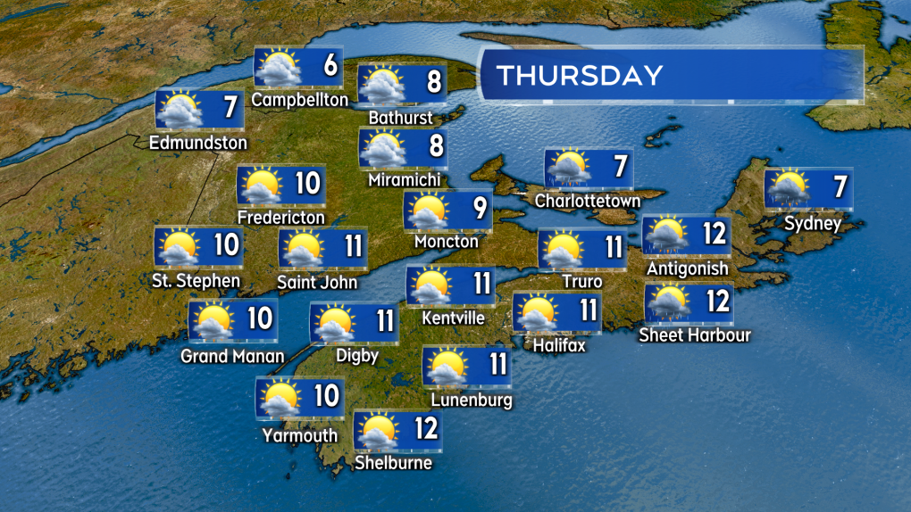 Unseasonably warm temperatures are expected Thursday, potentially breaking some record highs for Feb.16.
On Friday, a low-pressure system is expected to come out of the northeastern United States and cross the Maritimes. There is a risk of an extended period of freezing rain and ice pellets for southern New Brunswick, Nova Scotia, and Prince Edward Island. The risk of freezing rain is highest in southern New Brunswick and Prince Edward Island during the day on Friday.
Friday evening and night should see both those areas turn to snow as the temperature falls. For Nova Scotia, the risk of freezing rain/ice pellets may be highest Friday evening and night as temperatures during the day will initially be above freezing.
Environment Canada has special weather statements out for these areas cautioning that freezing rain could extend up to 4 hours in duration.
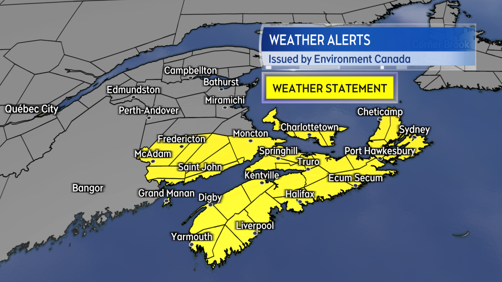 Special weather statements are in effect cautioning the risk of freezing rain Friday.
Central and northern areas of New Brunswick will have colder temperatures so the precipitation there is more likely to be a mix of snow and ice pellets. There is the potential for the snow and ice pellets to accumulate into a range of 10 to 20 cm.
The area of the province that looks most likely to see those amounts runs from Woodstock to Grand Falls and the east toward Miramichi. It is also possible that parts of western Prince Edward Island could end up on the snowier side of the system. Snow totals are likely to range from five to 10 cm for some of the northernmost communities of New Brunswick including Edmundston and Campbellton-Dalhousie.
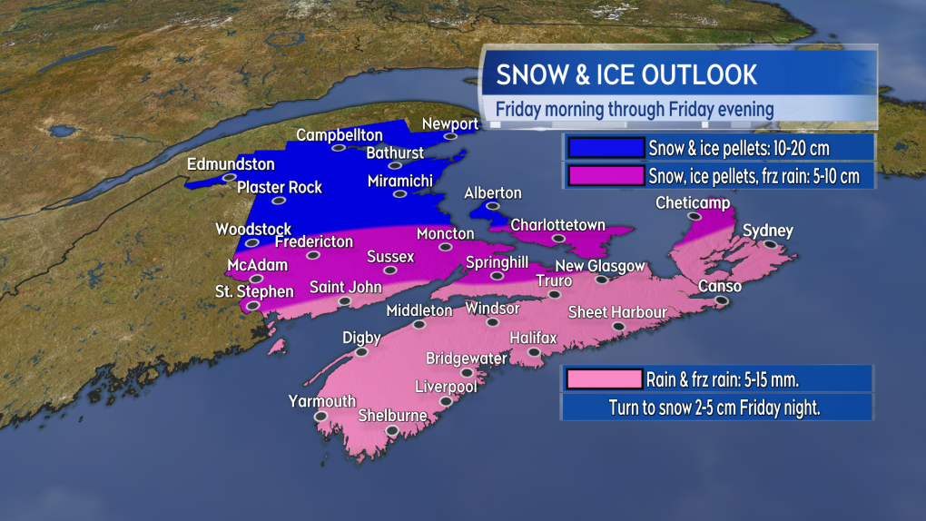 A snowy, icy mix of weather is expected for much of the Maritimes Friday. Rain may initially fall during the day in Nova Scotia before turning to freezing rain, ice pellets, and snow Friday evening and night.
A shift north or south with the expected track of the system would have an impact on the amount and type of precipitation expected. For example, if the low does come in further to the north higher snowfall amounts would occur in northern areas of New Brunswick with rain, rather than freezing rain, more likely in southern New Brunswick, Nova Scotia, and Prince Edward Island.


CTVNews.ca Top Stories

Trump picks Brooke Rollins to be agriculture secretary
U.S. President-elect Donald Trump has chosen Brooke Rollins, president of the America First Policy Institute, to be agriculture secretary.
Walking pneumonia is surging in Canada. Is this unusual?
CTVNews.ca spoke with various medical experts to find out the latest situation with the typically mild walking pneumonia in their area and whether parents should be worried.
Lotto Max jackpot climbs to $80M, tying record for largest prize
The Lotto Max jackpot has climbed to $80 million for just the second time in Canadian lottery history.
Retiring? Here's how to switch from saving for your golden years to spending
The last paycheque from a decades-long career arrives next Friday and the nest egg you built during those working years will now turn into a main source of income. It can be a jarring switch from saving for retirement to spending in retirement.
Joly, Blair condemn anti-NATO protest in Montreal that saw fires, smashed windows
Federal cabinet ministers condemned an anti-NATO protest in Montreal that turned violent on Friday, saying 'hatred and antisemitism' were on display, but protesters deny the claim, saying they demonstrated against the 'complicity' of NATO member countries in a war that has killed thousands of Palestinians.
Police thought this gnome looked out of place. Then they tested it for drugs
During a recent narcotics investigation, Dutch police said they found a garden gnome made of approximately two kilograms of MDMA.
'Her shoe got sucked into the escalator': Toronto family warns of potential risk of wearing Crocs
A Toronto family is speaking out after their 10-year-old daughter's Crocs got stuck in an escalator, ripping the entire toe area of the clog off.
Canada's top general takes on U.S. senator in defending womens' role in combat units
Canada's top general firmly rejected the notion of dropping women from combat roles -- a position promoted by president-elect Donald Trump's nominee for defence secretary -- at a security forum underway in Halifax on Saturday.
Ottawa driver fined for hauling thousands of empty cans in trunk of car
Ontario Provincial Police stopped an Ottawa man for dangerously hauling thousands of empty cans from the back of his car.
Shopping Trends
The Shopping Trends team is independent of the journalists at CTV News. We may earn a commission when you use our links to shop. Read about us.


Toronto
-

'Her shoe got sucked into the escalator': Toronto family warns of potential risk of wearing Crocs
A Toronto family is speaking out after their 10-year-old daughter's Crocs got stuck in an escalator, ripping the entire toe area of the clog off.
-
'Still working full time on it:' One year later police continue to search for gunman in Caledon double murder linked to ex-Olympian
One year after a couple was shot and killed in their Caledon home in what investigators have described as a case of mistaken identity, Ontario Provincial Police say they are still trying to figure out who pulled the trigger.
-
Maple Leafs' Matthews says Wednesday return possible after visiting doctor in Germany
Auston Matthews is back in Toronto and says a return to action Wednesday is possible after the injured Maple Leafs captain visited a doctor in Germany.
Calgary
-

Snowfall warning for Calgary and southern Alberta expected to continue throughout Saturday
A snowfall warning for Calgary remained in effect early Saturday morning and looks poised to be hanging around all weekend.
-
Need something fixed? Repair Exchange Calgary has a volunteer for that
Repair Exchange Calgary is bringing a few good fixers to the Hillhurst Flea Market on Sunday.
-
Spruce Meadows Christmas Market adds Allen the Alpaca to Sunday lineup
The Spruce Meadows Christmas Market is bringing in a special guest Sunday.
Edmonton
-

From Instagram to IRL: Where to find this year's trendy treats in Edmonton
From globally-inspired pastries to vegan fast food and Connor McDavid-themed culinary delights, Edmonton has a lot to offer anyone looking to try something trendy.
-
Edmonton calls parking ban after city hit with heavy snowfall
Edmonton has called its first parking ban of the season as the city remained under a snowfall warning.
-
Hit-and-run driver wanted after pedestrian hit in southeast Edmonton
Police are looking for a hit-and-run driver after a pedestrian was hit on Thursday night.
Montreal
-

Montreal prepares to sell long-abandoned Empress theatre
The Empress Theatre, a nearly century-old landmark in Montreal's Notre-Dame-de-Grâce (NDG) neighbourhood, may soon be revitalized.
-
Quebec MNAs continue screen time consultations with students
Quebec's special commission on the impact of screen time and social media addiction among youth made a stop at Westmount High School this week, speaking directly with students about their habits and concerns.
-
Ottawa to deliver apology, $45M in compensation for Nunavik Inuit dog slaughter
The federal government is providing $45 million in compensation to Inuit in Nunavik as part of Canada's apology for its role in the killing of sled dogs between the mid-1950s and the late 1960s.
Ottawa
-

Mixed reaction from Ottawa business owners, customers on GST exemption
Business owners say they've been left with questions about how a temporary tax exemption to the GST will work after the federal government announcement the policy last week.
-
Ottawa councillor violated Code of Conduct for daycare incident last summer, integrity commissioner concludes
The City of Ottawa's integrity commissioner has found West-Carleton March Coun. Clarke Kelly has violated the Code of Conduct for city officials and should be reprimanded following an altercation with a local daycare owner and staff last summer.
-
Ottawa driver fined for hauling thousands of empty cans in trunk of car
Ontario Provincial Police stopped an Ottawa man for dangerously hauling thousands of empty cans from the back of his car.
London
-

Two people airlifted, several taken to hospital due to collision
Two people have been airlifted to hospital following a serious collision in Norfolk County.
-
South Bruce residents vote in favour of hosting nuclear waste project in narrow referendum
South Bruce residents narrowly voted in favour of plans to bury Canada’s most radioactive nuclear waste under their municipality on Monday.
-
St. Thomas, Ont. and San Jose, Calif. celebrate hockey legend on night his jersey is retired
The Jumbo elephant monument in St. Thomas, Ont. will be lit in teal Saturday night as the city honours hockey legend Joe Thornton.
Barrie
-

New Orillia Christmas tree shines bright
After Orillia’s underwhelming Christmas tree-lighting ceremony last year became a viral sensation, the City lit a new, bigger, brighter and healthier tree Friday evening.
-
Missing man in Collingwood
Collingwood OPP are searching for a 79-year-old man who was last seen early Saturday morning.
-
Highway 400 reopens in Muskoka Lakes after fatal propane truck rollover
Highway 400 reopened late Friday night in Georgian Bay Township after emergency crews tended to a fatal tanker truck rollover Friday morning.
Northern Ontario
-

Northern Ont. First Nation files claim against Ontario and Newmont mining
Taykwa Tagamou Nation, a Cree First Nation located within Treaty 9, has filed a statement of claim against the Province of Ontario and Newmont, a mining company that owns properties in Timmins.
-
Senior killed in dog attack in northern Ont.
An 81-year-old was killed in a dog attack this week in Bonfield, Ont. Police believe three dogs were involved.
-
Whole Foods carrots pulled in expanded recall for E. coli: CFIA
The Canadian Food Inspection Agency has announced an expanded recall on carrots over risks of E. coli O121 contamination, according to a notice issued Friday.
Kitchener
-

Advocates push for anti-renoviction bylaws as Waterloo Region reports affordable housing progress
On National Housing Day, housing advocacy group ACORN continued to push for anti-renoviction bylaws.
-
Man charged in Kitchener crash involving Grand River Transit LRT
Charges were laid after a crash between an LRT train and a Dodge vehicle shut down a busy Kitchener street for more than eight hours on Thursday.
-
How University of Waterloo researchers could help charge your devices by moving your body
Imagine being able to charge your devices through your body’s movements.
Windsor
-

Charity produces record amounts of non-perishable food amidst rise in food insecurity
A Windsor-Essex charitable organization created a record amount of non-perishable food amidst an increase in food insecurity, both at home and abroad.
-
No impaired drivers detected during Friday night RIDE checks
The Windsor Police Service reports no detected impaired drivers on Friday night during their RIDE checks.
-
Truck fire on the Ambassador Bridge
Windsor fire responded to a transport truck fire on Friday afternoon on the Ambassador Bridge.
Winnipeg
-

Missing Neepawa senior found dead: RCMP
An 81-year-old man who went missing Friday has been found dead, Spruce Plains RCMP said.
-
Snowfall warning in effect for southwestern Manitoba
Some areas could expect snowfall totals of 15 to 25 centimetres.
-
The Thriftmas Special: The benefits of second-hand holiday shopping
The holidays may be a time for family, joy and togetherness, but they can also be hard on the wallet.
Regina
-

City of Regina releases snowfall response plan ahead of next blast of wintery weather
Many parts of Saskatchewan will be hit with another round of wintery weather on Saturday, and Regina is no exception, with up to 25 centimetres of snow expected to accumulate.
-
NDP calls for investigation into food prices in northern Sask. after scurvy cases discovered
The Saskatchewan NDP is calling for an investigation into food prices in the northern part of the province after 27 cases of scurvy were discovered.
-
Ministry of Highways releases annual snow campaign as Sask. braces for more snow
Snowplows will be on standby ready to go as the province is expected to get more snow over the weekend.
Saskatoon
-

'I'm excited to take it on': Saskatoon businesses weigh in on GST exemption
Some local businesses say the federal government’s recent plan to pull back GST on several items is a positive initiative, but it should have been rolled out earlier in the holiday season.
-
Watermain break closes Saskatoon road
The City of Saskatoon is advising motorists of road closures due to a watermain break that caused flooding on Millar Avenue near Circle Drive.
-
Why isn't Saskatoon's new downtown shelter open yet?
Saskatoon's new downtown shelter must undergo renovations before it can open, according to the operator of the site.
Vancouver
-

Black bear killed in self defence after attack on dog-walker in Maple Ridge
A black bear has died following a brawl with a man on a trail in Maple Ridge.
-
Man arrested after allegedly attempting to set fire to Vancouver City Hall
A 36-year-old man was arrested and is facing criminal charges after allegedly trying to start a blaze at the front of Vancouver City Hall Friday night.
-
Woman killed in Vancouver's Joyce-Collingwood neighbourhood, suspect in custody
A woman is dead and a 46-year-old suspect is in custody after an incident in Vancouver's Joyce-Collingwood neighbourhood overnight.
Vancouver Island
-

BC Hydro says power almost fully restored after B.C. windstorms
British Columbia's electric utility says it has restored power to almost all customers who suffered outages during the bomb cyclone earlier this week, but strong wind from a new storm has made repairs difficult in some areas.
-
Fall legislative sitting scrapped in B.C. as Speaker Chouhan confirmed to serve again
There won't be a sitting of the British Columbia legislature this fall as originally planned.
-
Canada Post down eight million parcels amid strike as talk carry on over weekend
Canada Post says it has seen a shortage of more than eight million parcels amid an ongoing strike that has effectively shut down the postal system for nine days compared with the same period in 2023.
Kelowna
-

Man in hospital following targeted shooting in Kamloops
Police are appealing for information on a targeted shooting that resulted in the hospitalization of a man in Kamloops.
-
Police cleared of fault in fatal 2023 crash in B.C.'s Interior
British Columbia's independent police watchdog has cleared officers of wrongdoing in a crash where three people were killed south of Kamloops in July of last year.
-
B.C. woman sentenced for stealing $14K in funds raised for schoolkids
A B.C. woman who stole more than $14,000 in volunteer-raised funds that were supposed to be spent on school supplies and programs – including hot meals for vulnerable kids – won't spend any time in jail.


