The next round of snow and rain arrives Sunday for the Maritimes
 Snow blankets downtown Halifax on Jan. 29, 2024. (Paul Hollingsworth/CTV Atlantic)
Storm reports
A mix of heavy snow, freezing rain, and heavy rain came across the Maritimes Thursday. The most snow accumulated for parts of central and eastern New Brunswick as well as western Prince Edward Island with amounts of 10 to 30 cm. Several hours of a mix of freezing rain and ice pellets occurred in southeastern New Brunswick and central and eastern Prince Edward Island. Nova Scotia picked up 40 to 80 mm of rain and finished with a lighter mix of snow, ice pellets, and freezing rain Thursday night and early Friday morning.
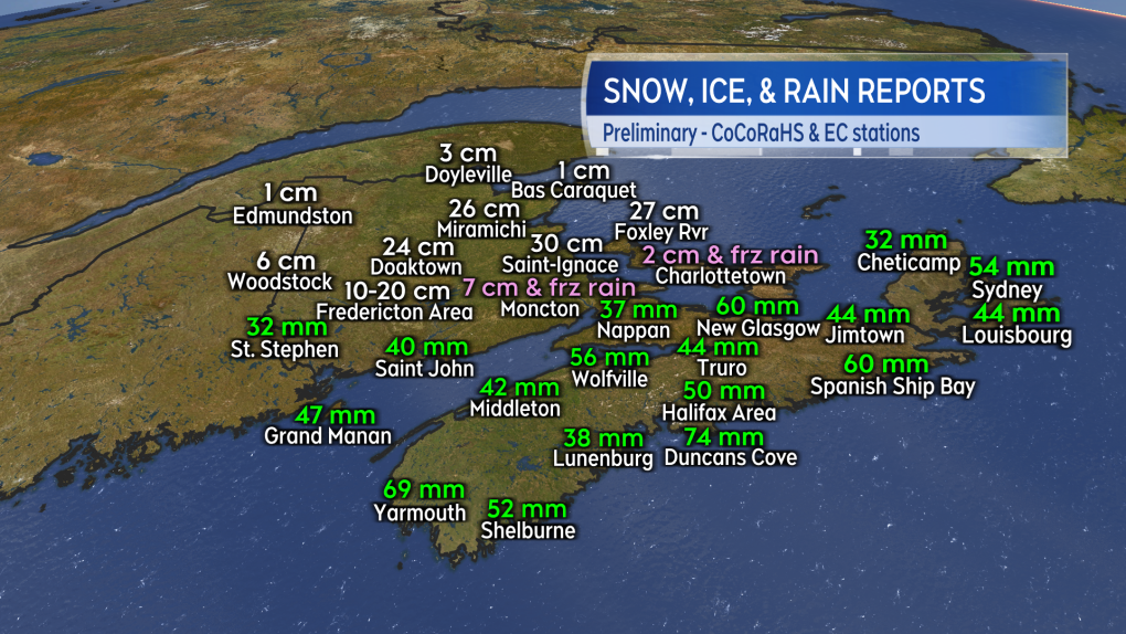 Reported snow and rain amounts in the Maritimes from the Community Collaborative Rain, Hail and Snow Network (CoCoRaHS) volunteers and Environment Canada monitored weather stations.
The same storm system has gone on to have more extreme impacts on Newfoundland. A winter storm warning in effect for St. John’s calls for snow that could total 55 to 85 cm by Saturday morning.
Snow and rain returns Sunday
A low pressure system moving out of the northeastern United States returns a mix of snow and rain to the Maritimes on Sunday.
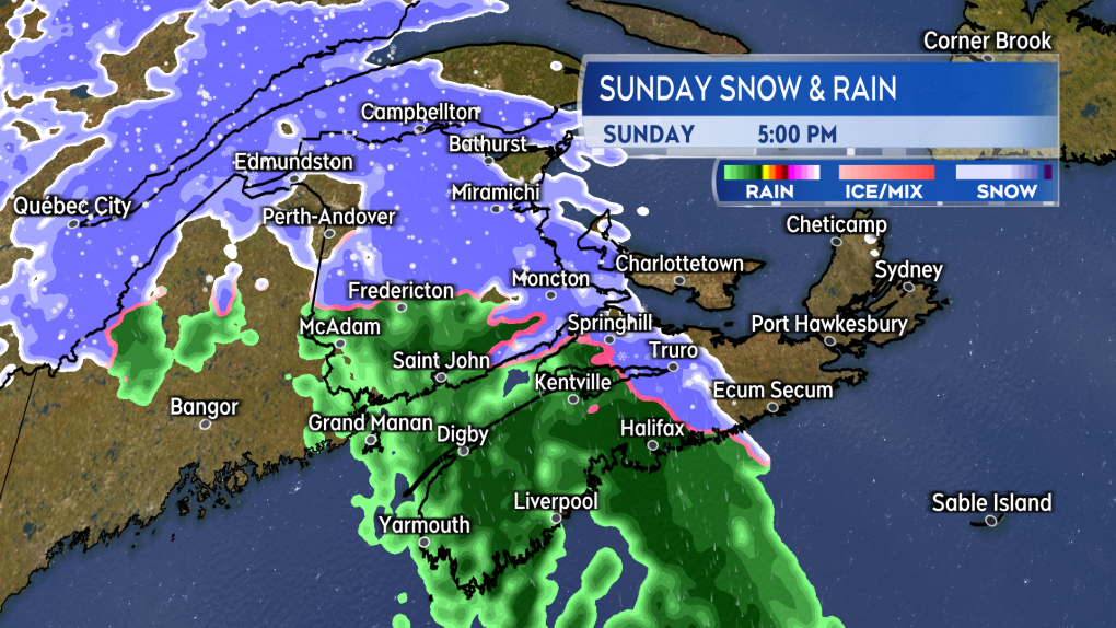 A mix of snow and rain develops across the Maritimes through Sunday.
The mix of precipitation is expected to develop west-to-east across the Maritimes Sunday afternoon through Sunday evening. Most of the Maritimes will see rain or a quick turn from snow to rain. A more significant period of snow is possible for northern areas of New Brunswick.
For the northernmost areas of New Brunswick there is the potential for 5 to 15 cm of snow. Some of the higher elevations could pick up amounts of 15 to 30 cm. That would include the hills and mountains that start just to the north of Fredericton and continue up through the Mount Carleton area. Due to the system arriving late Sunday night for Cape Breton, parts of the island could possibly pick up 5 to 10 cm of wet snow, including around the Sydney area.
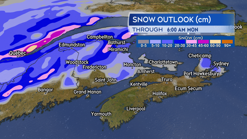 The most snow potential for northern areas of New Brunswick, especially in higher terrain.
Rain from the system is expected to be in a general range of 10 to 30 mm. Higher local amounts may be possible in the southwest of New Brunswick and the southwest of Nova Scotia. A mix of snow and rain may continue into Monday morning for Cape Breton and the remainder of the Maritimes with some scattered showers and flurries on Monday.
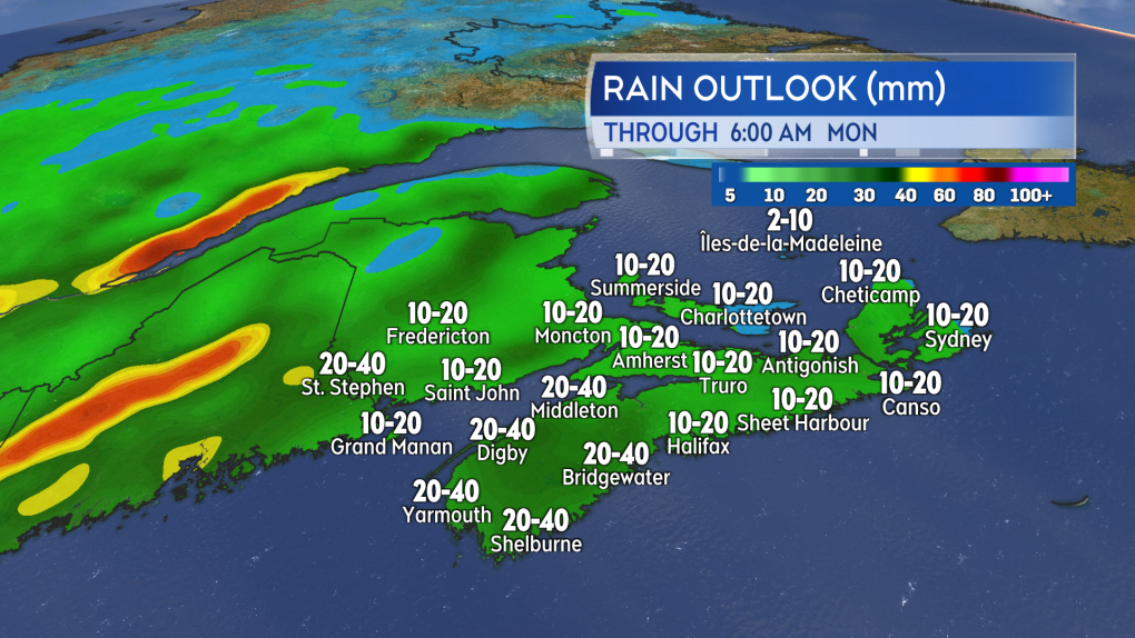 The rain is expected to generally total 10 to 30 mm, and higher local amounts may be possible in a few areas.


CTVNews.ca Top Stories

Police arrest 3 Indian nationals in killing of B.C. Sikh activist Hardeep Singh Nijjar
Three people have been arrested and charged in the killing of B.C. Sikh activist Hardeep Singh Nijjar – as authorities continue investigating potential connections to the Indian government.
Grandparents killed in wrong-way crash on Hwy. 401 identified
A 60-year-old man and a 55-year-old woman killed in a wrong-way crash on Highway 401 earlier this week have been identified by the Consulate General of India in Toronto.
Quebec man who threatened Trudeau, Legault online sentenced to 20 months in jail
A Quebec man who pleaded guilty to threatening Prime Minister Justin Trudeau and Premier François Legault has been sentenced to 20 months in jail.
TD worst-case scenario more likely after drug money laundering allegations: analyst
TD Bank Group could be hit with more severe penalties than previously expected, says a banking analyst after a report that the investigation it faces in the U.S. is tied to laundering illicit fentanyl profits.
Canadian doctor concerned new weight-loss drug Wegovy may be used inappropriately
As Wegovy becomes available to Canadians starting Monday, a medical expert is cautioning patients wanting to use the drug to lose weight that no medication is a ''magic bullet,' and the new medication is meant particularly for people who meet certain criteria related to obesity and weight.
Biscuits with possible plastic pieces, metal found in ground pork: Here are the recalls for this week
Here are the latest recalls Canadians should watch out for, according to Health Canada and the Canadian Food Inspection Agency.
Britney Spears 'home and safe' after paramedics responded to an incident at the Chateau Marmont, source tells CNN
A source close to singer Britney Spears tells CNN that the pop star is 'home and safe' after she had a 'major fight' with her boyfriend on Wednesday night at the Chateau Marmont in West Hollywood.
Local MP, MLA call on federal government to remove sunken vessel in Saint John River
An MP and an MLA are calling for the removal of a sunken vessel in the Saint John River.
Human remains found in rural Sask. possibly a decade old, RCMP say
RCMP say human remains found in a rural area in central Saskatchewan may have been there for a decade or more.
Shopping Trends
The Shopping Trends team is independent of the journalists at CTV News. We may earn a commission when you use our links to shop. Read about us.


Toronto
-

Police officer hit by driver of fleeing vehicle in Toronto
York Regional Police say they are continuing to search for a suspect in an auto theft investigation who was captured on video running over a police officer in Toronto last month.
-
Grandparents killed in wrong-way crash on Hwy. 401 identified
A 60-year-old man and a 55-year-old woman killed in a wrong-way crash on Highway 401 earlier this week have been identified by the Consulate General of India in Toronto.
-
Video shows suspect setting Toronto-area barbershop on fire
Video of a suspect lighting a Richmond Hill barbershop on fire earlier this week has been released by police.
Calgary
-

Alberta impaired driving victims applaud Mandatory Alcohol Screening in Ontario
Mandatory Alcohol Screening has been in place in Alberta for the past few years and a move by the Ontario Provincial Police to begin enforcing breath samples at all traffic stops is being applauded by local victims of impaired driving.
-
Globe Cinema sale could signal a cultural shift in Calgary’s developing film industry
Many in Calgary’s film industry are worried about the potential sale of another iconic downtown theatre, and what it could mean for the local arts scene.
-
2 defensive backs released, 2 former Stampeders elected to CFL Hall of Fame
The Calgary Stampeders made a couple of surprise moves Friday, releasing a pair of defensive backs.
Edmonton
-
Man arrested after body found 3 months after apartment fire
A man accused of arson in a January Old Strathcona apartment fire is expected to be charged with manslaughter after a body was discovered in the burned building late last month.
-
Alberta doctors' advocate decries federal capital-gains tax changes
Federal tax changes could soon make it difficult for people to find a family doctor, says the Alberta Medical Association.
-
Video of Michelle Hadwen before her death in 2009 released by Edmonton police
More than 15 years after the death of Michelle Hadwen, police are still searching for the person responsible for her death.
Montreal
-

Premier Legault reiterates that McGill pro-Palestinian camp must be dismantled
Quebec Premier François Legault reiterated that the pro-Palestinian encampment at McGill University must be dismantled while police remain 'on the lookout for new developments.'
-
Judge worries amendment to Quebec language law will cause 'undue delays' for English trials
A Quebec judge overseeing the trial of a person accused of killing a cyclist with their car has raised concerns that an amendment to the province's language charter could cause 'undue delays' for trials held in English.
-
'Congratulations': Celine Dion praises Montreal DJ for new mashup featuring her vocals
Quebec singing legend Celine Dion has praised a Montreal DJ for creating a mashup featuring one of her songs with U.K. producer Majestic.
Ottawa
-

'He was the coolest kid': Remembering Griffin Bell ahead of CN Cycle for CHEO
Photographers will tell you that one of the best times to capture incredible images is just after sunrise or right before sunset. That time is known as the golden hour. It's the light that starts each day, offering hope and wonder about the day ahead. Griffin Bell exemplified that hope and light in a way that few others ever will.
-
Nighttime LRT construction derails east-end residents' sleep
Residents of an Orléans neighbourhood are voicing their frustration as overnight work on Stage 2 LRT causes disturbances for those living next to the construction site.
-
Two Ontario nurses help deliver baby during a flight to Dubai
Two registered nurses from Ottawa and Kingston have been an integral part in the delivery of a baby on board a flight heading to Dubai.
London
-

'I felt like the wildebeest in National Geographic': Cyclist recounts wild dog attack
Neighbours east of Dorchester are demanding action after an alleged attack by dogs.
-
Benzene levels 424 times acceptable levels: Aamjiwnaang First Nation
The Aamjiwnaang First Nation near Sarnia says it has recorded benzene levels 424 times above acceptable levels coming from a nearby chemical plant.
-
Trio found guilty of sex trafficking charges
Three people were found guilty on Friday afternoon of sex-trafficking related charges involving teenaged females.
Barrie
-
80-year-old Ont. man to face jury in historical sexual assault case involving children
A trial date has been set for an Ontario senior facing allegations of historical sexual offences involving children.
-
Bracebridge plant pauses operations after destructive fire
On Thursday night, 30 firefighters battled a destructive fire that broke out in a facility in Bracebridge Ont.
-
Driver charged with speeding while impaired on Hwy 11
A driver was handed a three-month licence suspension for allegedly speeding while impaired on Highway 11 in Muskoka.
Northern Ontario
-

Northern Ont. man guilty of three counts of first-degree murder in Sudbury firebombing
The jury deciding the fate of a man responsible for a fatal firebombing in Sudbury found him guilty of three counts of first-degree murder Friday afternoon.
-
Almost $17K in fines for illegal hunting, fishing in northern Ont.
Three men from southern Ontario and a man from Texas have been fined a total of $16,700 for illegal hunting and fishing in September 2021.
-
New Hamburg, Ont. family can't get truck's faulty transmission fixed due to aftermarket attachment
A New Hamburg family is feeling deflated after buying a new Toyota hybrid truck.
Kitchener
-

WRDSB to lay off 106 elementary school teachers
More than 100 teachers at the Waterloo Region District School Board (WRDSB) are learning they have been declared surplus will likely be out of a job as of Aug. 12.
-
Chemical spill could be cause of stinky water in Puslinch, Ont., new report says
People living in Puslinch, Ont. may have the answer to why their water smelled so bad last year.
-
Brantford, Ont. woman, charged again with falsely soliciting pregnancy support, back in court
Kaitlyn Braun, the Brantford, Ont. woman who previously admitted to deceiving doulas and is facing similar charges again, is not seeking bail at this time, her lawyer said Friday.
Windsor
-

Grade 6 student saves choking classmate
A lesson learned at school saved a life Thursday.
-
Two people exchange gunfire in Leamington parking lot
Essex County OPP investigators are asking for help in identifying an individual involved in a shooting incident in a Leamington parking lot.
-
Suspect arrested after allegedly pointing an airsoft gun at pedestrians
The Windsor Police Service (WPS) has arrested a suspect for allegedly pointing an airsoft pistol at pedestrians and passing vehicles in downtown Windsor.
Winnipeg
-
2 charged after police find 'concerning and diverse' explosives at Manitoba home
Winnipeg police say they have arrested two people in their 20s after a large amount of explosives were found in a home outside of Winnipeg, Man.
-
Manitoba man sentenced to house arrest for keeping fishing tournament funds meant for Children's Hospital Foundation
A Manitoba man who pleaded guilty to keeping the funds raised from an ice-fishing fundraiser for the Children's Hospital Foundation of Manitoba has been handed a sentence of 18 months house arrest.
-
'I never thought it would be anything this size': City committee approves oversized garage without permit
A city committee has given the green light to an oversized garage, where no permit was pulled.
Regina
-

Human remains found in rural Sask. possibly a decade old, RCMP say
RCMP say human remains found in a rural area in central Saskatchewan may have been there for a decade or more.
-
Sask. Party raises $3.6M, leads in donations ahead of looming election call
Premier Scott Moe's Saskatchewan Party has received millions of more dollars in donations compared with rivals ahead of this year's election.
-
Regina's North Central Family Centre launches Hopes and Dreams campaign
The North Central Family Centre (NCFC) has launched a capital campaign to help aid in the completion of a major project they are in the midst of building.
Saskatoon
-

Deflated for now, Saskatoon's Golf Dome is about to get a makeover
A lesser known fixture of Saskatoon's skyline is coming down for repairs and renovations.
-
Saskatoon police investigating city’s 9th homicide
The Major Crime Section of the Saskatoon Police Service has taken over the investigation into the death of a 30-year-old man, marking the city’s 9th homicide in 2024.
-
Company fined $260,000 for workplace injury in Saskatoon
Richelieu Hardware Canada Ltd. was fined a hefty $260,000 for a workplace safety violation leading to a serious worker injury.
Vancouver
-
Police arrest 3 Indian nationals in killing of B.C. Sikh activist Hardeep Singh Nijjar
Three people have been arrested and charged in the killing of B.C. Sikh activist Hardeep Singh Nijjar – as authorities continue investigating potential connections to the Indian government.
-
'The Last of Us' shoot transforms Vancouver street
A part of downtown Vancouver looked a whole lot different than usual this week, as the crew from the hit TV show The Last of Us prepared for a shoot.
-
B.C. man's sand sculpture park a lesson in creativity, catastrophe and resilience
When Damon Langlois visited the beach as a boy, he never would have imagined how significant sand would become in his life.
Vancouver Island
-

'The buzz around here is amazing': Anticipation builds for Royal visit in B.C.'s Capital region
At the Victoria Therapeutic Riding Association in Central Saanich, it was all hands on deck Friday preparing for a Royal visit.
-
Police arrest 3 Indian nationals in killing of B.C. Sikh activist Hardeep Singh Nijjar
Three people have been arrested and charged in the killing of B.C. Sikh activist Hardeep Singh Nijjar – as authorities continue investigating potential connections to the Indian government.
-
B.C. man's sand sculpture park a lesson in creativity, catastrophe and resilience
When Damon Langlois visited the beach as a boy, he never would have imagined how significant sand would become in his life.
Kelowna
-

B.C. breweries take home awards at World Beer Cup
Out of more than 9,000 entries from over 2,000 breweries in 50 countries, a handful of B.C. brews landed on the podium at the World Beer Cup this week.
-
B.C. man rescues starving dachshund trapped in carrier: BC SPCA
An emaciated dachshund is now recovering thanks to a Good Samaritan who found the pup near a biking trail in Kelowna, according to the BC SPCA.
-
Search crews called in after missing Kelowna senior's truck found
Search and rescue crews have been called in after a vehicle belonging to a missing senior was located near a rural intersection outside of Kelowna Tuesday.


