Track of Lee shifts west; Maritimes to still be impacted by rain and wind this weekend
 Hurricane Lee on satellite imagery courtesy of NASA, now a Category 2 hurricane. (NASA)
The current forecast track shows Lee may pass just to the west of southwestern Nova Scotia on Saturday evening, before making a potential landfall in southwestern New Brunswick in the very early morning hours of Sunday.
The possible path of the storm is still quite wide, stretching from Maine across to Halifax. A shift of the track west/east in that area could change the landfall point and time.
 The updated track for Hurricane Lee as per the National Hurricane Center Wednesday afternoon. (CTV/Kalin Mitchell)
Forecasts predict Lee will approach the southern marine waters of the Maritimes as a Category 1 hurricane before transitioning to a post-tropical storm as it crosses the region. The strength of Lee as it undergoes that transition is expected to be equivalent to a tropical storm.
The areas most likely to see tropical storm force winds reaching the Maritimes is in southwestern Nova Scotia and southwestern New Brunswick. The earliest arrival time of those winds in southwestern Nova Scotia are projected to be between by or near 8 a.m. on Saturday. Tropical storm force winds are defined as a two-second sustained wind of 63 km/h or stronger.
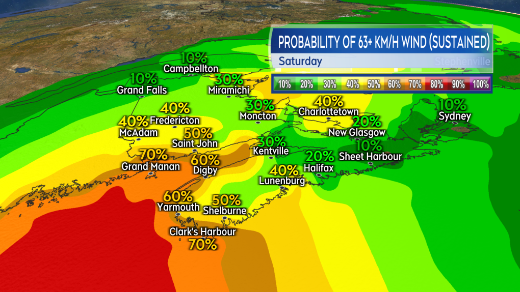 The probability of tropical storm force winds on Saturday. Highest in southwestern Nova Scotia and southwestern New Brunswick. (CTV/Kalin Mitchell)
Stronger wind gusts will be present in a larger area of the Maritimes. The strongest gusts expected in southwestern Nova Scotia and southwestern New Brunswick where they could peak in the range of 80 to 110 km/h, and in excess of 110 km/h on exposed areas of the coastline.
Much of the rest of the Maritimes can expect frequent wind gusts reaching 60 to 80 km/h at times throughout the day and into Saturday night. The prolonged period of high and gusty winds bringing a high risk of power outages, particularly for western Nova Scotia and southwestern New Brunswick.
While the wind is expected to be impactful, it is not expected to match the extremes of hurricane Fiona. It is notable that the more western areas of the Maritimes will catch the strongest of the wind from Lee, where it was more eastern areas of the Maritimes that bore the brunt of Fiona.
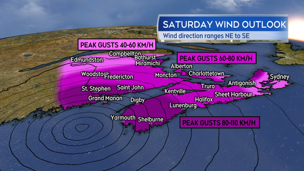 An overview of the peak wind gusts possible in the Maritimes Saturday. Prolonged periods of gusty winds bringing a risk of power outages. (CTV/Kalin Mitchell)The greatest risk of heavy rain on Saturday will be in western New Brunswick. There is a general risk of more isolated downpours in the Maritimes on Saturday due to the tropical nature of the air that is brought in with the storm.
A rough and pounding surf will also be present on parts of the coastline. In the latest information statement from the Canadian Hurricane Centre, they note that areas that are at most risk for impact from that include the “Atlantic coastal mainland Nova Scotia and areas around the Bay of Fundy.”
Further periods of gusty winds and rain are expected on Sunday in the Maritimes as Lee moves slowly into the Gulf of St. Lawrence.
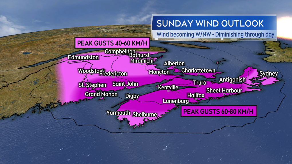 An overview of the peak wind gusts possible in the Maritimes Sunday. The wind is expected to slowly diminish Sunday afternoon and evening. (CTV/Kalin Mitchell) More updates on Hurricane Lee will be available daily on CTV News Atlantic Noon, Five, Six and Late as well as on our website.


CTVNews.ca Top Stories

Canada's most wanted fugitive arrested in P.E.I. in connection with Toronto homicide
A suspect in a fatal shooting in Toronto’s east end last summer has been arrested in Charlottetown, just one week after he topped a list of Canada’s most wanted fugitives.
Plane overshoots runway at airport in St. John's, N.L., no injuries reported
Investigators from the Transportation Safety Board of Canada are headed to St. John's, N.L., after a plane overshot a runway at the city's airport this afternoon.
Concerns about plexiglass prompt inspections at some Loblaws locations in Ottawa
Inspections are underway at more than one Loblaws location in Ottawa after complaints were filed about tall plexiglass barriers.
BREAKING
BREAKING Federal employees will be required to spend 3 days a week in the office
Starting in September, public servants in the core public administration will be required to work in the office a minimum of three days a week. The Treasury Board Secretariat says executives will need to be in the office four days per week.
Poilievre unrepentant over calling Trudeau 'wacko' as his MPs say Speaker should resign
An unrepentant Pierre Poilievre returned to the House of Commons on Wednesday to pepper the prime minister about his drug decriminalization policies after being booted the day prior for refusing to take back calling Justin Trudeau 'wacko' over his approach to the issue.
Five human skeletons, missing hands and feet, found outside house of Nazi leader Hermann Göring
The remains belonged to three adults, a teenager and a newborn baby, according to a statement from the Latebra Foundation, a historical organization based in the Polish city of Gdansk, published Thursday.
Toddler of Phoenix first responder dies after bounce house goes airborne
A two-year-old child died after a strong gust of wind sent the bounce house he was in airborne and into a neighbouring lot in central Arizona, the Pinal County Sheriff's Office said.
NDP Leader Jagmeet Singh confirms his party will support the Liberals' federal budget
NDP Leader Jagmeet Singh says his party will support the federal budget, ending any speculation that the party could pull out of its deal with the minority Liberal government.
Dental care program accepting claims for 1 million seniors
Citizens' Services Minister Terry Beech says 1,200 seniors have already visited a dentist and had their claims processed by the federal government's new dental care plan.
Shopping Trends
The Shopping Trends team is independent of the journalists at CTV News. We may earn a commission when you use our links to shop. Read about us.


Toronto
-
Canada's most wanted fugitive arrested in P.E.I. in connection with Toronto homicide
A suspect in a fatal shooting in Toronto’s east end last summer has been arrested in Charlottetown, just one week after he topped a list of Canada’s most wanted fugitives.
-
Ontario's police watchdog continues probe of high-speed pursuit involving fatal crash
The investigation continues into a collision that killed two grandparents and their infant grandchild during a high-speed police chase on the wrong way of Highway 401 east of Toronto.
-
Ontario woman surprised after 20-year-old fines suddenly tank credit score
An Ontario woman says that she was shocked when fines from 20 years ago suddenly tanked her credit score last week, but the situation may not be as unusual as it seems, according to at least one debt expert.
Calgary
-
Appeal denied for man convicted in 2019 murder in Airdrie, Alta.
The Alberta Court of Appeal has denied the request of an Airdrie man to set aside his murder conviction in the fatal shooting of his neighbour in 2019.
-
West Bragg logging plan damaging to kilometres of trail, recreation groups say
A plan to log 450 hectares of old-growth forest near Bragg Creek, Alta., would significantly damage kilometres of popular trails, say groups representing recreational users.
-
New National Music Centre exhibition celebrates 'Godfather of Canadian Hip-Hop', Maestro Fresh Wes
The career of the Godfather of Canadian Hip-Hop, aka Maestro Fresh Wes, is getting its close-up in a new exhibition that opens May 15 at the National Music Centre.
Edmonton
-

Day parole granted for man convicted of manslaughter in deaths of Métis hunters
A man convicted of manslaughter in the 2020 deaths of two Métis hunters has been granted day parole.
-
'It's very special to me': Oilers superfan shows off collection of a lifetime
Edmonton Oilers superfan Tina Duncan is an avid collector of the team's memorabilia who has transformed her basement into a fan's paradise.
-
Oilers forward Zach Hyman hoping to teach 'Shaq Hyman' how to skate: 'For free'
Oilers forward Zach Hyman hoping to teach 'Shaq Hyman' how to skate: 'For free'
Montreal
-

McGill offers 'forum' with protesters after judge dismisses injunction request
A judge has rejected a request from two McGill University students for a court injunction to limit where protesters can go on campus.
-
Quebec schools must have designated boys and girls bathrooms: education minister
Even though the Quebec advisory committee on gender identity has yet to make its recommendations, Education Minister Bernard Drainville has decided to ban gender-neutral toilets and changing rooms in public schools.
-
Woman killed before Montreal fire, police arrest suspect
A 29-year-old woman has been arrested in the death of a 42-year-old woman in Montreal's Pointe-aux-Trembles district.
Ottawa
-
 BREAKING
BREAKING Federal employees will be required to spend 3 days a week in the office
Starting in September, public servants in the core public administration will be required to work in the office a minimum of three days a week. The Treasury Board Secretariat says executives will need to be in the office four days per week.
-
Concerns about plexiglass prompt inspections at some Loblaws locations in Ottawa
Inspections are underway at more than one Loblaws location in Ottawa after complaints were filed about tall plexiglass barriers.
-
Students launch pro-Palestinian encampment at uOttawa
A group of students has launched an encampment at the University of Ottawa (uOttawa) calling on the institution to cut financial ties with Israel, despite the school warning that such action would not be tolerated.
London
-

Protestors set up tent encampment on campus, Western University says
As protestors set up tent encampments at universities across Canada and the U.S., London, Ont.’s Western University finds itself no exception on Wednesday.
-
'Breaks my heart': Residents react to removal of Canada goose nest, destruction of eggs
Residents who live in the Hyde Park Place apartments in north London, Ont. said they are heartbroken after Old Oak Properties removed two geese nests, containing more than half a dozen eggs.
-
'They were fortunate': No injuries reported in London rollover crash
The collision at the intersection of Gainsborough and Aldersbrook Roads, was forceful enough to flip a grey SUV. A black SUV was also damaged.
Barrie
-

The Barrie Airshow set to take flight over Kempenfelt Bay
The Barrie Airshow is set to take flight above Kempenfelt Bay this summer.
-
Trial set for suspect in 1994 Barrie murder case
The man who police say killed Katherine Janeiro and left her body for friends to find, Robert MacQueen aka Bruce Ellis will stand trial for her murder.
-
Police crack down on auto theft with formation of a new unit in Simcoe County
Barrie Police and South Simcoe Police are joining forces to take on the epidemic of auto thefts.
Northern Ontario
-

Man from Tweed, Ont. selling home due to wife's passing set to face higher capital gains tax
Terry Sutherland is trying to sell his home in Tweed, Ont., but he'll likely be hit by the capital gains tax rise.
-
Baby, grandparents among 4 people killed in wrong-way police chase on Ontario's Hwy. 401
A police chase which started with a liquor store robbery in Bowmanville Monday night ended in tragedy some 20 minutes later when a suspect fleeing police entered Highway 401 in the wrong direction and caused a pileup which killed an infant and the child's grandparents, as well as the suspect, investigators say.
-
Ontario woman surprised after 20-year-old fines suddenly tank credit score
An Ontario woman says that she was shocked when fines from 20 years ago suddenly tanked her credit score last week, but the situation may not be as unusual as it seems, according to at least one debt expert.
Kitchener
-
 BREAKING
BREAKING Ont. woman who faked pregnant to defraud doulas arrested again on similar charges
A Brantford, Ont. woman who was sentenced to house arrest earlier this year for defrauding and deceiving doulas has been arrested again on similar charges.
-
1,428 Waterloo Region high school students suspended over out-of-date vaccination records
Nearly 1,500 Waterloo Region high school students have been suspended over out-of-date vaccination records.
-
More than eight million contraband cigarettes seized by OPP
OPP say two traffic stops in Brant and Haldimand counties resulted in the seizure of 8,422,800 unstamped contraband cigarettes.
Windsor
-

'Shocking breach of trust': Former Windsor denturist sent to jail for sexual assault
A former Windsor denturist is being sent to jail for sexual assault.
-
Gunshots investigated in east Windsor
Windsor police are investigating after multiple shots were fired in east Windsor.
-
Two children injured after getting struck by vehicle while retrieving basketball
Windsor police say two children were taken to hospital after getting hit by a vehicle while retrieving a basketball.
Winnipeg
-

Lawyers for alleged serial killer to argue he is not criminally responsible
Defence lawyers told court they will argue alleged serial killer Jeremy Skibicki is not criminally responsible for the deaths of four Indigenous women by way of a mental disorder.
-
NEW
NEW Interprovincial drug bust led by Winnipeg police turns up millions in drugs, cash, luxury goods
More than a dozen people are facing charges, the majority Winnipeggers, after an interprovincial drug bust that turned up millions of dollars in cash, drugs, guns, jewelry and luxury vehicles.
-
Manitoba providing money for memorial to honour Carman homicide victims
The provincial government is providing funding to the Town of Carman to honour the five people who were killed in February, and to help those who helped the town heal.
Regina
-

Here's how one of Sask.'s largest power plants was knocked out for 73 days, and what it took to fix it
A group of SaskPower workers recently received special recognition at the legislature – for their efforts in repairing one of Saskatchewan's largest power plants after it was knocked offline for months following a serious flood last summer.
-
These driving offences now come with an automatic impoundment, licence suspension in Sask.
Drivers in Saskatchewan will now lose their licence for a week and their vehicle for a month if they are caught committing certain high-speed and dangerous offences on the road.
-
Managers must tell new hires about risk of violence at work under new Sask. employment rules
Saskatchewan employers will be required to tell new hires if they face a risk of violence in the workplace and to take actions against it starting on May 17.
Saskatoon
-

'Not an easy task': Police begin 'meticulous' search at Saskatoon landfill in Mackenzie Trottier case
Police officers and cadaver dogs have begun searching the Saskatoon landfill for answers in the Mackenzie Lee Trottier case.
-
Managers must tell new hires about risk of violence at work under new Sask. employment rules
Saskatchewan employers will be required to tell new hires if they face a risk of violence in the workplace and to take actions against it starting on May 17.
-
High school students gear up for Robot Rumble at Sask. Polytech
High school students from across the province are gearing up for a battle of technical skills in the annual Robot Rumble at Sask. Polytechnic on Thursday.
Vancouver
-

Police arrest woman who praised Hamas attack at Vancouver protest
Authorities have arrested a 44-year-old woman who praised last October's attack on Israel during a rally in downtown Vancouver.
-
B.C. tribunal decides first case involving non-consensual sharing of intimate images
In a first-of-its-kind case, a B.C. tribunal has ruled on a dispute involving the non-consensual sharing of intimate images, awarding damages and issuing orders that the photos be destroyed and taken offline.
-
8-year sentence after guilty plea in 2022 Surrey shooting case
A drug dealer who shot his customer in the chest over an unpaid debt in 2022 has been sentenced to eight years in prison for manslaughter.
Vancouver Island
-

Gaza protesters at University of Victoria say encampment will stay until demands are met
A pro-Palestinian protest camp has formed at the University of Victoria in solidarity with the people of Gaza and with similar encampments that have sprung up on university and college campuses in opposition to the Israel-Hamas war.
-
'Floatel' won't be allowed to house LNG workers near Squamish, B.C.
Plans to use a renovated cruise ship to house more than 600 workers as they build a liquefied natural gas facility near Squamish, B.C., have been voted down by the local council.
-
Victoria police say speed a factor in crash that seriously injured driver
Investigators say speed was likely a contributing factor in a single-vehicle crash that sent a driver to hospital with serious but non-life-threatening injuries in Victoria.
Kelowna
-

B.C. breweries take home awards at World Beer Cup
Out of more than 9,000 entries from over 2,000 breweries in 50 countries, a handful of B.C. brews landed on the podium at the World Beer Cup this week.
-
B.C. man rescues starving dachshund trapped in carrier: BC SPCA
An emaciated dachshund is now recovering thanks to a Good Samaritan who found the pup near a biking trail in Kelowna, according to the BC SPCA.
-
Search crews called in after missing Kelowna senior's truck found
Search and rescue crews have been called in after a vehicle belonging to a missing senior was located near a rural intersection outside of Kelowna Tuesday.


