Tropical Storm Bret bears down on Caribbean islands, second storm developing behind
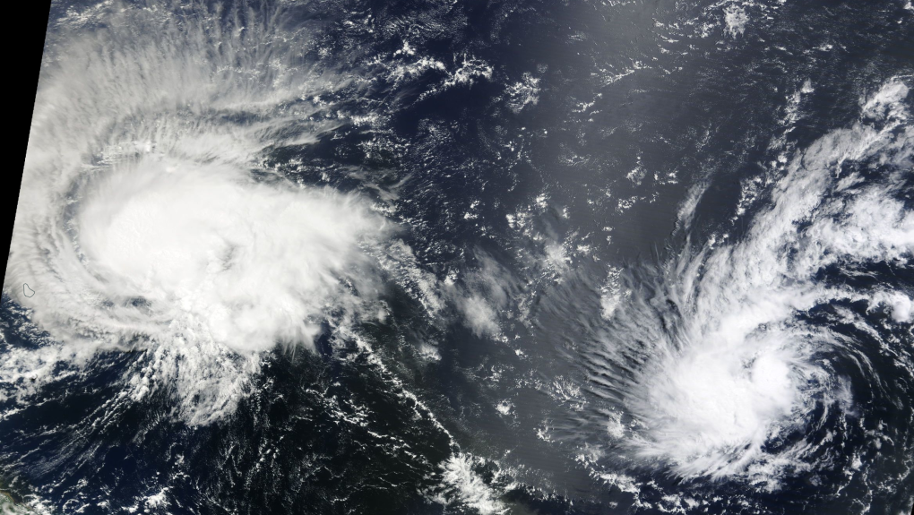
 Tropical Storm Bret and Tropical Depression Four on satellite imagery courtesy of NASA. Bret is the larger storm on the left and Four is the smaller storm on the right.
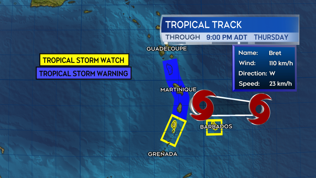
Tropical Storm Bret continues as a strong tropical storm with maximum sustained winds near 110 km/h, just shy of category one hurricane strength.
The storm will move across the Lesser Antilles, a group of islands on the eastern Caribbean Sea, Thursday evening.
St. Lucia is under both a tropical storm warning and a hurricane watch. A tropical storm warning is in effect for Martinique and Dominica and tropical storm watches extend to Barbados and St. Vincent.
Bret threatens parts of the islands with rain that could range 75 to 200 mm. Tropical storm force winds are a risk for those island under the warnings. Dangerous surf and rip tides are also expected upon and following the storms passage.
After passing through the island group, Bret is forecast to continue moving westward into the Caribbean Sea as a tropical storm on Friday.
 Tropical Storm Bret is forecast to cross the Lesser Antilles on Thursday evening.
To the east of Bret, Tropical Depression Four has developed.
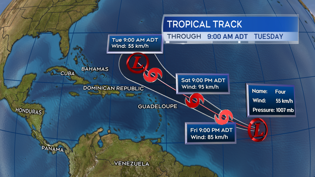
The storm is forecast to continue to strengthen while moving northwestward into Friday. Once it reaches tropical storm strength it will be named Cindy. The system is forecast to move to a position east of the Bahamas by early next week as a tropical storm or tropical depression.
There is no imminent risk from either storm to the Maritimes or Atlantic Canada. The more northerly movement of Tropical Depression Four does mean we may need to watch the remnants of that system closely next week.
 Tropical Depression Four is likely to become Tropical Storm Cindy. The storm taking a northwestward path that will place it east of the Bahamas early next week.
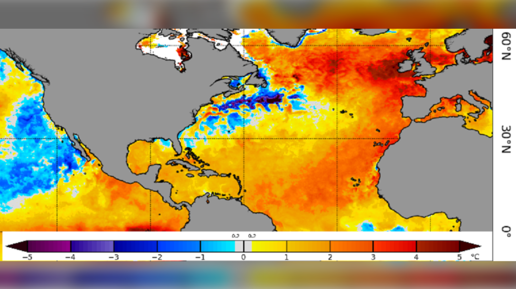
The start of hurricane season has been unusually active in the tropical Atlantic. That area typically has more frequent development later in the season in late summer and early fall. A contributing factor is unusually warm Atlantic Ocean waters, much of the southern Atlantic is currently sitting one to three degrees above average.
The presence of these warmer waters and the favourable conditions they create for tropical storms and hurricanes was noted in the forecast for the hurricane season this year.
 Sea surface temperature anomaly courtesy of the National Atmospheric and Oceanic Administration. Much of the Atlantic is anomalously warm.
CTVNews.ca Top Stories

Five years after toddler's brutal death, Northern Ont. family struggles to find peace, justice
A North Bay family is struggling to find peace and justice as the five-year anniversary of the brutal death of toddler Oliver McCarthy approaches.
Alberta RCMP officer charged with 2 counts of sexual assault
Const. Bridget Morla, a Leduc RCMP officer, has been charged with two counts of sexual assault in connection with an incident that happened two years ago.
Ontario dad removes hockey rink at heart of neighbour dispute
A Markham dad who drew the ire of neighbours and the city after installing a hockey rink in his backyard says the rink has now been taken down.
Kingston, Ont. doctor in 'disbelief' after being ordered to repay $600K for pandemic vaccination payments
An Ontario health tribunal has ordered a Kingston, Ont. doctor to repay over $600,000 to the Ontario government for improperly billing thousands of COVID-19 vaccinations at the height of the pandemic.
Three climbers from the U.S. and Canada are missing on New Zealand's highest peak
Three mountain climbers from the U.S. and Canada are missing after they failed to return from a planned ascent of New Zealand's highest peak, Aoraki, authorities said Tuesday.
Motivated by obsession: Canadians accused in botched California murder plot in police custody
Two Canadians are in police custody in Monterey County, California, after a triple stabbing police say was motivated by a B.C. man's obsession with a woman he played video games with online.
Trump demands immediate release of Oct. 7 hostages, says otherwise there will be 'HELL TO PAY'
President-elect Donald Trump is demanding the immediate release of the Israeli hostages still being held in Gaza, saying that if they are not freed before he is sworn into office there will be “HELL TO PAY."
Belly fat linked to signs of Alzheimer’s 20 years before symptoms begin, study says
As the size of a person’s belly grows, the memory centre of their brain shrinks and beta amyloid and tau may appear — all of this occurring as early as a person’s 40s and 50s, well before any cognitive decline is apparent, according to new research.
More RCMP and CBSA ‘human resources’ destined for border, Public Safety Minister LeBlanc says
Public Safety Minister Dominic LeBlanc says the federal government will 'absolutely' be adding more Canadian Border Services Agency (CBSA) and RCMP ‘human resources’ at the border.


