Severe thunderstorm watch issued in New Brunswick, rainy start to the weekend
Friday thunderstorms
After a cloudy, showery start to the day, the northwest of New Brunswick will get into some afternoon sunny breaks Friday. As the sun shines through, warmth and humidity builds, creating a buoyant atmosphere favourable for thunderstorms. A cold front approaching from over the St. Lawrence River Valley in Quebec will provide the trigger to get those thunderstorms going.
The area with the highest risk of thunderstorms Friday afternoon into evening runs approximately between Perth–Andover and Woodstock in the west and then continues to Fredericton and into the northeast, including Campbellton-Dalhousie, Bathurst, the Acadian Peninsula, and Miramichi.
The period of time at highest risk extends from 2 p.m. to about 9 p.m. After 9 p.m., thunderstorms that do develop should have ended or be weakening.
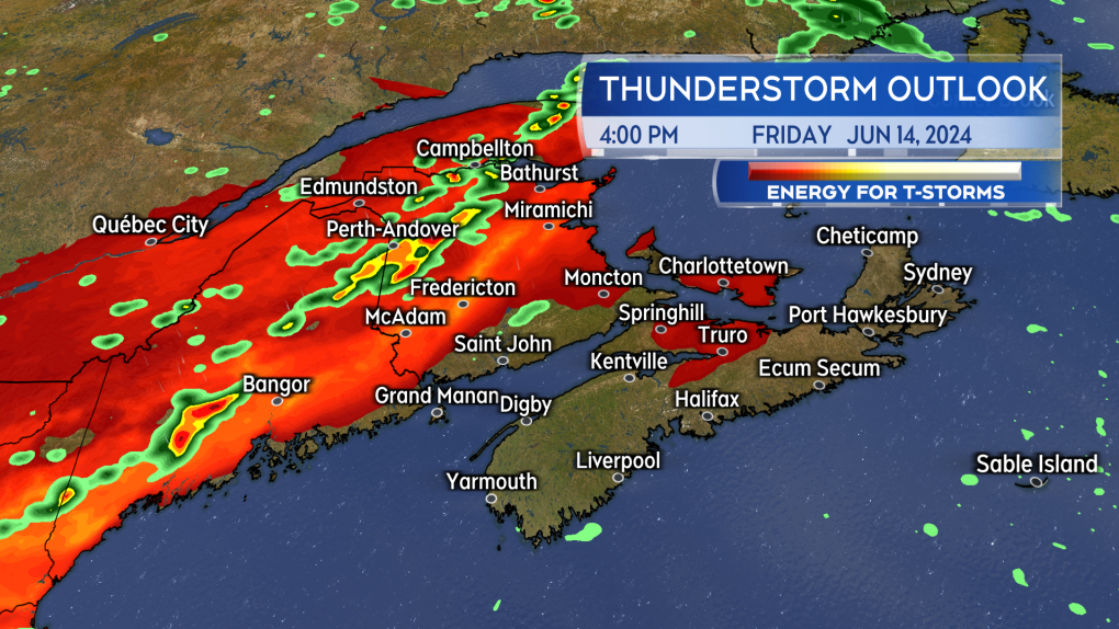 Conditions favour the development of potentially severe thunderstorms in New Brunswick Friday afternoon.
A severe thunderstorm watch was issued for much of northwestern New Brunswick near noon on Friday. Environment Canada cautions the thunderstorms could produce rain rates of 25 mm per hour and wind gusts of 70 to 90 km/h. Be weather aware and remember when thunder roars head indoors. The situation with thunderstorms changes rapidly. Have a way to monitor the latest watch/warnings issued by Environment Canada.
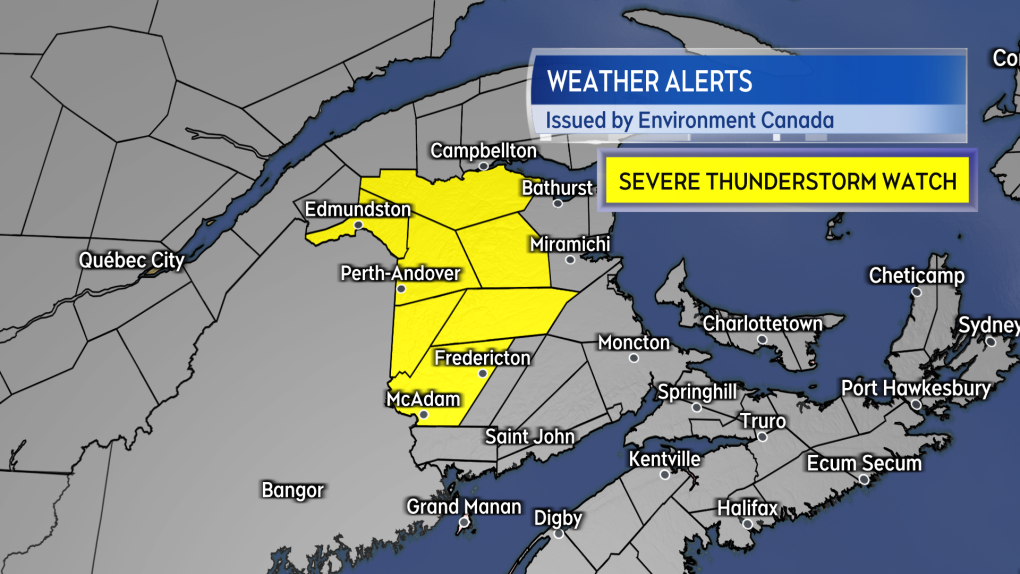 A severe thunderstorm watch issued by Environment Canada near noon on Friday.
Weekend rain
Cloud will be increasing for the Maritimes Friday night. Patchy showers and drizzle will develop in the region by midnight. An early Saturday morning round of rain that moves across the southwest of Nova Scotia, Bay of Fundy coastline in New Brunswick, and into Prince Edward Island could include embedded thunderstorms.
A second round of rain will move across Nova Scotia and P.E.I. Saturday morning and afternoon. The rain will be clearing mainland Nova Scotia and P.E.I. by Saturday evening. The rain will be clearing Cape Breton through the evening.
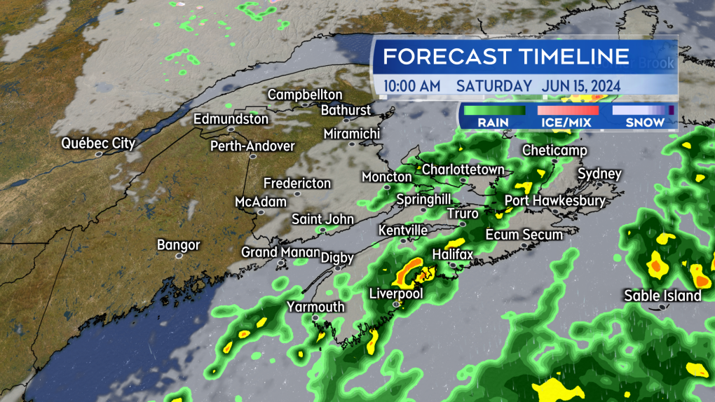 Bands of rain cross the Maritimes on Saturday. Communities in southeastern New Brunswick, P.E.I., and Nova Scotia are most likely to catch them.
Rain amounts expected
Rain totals are going to be highly varied across the Maritimes Friday through Saturday. Communities that catch thunderstorms or some of the steadier rain could pick up rain amounts of 10 to 40 mm. Areas that just see showers or lighter, intermittent rain will see as little as a few to several millimetres.
Areas that have a higher chance of rain amounts 10 mm or more include southeastern New Brunswick, central and eastern P.E.I., and Nova Scotia in general.
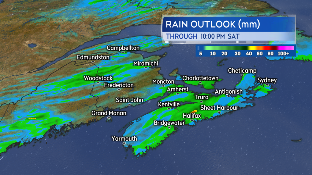 Varied rain totals from the showers and rain Friday into Saturday. Some as little as a few millimetres and others 10 to 40 mm.


CTVNews.ca Top Stories

'Why did I have this surgery?' Ont. mother seeks answers after son's tonsil surgery
An Ontario mother said it looked like a horror movie when she flicked on the lights of her son’s bedroom to find him projectile vomiting blood after his tonsils were removed at McMaster Children’s Hospital.
'Deeply unserious': Vancouver councillor claims mayor turned city hall boardroom into gym
A Vancouver city councillor is calling out Mayor Ken Sim for apparently limiting access to a city hall boardroom and turning it into a makeshift gym.
No charges for driver in 2023 Manitoba bus crash that killed 17 seniors: RCMP
Manitoba RCMP and Crown prosecutors will not lay charges against the driver of a bus involved in a crash with a semi-truck in 2023.
Sask. Party catches heat after using Russian filmed stock footage in campaign ad
The Saskatchewan Party is facing criticism for a pre-election campaign ad. It featured video portraying Saskatchewan's scenery but contained some footage actually filmed in Russia.
Things a pediatrician would never let their child do
As summer begins for most children around Canada, CTV News spoke with a number of pediatric health professionals about the best practices for raising kids, and how the profession has evolved since the COVID-19 pandemic.
Elvis Presley's actual blue suede shoes are up for auction
Now, fans have the opportunity to step into the King’s very own blue suede shoes as they go up for grabs at British auction house Henry Aldridge and Son.
Ohio jail mistakenly frees suspect in killing because of a typo
A man awaiting trial on an aggravated murder charge was mistakenly released from a county jail in Ohio this week due to a clerical error, authorities said.
Biden pardons potentially thousands of ex-service members convicted under now-repealed gay sex ban
U.S. President Joe Biden pardoned potentially thousands of former U.S. service members convicted of violating a now-repealed military ban on consensual gay sex, saying Wednesday that he is “righting an historic wrong" to clear the way for them to regain lost benefits.
Gassy cows and pigs will face a carbon tax in Denmark, a world first
Denmark will tax livestock farmers for the greenhouse gases emitted by their cows, sheep and pigs from 2030, the first country to do so as it targets a major source of methane emissions, one of the most potent gases contributing to global warming.
Shopping Trends
The Shopping Trends team is independent of the journalists at CTV News. We may earn a commission when you use our links to shop. Read about us.


Toronto
-
'Why did I have this surgery?' Ont. mother seeks answers after son's tonsil surgery
An Ontario mother said it looked like a horror movie when she flicked on the lights of her son’s bedroom to find him projectile vomiting blood after his tonsils were removed at McMaster Children’s Hospital.
-
Automatic Ontario licence plate renewals start Canada Day
Ontario drivers in good standing won’t have to worry about renewing their licence plates starting Canada Day.
-
Home invasion suspect fled empty handed after being stabbed during struggle with victim: police
An arrest has been made in connection with a botched home invasion in Toronto’s west end last month that ended with the suspect fleeing empty-handed after sustaining a stab wound, police say.
Calgary
-

WestJet mechanics issue strike notice for possible job action Friday
WestJet says it faces a possible strike by its mechanics starting as early as Friday.
-
Man found in Bow Valley Provincial Park was murdered, RCMP say
Alberta RCMP are looking for the public's help to identify a man whose body was found in Bow Valley Provincial Park last November.
-
Shell going ahead with Alberta carbon capture projects
Shell Canada Products says it's going ahead with its Polaris carbon capture project in Alberta.
Edmonton
-

Smith tells Trudeau Alberta will opt out of federal dental plan
Alberta is opting out of the federal dental plan, the premier told the Canadian government late Tuesday afternoon.
-
Convicted sexual offender to live in Edmonton, police warn
Edmonton police are warning the public about the release of a convicted sexual offender into the city who they believe could offend again.
-
Police investigating at 82 Avenue apartment building
Police taped off the entrance to an apartment building east of Whyte Avenue early Wednesday morning.
Montreal
-

Companies face confusion as they prepare for Quebec's new language rules next year
In just under a year's time, important pieces of the new French language law are set to come into force for companies operating in Quebec. Although many are preparing for the laws to be applied, the future requirements are still causing some stress, notably because of the paperwork involved and what some say is a lack of clarity.
-
Here are the 10 most dangerous intersections for Montreal cyclists
Researchers out of McGill University say there is a critical need for safer cycling infrastructure around certain intersections in Montreal after pinpointing 10 troubling spots in a recent survey.
-
Teen driver, passenger in hospital after crash in Montreal's West Island
Two people are in hospital, including a teenage driver, after a crash on Highway 20 in Beaconsfield in Montreal's West Island.
Ottawa
-
Man facing charges for allegedly threatening Ottawa Coun. Plante, police say
An Ottawa man is facing charges of uttering threats and harassment after allegedly making threats towards Ottawa-Vanier Coun. Stephanie Plante.
-
Royal Canadian Air Force to hold practice flypast over Ottawa on Wednesday ahead of Canada Day
The Royal Canadian Air Force (RCAF) will hold a flypast over downtown Ottawa and LeBreton Flats on Wednesday, as part of preparations for Canada Day. Aircraft are scheduled to fly over Ottawa between 12 p.m. and 3 p.m.
-
Here's a look at the Ottawa Senators new jersey for next season
The National Hockey League and Fanatics released images of the Fanatics Authentic Pro NHL on-ice uniforms for the Senators and all NHL clubs Wednesday morning.
London
-

Vast majority of London’s parkland now off limits to homeless encampments
Londoners experiencing homelessness must now navigate a more complex and restrictive set of rules about where they can set up a tent or make-shift shelter.
-
Trees topple in some London neighbourhoods after brief storm blows through
CTV London Meteorologist Julie Atchison said sunshine will start your Tuesday, 'A nice mix of sun and cloud, winds picking up out of the south as we head into the afternoon.'
-
Council rebuffs Farhi Holdings’ land deal and confirms plan to build new city hall on current property
A last ditch effort to investigate constructing a new city hall building in the heart of downtown London was shot down by a majority of city council.
Barrie
-

Barrie police officer makes court appearance for 2nd discreditable conduct charge
A high-ranking Barrie Police Service officer facing a second count of discreditable conduct made her first appearance in a virtual Police Services Act hearing Wednesday morning.
-
$600K worth of stolen goods retrieved during Huron-Perth bust
One man has been charged with possession of a stash of stolen goods and machinery.
-
Emotions high as family confronts Aurora man convicted of killing his wife
The Aurora man convicted in the death of his wife sat in a courtroom on Tuesday while his family gave emotional victim impact statements ahead of his sentencing.
Northern Ontario
-
North Bay area police investigating bag of dead puppies
Ontario Provincial Police are asking the public for help identifying a suspect after a bag of dead puppies washed ashore in a creek in the North Bay area earlier this month.
-
One of Canada's most popular vehicles recalled over transmission issue; 95,000 impacted
One of the country's most popular vehicles is being recalled in Canada due to a transmission issue that may impact tens of thousands of drivers.
-
Indigenous burial grounds in northern Ont. to be protected
Ancient burial grounds in the Town of Blind River will soon be marked, and blocked off to the public.
Kitchener
-

Pedestrian from Waterloo dies in crash near Milverton, Ont.
A Waterloo resident has died following a Tuesday night crash north of Milverton, Ont.
-
University of Waterloo takes legal action to remove Occupy UW encampment
An ongoing dispute between the University of Waterloo and a pro-Palestinian encampment has turned into a legal battle.
-
Two Southwestern Ontario players are now Stanley Cup champions
The Florida Panthers have made NHL history and two of their players, who call Southwestern Ontario home, are now celebrating their first big Stanley Cup win.
Windsor
-

OPP release names in death investigation in Harrow
Essex County OPP have released the names of four family members in an ongoing death investigation in Harrow.
-
School board meeting shut down, police called over disruptions
A special meeting of the Greater Essex County District School Board (GECDSB) was dissolved after numerous disruptions from members of the public.
-
Video appears to show vehicle T-boned by school bus at red light
Three students were on a school bus that allegedly ran a red light, colliding with an SUV passing through an intersection on June 19.
Winnipeg
-

No charges for driver in 2023 Manitoba bus crash that killed 17 seniors: RCMP
Manitoba RCMP and Crown prosecutors will not lay charges against the driver of a bus involved in a crash with a semi-truck in 2023.
-
Winnipeg firefighters rescue two trapped inside apartment during fire
A Wednesday morning fire at an apartment building in Winnipeg has sent two people to the hospital.
-
Métis music legend Ray St. Germain dead at 83
A well-known Metis musician has died after a years-long battle with Parkinson’s disease.
Regina
-

Walk of Fame inductee Tatiana Maslany celebrated in 'Hometown Stars' event
Award winning actor Tatiana Maslany is set to be honoured today at a special Canada's Walk of Fame 'Hometown Stars' event in Regina.
-
Sask. Party catches heat after using Russian filmed stock footage in campaign ad
The Saskatchewan Party is facing criticism for a pre-election campaign ad. It featured video portraying Saskatchewan's scenery but contained some footage actually filmed in Russia.
-
Court hears from victim and mother at trial for Regina teacher accused of sexually exploiting student
High emotions filled a Regina courtroom on the second day of a trial for a former Regina teacher accused of sexually exploiting a female student.
Saskatoon
-

'The federal government can't interfere': Sask. will not comply with federal clean electricity regulations
The Government of Saskatchewan announced that it will not comply with the incoming federal clean electricity regulations.
-
Judge rejects Saskatoon mayoral candidate's lawsuit to halt housing accelerator changes
A judge has rejected a Saskatoon mayoral candidate’s bid for a court injunction on zoning changes required for the city to access federal housing accelerator funds.
-
Sask. Party catches heat after using Russian filmed stock footage in campaign ad
The Saskatchewan Party is facing criticism for a pre-election campaign ad. It featured video portraying Saskatchewan's scenery but contained some footage actually filmed in Russia.
Vancouver
-

'Deeply unserious': Vancouver councillor claims mayor turned city hall boardroom into gym
A Vancouver city councillor is calling out Mayor Ken Sim for apparently limiting access to a city hall boardroom and turning it into a makeshift gym.
-
Families hold rally calling for rebuild of Port Coquitlam school destroyed in fire
Eight months since a devastating fire ripped through Hazel Trembath Elementary School in Port Coquitlam, the lot now sites empty with gravel.
-
Meet the centenarians: Canada's oldest age group is also its fastest-growing
Vi Roden said she reads an average of 50 books a year, attends history lectures at her local seniors centre, and does yoga twice a week.
Vancouver Island
-

Meet the centenarians: Canada's oldest age group is also its fastest-growing
Vi Roden said she reads an average of 50 books a year, attends history lectures at her local seniors centre, and does yoga twice a week.
-
Critically endangered Vancouver Island marmots released into the wild
Volunteers carried cages containing very rare furry creatures up Mount Washington on Monday as part of the mission to save Canada’s most endangered mammal.
-
B.C. Green MLA Adam Olsen won't seek re-election, citing 'existential re-evaluation'
British Columbia Green Party MLA Adam Olsen will not seek re-election this year, the two-term member of the legislature announced Tuesday, citing "an existential re-evaluation of what is truly important to me."
Kelowna
-

Man stabbed in Kelowna, suspect at large: RCMP
Mounties in Kelowna say a suspect is at large after a man was stabbed in the city Sunday afternoon.
-
Police still investigating cause after woman found dead in Kelowna park
Police are remaining tight-lipped about a woman’s death in a Kelowna park on Friday.
-
Man shot dead in Princeton, B.C., was high-ranking gang member, court records suggest
Police have identified a man found dead in B.C.’s Interior last weekend as Donald “Donnie” Lyons.


