A fair, dry weekend for the Maritimes followed by a rainy start to May
 A couple takes advantage of fine spring weather as they walk their dogs on Conrad's Beach, in Lawrencetown, N.S. on Friday, May 7, 2010. (THE CANADIAN PRESS/Andrew Vaughan)
With a ridge of high pressure building in from the west, just a few clouds and some fog patches are expected Friday night — followed by largely fair weather for the weekend ahead.
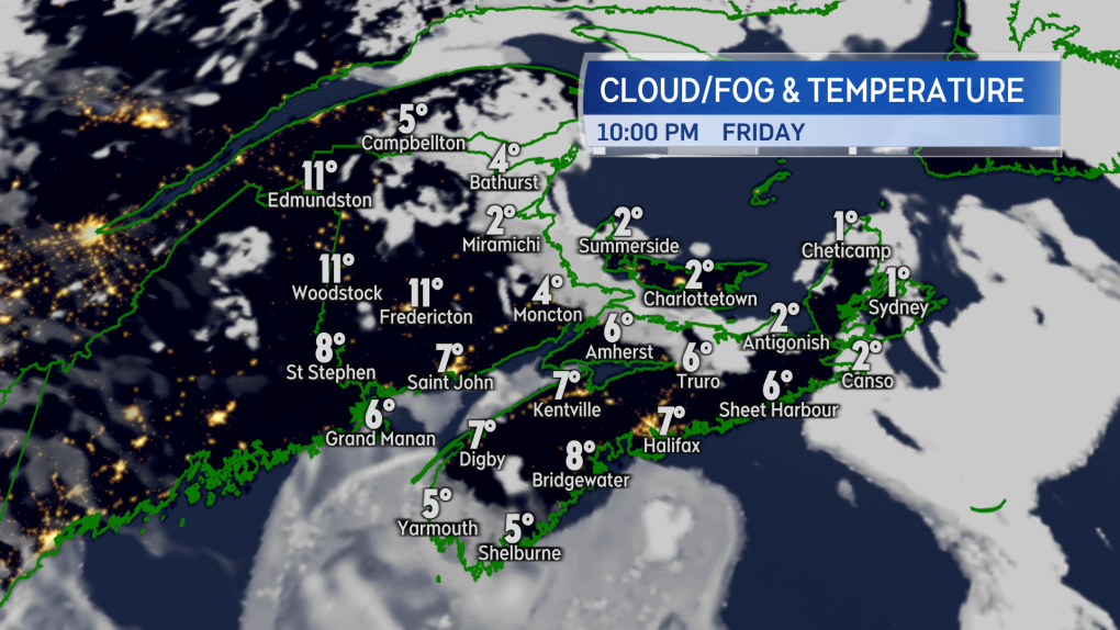 A few clouds along with fog patches developing overnight for the Maritimes Friday night.
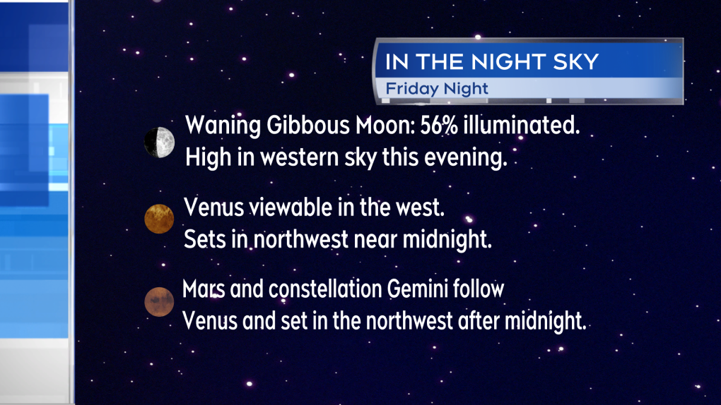
We’ve had a few Friday nights in a row now with decent conditions for night sky viewing and Friday night is another. If you wanted to do some star/planet gazing, here are a few things you can spot:
- The Waxing Gibbous Moon is 56 per cent illuminated and will be high in the western sky this evening.
- Look just to the left of the Moon to spot the star Regulus, part of the constellation Leo.
- The planet Venus will set in the northwest near midnight.
- Mars and the constellation Gemini follow Venus in the night sky and set a few hours later.
- There was a spectacular display of the aurora last weekend, though it’s not expected to repeat this weekend. The latest forecast from the Space Weather Prediction branch of the NOAA only has minor geomagnetic storm conditions forecast for this weekend. The geomagnetic storm that produced the aurora last weekend was rated as severe.
 A few things to spot in the night sky this evening. Viewing conditions should be decent for most.
After some morning fog dissipates, a mix of sun and cloud is expected Saturday. Most of the cloud will be high and most widespread around western areas of New Brunswick and southwestern areas of Nova Scotia.
High temperatures will reach the low-to-mid teens for many but remain a bit cooler, 8C to 12C, for P.E.I. and eastern areas of Nova Scotia including Cape Breton. The UV index rated 6 or 7, which is high.
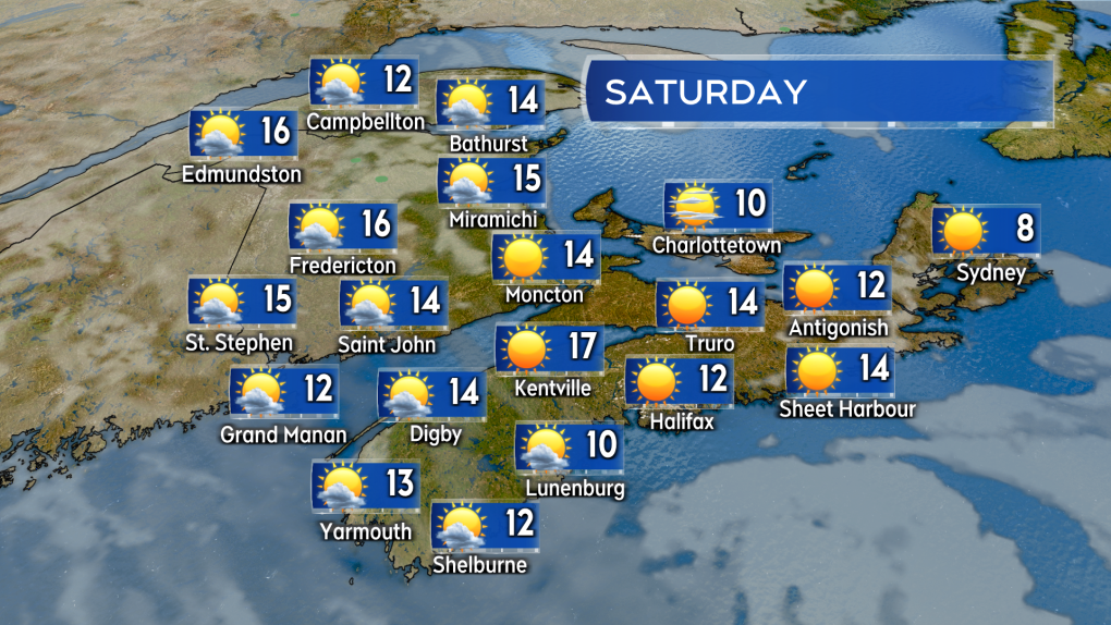 Mostly sunny or a fair weather mix of sun and cloud across the Maritimes on Saturday.
The ridge of high pressure breaks down on Sunday allowing for increasing cloudiness from the west. Most high temperatures should still reach the low-to-mid teens though a bit cooler on the coast and in Cape Breton. Wind will be from the south/southeast, sustained 10 to 20 km/h with gusts 20 to 40 km/h. A larger change in the weather arrives Sunday night into Monday morning.
A weather front off of a low-pressure system centred around Ontario and Quebec will bring the Maritimes a round of rain and gusty weather. Rain will start for western New Brunswick and southwestern Nova Scotia Sunday night.
The rest of the Maritimes will see the rain develop Monday morning and afternoon. Rain persists into Monday night but eases to a chance of showers for Tuesday.
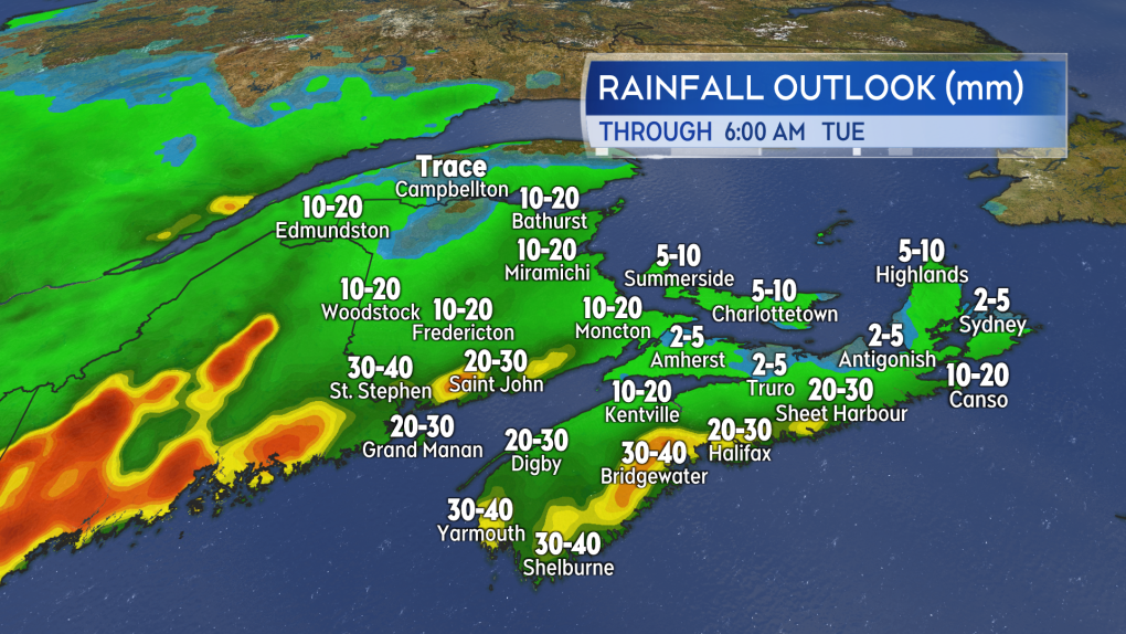 What looks like a general rainfall of 10 to 30 mm is expected Monday for the Maritimes. There is a chance of some locally higher amounts in the southwest of New Brunswick and near the Atlantic coastline of Nova Scotia.
A general 10 to 30 mm of rain looks possible out of that system. Local totals exceeding 30 mm may be possible with the chance of that highest around the Bay of Fundy coastline in New Brunswick and the Atlantic coastline of Nova Scotia. This is a needed rain for the region as we are running a deficit when it comes to total precipitation through the months of March and April.
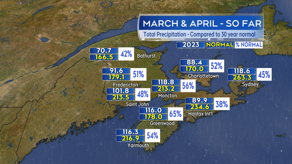 A bit of rain would be welcome. We are currently running drier than 30-year averages when it comes to total March and April precipitation.
Forecast updates and regional weather conditions on CTV News Atlantic Five, Six, and 11:30 PM.


CTVNews.ca Top Stories

Tropical Storm Milton could hit Florida as a major hurricane midweek
People across Florida were given notice Sunday that Milton, for now just a tropical storm off the coast of Mexico, could intensify rapidly into a major hurricane before slamming midweek into the storm-ravaged Gulf Coast.
Looking for cheap flights for the holidays? Here are some tips to remember
Travelling on a budget can be stressful, but there are ways you can ensure you're getting the best deal on flights as the holiday season approaches.
Officer arrested after allegedly stealing alcohol from store: TPS
A Toronto police officer has been arrested after allegedly stealing three bottles of alcohol from a store.
Son charged with mother's murder on Vancouver Island
Police on Vancouver Island have made an arrest in the case of a 78-year-old woman found dead in her home almost two years ago.
Trump ramps up his campaign in Wisconsin, where a Republican win could knock out Democrats
Donald Trump's fourth scheduled stop in eight days in Wisconsin is a sign of his increased attention as Republicans fret about the former president's ability to match the Democrats' enthusiasm and turnout machine.
Liberal, Conservative MPs to speak at Oct. 7 march to Parliament Hill
A Liberal MP and a Conservative MP will be part of a team delivering speeches at an event in Ottawa commemorating the one year anniversary of the attacks on Oct. 7.
Police ID mom, daughter killed in Old Montreal; video shows person break into building before fatal fire
Police released the identities of the mother and daughter who were killed after a fire tore through a 160-year-old building in Old Montreal on Friday.
opinion
opinion Tips on managing your financial stress
Financial strain can be an uncomfortable burden to bear, especially if you feel that you're doing as much as you can and are barely managing to stay afloat. Personal finance contributor Christopher Liew shares some tips for managing financial stress and digging your way out of debt.
'Sober curious': Younger Canadians turning away from alcohol, data says
According to a survey on recent alcohol consumption, younger Canadians are more likely to have not had a drink in the past week. For those interested in slowing or stopping their alcohol consumption, there's a phrase: 'sober curious.'
Shopping Trends
The Shopping Trends team is independent of the journalists at CTV News. We may earn a commission when you use our links to shop. Read about us.


Toronto
-

Ontario Science Centre to open up temporary satellite locations months after sudden shutdown
The Ontario Science Centre is set to launch two temporary satellite locations in other parts of Toronto, which could let visitors access some of its interactive exhibits while a full interim location remains at least a year away, CTV News has learned.
-
Fans cheer Messi as Toronto FC concedes late goal to Miami and misses out on playoffs
Leo Campana's stoppage-time goal gave Inter Miami a 1-0 win and left Toronto FC's playoff hopes hanging by a thread Saturday.
-
'Sober curious': Younger Canadians turning away from alcohol, data says
According to a survey on recent alcohol consumption, younger Canadians are more likely to have not had a drink in the past week. For those interested in slowing or stopping their alcohol consumption, there's a phrase: 'sober curious.'
Calgary
-

Serious crash impacts traffic on northbound Deerfoot Trail
Emergency crews are on scene of a multi-vehicle collision along northbound Deerfoot Trail near 17 Avenue Southeast.
-
Pro-Palestinian rally at Calgary City Hall ahead of first anniversary of October 7 Hamas attack on Israel
The first anniversary of the October Seventh Hamas attack on Israel is Monday and that prompted several hundred people to attend a pro-Palestinian rally Saturday afternoon at city hall.
-
Roughriders edge Elks 28-24, clinch playoff berth
The Saskatchewan Roughriders have clinched a playoff spot thanks to a win over the Edmonton Elks.
Edmonton
-

Roughriders edge Elks 28-24, clinch playoff berth
The Saskatchewan Roughriders have clinched a playoff spot thanks to a win over the Edmonton Elks.
-
Crash between motorcycle and van closes Highway 39 near Warburg
Highway 39 near Warburg was closed Saturday after a serious crash involving a motorcycle and a van.
-
'We're losing billions of birds': Backyard risks to Alberta's birds and how you can help make fall migration a successful one
An estimated four billion birds will navigate man-made environments as they travel south from North America during fall migration. Tens of million of them will die en route due to human-created hazards.
Montreal
-

Police ID mom, daughter killed in Old Montreal; video shows person break into building before fatal fire
Police released the identities of the mother and daughter who were killed after a fire tore through a 160-year-old building in Old Montreal on Friday.
-
In its 25th season, Quebec satirical news show 'Infoman' is still going strong
The Quebec satirical news show 'Infoman' is still going strong as it marks its 25th season.
-
Police boosting presence in Montreal ahead of Oct. 7 anniversary of Israel-Hamas war
Montreal police say they are increasing their presence across the city ahead of the one-year anniversary of the Oct. 7 start of the Israel-Hamas war.
Ottawa
-

Pro-Palestinian march held in Ottawa amid global day of protests
Demonstrators converged on downtown Ottawa Saturday afternoon as part of a global day of action to protest Israel's military actions in the Middle East.
-
Three injured, including child, in rural south Ottawa crash
Three people were taken to hospital after a crash between a pickup truck and a car in a rural part of Ottawa's south end on Saturday afternoon.
-
Frost advisory issued with temperatures expected to drop near freezing in Ottawa
Environment Canada has issued a frost advisory as temperatures across Ottawa and eastern Ontario are expected to dip near the freezing mark this evening.
London
-

Sarnia considers green bins, reducing garbage collection frequency
Presently, the city is developing a waste master plan, which hopes to reduce the amount of trash going to landfills, and the introduction of green bins and organics collection.
-
Want to catch some fall colours? Be patient
If you’re keen to catch some of the brightest colours that mother nature has to offer this fall, you’re going to be waiting a bit longer.
-
Here are some local coaches getting love from their community
CTV London's Bright Side team asked you to nominate local coaches to be appreciated, and you did not disappoint.
Barrie
-

Police search for missing Orillia man
OPP are seeking assistance in their search for a 30-year-old man last seen in Orillia.
-
Highway 400 crash near Waubaushene under investigation
Provincial police are investigating a collision along Highway 400 in Tay Township Friday afternoon.
-
'InnisFALL' celebrated in Innisfil
More than a thousand residents attended the Town of Innisfil's inaugural 'InnisFALL' festival on Saturday, which celebrated the spirit of fall with live music and entertainment at Innisfil Town Square.
Northern Ontario
-

Liberal, Conservative MPs to speak at Oct. 7 march to Parliament Hill
A Liberal MP and a Conservative MP will be part of a team delivering speeches at an event in Ottawa commemorating the one year anniversary of the attacks on Oct. 7.
-
'Sober curious': Younger Canadians turning away from alcohol, data says
According to a survey on recent alcohol consumption, younger Canadians are more likely to have not had a drink in the past week. For those interested in slowing or stopping their alcohol consumption, there's a phrase: 'sober curious.'
-
No injuries reported in Greater Sudbury garage fire
Fire crews in Greater Sudbury battled a large garage fire on Friday.
Kitchener
-

One injured after small plane crash lands in Brussels
The Huron Ontario Provincial Police said they responded to a “downed airplane” just after 11 a.m. Saturday.
-
One person sprayed with 'noxious substance' in Cambridge
Police say they were called to the area of Simcoe Street and Market Street around 1:30 a.m. Saturday for a report of an assault.
-
Urgent call for volunteers for Oktoberfest parade
The Oktoberfest Parade is fast approaching and organizers are urgently seeking volunteers to fill the role of sign carriers.
Windsor
-

County Road 18 in Harrow closed due to collision
Currently, County Road 18 is closed between Briton Road, and Rizzo Nicola Drive while police investigate.
-
Want to catch some fall colours? You might have to be patient.
If you’re keen to catch some of the brightest colours that mother nature has to offer this fall, you’re going to be waiting a bit longer.
-
Amazon to open new last mile delivery station in Windsor ahead of holiday rush
The new last mile delivery station in will be open by the end of October – last mile facilities sort scan and prepare customer packages before they are loaded onto delivery vehicles.
Winnipeg
-

'Great fun in this': Giant roadside attractions across Manitoba highlighted online
It’s 1998. Google was just born, and dial-up was the primary way to connect to the Internet. New sites were being developed daily on any number of topics, from recipes to shopping. David Yanciw, however, was thinking big - big things, that is.
-
Homelessness on the rise as encampments spread to Steinbach
Communities outside of the perimeter aren’t immune to the housing and affordability struggles seen in Winnipeg.
-
Seniors' advocates warn of 'severe consequences' ahead of likely worker strike
As many as 25,000 employees could hit the picket lines as early as Tuesday morning, making it the second-largest strike in Manitoba’s history.
Regina
-
Roughriders edge Elks 28-24, clinch playoff berth
The Saskatchewan Roughriders have clinched a playoff spot thanks to a win over the Edmonton Elks.
-
Sask. Party, NDP make weekend campaign stops in Moose Jaw with promises to invest in the city
Saskatchewan's two major political parties made campaign stops in Moose Jaw Saturday with both promising to invest into the city if elected on Oct. 28.
-
Wind gusts around 100 km/h hammer Regina, southern Sask.
A wind warning was issued for parts of southern Saskatchewan, with gusts of up to 100 kilometres per hour (km/h) possible in some areas on Saturday, Environment and Climate Change Canada says.
Saskatoon
-
Roughriders edge Elks 28-24, clinch playoff berth
The Saskatchewan Roughriders have clinched a playoff spot thanks to a win over the Edmonton Elks.
-
Private school funding draws attention during STF education forum
The Saskatchewan Teachers' Federation hosted a virtual election forum on education Thursday evening, giving candidates in the provincial election a chance to share their thoughts and answer questions on issues teachers find most important.
-
Sask. community marks sod-turning for Humboldt Broncos memorial
A permanent memorial at the site of the 2018 Humboldt Broncos bus crash is about to be a step closer.
Vancouver
-

Witnesses say one dead after pickup truck plows through bus stop in Surrey
One person is reportedly dead and two others are injured after a pickup truck hit a bench, striking people who were waiting for the bus in Surrey Saturday afternoon.
-
Massive fire destroys downtown Langley restaurant
A massive fire broke out in downtown Langley Saturday morning, destroying a restaurant and forcing several other businesses to close.
-
Son charged with mother's murder on Vancouver Island
Police on Vancouver Island have made an arrest in the case of a 78-year-old woman found dead in her home almost two years ago.
Vancouver Island
-

Son charged with mother's murder on Vancouver Island
Police on Vancouver Island have made an arrest in the case of a 78-year-old woman found dead in her home almost two years ago.
-
Eby promises $75 million rural health loan forgiveness plan at Okanagan campaign stop
NDP Leader David Eby is promising to offer a $75-million loan forgiveness program to entice doctors, nurses and heath professionals to expand health-care services in rural British Columbia.
-
Saanich police warn of another Taylor Swift ticket scam
Ever since Taylor Swift made thousands, if not millions, of loyal fans’ wildest dreams come true by announcing a three-show run in Vancouver this December, scammers have attempted, and sometimes succeeded, to take advantage of the scramble for tickets.
Kelowna
-

2nd-degree murder charge laid nearly 2 years after Kelowna stabbing
Nearly two years after a man was stabbed to death in downtown Kelowna, RCMP have made an arrest in the case.
-
Eby promises $75 million rural health loan forgiveness plan at Okanagan campaign stop
NDP Leader David Eby is promising to offer a $75-million loan forgiveness program to entice doctors, nurses and heath professionals to expand health-care services in rural British Columbia.
-
Several 'aggressors' arrested after B.C. teen swarmed, B.C. RCMP say
Three young suspects have been arrested in connection with a swarming attack on a teenager in B.C.'s Okanagan last week – and authorities have asked the public to stop circulating disturbing videos of the incident.


