
HALIFAX -- A fast and rapidly developing winter storm will turn Super Bowl Sunday into Snow Bowl Sunday for the Maritimes, lasting Sunday evening through Monday morning.
The system will exit northern Florida into the Atlantic Saturday night. From there, the system will strengthen as it moves northward and draws energy from the boundary between colder air over the continent and milder air over Atlantic waters.
Let's dig into what can be expected for impacts to our region.
TIMING
The first of the snowflakes could fall for Yarmouth and the southwest of Nova Scotia as early as Sunday afternoon with a 4 p.m. to 6 p.m. time window.
6 p.m. to 9 p.m., the snow will have developed across mainland Nova Scotia and the southwestern half of New Brunswick.
Around 9 p.m. to midnight, the snow will fill in across the remainder of New Brunswick, P.E.I., and Cape Breton.
Bands of heavy snow will wrap in off the Atlantic Sunday evening and night, which will be most widespread for Nova Scotia but could reach parts of southern New Brunswick as well as eastern and central Prince Edward Island.
That heavy snow will clear P.E.I. and northern and eastern Nova Scotia (including Cape Breton) from 8 a.m. to noon on Monday.
Areas of lighter snow and flurries may linger in the Maritime region through Monday afternoon.
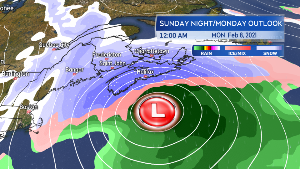
Snow develops for much of the Maritimes late Sunday afternoon through evening. Heavy bands of snow will wrap in off the Atlantic.
AMOUNTS
Widespread snowfall totals of 20 to 45 cm are expected for Nova Scotia.
PEI will see 10 to 30 cm with the highest amounts in the east of the province.
Areas near the Bay of Fundy coastline in New Brunswick extending into Moncton and the southeast can expect 10 to 20 cm. Moving north in New Brunswick, the snow amounts are expected to be lower. Still, Fredericton could see 5 cm to 10 cm.
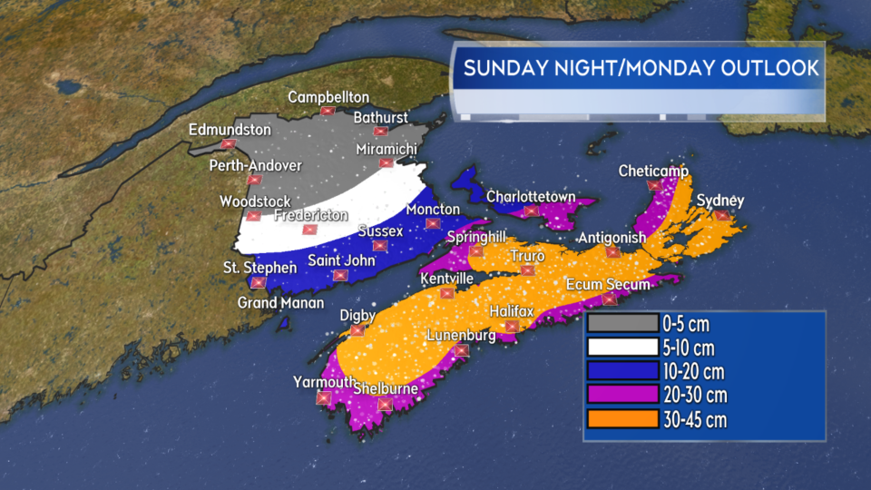
A widespread snow of 30 to 45 cm for Nova Scotia. 10 to 20 cm for parts of southern New Brunswick and Prince Edward Island. Eastern areas of Prince Edward Island could see 20 to 30 cm.
WINDS
Winds will be northeast Sunday evening and throughout the night, shifting northwest Monday morning.
Peak gusts will range from 60 km/h to 100 km/h for Nova Scotia, with the highest wind gusts most likely on the Atlantic coastline.
Peak gusts will range from 30 km/h to 50 km/h for New Brunswick, except for areas near the Bay of Fundy coastline, Moncton and the southeast regions, which will see 50 km/h to 70 km/h.
Peak gusts for Prince Edward Island will range from 60 km/h to 80 km/h, with the highest likely for coastal areas of Kings County.
Given the heavy snow accompanying the winds, I expect prolonged periods of whiteout conditions for those areas seeing snow in excess of 10 cm. I recommend avoiding travel during the weather event if possible. Gusty winds on Monday may continue to produce areas of drifting snow, particularly where roads run along open terrain such as fields.
There is a risk of power outages, particularly for Nova Scotia.

High and gusty winds will accompany the heavy snow creating extensive blowing snow and drifts. There is a risk of power outages particularly in Nova Scotia where the strongest gusts are expected.
MARINE
Storm to hurricane force winds will accompany the passage of the storm for many of the marine districts. The strongest of those winds will approach 65 knots overnight for the outermost Atlantic marine areas.
Seas of 4 to 8 metres are likely to accompany and follow the storm's passage on Sunday night through to Monday morning for the Atlantic marine areas. It is possible that seas could reach over 8 to 10 metres for the eastern Scotian Slope and Laurentian Fan on Monday morning.
Anyone operating on the ocean should consult a more detailed marine forecast.

Storm to hurricane-force winds are expected for many of the marine districts as the storm moves through. High seas will build for Atlantic marine areas.
Environment Canada has issued a series of weather warnings. Nova Scotia is under a Winter Storm Warning. Snowfall Warnings are in effect for Queens/Kings Counties PEI and for parts of southern New Brunswick.
Have your shovels and snowblowers ready for Monday, plan for delays, and give yourself lots of time if you need to commute.
I'll have updates on our televised news program, CTV Atlantic News at 7 PM on CTV Two.


