Forecaster warns Lee's winds could be 'faster' than expected on arrival in Maritimes
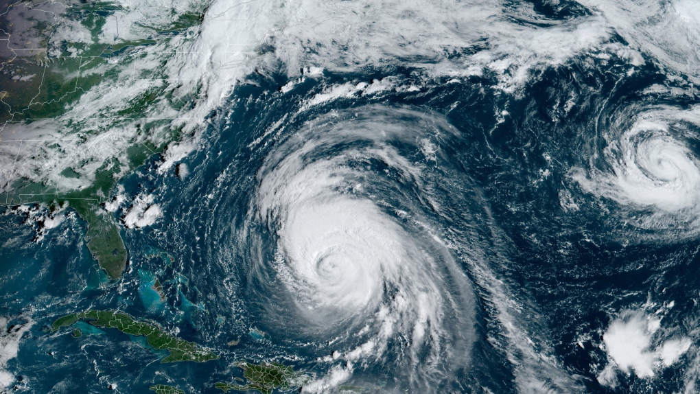
 This satellite image provided by CSU/CIRA-NOAA shows hurricane Lee in the Atlantic Ocean on Wednesday, September 13, 2023. (Source: THE CANADIAN PRESS/HO-CSU/CIRA-NOAA)
Hurricane Lee is now threatening to make an earlier and windier landing in the Maritimes after picking up speed on its approach to land, forecasters say.
Chris Fogarty with the Canadian Hurricane Centre said in a Wednesday morning forecast that the storm may feature a "somewhat faster approach speed" as it passes Cape Cod and arrives in the region. That would increase the wind threat over western Nova Scotia and southern New Brunswick, Fogarty wrote.
"As of now, western Nova Scotia has the highest possibility of impacts," he wrote, adding that the region has not been hit as severely as other parts of the province during recent storms such as Dorian and Fiona.
In an updated statement Wednesday afternoon, the centre described the arrival of Lee as "a Saturday event for the strongest impacts, with lingering, weaker conditions on Sunday."
In an interview, Bob Robichaud, a meteorologist at the centre, said if the storm comes up from the mid-Atlantic more rapidly than originally expected, "the storm will not necessarily weaken as fast, and it's still within the range of wind speeds between 100 and 120 km/h by the time it reaches the Gulf of Maine area."
However, the eventual track of the storm remains uncertain, and the centre says it could make landfall anywhere from the coast of Maine to western Nova Scotia.
He said that one factor that could affect the forecast is the manner in which an area of low pressure interacts with the storm as it approaches.
As of 4 p.m. local time, the storm was in the northern Caribbean, ranked as a Category 3 hurricane and located about 675 kilometres south-southwest of Bermuda. It was moving at 25 km/h.
Lee is forecast to keep travelling north and lose strength in cooler waters before potentially making landfall in Canada as a tropical storm, and becoming a post-tropical storm.
Still, Atlantic Canadians are now well aware that a post-tropical storm -- which tends to have a wider shape and less intensity than a hurricane -- may nonetheless pack a powerful punch, with winds close to hurricane force and the capacity to deliver 50 to 100 millimetres of rain in a few hours, said Robichaud.
Robichaud said it's still too early to give precise predictions on the potential tidal surges along the Bay of Fundy, but he said it isn't currently expected to produce major rises in coastal sea levels. In addition, the storm is arriving during a week of lower tides in the bay.
"It's not going to be something like we saw last year with (post-tropical storm) Fiona," he added.
The hurricane centre is also calling for rainfall on Thursday and Friday across the Maritimes in the prelude to Lee's arrival, with amounts varying from 20 to 40 millimetres.
Robichaud said the storm's heaviest rain typically falls on the left side of the storm's track -- which he said in Lee's case would likely be in western New Brunswick and northward into eastern Quebec.
This report by The Canadian Press was first published Sept. 13, 2023.
CTVNews.ca Top Stories

BREAKING Real GDP per capita declines for 6th consecutive quarter, household savings rise
Statistics Canada says the economy grew at an annualized pace of one per cent during the third quarter, in line with economists' expectations.
W5 Investigates A 'ticking time bomb': Inside Syria's toughest prison holding accused high-ranking ISIS members
In the last of a three-part investigation, W5's Avery Haines was given rare access to a Syrian prison, where thousands of accused high-ranking ISIS members are being held.
Class-action lawsuit on 'opioid-related wrongs': Court to rule on drug companies' appeal
Canada's top court will rule Friday on the appeal of a class-action lawsuit meant to recoup some of the costs associated with British Columbia's opioid crisis from major drug makers and distributors.
As Australia bans social media for children, Quebec is paying close attention
As Australia moves to ban social media for children under 16, Quebec is debating whether to follow suit.
Irregular sleep patterns may raise risk of heart attack and stroke, study suggests
Sleeping and waking up at different times is associated with an increased risk of heart attack and stroke, even for people who get the recommended amount of sleep, according to new research.
California man who went missing for 25 years found after sister sees his picture in the news
It’s a Thanksgiving miracle for one California family after a man who went missing in 1999 was found 25 years later when his sister saw a photo of him in an online article, authorities said.
Trudeau Liberals' two-month GST holiday bill passes the House, off to the Senate
The federal government's five-page piece of legislation to enact Prime Minister Justin Trudeau's promised two-month tax break on a range of consumer goods over the holidays passed in the House of Commons late Thursday.
Nick Cannon says he's seeking help for narcissistic personality disorder
Nick Cannon has spoken out about his recent diagnosis of narcissistic personality disorder, saying 'I need help.'
Notre Dame Cathedral: Sneak peek ahead of the reopening
After more than five years of frenetic reconstruction work, Notre Dame Cathedral showed its new self to the world Friday, with rebuilt soaring ceilings and creamy good-as-new stonework erasing somber memories of its devastating fire in 2019.


