Friday snow piles up to more than 20 centimetres in parts of the Maritimes
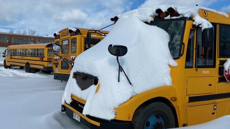
 Snow falling and adding up in Black River, N.S. (Courtesy: Holly Hopgood-Chappus)
The Friday snowfall has ended up being higher than expected by several centimetres in parts of the Maritimes.
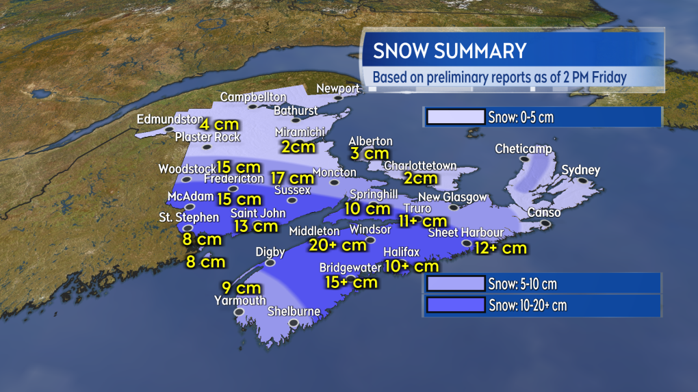
It looks like the system will finish with a broad swath of snow totals 10 to 20 centimetres across a large area of southern New Brunswick and the western half of mainland Nova Scotia.
There are some preliminary reports that parts of the Annapolis Valley and east towards the Enfield area picked up some amounts in the range of 20 to 30 centimetres. New Brunswick has finished with the accumulating snow and the remaining snow in Nova Scotia will ease to flurries by late Friday afternoon or early Friday evening.
 A rough summary of the snow into early Friday afternoon. Unofficial and based on preliminary reports.
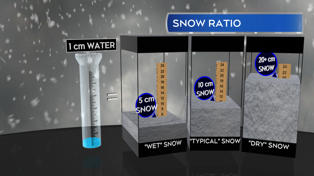
There was some incredible powder with this system and that fluffier snow allowed it to really add up, despite having relatively modest levels of moisture to work with. For example, the 15 centimetres of snow reported in Fredericton melted down to just 5 millimetres of water. That’s a near 30:1 snow to water ratio! A typical snow ratio is about 10:1, so the usual expectation out of 5 millimetres of water would be 5 centimetres of snow. Colder air in place favours a higher snow ratio and that certainly played out Friday in the region. On the plus side, the powdery snow should be relatively light by weight to clear out of the way.
While the snow is ending, some caution is warranted if travelling the roads Friday evening and into the overnight hours. The fluffy snow is more likely to blow around by the blustery north wind we will be left with. Areas of drifting and blowing snow are possible, especially where roads are present by open terrain, such as fields.
 The dry or “fluffy” nature of this snow has resulted in some very high snow to liquid ratios -- 15 centimetres of snow in Fredericton melting to just 5 millimetres of water.
You will want to clear the freshly fallen snow as there’s no big warm-up to melt it away.
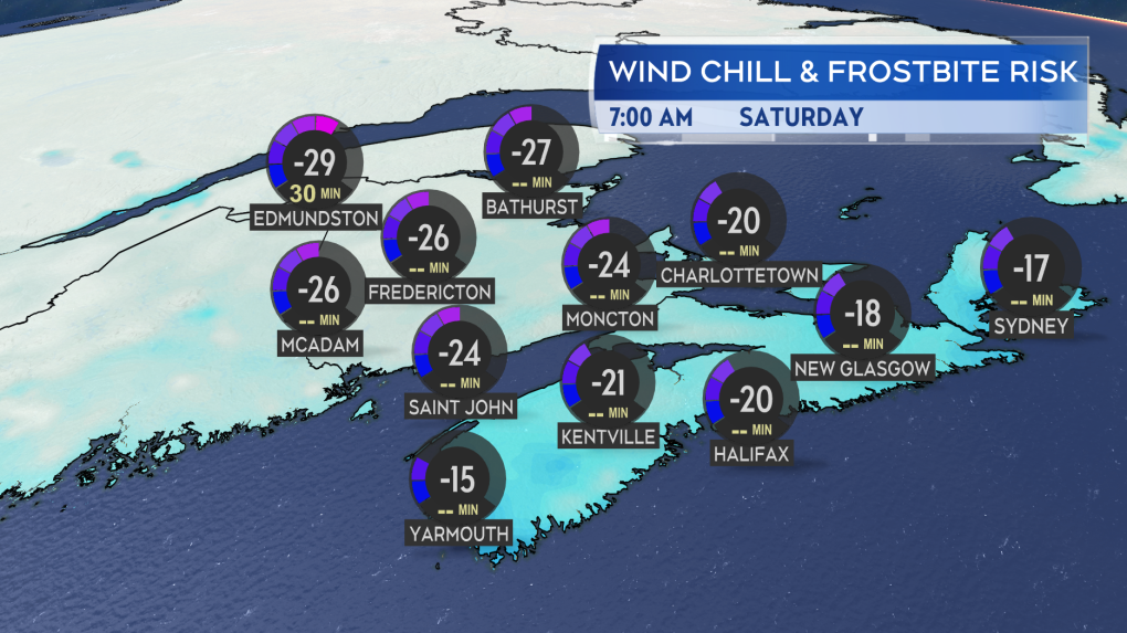
In fact, temperatures are going to remain cold -- below average even for late February -- this weekend and well into next week. The cold air is forecast to moderate towards the end of next week, which, of course, will be the start of March.
 Bitterly cold air in place for the start of the weekend. Colder weather persists into next week.
CTVNews.ca Top Stories

W5 Investigates A 'ticking time bomb': Inside Syria's toughest prison holding accused high-ranking ISIS members
In the last of a three-part investigation, W5's Avery Haines was given rare access to a Syrian prison, where thousands of accused high-ranking ISIS members are being held.
'Mayday!': New details emerge after Boeing plane makes emergency landing at Mirabel airport
New details suggest that there were communication issues between the pilots of a charter flight and the control tower at Montreal's Mirabel airport when a Boeing 737 made an emergency landing on Wednesday.
Class-action lawsuit on 'opioid-related wrongs': Court to rule on drug companies' appeal
Canada's top court will rule Friday on the appeal of a class-action lawsuit meant to recoup some of the costs associated with British Columbia's opioid crisis from major drug makers and distributors.
Real GDP per capita declines for 6th consecutive quarter, household savings rise
Statistics Canada says the economy grew at an annualized pace of one per cent during the third quarter, in line with economists' expectations.
Irregular sleep patterns may raise risk of heart attack and stroke, study suggests
Sleeping and waking up at different times is associated with an increased risk of heart attack and stroke, even for people who get the recommended amount of sleep, according to new research.
Nick Cannon says he's seeking help for narcissistic personality disorder
Nick Cannon has spoken out about his recent diagnosis of narcissistic personality disorder, saying 'I need help.'
California man who went missing for 25 years found after sister sees his picture in the news
It’s a Thanksgiving miracle for one California family after a man who went missing in 1999 was found 25 years later when his sister saw a photo of him in an online article, authorities said.
As Australia bans social media for children, Quebec is paying close attention
As Australia moves to ban social media for children under 16, Quebec is debating whether to follow suit.
Trudeau Liberals' two-month GST holiday bill passes the House, off to the Senate
The federal government's five-page piece of legislation to enact Prime Minister Justin Trudeau's promised two-month tax break on a range of consumer goods over the holidays passed in the House of Commons late Thursday.


