Heavy rain continues to pour into the Maritimes heading into the Easter weekend
Anatomy of a soaker
A slow moving weather front continues to direct a stream of moisture up the eastern seaboard into the Maritimes. The lift (upward movement) in the atmosphere ahead of the front is causing the heavy moisture to rise and form into clouds and rain. The pattern persists into Saturday morning after which the final part of the system moves north over the Gulf of St. Lawrence.
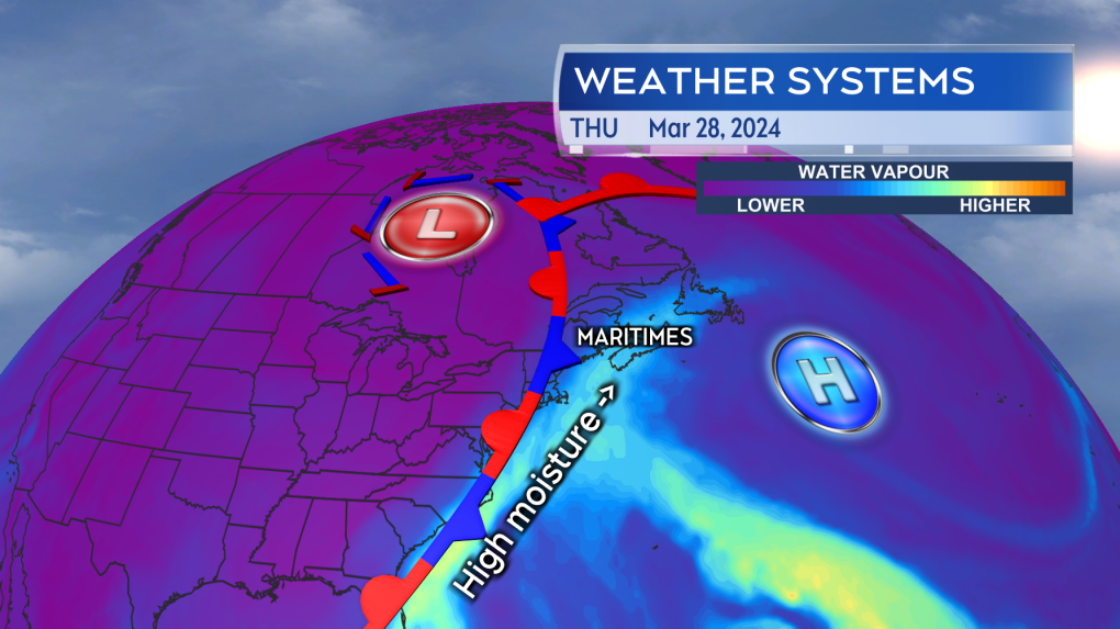 A slow moving weather front continues to move moisture up the eastern seaboard into the Maritimes like a conveyor belt.
Rain is widespread in the Maritimes Thursday night and Friday. There is also an increased risk of downpours within the rain during that period of time. Rain, except rain turning to wet snow for New Brunswick, continues into Friday night, with much of the remaining rain and snow mix will clear Saturday morning through early Saturday afternoon.
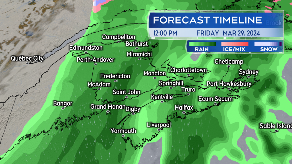 Rain and downpours continue through Thursday night and Friday.
Additional rain and weather warnings
There are already areas of New Brunswick and southwestern Nova Scotia that have received over 30 mm of rain with much more to come. The most additional rain is expected across southwestern Nova Scotia and into central and southern New Brunswick. Downpours may also produce pockets of higher rain totals in eastern Nova Scotia, including eastern Halifax County to Cape Breton County, and possibly western Prince Edward Island.
By Saturday morning, those areas will have likely picked up rain totals in excess of 60, 80, and even 100 mm. While adding up over a period of days, the prolonged and heavy rain increases the risks of localized flooding, culvert washouts, and hydroplaning on roads.
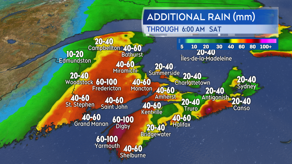 Additional rain amounts of more than 60 and even 80 mm are expected by early Saturday morning.
Rainfall warnings are in effect for all of New Brunswick with the exception of Madawaska County and western Restigouche County. Central and southern areas of New Brunswick are particularly at risk of seeing rain totals over 100 mm by Saturday morning. River Watch New Brunswick only had a few sites listed at an advisory level as of Thursday afternoon. Residents in the province who live near a waterway (rivers, streams, creeks, tributaries) need to be aware that water levels will rise as the rain continues through the end of this week.
Rainfall warnings are in effect for Shelburne, Yarmouth, Digby, and Annapolis Counties of Nova Scotia. The warnings call for additional rain up to or in excess of 80 mm through Friday night. The agency cautioning that “heavy downpours can cause flash floods and water pooling on roads” and that “localized flooding in low-lying areas is possible.”
Easter weekend outlook
Good Friday is a washout. Rain across the region with the risk of downpours. Not particularly cold with high temperatures ranging high single digits through mid-teens. Likewise wind won’t be a large issue, variable in direction with most gusts ranging from 20 to 40 km/h.
Saturday will see a mixture of rain and snow showers clear in the morning through afternoon. Wind becoming westerly and increasing in strength. Peak wind gusts for the Maritimes on Saturday are likely to range 40 to 70 km/h. Cooler, with high temperatures in the low-to-mid single digits for most.
Sunday is looking like the best of the three days. The most ideal for an Easter egg hunt. Wind will be northwest with gusts diminishing into a range of 20 to 40 km/h. A mix of sun and cloud with high temperatures again in the low-to-mid single digits.
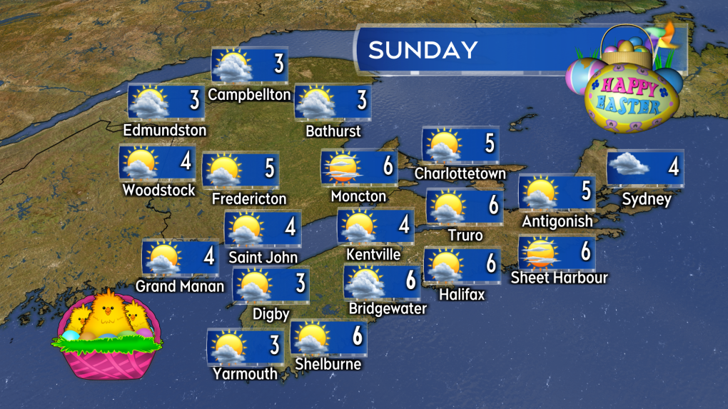 Easter Sunday is set to be the fairest weather day of the long weekend.


CTVNews.ca Top Stories

Here's where Canadians are living abroad: report
A recent report sheds light on Canadians living abroad--estimated at around four million people in 2016—and the public policies that impact them.
'We are declaring our readiness': No decision made yet as Poland declares it's ready to host nuclear weapons
Polish President Andrzej Duda says while no decision has been made around whether Poland will host nuclear weapons as part of an expansion of the NATO alliance’s nuclear sharing program, his country is willing and prepared to do so.
Harvey Weinstein hospitalized after return to New York from upstate prison
Harvey Weinstein’s lawyer said Saturday that the onetime movie mogul has been hospitalized for a battery of tests after his return to New York City following an appeals court ruling nullifying his 2020 rape conviction.
Deadly six-vehicle crash on Highway 400 sparked by road rage incident
One person was killed in a six-vehicle crash on Highway 400 in Innisfil Friday evening.
Invasive and toxic hammerhead worms make themselves at home in Ontario
Ontario is now home to an invasive and toxic worm species that can grow up to three feet long and can be dangerous to small animals and pets.
Central Alberta queer groups react to request from Red Deer-South to reinstate Jennifer Johnson to UCP caucus
A number of LGBQT+2s groups in Central Alberta are pushing back against a request from the Red Deer South UCP constituency to reinstate MLA Jennifer Johnson into the UCP caucus.
Opinion
Opinion I just don't get Taylor Swift
It's one thing to say you like Taylor Swift and her music, but don't blame CNN's AJ Willingham's when she says she just 'doesn't get' the global phenomenon.
Sophie Gregoire Trudeau on navigating post-political life, co-parenting and freedom
Sophie Gregoire Trudeau says there is 'still so much love' between her and Prime Minister Justin Trudeau, as they navigate their post-separation relationship co-parenting their three children.
First court appearance for boy and girl charged in death of Halifax 16-year-old
A girl and a boy, both 14 years old, made their first appearance today in a Halifax courtroom, where they each face a second-degree murder charge in the stabbing death of a 16-year-old high school student.
Shopping Trends
The Shopping Trends team is independent of the journalists at CTV News. We may earn a commission when you use our links to shop. Read about us.


Toronto
-

Murder charge laid after man falls to death from Toronto apartment balcony
One person has been charged with second-degree murder in connection with the death of a man who fell from a balcony following an altercation inside a Toronto apartment building.
-
Invasive and toxic hammerhead worms make themselves at home in Ontario
Ontario is now home to an invasive and toxic worm species that can grow up to three feet long and can be dangerous to small animals and pets.
-
Toronto Maple Leafs winger William Nylander on course to suit up in Game 4 against Bruins
William Nylander is poised to join the Stanley Cup chase.
Calgary
-

Beltline collision between SUV and motorbike sends driver ‘cartwheeling through the air’
A blue SUV and a motorbike collided Saturday afternoon in the Beltline.
-
Central Alberta queer groups react to request from Red Deer-South to reinstate Jennifer Johnson to UCP caucus
A number of LGBQT+2s groups in Central Alberta are pushing back against a request from the Red Deer South UCP constituency to reinstate MLA Jennifer Johnson into the UCP caucus.
-
Rain barrel sale sells out early, as demand surges amid fears of summer drought
Rain barrel sale season kicked off Saturday morning with a splash.
Edmonton
-

Kane makes impact with Gordie Howe hat trick, Oilers rout Kings to take series lead
Evander Kane’s teammates believe he’s tailor-made for the playoffs, and so does the man himself.
-
Inside Alberta's promising psychedelic-assisted therapy industry
The view from Cena Life’s new clinic in a South Edmonton high-rise looks out clear to the edge of the city. And in the row of treatment rooms that line the office space, you can see the optimism within the company that the psychedelic-assisted therapies offered have a strong future in mental health care in Alberta.
-
Central Alberta queer groups react to request from Red Deer-South to reinstate Jennifer Johnson to UCP caucus
A number of LGBQT+2s groups in Central Alberta are pushing back against a request from the Red Deer South UCP constituency to reinstate MLA Jennifer Johnson into the UCP caucus.
Montreal
-

'Divest now': Students launch encampment at McGill University
Several students have launched an encampment at McGill University as they call on the institution to cut financial ties with Israel.
-
Transit trips up among seniors since Montreal introduced free fare program, city says
Montreal says public transit trips were up between 15 and 20 per cent among people age 65 and over in the six months after it made the service free for local seniors.
-
Driver arrested after woman, 51, dies in head-on collision in Lachute
Quebec provincial police say a 51-year-old woman has died after a head-on collision in the town of Lachute, roughly 50 kilometres west of Montreal, early this morning.
Ottawa
-

Here's what you need to know about 'halal mortgages,' rates
The 2024 federal budget announced on April 16 included plans to introduce “halal mortgages” as a way to increase access to home ownership.
-
Ottawa woman, 47, facing charges following downtown hate crimes
The Ottawa Police Service says a 47-year-old woman is facing charges following a series of hate crimes in the downtown area last week.
-
No injuries reported following single-vehicle collision on Highway 15 in eastern Ontario
The Ontario Provincial Police (OPP) asked drivers to expect delays after a single-vehicle collision on Highway 15 near Brewers Mills Road Saturday morning.
London
-

Fatal crash victim identified as 24-year-old Western University graduate
A 24-year-old man who died Friday in a car crash on Highway 401 has been identified as Omar Barzak from London, Ont.
-
'Beneath all these colours we are all one': Thousands attend Hindu Holi Festival at Victoria Park
London’s Victoria Park was filled with colours Saturday afternoon as those attending Holi threw coloured water and powders into the air in a celebration of spring and unity.
-
'I felt disappointed': Local women’s advocates lament MP Karen Vecchio’s ouster as Status of Women Committee chair
At an event in which she was celebrated for her advocacy of women’s issues, Karen Vecchio was in no mood to speak about her removal from her role of chair of Federal Parliament’s Status of Women Committee.
Barrie
-
Deadly six-vehicle crash on Highway 400 sparked by road rage incident
One person was killed in a six-vehicle crash on Highway 400 in Innisfil Friday evening.
-
Caledon OPP investigating serious two-vehicle crash
Police in Caledon are investigating a crash that left one person with life-altering injuries.
-
All things maple syrup celebrated at annual Elmvale festival
Despite the poor weather, a festival celebrating all things maple syrup drew thousands of people to Elmvale on Saturday.
Northern Ontario
-
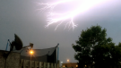
Severe thunderstorm watch in effect for Sudbury, West Nipissing
Environment Canada issued a severe thunderstorm watch for several communities in northeastern Ontario on Saturday afternoon – primarily the Greater Sudbury area and West Nipissing.
-
Deadly six-vehicle crash on Highway 400 sparked by road rage incident
One person was killed in a six-vehicle crash on Highway 400 in Innisfil Friday evening.
-
French River area preparing for more flooding with weekend rain expected
The Municipality of French River has been under a flood watch since Thursday evening and many residents told CTV News that they fear the already high water levels combined with the rain forecasted in the coming days may cause more widespread flooding.
Kitchener
-

Kitchener family says their 10-year-old needs life-saving drug that cost $600,000
Raneem, 10, lives with a neurological condition and liver disease and needs Cholbam, a medication, for a longer and healthier life.
-
Pedestrian seriously hurt following hit-and-run crash in Cambridge, driver arrested
A driver has been arrested and a pedestrian has been seriously injured following a hit-and-run crash in Cambridge.
-
Cambridge Moves for Mental Health draws dozens in spite of weather
Rainy weather for the second year in a row once again did not deter attendees from a special fundraising event.
Windsor
-
 VIDEO
VIDEOVIDEO From Windsor high school grad to New York Giant: Theo Johnson selected in NFL Draft
A former graduate of Holy Names High School will soon be moving to New York after being selected during the NFL Draft in Detroit on Saturday.
-
'It’s just life changing': No need to sell home after Windsorite wins 100K
Playing bingo in April made a local resident $100,000 richer -- and will keep him in his home.
-
Alleged hate crimes reported at University of Windsor campus
Campus police are investigating after homophobic slurs were carved into the door of the University of Windsor’s Campus Pride Centre earlier this month.
Winnipeg
-

A timeline of the Jeremy Skibicki case
The trial for the man accused of killing four Indigenous women in Winnipeg is set to get underway on April 29.
-
Winnipeg emergency crews battle 5 fires in 6 hours Saturday morning
Winnipeg Fire Paramedic Service crews were busy Saturday morning, responding to five different structure fires within several hours.
-
Ice pileup warnings for Lake Manitoba and Lake Winnipeg this weekend
With heavy wind gusts expected along Lake Manitoba and Lake Winnipeg this weekend, the provincial government is warning residents and property owners about potential ice pileups.
Regina
-

First annual 'Crocus Walk' takes place in Regina
The first annual Crocus Walk took place on Friday afternoon along Wascana Creek near the Callie Curling Club.
-
Teen boy charged after stealing from Regina business
A teen boy is facing several charges after he stole items from a business on Friday in Regina.
-
Regina fire crews respond to late night blaze
Regina fire crews responded to a late night blaze on Friday night at a house on the 1900 block of St. John Street.
Saskatoon
-

Saskatoon care home workers escalating strike action
Workers at group homes run by LutherCare Communities in Saskatoon are escalating their strike action.
-
Saskatoon police investigating after body found at recycling facility
The Saskatoon Police Service (SPS) and Saskatchewan Coroners Service are investigating after a woman’s body was found at a recycling facility Friday morning.
-
Hometown kid nets overtime winner, Warriors lead 1-0
Brayden Yager was the hometown hero, albeit for the visiting team in game one of the WHL Eastern Conference Final.
Vancouver
-

Offensive lineman Giovanni Manu selected by Detroit Lions, becomes 1st UBC player ever taken in NFL draft
Canadian football observers thought it could happen, and on Saturday, it did. Towering offensive lineman Giovanni Manu – who was born in Tonga and grew up in Pitt Meadows, B.C. – became the first player from the University of British Columbia ever to be selected in the NFL draft.
-
Woman found dead inside Surrey home, homicide investigators called in
A large police presence in Surrey's East Newton neighbourhood Friday night is now a homicide investigation, local Mounties said Saturday.
-
Conservation officers give warning after coyote bites woman, dog near Vancouver park
Conservation officers are reminding the public to keep their pets on a leash after a coyote attacked a woman and her dog near a park in South Vancouver.
Vancouver Island
-

Canucks defeat Predators in Game 3, take 2-1 series lead
J.T. Miller had a goal and assist and the Vancouver Canucks edged the Nashville Predators 2-1 to re-take the lead in their first-round playoff series.
-
Haida Elder suing Catholic Church and priest, hopes for 'healing and reconciliation'
The lawyer for a residential school survivor leading a proposed class-action defamation lawsuit against the Catholic Church over residential schools says the court action is a last resort.
-
Cisco reveals security breach, warns of state-sponsored spy campaign
State-sponsored actors targeted security devices used by governments around the world, according to technology firm Cisco Systems, which said the network devices are coveted intrusion points by spies.
Kelowna
-

B.C. man rescues starving dachshund trapped in carrier: BC SPCA
An emaciated dachshund is now recovering thanks to a Good Samaritan who found the pup near a biking trail in Kelowna, according to the BC SPCA.
-
Search crews called in after missing Kelowna senior's truck found
Search and rescue crews have been called in after a vehicle belonging to a missing senior was located near a rural intersection outside of Kelowna Tuesday.
-
Homicide investigation underway after body found near Kelowna, B.C.
Major crime detectives in British Columbia are investigating a suspected homicide after a body was found in a remote area southeast Kelowna over the weekend.


