Hurricane watches issued ahead of weekend arrival of Fiona
A series of hurricane and tropical storm watches were issued for Atlantic Canada by Environment Canada and the Canadian Hurricane Centre Thursday afternoon. A watch means that hurricane or tropical storm conditions are possible in the alerted area within 36 hours.
TRACK
Hurricane Fiona continues to pick up speed towards the north as a Category 4 hurricane, now moving at nearly 25 kilometres per hour. The storm is forecast to pass to the west of Bermuda and enter the Scotian Slope marine waters of Atlantic Canada as a Category 3 hurricane on Friday.
Landfall as a powerful post-tropical storm, equivalent to a Category 1 or 2 hurricane looks increasingly likely in eastern Nova Scotia Saturday morning. The forecast cone for that landfall has now narrowed to span eastern Halifax County across Cape Breton. Various computer models show a landfall somewhere in the area from Canso to near Louisbourg in Nova Scotia between 6 a.m. and 10 a.m. Saturday. Weather conditions in the Maritimes will deteriorate Friday night into Saturday morning.
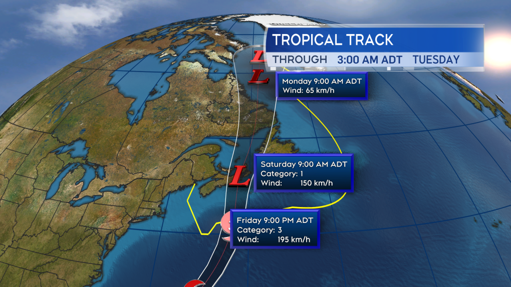 Fiona is expected to enter Canadian waters as a Category 3 hurricane late Friday. Becoming a power post-tropical storm as it makes landfall in eastern Nova Scotia Saturday morning.
HURRICANE WATCH ISSUED
A hurricane watch has been posted for Prince Edward Island and Halifax -- east across Nova Scotia. Tropical storm watches extend into the southwest of Nova Scotia and eastern New Brunswick.
The highest probabilities of hurricane force winds -- a one-minute sustained wind of 119 kilometres per hour or more -- are near and to the east of the expected landfall point. At this time, that includes parts of Guysborough and Antigonish counties on the mainland of Nova Scotia, as well as Cape Breton. Tropical storm force winds -- a one-minute sustained wind of 63 kilometres per hour -- are being given a high probability across P.E.I. and Halifax – in eastern Nova Scotia.
A moderate probability of a tropical storm force wind extends into the south shore of Nova Scotia and southeastern New Brunswick. Gust strength will exceed those one-minute sustained winds.
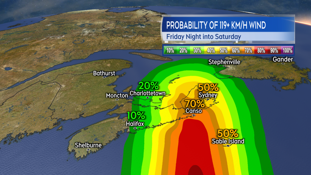 The highest probability of a hurricane force wind will be near and to the east of the landfall point. Currently looking most likely to be in eastern Nova Scotia.
 The risk of tropical storm force winds extends across much of Nova Scotia, Prince Edward Island, and into southeastern New Brunswick. That is a one minute sustained wind near 63 km/h with gusts possibly reach 100 km/h or higher.
WIND
Wind will increase in strength for much of the Maritimes Friday night into Saturday morning.
Peak gusts in eastern Nova Scotia and P.E.I. could reach 120 to 150 kilometres per hour due to being in proximity to the centre of the storm as it passes. That said, widespread gusts reaching 90 to 120 kilomtres per hours look possible, extending as far west as Halifax in Nova Scotia.
Gusts reaching 70 to 90 kilometres per hour could possibly extend into the southwest of Nova Scotia and eastern New Brunswick. Wind direction will primarily be out of the north and northwest. The exception is the area east of the landfall point, most likely Cape Breton, where the direction will be easterly turning southerly.
Wind of that strength will have the potential to cause power outages. In the eastern part of the region, where the wind is forecast to be strongest, there is an increased risk of tree and branch falls. Where the wind is onshore, it will help to produce a ferocious surf and risk of storm surge.
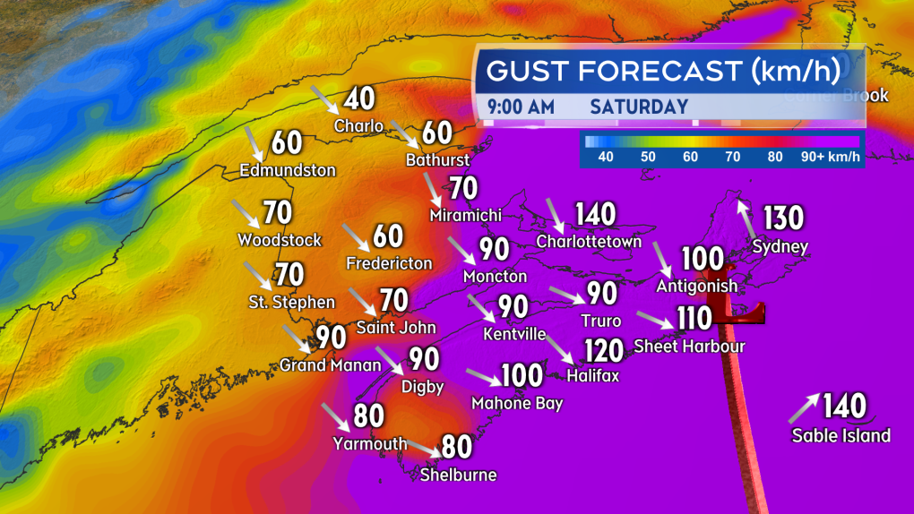 The strongest wind gusts look increasingly likely for eastern Nova Scotia and Prince Edward Island.
STORM SURGE
The greatest risk of a damaging storm surge looks to be the eastern and northern coastlines of Nova Scotia, the southeastern coastline of New Brunswick, and the northern coastline of P.E.I. The very low barometric pressure in the centre of the storm will allow for ocean water to rise up under it.
Intense winds will increase wave action against the coast further increasing the risk of flooding or damage. Near coastal waves reaching 10 metres, or 30 feet, may be present on the eastern shore of Nova Scotia late Friday night into Saturday morning.
A significant build of wave height in the Gulf of St. Lawrence is also expected, increasing the risk of erosion on north facing beaches of P.E.I. There is a period of high tide for the eastern part of the Maritimes Saturday morning -- particular caution should be taken during that tide. Waves and risk of storm surge should diminish moving through Saturday afternoon into Saturday evening.
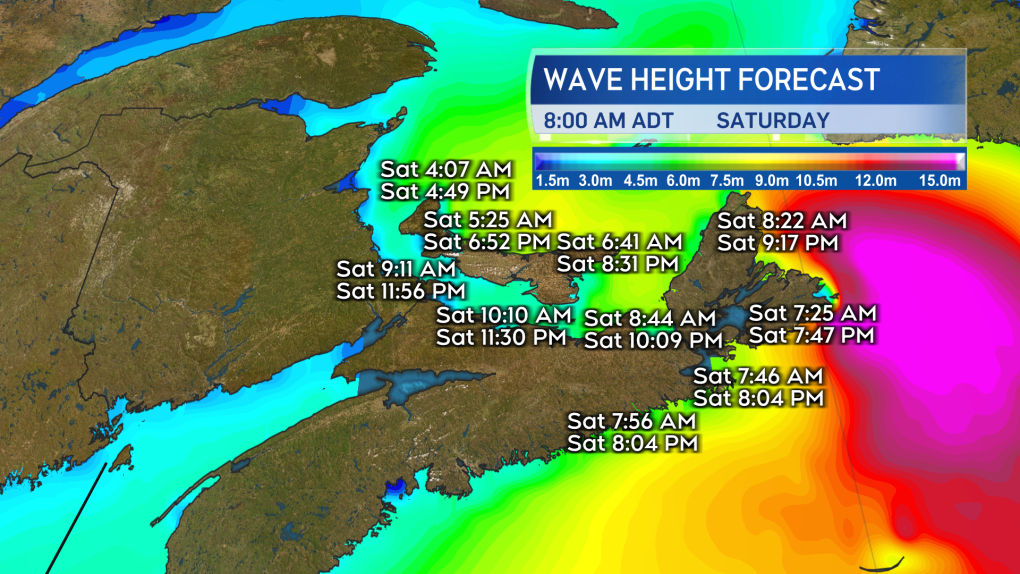 The risk of a damaging storm surge is highest in the east of the Maritimes. Extra caution should be taken if by the coast in that area particularly during the high tide Saturday morning.
RAINFALL
Torrential rain is expected for eastern parts of the Maritimes Friday night into Saturday morning. Friday through Saturday could see rain totals of 80 to 200 millimetres in eastern P.E.I. and eastern Nova Scotia increasing the risk of flash flooding and washouts. Rainfall totals could reach 50 to 80 millimetres extending towards the west of P.E.I. and central areas of Nova Scotia. There is potential for heavy rainfalls to quickly move into New Brunswick and the southwest of Nova Scotia.
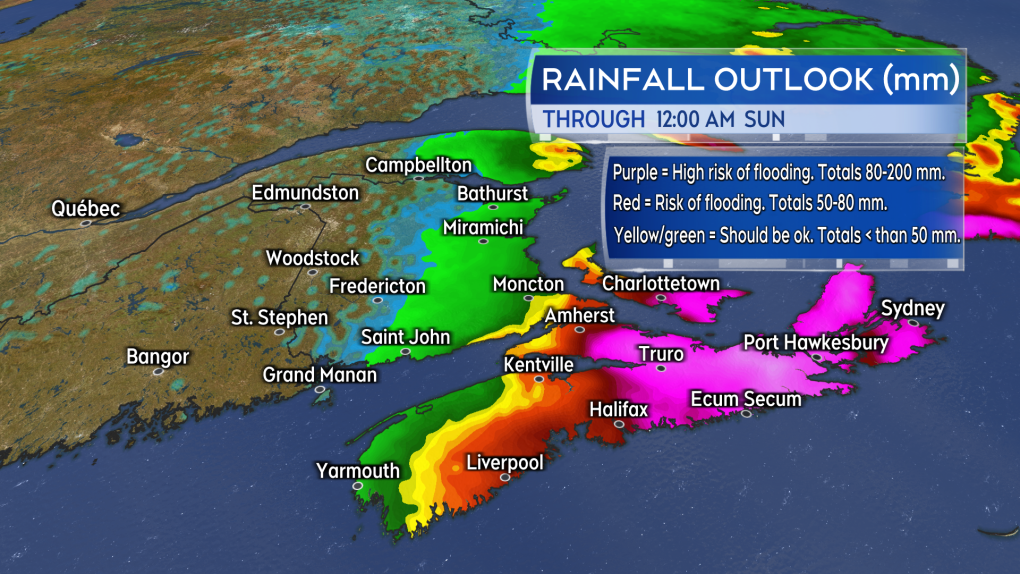 The risk of flooding is expected to be highest in eastern Prince Edward Island and eastern Nova Scotia. Rain in that part of the Maritimes could total 80 to 200 mm Friday through Saturday.
PREPARATIONS
Maritimers who have them should make sure that sump pumps and generators are in working order and the drainage on their property is clear of debris.
Other storm preparations to take include:
- having batteries for use in flashlights and lamps
- making sure mobile devices are charged
- stocking up on food and medication to last a period of 72 hours
- not travelling during the passage of the storm and the worst of the inclement weather
CTVNews.ca Top Stories

W5 Investigates A 'ticking time bomb': Inside Syria's toughest prison holding accused high-ranking ISIS members
In the last of a three-part investigation, W5's Avery Haines was given rare access to a Syrian prison, where thousands of accused high-ranking ISIS members are being held.
Trudeau Liberals' two-month GST holiday bill passes the House, off to the Senate
The federal government's five-page piece of legislation to enact Prime Minister Justin Trudeau's promised two-month tax break on a range of consumer goods over the holidays passed in the House of Commons late Thursday.
Irregular sleep patterns may raise risk of heart attack and stroke, study suggests
Sleeping and waking up at different times is associated with an increased risk of heart attack and stroke, even for people who get the recommended amount of sleep, according to new research.
California man who went missing for 25 years found after sister sees his picture in the news
It’s a Thanksgiving miracle for one California family after a man who went missing in 1999 was found 25 years later when his sister saw a photo of him in an online article, authorities said.
As Australia bans social media for children, Quebec is paying close attention
As Australia moves to ban social media for children under 16, Quebec is debating whether to follow suit.
Notre Dame Cathedral: Sneak peak ahead of the reopening
After more than five years of frenetic reconstruction work, Notre Dame Cathedral showed its new self to the world Friday, with rebuilt soaring ceilings and creamy good-as-new stonework erasing somber memories of its devastating fire in 2019.
Canada Post temporarily laying off striking workers, union says
The union representing Canada Post workers says the Crown corporation has been laying off striking employees as the labour action by more than 55,000 workers approaches the two-week mark.
Can't resist Black Friday weekend deals? How to shop while staying within your budget
A budgeting expert says there are a number of ways shoppers can avoid getting enveloped by the sales frenzy and resist spending beyond their means.
Montreal shopping mall playing 'Baby Shark' song to prevent unhoused from loitering
A shopping mall and office complex in downtown Montreal is being criticized for using the popular children's song 'Baby Shark' to discourage unhoused people from loitering in its emergency exit stairwells.


