Kalin’s Call: Expect rain and showers ahead of weekend heat
 A child holds an umbrella on a rainy day. (CTV News)
Parts of the Maritimes are in for a round of soggy weather to close the week, as a front and low pressure system move in from the south.
Rain and showers will arrive off the Atlantic and fill in across Nova Scotia Thursday evening and night. By late night, some shower activity will reach southern New Brunswick and Prince Edward Island. There is a risk of embedded thunderstorms within the rain for Nova Scotia.
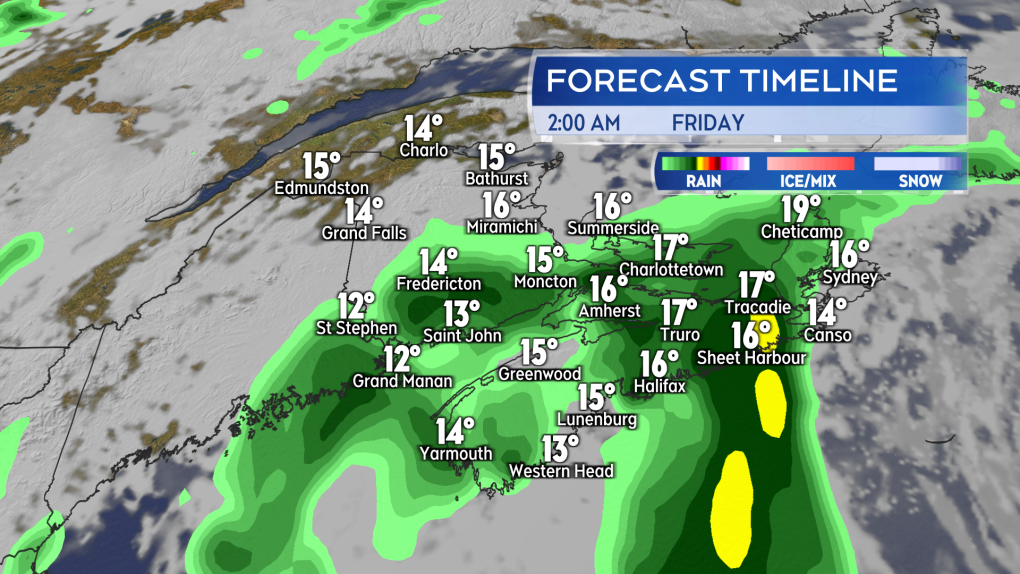 Rain, showers, and fog develop Thursday night. A risk of thunderstorms for Nova Scotia.
There will be periods of rain for both Nova Scotia and Prince Edward Island on Friday. Moncton and the southeast of New Brunswick could also see some of the steadier wet weather. Scattered showers are expected through the day for the remainder of New Brunswick.
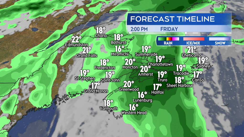 Further periods of rain for Nova Scotia and Prince Edward Island on Friday. Scattered showers for New Brunswick.
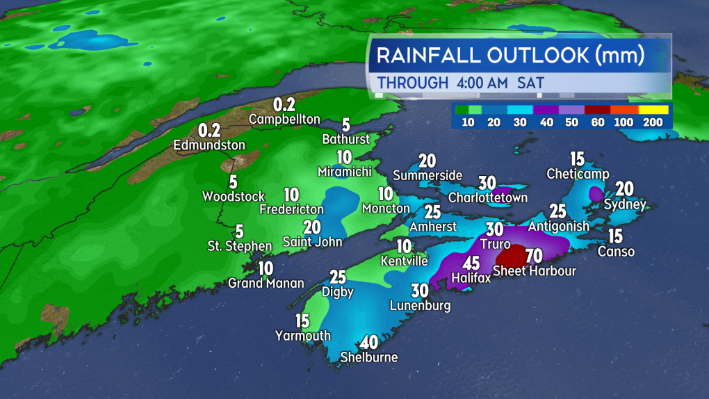
The heaviest rain looks like it will be centred on eastern mainland Nova Scotia. Eastern Halifax County and Guysborough County look likely to pick up a widespread 30 to 60 mm of rain. Cape Breton and the remainder of the Atlantic coast of Nova Scotia will see local totals of 20 to 40 mm in the event of a downpour or thunderstorm. A Special Weather Statement regarding the potential for heavier rain has been issued by Environment Canada for eastern mainland Nova Scotia and Cape Breton. With the risk of downpours and thunderstorms for Nova Scotia, rainfall rates could be high. Visibility may be reduced at times and hydroplaning conditions present on roads.
Prince Edward Island can expect rain totals of 10 to 30 mm, with lower amounts up west and higher down east. Rainfall should generally total 10 mm or less for New Brunswick.
The bulk of the rain and showers will end by late Friday night, followed by some weekend heat.
 The heaviest rain looks like it will be centred on eastern mainland Nova Scotia. Environment Canada has issued a Special Weather Statement regarding the potential for heavy rain for the east of that province.
A plume of hotter air looks set to build out of the northeastern U.S. and into the Maritimes this weekend. High temperatures on Saturday should reach the low-to-mid 20s for most, with some high 20s for New Brunswick. There is a chance of a shower or thunderstorm Saturday afternoon into evening. The area most likely to see some pop-up showers or thunderstorms includes southern New Brunswick, Prince Edward Island, as well as northern and eastern Nova Scotia.
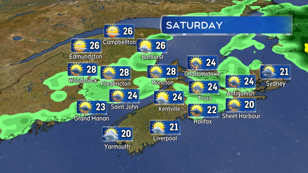 Warm to hot high temperatures are forecast for Saturday. A low risk of spotty showers and thunderstorms popping up afternoon into evening.
Mid-to-high 20s will be fairly widespread on Sunday, except cooler for areas directly on the coast. There will be an increase in humidity with this weekend’s temperatures, so expect it to feel more muggy as well.
For those who find the heat and humidity difficult to deal with, temperatures are expected cool with a round of showers moving through late Monday into Tuesday.
Shopping Trends
The Shopping Trends team is independent of the journalists at CTV News. We may earn a commission when you use our links to shop. Read about us.


CTVNews.ca Top Stories

W5 Investigates
W5 Investigates 'I never took part in beheadings': Canadian ISIS sniper has warning about future of terror group
An admitted Canadian ISIS sniper held in one of northeast Syria’s highest-security prisons has issued a stark warning about the potential resurgence of the terror group.
Trudeau talks border, trade in surprise dinner with Trump at Mar-a-Lago
Prime Minister Justin Trudeau discussed border security and trade during a surprise dinner with U.S.-president elect Donald Trump at Mar-a-Lago in West Palm Beach, Fla. on Friday evening, according to senior government sources.
Are scented candles bad for you? What the science says
Concerns about the safety of candles are rooted in the chemical reactions that occur when you burn them, as well as in the artificial fragrances and colorants that contribute to the various scents you may love.
Magic can't save 'Harry Potter' star Rupert Grint from a US$2.3 million tax bill
Former 'Harry Potter' film actor Rupert Grint faces a 1.8 million-pound (US$2.3 million) bill after he lost a legal battle with the tax authorities.
Postal workers union files unfair labour practice complaint over Canada Post layoffs
The union representing Canada Post workers has filed an unfair labour practice complaint with the Canada Industrial Relations Board over the layoffs of striking employees.
'Absolutely been a success': Responders looks back at 988, Canada's Suicide Crisis Helpline, one year later
In its first year, responders for Canada's Suicide Crisis Helpline, known as 988, have answered more than 300,000 calls and texts in communities nationwide.
Indonesian fishermen rescue 116 Rohingya refugees
Indonesian fishermen on Saturday rescued 116 Rohingya refugees, mostly hungry and weak women and children, after their rickety boat sank, officials said.
From inside a Cameroon jail, gay youth say police exploit homophobia to seek bribes
Cameroon's penal code criminalizes 'sexual relations with a person of the same sex,' with a maximum sentence of five years in prison and a $450 fine.
Face facts: Statues of stars like Kane and Ronaldo don't always deliver. Sculptors offer advice
One art critic compared the new Harry Kane bronze statue to a bulging-jawed comic strip character.
Toronto
-

Why this Toronto man ran so a giant stickman could dance
Colleagues would ask Duncan McCabe if he was training for a marathon, but, really, the 32-year-old accountant was committing multiple hours of his week, for 10 months, to stylistically run on the same few streets in Toronto's west end with absolutely no race in mind. It was all for the sake of creating a seconds-long animation of a dancing stickman for Strava.
-
'A huge, huge hit:' Ontario would be disproportionately impacted by Trump’s proposed tariffs, expert says
If U.S. President-elect Donald Trump follows through on a threat to impose a 25 per cent tariff on all Canadian imports, Ontario will likely see the brunt of the impact, a business professor at Carleton University says.
-
BREAKING
BREAKING Feds announce $758 million in funding for new Line 2 TTC subway trains
The TTC will get funding from the federal government to replace aging trains on Line 2, Deputy Prime Minister Chrystia Freeland has announced.
Calgary
-

Man who died trying to help stranded motorist identified as Khalid Farooq, father of 5
The man who lost his life trying to help a stranded motorist Wednesday has been identified as Khalid Farooq.
-
Cautious optimism? Alberta energy sector prepping for a turbulent 2025
Energy sector leaders say they're happy with how 2024 went but fear the stretch of good fortune could end in 2025.
-
3 injured in southeast Calgary stabbing; 1 in potentially life-threatening condition
Three people were injured in a stabbing incident in southeast Calgary on Friday. It happened in the 100 block of Walden Square S.E. at 4:40 p.m.
Edmonton
-

Massage therapist charged in connection with sexual assault at Mill Woods clinic
An Edmonton massage therapist has been charged with sexual assault in connection with an incident earlier this year.
-
Lights, markets and parades: Here's what's happening in and around Edmonton this weekend
The holiday magic never stops in Edmonton and the city, and surrounding communities, has plenty happening to keep people busy this weekend.
-
Armed convenience store robber sought by Edmonton police
Police are searching for the man who robbed a convenience store in southwest Edmonton last weekend.
Montreal
-

Buying a home? Here's everything you need to know about Quebec's 'welcome' tax
Anyone who has bought a home in Quebec knows the rollercoaster high of making that big, life-changing purchase – and the sudden crash that occurs when the welcome tax bill comes in the mail, alongside its 30-day payment deadline.
-
Montreal researchers make breakthrough discovery in fighting HIV
Researchers in Montreal have made a breakthrough discovery in HIV research by finding a way to expel the virus from its hiding places and destroy it.
-
Hit man offered $100,000 to kill Montreal crime reporter covering his trial
Political leaders and press freedom groups on Friday were left shell-shocked after Montreal news outlet La Presse revealed that a hit man had offered $100,000 to have one of its crime reporters assassinated.
Ottawa
-
 NEW THIS MORNING
NEW THIS MORNING Canadian Army vehicles on roads and highways in the Ottawa area starting this weekend
Attention eastern Ontario drivers! You may see an increased number of Canadian Army vehicles on roads and highways in the Ottawa area starting this weekend, warns the Ontario Provincial Police (OPP).
-
'We will always be a downtown store': Steve's Music Store moving from Rideau Street after 42 years
A staple of the Rideau Street corridor, Steve's Music Store, is packing up and moving out after 42 years in business. The store will not be closing, its manager says, but rather moving to a new location that is yet unannounced.
-
Flurries in the forecast for Ottawa this Saturday
Flurries are in the forecast for Ottawa this Saturday.
London
-

City and Byron property owner approach agreement after years of disputes
A settlement appears to be in the works between the city and a property owner in Byron who leveled a historic barn.
-
CTV News London’s top stories from this week
In case you missed it, CTV News London has gathered all of the top local stories from this week into one video for your convenience.
-
Parts of region bracing for up to one metre of snow this weekend
It’s a day for digging in Bruce County. School buses across Bruce and Grey counties were cancelled Friday due to snowsqualls that dumped as much as 15 centimetres of snow on the region overnight.
Barrie
-

Man airlifted with critical injuries after Haliburton crash
One person was airlifted to a trauma centre with serious injuries after a collision in Haliburton on Friday.
-
Former Ont. teacher charged with sexually assaulting a teen nearly 50 years ago
A senior from Clearview Township faces charges in connection with an investigation into a sexual assault involving a teen nearly 50 years ago.
-
Jury delivers verdict in Midland landlord's second-degree murder case
The Midland man facing second-degree murder for the death of his tenant in 2021 was found not guilty on Friday.
Northern Ontario
-

Man fined $10K for abandoning homemade barge in Lake Nipissing
A man from Lavigne, Ont., has been fined $10,000 for abandoning a homemade barge in Lake Nipissing.
-
Another 60 cm of snow possible in the Sault as severe weather continues
Closures and cancellations are piling up in Sault Ste. Marie as a major winter storm continues for another day Friday.
-
Heavy police presence on road in Iroquois Falls
Members of the public are being asked to avoid the area of Nellie Lake Road West in Iroquois Falls.
Kitchener
-

Traffic chaos on Highway 401 through Kitchener
Highway 401, through Kitchener, was brought to a standstill Friday due to an investigation by Ontario Provincial Police.
-
Family of Guelph, Ont. man killed in B.C. crash pushing for case review
The family of a Guelph, Ont. man who was killed in a car crash in British Columbia is pushing for a review of the case, after learning about the charge that a driver involved is now facing.
-
Region of Waterloo considers reducing, and even cutting, some services to keep tax increase down
The Region of Waterloo is considering reducing or eliminating some services in an effort to lower the potential 2025 tax increase.
Windsor
-
 Breaking
Breaking Guilty on all counts: Windsor man convicted of careless driving in Retrofest double fatal collision
The Windsor man charged in connection to the double fatal Retrofest collision has been convicted on all counts.
-
'All the indicators are fantastic': Devonshire Mall braces for record breaking crowds this Black Friday weekend
Thousands of shoppers are expected to head to Devonshire Mall in full force this weekend in search of holiday savings and the best Black Friday deals.
-
Model railroad program inspiring next generation
Model railroading is a popular hobby. It can be as simple as a train on a small oval track or a complex rail system with detailed scenery.
Winnipeg
-

True North officially buys Portage Place Mall
True North Real Estate Development (TNRED) has officially purchased Portage Place Mall.
-
Parts of southwestern Manitoba under extreme cold warning, temperatures could feel like -40
Much of southwestern Manitoba is under an extreme cold warning as the wind chill could make temperatures feel close to minus 40.
-
'Very alarming:' Online scams spike during the holidays
Shoppers are out looking for the best deals on gifts for their loved ones. However, the RCMP and the Better Business Bureau are warning people that the deals they’re seeing online might be too good to be true.
Regina
-

Regina's LED volume wall leaving Sask. months after opening
Less than a year after an LED volume wall was introduced to the film world in Saskatchewan, the equipment is making its exit from the province.
-
Sask. NDP says Scott Moe, staff stayed in Toronto hotel at rate over $800 per night
The Saskatchewan NDP says Premier Scott Moe and three Saskatchewan Party staff members stayed at a hotel in Toronto last June that cost each of them $818.74 per night for a three-night stay.
-
Jury sequestered to find verdict in sexual assault trial against Regina chiropractor
Justice Janet McMurtry sequestered a 12-person jury to determine a verdict against Regina-based chiropractor Ruben Manz.
Saskatoon
-

Saskatoon temporary smudge location to be taken down
While the City of Saskatoon says it granted a temporary permit for smudging and a ceremonial open fire, that expired at 6p.m. Tuesday night.
-
'A huge value addition': Sask. scientists develop way to make canola meal more profitable
Researchers at the University of Saskatchewan are looking at making the canola crop more profitable.
-
Missing 60-year-old Sask. man found dead
The Saskatchewan RCMP says 60-year-old Clayton Cameron, reported missing earlier this week, has been found dead.
Vancouver
-

Students push for AEDs at Vancouver schools following friend's death
Following the tragic death of their friend, a group of students is pushing for automated external defibrillators, or AEDs, to be installed in all Vancouver schools.
-
Health authority apologizes after hospital sends blind senior to Downtown Eastside shelter
The Fraser Health authority has issued an apology after 86-year-old Gwendalyn Deraspe was released on Tuesday from Ridge Meadows hospital and sent in a cab by staff to live at a Downtown Eastside women’s shelter.
-
Calgary man claims B.C. trucking company compromised his safety
A Calgary man says a B.C. trucking company did not not listen to his safety concerns during a recent shift.
Vancouver Island
-

Yuletide festivities help kick off holiday season in Greater Victoria
Greater Victoria has a host of yuletide festivities this weekend for residents ready to kick off the holiday season.
-
Supreme Court clears way for B.C. to include other governments in opioid lawsuit
B.C. Attorney General Niki Sharma says a Supreme Court of Canada victory has cleared a "pathway" for governments across the country to go after opioid makers and distributors for damages arising from the opioid crisis.
-
Study of 2023 Okanagan wildfires recommends limiting development in high-risk areas
A study into the devastating wildfires that struck British Columbia's Okanagan region in 2023 has recommended that government and industry limit development in high-fire-risk areas.
Kelowna
-

Study of 2023 Okanagan wildfires recommends limiting development in high-risk areas
A study into the devastating wildfires that struck British Columbia's Okanagan region in 2023 has recommended that government and industry limit development in high-fire-risk areas.
-
Kelowna, B.C., to host the Memorial Cup in the spring of 2026
The Western Hockey League's Kelowna Rockets will host the Memorial Cup in the spring of 2026, the Canadian Hockey League said Wednesday.
-
545 vehicles impounded in 332 days: BC Highway Patrol pleads for drivers to slow down
Mounties with the BC Highway Patrol in Kelowna say they've impounded more than 545 vehicles for excessive speed and aggressive driving so far this year. That works out to more than 1.6 per day.


