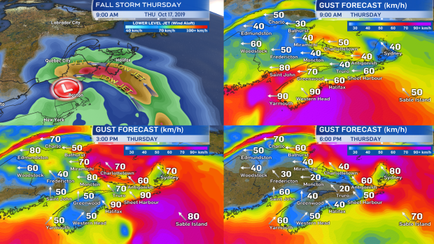
One of the more concerning aspects of the Thursday fall storm is the presence of a low-level jet. You can think of the low-level jet like a mini-jet stream wrapped up in the storm that is aloft of the surface at a general height of between 750 and 1500 metres. That is close enough that, during the passage of the storm, some of those stronger winds can be mixed down towards the surface.

Due to this I would caution that a period of easterly gusts ranging from 70-110 km/h is possible for areas of the Maritimes Thursday. The areas at greatest risk are Nova Scotia, the Bay of Fundy/eastern coastline of New Brunswick, and Prince Edward Island. Exposed areas of eastward-facing coastal locations and higher elevations would be most likely to hit the higher end of the range.
Additionally, the topography of the Cape Breton Highlands will help to produce gusts up to 130 km/h Thursday evening for Inverness County - Mabou and north.
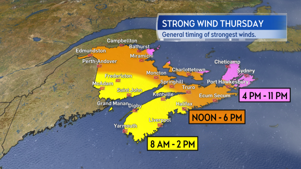
The image below shows my general expectations for the period of time I expect winds to ramp up to peak for various areas of the region. Note that the period of strongest gusts shouldn't last much longer than two hours for any given location. As an example, I expect winds for Halifax to increase through the morning, hitting a peak between noon and 2 p.m., then diminishing.

Impacts from these type of wind events in the past have included a risk of power outages and disruption to travel services such as airports, ferries, and bridges (restriction to high-sided vehicles mostly). It is also highly advisable to secure light objects and fall decorations on your property.
Environment Canada has already issued wind warnings for the southwestern corner of Nova Scotia and Inverness County, Cape Breton. A special weather statement remains in effect for the remainder of the Maritimes, cautioning on the heavy rain and strong winds Thursday. While wind is likely to have the larger impact in the region, periods of heavy rain could lead to ponding water and reduced traction on roads.


