Kalin's Call: Special weather statements remain in effect for all three Maritime provinces
 A man uses a snow blower in front of the Coles building in downtown Charlottetown on Nov. 30, 2016. (John Morris / THE CANADIAN PRESS)
A low-pressure system east of Florida will merge with a cold front to develop into a powerful winter storm that will move northward, just off the eastern U.S. seaboard, before crossing Nova Scotia into the Gulf of St. Lawrence by Sunday.
The central pressure of the storm, a measure of its strength, will fall rapidly Friday into Saturday - classic nor’easter development. You may hear this system referred to as a “weather bomb” which is a reference to the speed at which it develops, including a drop of central pressure by more than 24 millibars in 24 hours.
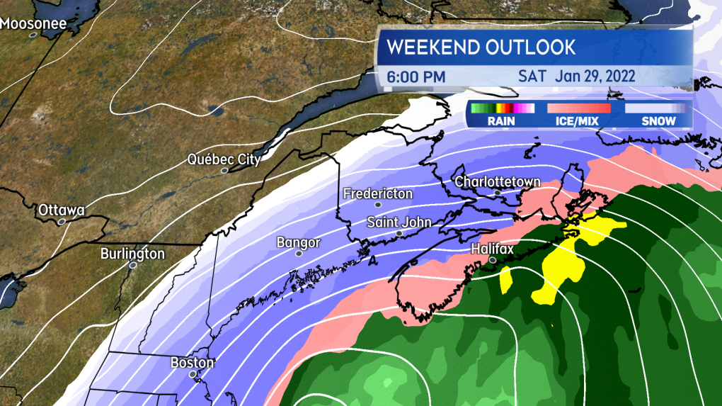
Weather conditions deteriorate in the Maritimes Saturday morning through afternoon.
Heavier snow arrives for Nova Scotia Saturday morning. Heavier snow reaches New Brunswick and Prince Edward Island Saturday afternoon. Much of Nova Scotia turns through ice pellets and freezing rain, to rain Saturday afternoon. Ice pellets, freezing rain, and rain mixing in for P.E.I. Saturday evening. Snow continues for New Brunswick into Sunday morning. The mix of precipitation in the Maritimes clears west-to-east Sunday morning and afternoon. A quick fall in temperatures, back below zero, on Sunday for Nova Scotia and P.E.I. will turn wet and slushy surfaces to ice.
The centre of the storm passes near the South Shore of Nova Scotia before crossing northern areas of that province and P.E.I. on the way into the Gulf of St. Lawrence.
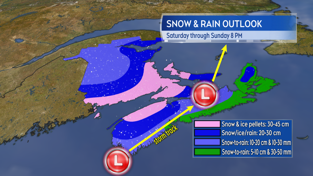
The track of the storm looks like it will hug the South Shore of Nova Scotia before crossing the north of the mainland and P.E.I. on the way into the Gulf of St. Lawrence. That passage is favourable for higher snowfall totals in western/northern Nova Scotia, southern/eastern New Brunswick, as well as P.E.I. Snow accumulation tapers lower towards the Atlantic coastline of Nova Scotia and the east of the province, including Cape Breton, as a quicker turn to rain will occur. Snowfall will taper lower into the northwest of New Brunswick being on the fringe of the storm.
Localized flooding is a risk where the system turns to heavy rain for Nova Scotia. The ground is frozen and drainage systems may be blocked by snow and ice.
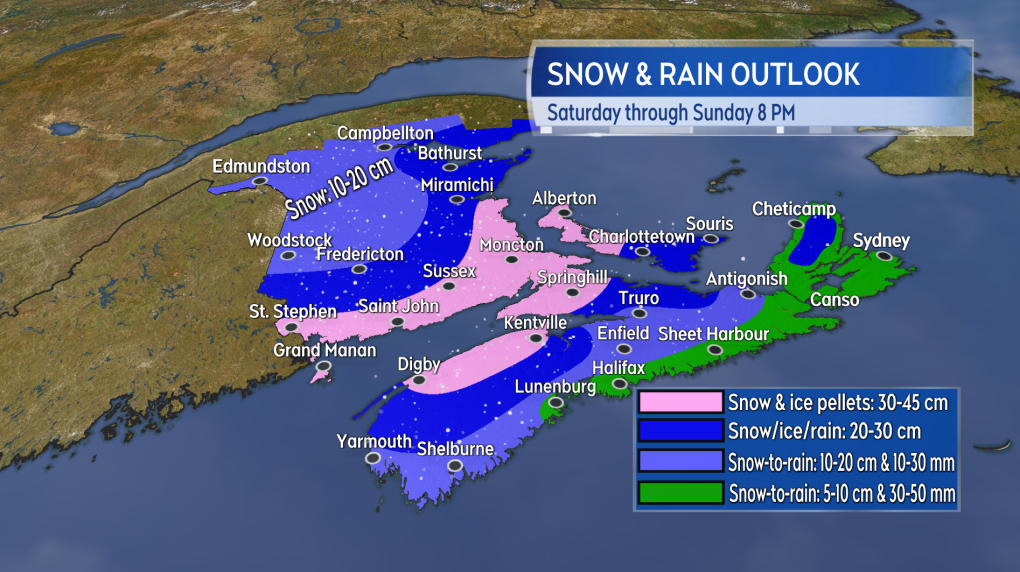
The most snow accumulation still looks likely in western/northern Nova Scotia, southern/eastern New Brunswick, and Prince Edward Island.
Living up to the name, there will be a period of stronger winds from the north and northeast during the passage of the nor’easter. Expect those winds to ramp up Saturday afternoon into night. Widespread gusts of 50 to 80 km/h can be expected with exposed areas of the coast peaking 80 to 100 km/h. Northern Inverness County in Cape Breton will hit gusts above 100 km/h Saturday evening and night due to the topography of the Highlands. Visibility will be reduced in blowing snow and rain. You may want to plan to avoid or limit unnecessary travel Saturday afternoon and night if you are in an area expecting the heavier snow or heavier mix of precipitation.
Winds will turn northwest and west on Sunday diminishing through the day.
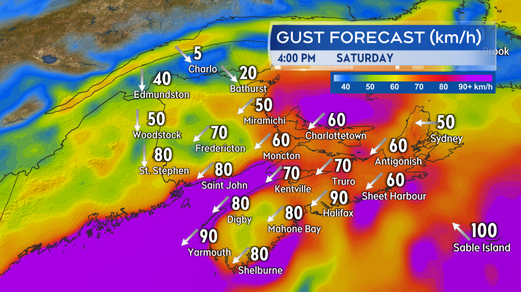
A period of strong northeast winds is expected late Saturday afternoon, evening, and night.
Special Weather Statements remain in effect for all three Maritime provinces. In the statements, Environment Canada advised the public to monitor the forecast and any weather alerts issued in the coming days. I’ll have daily updates on CTV Atlantic news programming and online.


CTVNews.ca Top Stories

More than 115 cases of eye damage reported in Ontario after solar eclipse
More than 115 people who viewed the solar eclipse in Ontario earlier this month experienced eye damage after the event, according to eye doctors in the province.
Last letters of pioneering climber who died on Everest reveal dark side of mountaineering
George Mallory is renowned for being one of the first British mountaineers to attempt to scale the dizzying heights of Mount Everest during the 1920s. Nearly a century later, newly digitized letters shed light on Mallory’s hopes and fears about ascending Everest.
Toxic testing standoff: Family leaves house over air quality
A Sherwood Park family says their new house is uninhabitable. The McNaughton's say they were forced to leave the house after living there for only a week because contaminants inside made it difficult to breathe.
Decoy bear used to catch man who illegally killed a grizzly, B.C. conservation officers say
A man has been handed a lengthy hunting ban and fined thousands of dollars for illegally killing a grizzly bear, B.C. conservation officers say.
B.C. seeks ban on public drug use, dialing back decriminalization
The B.C. NDP has asked the federal government to recriminalize public drug use, marking a major shift in the province's approach to addressing the deadly overdose crisis.
Sophie Gregoire Trudeau on navigating post-political life, co-parenting and freedom
Sophie Gregoire Trudeau says there is 'still so much love' between her and Prime Minister Justin Trudeau, as they navigate their post-separation relationship co-parenting their three children.
An emergency slide falls off a Delta Air Lines plane, forcing pilots to return to JFK in New York
An emergency slide fell off a Delta Air Lines jetliner shortly after takeoff Friday from New York, and pilots who felt a vibration in the plane circled back to land safely at JFK Airport.
OPP responds to apparent video of officer supporting anti-Trudeau government protestors
The Ontario Provincial Police (OPP) says it's investigating an interaction between a uniformed officer and anti-Trudeau government protestors after a video circulated on social media.
'I was scared': Ontario man's car repossessed after missing two repair loan payments
An Ontario man who took out a loan to pay for auto repairs said his car was repossessed after he missed two payments.
Shopping Trends
The Shopping Trends team is independent of the journalists at CTV News. We may earn a commission when you use our links to shop. Read about us.


Toronto
-
More than 115 cases of eye damage reported in Ontario after solar eclipse
More than 115 people who viewed the solar eclipse in Ontario earlier this month experienced eye damage after the event, according to eye doctors in the province.
-
Propane cylinder source of loud boom in Hamilton: police
A loud boom heard by residents across Hamilton was caused by a ‘busted or shredded’ propane cylinder, police say.
-
'Extremely traumatizing:' Boy, 11, struck by transport truck in Etobicoke
An 11-year-old boy struck by a transport truck in Etobicoke on Friday morning suffered critical injuries and is receiving treatment at a Toronto trauma centre, police say.
Calgary
-

Stabbing at Calgary Value Village under investigation by police
Calgary police took two people into custody on Friday after a stabbing in the community of Haysboro.
-
Warmer, windy Saturday ahead for Calgary
It will warm up tomorrow, but it will also be gusty at times.
-
Boil water advisory lifted in Rocky View County
A boil water advisory has been lifted for residences supplied by Salt Box Coulee Waterworks System in Rocky View County.
Edmonton
-

Cat who jumped from burning balcony will recover: management company
A cat that jumped from the balcony of a burning building in downtown Edmonton on Thursday afternoon will make a full recovery, building officials say.
-
'So damn undemocratic': Edmonton mayor reacts to legislation granting province power to fire councillors or veto local bylaws
A bill that would empower the Alberta government to remove elected municipal officials or strike down local bylaws is an "attack on local democracy," says the capital city's mayor.
-
Oilers focus on better start for Game 3 vs. Kings
The Oilers — overtime losers of Game 2 in Edmonton — have to find a way to follow their own advice to tame the Los Angeles Kings on the latter's home ice the next two games.
Montreal
-

'Do I ghost her again?': Quebec minister's office ignores questions on housing as a human right
The office of Quebec Housing Minister France-Élaine Duranceau prefers to openly ignore journalists' requests.
-
Taylor Swift dons Montreal designer's dress in 'Fortnight' video
A pair of Montreal designers' work has now been viewed over 41 million times. Taylor Swift dons a Victorian throwback black gown in her latest music video, 'Fortnight', designed by UNTTLD due Simon Belanger and Jose Manuel Saint-Jacques.
-
Truck driver dies in workplace accident at Port of Montreal
Officials with Quebec's workplace safety board were sent to the Port of Montreal on Friday after a truck driver was killed on the job.
Ottawa
-

Trucker from Newfoundland missing in eastern Ontario
Ontario Provincial Police are asking for the public's help in locating a missing man from Newfoundland who disappeared in eastern Ontario.
-
'Too young to have breast cancer': Rates among young Canadian women rising
Breast cancer rates are rising in Canada among women in their 20s, 30s and 40s, according to research by the University of Ottawa (uOttawa).
-
Queen’s University names award-winning journalist Shelagh Rogers as next chancellor
Queen’s University says renowned Canadian broadcaster and alumna, Shelagh Rogers will serve as its 16th chancellor starting July 1.
London
-
Increased police presence in Tillsonburg
Police said they were called to a weapons-related incident on Morning Glory Drive around 1:30 p.m. Friday.
-
Pilot project sees Londoners in apartments and condos join green bin organic waste program
Three months after the launch of curbside green bin collection for homeowners, a pilot project will analyze expanding the program to include medium to high-density apartments and condominiums.
-
Portion of Highway 401 reopens following fatal crash
A fatal crash in Thames Centre closed down a portion of Highway 401 westbound. Around 2:15 a.m., first responders were called to westbound lanes of the highway between Culloden and Putnam Roads for a two-vehicle crash.
Barrie
-

Gateway Casinos considers relocating from Innisfil venue
With its Innisfil location’s lease set to expire within the next five years, Gateway Casinos is eyeing a plan to move.
-
Highway 400 crash closes section of highway
A crash in Innisfil on Friday has closed a section of Highway 400 in both directions.
-
OPP responds to apparent video of officer supporting anti-Trudeau government protestors
The Ontario Provincial Police (OPP) says it's investigating an interaction between a uniformed officer and anti-Trudeau government protestors after a video circulated on social media.
Northern Ontario
-

Northern Ont. hunters fined $8,500 for illegal moose hunt
Two hunters from North Bay, Ont., and a third from Temagami pled guilty recently to offences they committed during a 2022 moose hunt.
-
Sophie Gregoire Trudeau on navigating post-political life, co-parenting and freedom
Sophie Gregoire Trudeau says there is 'still so much love' between her and Prime Minister Justin Trudeau, as they navigate their post-separation relationship co-parenting their three children.
-
Police in northern Ont. attacked by person they found lying in the street
Ontario Provincial Police responding to a disturbance in West Nipissing this week discovered a conscious person lying in the street.
Kitchener
-

Delays in Queen Victoria statue consultation have become 'disrespectful,' say Kitchener Indigenous community leaders
More than a year has passed since the City of Kitchener announced it was pausing community consultations on the future of the Queen Victoria statue in Victoria Park, and there is still no timeline for a resumption of the process.
-
250 Frederick Street ownership tied to alleged reno-victions in London, Hamilton
An investor with ties to apartment buildings across Ontario appears to be connected to 250 Frederick Street in Kitchener.
-
About 10 companies interested in Wilmot land, says Minister of Economic Investment
Ontario’s Minister of Economic Investment, Job Creation and Trade says a number of companies have shown interest in a tract of land the Region of Waterloo is trying to assemble in Wilmot Township.
Windsor
-

NFL Draft: Windsor welcomes as Detroit overflows with fans
All the excitement of the NFL Draft has officially descended upon Detroit, with Windsor welcoming the spillover.
-
Julien’s House opens new Nick Dyer Clubhouse to offer peer-to-peer grief support
A ribbon cutting to celebrate the opening of a new grief support centre on Baseline Road in Windsor marked a bittersweet moment for many at Julien’s House Friday morning.
-
Windsor police seize $120,000 in drugs
Windsor police have arrested two people after seizing $120,000 in illegal drugs.
Winnipeg
-

'All these families are now scrambling': Gimli parents concerned about policy changes to child care
Parents in Gimli who rely on child care before and after school are sounding the alarm over policy changes coming in September.
-
Dishing out history: A look back at defunct restaurants in Winnipeg
Take an illustrated look back at the culinary history of Winnipeg.
-
Manitobans bringing home less money after taxes according to new survey
Manitobans brought home an average of $2,200 less after taxes in 2022 compared to the previous year.
Regina
-

Man charged with murder, victim identified in southeast Sask. homicide case
RCMP have identified 28-year-old Brianna Hayes from Oxbow, Sask. as the victim in an ongoing homicide investigation in the province’s southeast. As a result, police have charged 24-year-old Taylor Japp, also from Oxbow with second degree murder, an RCMP news release said.
-
Lego therapy program expands through Yorkton SaskAbilities
Youth in Yorkton can now access a new Lego Therapy program in their community through SaskAbilities.
-
Regina police officer injured after another officer's gun accidentally fired
A Regina police officer was injured after another officer's gun was accidentally fired while conducting a search warrant early Friday morning.
Saskatoon
-

Saskatchewan's $90M social services initiative underway
Over six months after Saskatchewan's government announced a significant $90 million investment in social services, the initiative is reportedly making progress.
-
Saskatoon police investigating after body found at recycling facility
The Saskatoon Police Service (SPS) and Saskatchewan Coroners Service are investigating after a woman’s body was found at a recycling facility Friday morning.
-
Four people arrested after attempted armed robbery in Saskatoon
Four people, including two teen girls, were arrested and charged after an attempted armed robbery on Thursday evening.
Vancouver
-

1 man in custody after suspicious fire at Surrey townhome, RCMP say
A fire that displaced three families from a townhouse complex in Surrey's Newton neighbourhood Friday afternoon is considered suspicious, local Mounties say.
-
B.C. composer with debilitating condition realizes dream of scoring movie
When Art Kinarthy embarked upon this quest, he never could have imagined where it would ultimately lead.
-
'It's brutal': Family pleads for help finding missing Abbotsford man
Wesley Bosman was last seen leaving his home around 3 a.m. on Tuesday near Ash Street and Cedar Avenue.
Vancouver Island
-

B.C. seeks ban on public drug use, dialing back decriminalization
The B.C. NDP has asked the federal government to recriminalize public drug use, marking a major shift in the province's approach to addressing the deadly overdose crisis.
-
Saanich to consider amalgamating fire department with Victoria, Esquimalt, Oak Bay
Saanich council will be discussing a report Monday prepared by Saanich Fire Chief Michael Kaye on the merits of amalgamating the fire departments of Victoria, Oak Bay, Esquimalt and Saanich.
-
B.C. composer with debilitating condition realizes dream of scoring movie
When Art Kinarthy embarked upon this quest, he never could have imagined where it would ultimately lead.
Kelowna
-

B.C. man rescues starving dachshund trapped in carrier: BC SPCA
An emaciated dachshund is now recovering thanks to a Good Samaritan who found the pup near a biking trail in Kelowna, according to the BC SPCA.
-
Search crews called in after missing Kelowna senior's truck found
Search and rescue crews have been called in after a vehicle belonging to a missing senior was located near a rural intersection outside of Kelowna Tuesday.
-
Homicide investigation underway after body found near Kelowna, B.C.
Major crime detectives in British Columbia are investigating a suspected homicide after a body was found in a remote area southeast Kelowna over the weekend.


