With the components for our weekend storm beginning to move into continental North America, there is increasing confidence in the general impacts the system will have on the Maritimes.
There hasn’t been a big change in the timing of the storm. It is a Sunday-into-Monday weather event. The intensity of the snow, rain, and wind look to increase Sunday afternoon into Monday night and morning.
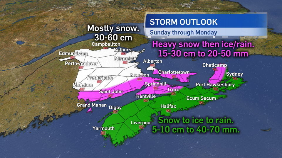
The heaviest snowfall looks likely through central and northern areas of New Brunswick, with a general swath of 30 to 60 cm of snow and a risk of higher local amounts. Southern areas of the province will likely see significant mixing in of ice pellets, freezing rain, and rain. While that will reduce overall snowfall totals, they may still range from 15 to 30 cm.
Much of Prince Edward Island will see similar conditions, with a turn from snow to ice to rain, but not before 10-20 cm of accumulation with higher amounts possible in Prince County.
Nova Scotia will start as a period of intense accumulating snow before a turn through ice pellets/freezing rain to heavy rain. The rain, which may generally total 40 to 70 mm, should be enough to wash away initial snow accumulation, but will bring a risk of local flooding.
Winds will increase Sunday afternoon and night out of the south and southeast for Nova Scotia and Prince Edward Island. Peak gusts for coastal areas and higher terrain 80 to 100 km/h with gusts exceeding 150 km/h in northern Inverness County, Cape Breton Sunday night due to topography of the Highlands.
Wind direction will be more variable for New Brunswick, turning south and southeast for southern areas of the province, while remaining more east and northeast for northern areas. Gusts for New Brunswick will peak 40 to 70 km/h inland with coastal areas at risk of gusts 80 to 100 km/h. The highs winds will drive snow and rain, reducing visibility, contributing to travel service delays, and bringing an increased risk of power outages. A rough and pounding surf will be present on the coast.
A turn to northerly winds as the storm begins to clear Monday will usher in very cold air to the region. A hard freeze of slushy or wet surfaces is a risk Monday afternoon through night.
Due to the nature of this type of weather system it would be a very good idea to watch for changes in the forecast into the weekend. The latest watches and warnings will be posted at www.weather.gc.ca.
Other simple precautions to take include being ready to go at least 72 hours without power or running water (should be a year-round preparation), ensure drainage on around property/residences are as clear of snow and ice as possible, and be ready to adjust travel plans Sunday into the start of next week.
While a strong winter storm it is one that is well within our possibility any given winter season, preparation and patience will be the best ways to get through it safely and with minimal stress.


