Late fall storm brings gusts above 100 km/h and record high temperatures
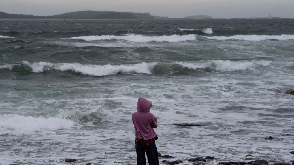
 A person watches waves crash near the shoreline at Point Pleasant Park in Halifax on Sunday, October 8, 2023. (THE CANADIAN PRESS/Darren Calabrese)
A strong low pressure system is passing through northern New Brunswick towards the Gaspe Peninsula in Quebec on Monday.
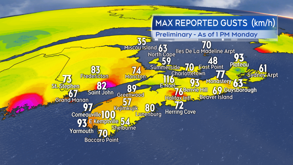
That track places much of the Maritimes on the rainy and windy side of the storm. Widespread southerly gusts in southern New Brunswick, Nova Scotia, and Prince Edward Island reaching or exceeding 70 km/h.
Some of the peak gusts have been reported in excess of 100 km/h in Nova Scotia in areas where topography is helping to enhance the winds.
As an example, a few personal weather stations near the Minas Basin and the North Shore of Nova Scotia have reported those 100+ km/h gusts as the south wind downslopes towards the coast.
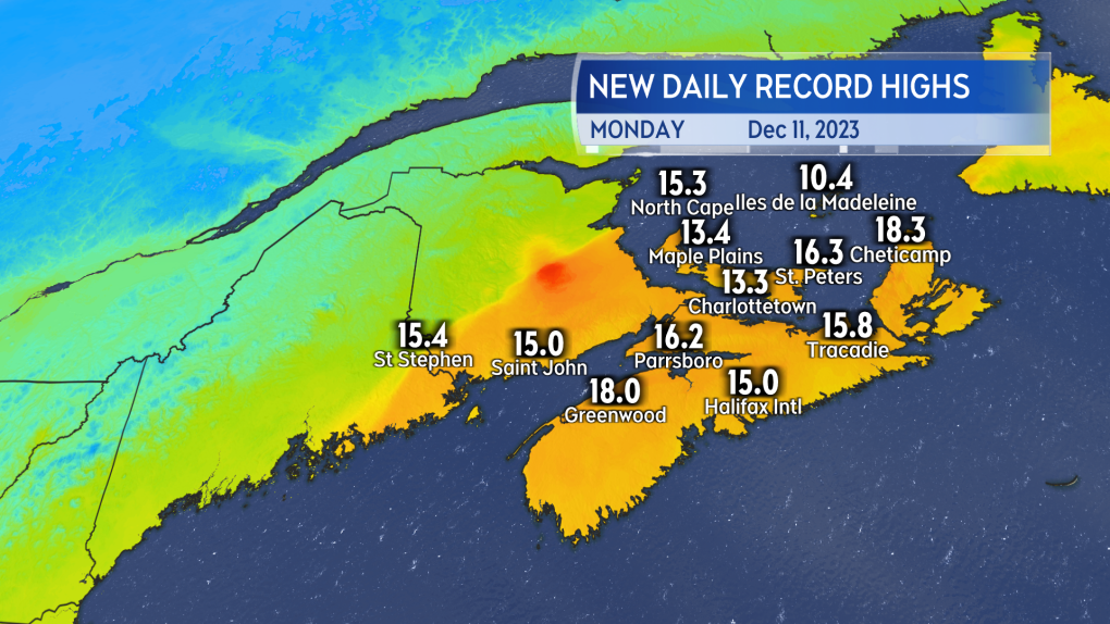
 A sampling of some of the stronger winds gusts reported in the Maritimes as of 1 p.m. Monday. (CTV/Kalin Mitchell)Along with power outages and travel service delays (bridge traffic restrictions, ferry services) the strong south wind has brought mild air up the eastern seaboard. That air allowed high temperatures on Monday for much of the Maritimes to climb into the low-to-high teens. Some of those set new daily high temperature records for a December 11. As of 1 p.m. at Cheticamp, N.S., was the warmest spot in Canada with a temperatures of 18.3 degrees.
 New high temperature records set for a December 11 in the Maritimes. (CTV/Kalin Mitchell)The powerful wind will peak for New Brunswick and mainland Nova Scotia Monday afternoon. The wind peaking for P.E.I. and Cape Breton Monday evening. Wind turns westerly and diminishes overnight for the entirety of the Maritimes. The west wind returns some colder air with low temperatures expected to fall to or below freezing for some areas by Wednesday morning. Watch for any standing wet surfaces to develop icy spots.
 The strongest winds and what is left of the rain shift into eastern parts of the Maritimes Monday evening. The rain and wind then both diminish through the night. (CTV/Kalin Mitchell)Rain with the storm has been heaviest in the province of New Brunswick. Early Monday morning reports already had amounts of 30 to 60 mm down for parts of the province. Additional rain has fallen since then with more to come Monday afternoon. Rainfall Warnings in place by Environment Canada for the province call for some totals of 40 to 70 mm.
The frozen ground and melting snow and ice may also contribute to more water runoff than would be typical with that amount of rain in a warmer season.
CTVNews.ca Top Stories

'Environmental racism': First Nations leaders claim cancer-causing contamination was covered up
The people of F ort Chipewyan believe the federal government believe the federal government knew its water was contaminated and hid the issue for years. Now the chief of the Athabasca Chipewyan First Nation is leading the call for immediate action.
Death toll from Hurricane Helene rises to 227 as grim task of recovering bodies continues
The death toll from Hurricane Helene inched up to 227 on Saturday as the grim task of recovering bodies continued more than a week after the monster storm ravaged the Southeast and killed people in six states.
Car flies into B.C. backyard, lands upside down
A driver suffered only minor injuries after going airborne in a residential neighbourhood in Maple Ridge, B.C., on Friday, the car eventually landing on its roof in someone’s backyard.
Donald Trump, Elon Musk attend rally at same Pennsylvania grounds where gunman tried to assassinate Trump
Donald Trump returned on Saturday to the Pennsylvania fairgrounds where he was nearly assassinated in July, holding a sprawling rally with thousands of supporters in a critical swing state Trump hopes to return to his column in November's election.
Tax rebate: Canadians with low to modest incomes to receive payment
Canadians who are eligible for a GST/HST tax credit can expect their final payment of the year on Friday.
'No one has $70,000 dollars lying around': Toronto condo owners facing massive special assessment
The owners of a North York condominium say they are facing a $70,000 special assessment to fix their building's parking garage. '$70,000 is a lot of money. It makes me very nervous and stressed out of nowhere for this huge debt to come in,' said Ligeng Guo.
Police ID mom, daughter killed in Old Montreal; video shows person break into building before fatal fire
Police released the identities of the mother and daughter who were killed after a fire tore through a 160-year-old building in Old Montreal on Friday.
Frequent drinking of fizzy beverages and fruit juice are linked to an increased risk of stroke: research
New data raises questions about the drinks people consume and the potential risks associated with them, according to researchers at Galway University in Ireland, in partnership with Hamilton’s McMaster University.
'I screamed in shock and horror': Family faces deadly Vancouver hit-and-run driver during sentencing
The sentencing of the man who pleaded guilty in the deadly hit-and-run in Kitsilano two years ago began on Friday.


