Long weekend weather for the Maritimes expected to be cloudier, breezy, and with a chance of showers
 A pedestrian shields themselves from rain and wind during a rainfall warning in Halifax on Thursday, January 26, 2023. THE CANADIAN PRESS/Darren Calabrese
The weather system that will most influence weather in the Maritimes for the May long weekend is a slow moving low pressure system travelling north and just off the eastern U.S. seaboard.
A quick note on the Bluenose Marathon in Halifax. Runners may appreciate the cloud cover and easterly wind keeping it a touch cooler. The chance of some showers or drizzle means that spectators should be prepared to contend with some periods of wet weather. As it stands, the higher chance of steadier showers is for Sunday.
Saturday
The low will sit just east of Cape Cod on Saturday. It is expected to increase cloud cover across the Maritime region. A chance of showers or patchy drizzle is beginning for Nova Scotia Saturday morning, and a chance of showers or patchy drizzle for southern New Brunswick and Prince Edward Island by Saturday evening.
Temperatures cool compared to Friday due to the increased cloud coverage across the region. A prevailing easterly wind will keep highs in the low-to-mid teens for the Atlantic coastline of Nova Scotia, Prince Edward Island, and the eastern coastline of New Brunswick. Other parts of the Maritimes can expect high temperatures to reach a range of 17 to 21 degrees.
The wind will be steady, with occasional gusts of 20 to 40 km/h. People can expect a bit of a damp feel to the air on Saturday.
 Cloudier on Saturday. A chance of patchy showers and drizzle for the province of Nova Scotia through the day. (CTV/Kalin Mitchell)
Sunday
On Sunday the low pressure system begins to move east and away from the Maritimes. The Maritimes are expected to be mostly cloudy with a continued chance of patchy showers or drizzle for southern New Brunswick, Prince Edward Island, and Nova Scotia for Sunday morning and afternoon. Some partial clearing of the cloud cover starting Sunday afternoon for northern areas of New Brunswick.
Temperature comes down another few degrees for most of the Maritimes. High temperatures will range 10 to 16 degrees except for western areas of New Brunswick. The western half of New Brunswick a touch milder with highs of 17 to 21.
Wind on Sunday will be from the east and northeast. Sustained 10 to 20 km/h with gusts of 20 to 40 km/h. Similar in strength to the wind expected Saturday.
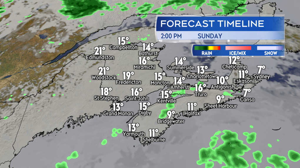 Cloudy conditions with a chance of showers continue on Sunday. Some clearing possible in northern areas of New Brunswick. (CTV/Kalin Mitchell)
Monday
As the low moves eastward a weak ridge of high pressure builds in from the west. A clearing trend is expected to continue for the Maritimes on Monday. New Brunswick and Prince Edward Island should both see sunnier conditions compared to Saturday and Sunday. Nova Scotia may start mostly cloudy Monday but could see the sun start to break through in the afternoon.
With the sun breaking through, the temperatures rise. High temperatures in a range of 17 to 21 degrees for most of the region, where a breeze comes in off of ocean waters, coastal locations could be held between 12 and 17. The warmest temperatures on Monday is expected for Fredericton and west in New Brunswick. That part of the Maritimes could reach 24 to 27.
Wind on Monday becomes lighter and more variable in direction. Wind gusts are expected to reach 10 to 30 km/h.
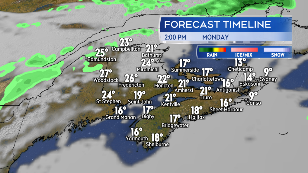 Clearing to a mix of sun and cloud on Monday. Temperatures rise with the sunnier conditions expected. (CTV/Kalin Mitchell)
Fire Danger Forecast
Natural Resources Canada issued a multi-day fire danger forecast. The forecast currently elevates the fire danger rating for southern New Brunswick and Prince Edward Island on Saturday. The forecast then has the entirety of the Maritimes into a low-to-moderate rating on Sunday. The rating then rises back to moderate for New Brunswick and Prince Edward Island on Monday, Nova Scotia remaining with a low rating.
Fire danger can change quickly based on the weather of the day. If planning on outdoor burning or recreation fires be sure to check in daily on provincial and municipal guidelines and restrictions. These are typically updated daily at 2 p.m. and can be found at:
No fire should be left unattended and should be fully extinguished before leaving.


CTVNews.ca Top Stories

Canadian former Olympic snowboarder wanted in Ontario double homicide: DOJ
A Canadian former Olympic snowboarder who is suspected of being the leader of a transnational drug trafficking group that operated in four countries is wanted for allegedly orchestrating the murder of an 'innocent' couple in Ontario in 2023, authorities say.
Ontario school board trustees under fire for $100K religious art purchase on Italy trip
Trustees with an Ontario school board are responding to criticism over a $45,000 trip to Italy, where they purchased more than $100,000 worth of religious statues.
A photographer snorkeled for hours to take this picture
Shane Gross, a Canadian marine conservation photojournalist, has won the title of Wildlife Photographer of the Year.
Tobacco giants would pay out $32.5 billion to provinces, smokers in proposed deal
Three tobacco giants are proposing to pay close to $25 billion to provinces and territories and more than $4 billion to some 100,000 Quebec smokers and their loved ones as part of a corporate restructuring process triggered by a long-running legal battle.
More Trudeau cabinet ministers not running for re-election, sources say shuffle expected soon
Federal cabinet ministers Filomena Tassi, Carla Qualtrough and Dan Vandal announced Thursday they will not run for re-election. Senior government sources tell CTV News at least one other, Marie-Claude Bibeau, doesn't plan to run again, setting the stage for Justin Trudeau to shuffle his cabinet in the coming weeks.
Robert Pickton's handwritten book seized after his death in hopes of uncovering new evidence
A handwritten book was seized from B.C. serial killer Robert Pickton's prison cell following his death earlier this year, raising hopes of uncovering new evidence in a series of unprosecuted murders.
Former members of One Direction say they're 'completely devastated' by Liam Payne's death
The former members of English boy band One Direction reacted publicly to the sudden death of their bandmate, Liam Payne, for the first time on Thursday, saying in a joint statement that they're 'completely devastated.'
Israel says it has killed top Hamas leader Yayha Sinwar in Gaza
Israeli forces in Gaza killed top Hamas leader Yahya Sinwar, a chief architect of last year's attack on Israel that sparked the war, the military said Thursday. Troops appeared to have run across him unknowingly in a battle, only to discover afterwards that a body in the rubble was Israel's most wanted man.
Indian government employee charged in foiled murder-for-hire plot in New York City
The U.S. Justice Department announced criminal charges Thursday against an Indian government employee in connection with a foiled plot to kill a Sikh separatist leader living in New York City.
Shopping Trends
The Shopping Trends team is independent of the journalists at CTV News. We may earn a commission when you use our links to shop. Read about us.


Toronto
-
Canadian former Olympic snowboarder wanted in Ontario double homicide: DOJ
A Canadian former Olympic snowboarder who is suspected of being the leader of a transnational drug trafficking group that operated in four countries is wanted for allegedly orchestrating the murder of an 'innocent' couple in Ontario in 2023, authorities say.
-
OHL responds to CTV W5 investigation into alleged sexual assault by former junior hockey players
The Ontario Hockey League (OHL) has released a statement in response to a recent CTV W5 investigation into an alleged sexual assault in 2014.
-
More than 100 school bus routes across Toronto cancelled Friday
More than 100 school bus routes in Toronto are cancelled on Friday due to ongoing vehicle issues.
Calgary
-

Cause of SAIT death remains 'undetermined' following autopsy
Calgary police say despite an autopsy being conducted, it's not yet known what caused the death of a young woman at the Southern Alberta Institute of Technology.
-
'My kids are really heartbroken': Calgary dad pleads with thieves who stole colourful car
A Calgary dad is pleading to have his modified 1999 Honda Civic returned after it was stolen by thieves in the community of Legacy over the Thanksgiving long weekend.
-
New $1.4B cancer centre opens in Calgary
After more than seven years of construction, a new cancer centre in Calgary will open to patients and researchers.
Edmonton
-

Drowning death of 5-year-old at Wabamun Lake believed to be criminal: RCMP
RCMP are looking for witnesses in what they believe was the criminal death of a five-year-old girl at Wabamun Lake on Sunday.
-
Edmonton education support staff vote overwhelmingly in favour of strike action
Edmonton education support staff could be heading to the picket lines.
-
Suspects in targeted Duggan shooting sought by Edmonton police
Edmonton police are hoping the public can help identify people involved in a shooting in the southside neighbourhood of Duggan last month.
Montreal
-

Five arrested in connection with extortion targeting Montreal businesses
Montreal police arrested five suspects following two separate investigations involving crimes targeting a Verdun bar and a downtown restaurant.
-
FIQ accepts conciliator's recommendation to renew collective agreement
Nurses and other Quebec health-care workers voted 66.3 per cent in favour of a conciliator's recommendation to renew their collective agreement after several months of negotiations with the provincial government.
-
Car torched at home of owner of Old Montreal buildings struck by deadly arsons
Police are investigating a fire at a home in Dorval owned by Emile Benamor, the owner of the two Old Montreal buildings that were allegedly set on fire in the past year, killing nine.
Ottawa
-

Ottawa doctors see spike in demand for sick notes from public servants
Some doctors in Ottawa say the pile of paperwork they're doing every day has been steadily growing as more public service workers seek doctor's notes in order to receive accommodations to work from home.
-
Three suspects in multiple frauds on Baseline Road sought by Ottawa police
The Ottawa Police Service is asking the public for help in identifying three suspects involved in an alleged theft and multiple fraud incidents that happened last month in the city's west end.
-
What La Nina could mean for Ottawa's winter weather
Environment Canada's senior weather climatologist says Ottawa will see "more of a winter than last year," as it experiences a possible La Nina weather event this year
London
-

Extensive damages caused in West Lorne residential fire
West Elgin fire crews say flames were pushing through the roof when they arrived on Graham Road just after 2:00 p.m.
-
Five people taken to hospital after two-vehicle crash
OPP closed a section of road in Middlesex County on Thursday morning following a crash.
-
Central witness testifies at London bush party shooting trial
The first day of testimony at the fatal bush bash shooting trial heard from a 21-year-old woman who was at the party when things turned deadly.
Barrie
-

Orillia man, 32, charged in Highway 12 crash that claimed senior's life
An Orillia man has been arrested four months after a collision on Highway 12 in Ramara Township that police say claimed the life of a senior.
-
How to recognize the warning signs of online scams
On Thursday, provincial police issued a reminder to the public about the warning signs of fraud involving online transactions and financial transfers.
-
Orillia teen creates free open fridge program to help combat food insecurity
At 17 years old, Myles Kozinski is making a difference by creating the Orillia community fridge program.
Northern Ontario
-
Canadian former Olympic snowboarder wanted in Ontario double homicide: DOJ
A Canadian former Olympic snowboarder who is suspected of being the leader of a transnational drug trafficking group that operated in four countries is wanted for allegedly orchestrating the murder of an 'innocent' couple in Ontario in 2023, authorities say.
-
Company fined $80K after worker seriously injured at northern Ont. job site
A Quebec-based company that supplies hydro turbines and generators has been fined $80,000 after a millwright was critically injured at a job site last year in Iron Bridge, Ont.
-
Fed up police in northern Ont. arrest bored and drunk person making false 911 calls
An intoxicated person living on Highway 17 in Spragge, Ont., has been arrested for making repeated false 911 calls in a span of several hours Oct. 11.
Kitchener
-

Ontario school board trustees under fire for $100K religious art purchase on Italy trip
Trustees with an Ontario school board are responding to criticism over a $45,000 trip to Italy, where they purchased more than $100,000 worth of religious statues.
-
Blood found on clothing in Erick Buhr's bedroom after his grandmother's death, police testify at trial
Two police officers took the stand Thursday to describe what they found on Erick Buhr's clothing after his grandmother, Viola Erb, was attacked.
-
Canadian former Olympic snowboarder wanted in Ontario double homicide: DOJ
A Canadian former Olympic snowboarder who is suspected of being the leader of a transnational drug trafficking group that operated in four countries is wanted for allegedly orchestrating the murder of an 'innocent' couple in Ontario in 2023, authorities say.
Windsor
-

'Scary': shooting under investigation in east Riverside
Windsor police are investigating shots fired in a quiet east Riverside neighbourhood.
-
Momentary lapse in focus or undue care and attention? Closing arguments complete in Chatham trial
Closing arguments are complete in a careless driving trial in Chatham.
-
Revived Canadian wrestling promotion ready to relaunch in Windsor this weekend
The revival and relaunch of Maple Leaf Wrestling, under the new name, Maple Leaf Pro (MLP) Wrestling, is set to take shape this weekend at St. Clair College in Windsor.
Winnipeg
-

Six bison killed in illegal hunt, Manitoba man charged: RCMP
A 52-year-old man has been charged after six bison were killed in an illegal hunt on a Manitoba farm.
-
'It's desperate times': Surge in strays and surrendered pets putting strain on animal shelters
There are 42 stray dogs in the care of the Winnipeg Animal Services – nearly double the facility’s normal capacity.
-
Winnipeg & Hallmark: A holiday movie happily ever after
Over the past several years, the Winnipeg has been the backdrop for dozens of Hallmark holiday movies and this year several more are being added to the growing list of feel-good, seasonal films that are Manitoba-shot.
Regina
-

5-day-old baby found safe after Amber Alert cancelled, suspect in custody
An Amber Alert issued by Waskesiu Lake RCMP for a 5-day-old baby boy has been cancelled.
-
Sask. Party leader promises to swiftly introduce school changeroom policy if re-elected
Saskatchewan Party Leader Scott Moe announced Thursday that if re-elected his party's 'first order of business' would be to introduce a policy that would ban 'biological males' from changing with 'biological females' in school changerooms.
-
Yorkton Chamber hosts provincial forum
Yorkton’s Chamber of Commerce hosted an “All Candidates Forum” Wednesday evening. With over 200 people in attendance, residents said they feel more confident in who to vote for in the upcoming provincial election.
Saskatoon
-
5-day-old baby found safe after Amber Alert cancelled, suspect in custody
An Amber Alert issued by Waskesiu Lake RCMP for a 5-day-old baby boy has been cancelled.
-
Saskatoon mayoral candidate Cary Tarasoff unveils financial platform with critiques of city spending
Saskatoon mayoral candidate Cary Tarasoff says it's time for the city to get its finances back on track after building a reputation of overspending and mismanaging costly projects.
-
Police investigating after human remains found in Prince Albert
The Prince Albert Police Service is investigating after unidentified human remains were found in the city.
Vancouver
-

David Eby reacts to B.C. billionaire Chip Wilson's pre-election op-ed
B.C. NDP Leader David Eby slammed his billionaire constituent Chip Wilson – again – on the campaign trail, following the publication of an op-ed by the Lululemon founder.
-
B.C. south and central coast under flood watch as atmospheric river approaches
Forecasters have elevated their warnings about an atmospheric river system that is expected to hit coastal British Columbia on Friday, bringing potential flooding, heavy rain and high winds.
-
Real estate agent submitted 'falsified' financial information on mortgage applications, B.C. regulator finds
The agency that regulates real estate agents in B.C. has cancelled the licences of a man and his personal real estate corporation after he admitted to using an unregistered mortgage broker and submitting "falsified income and savings information" on two mortgage applications.
Vancouver Island
-
David Eby reacts to B.C. billionaire Chip Wilson's pre-election op-ed
B.C. NDP Leader David Eby slammed his billionaire constituent Chip Wilson – again – on the campaign trail, following the publication of an op-ed by the Lululemon founder.
-
B.C. south and central coast under flood watch as atmospheric river approaches
Forecasters have elevated their warnings about an atmospheric river system that is expected to hit coastal British Columbia on Friday, bringing potential flooding, heavy rain and high winds.
-
CP Railway adjusts safety measures following B.C. train crash: safety board
The Transportation Safety Board says a mistake by a Canadian Pacific Railway supervisor set off a crash between a freight train and a railway work vehicle in Cache Creek, B.C.
Kelowna
-

B.C. homeowner astounded someone managed to steal one of his prized giant pumpkins
Dave Lindsey began growing giant pumpkins to bring a bit of magic to his grandkids' Halloween.
-
B.C. man gets prison sentence, fine for using fake names to buy guns in the U.S.
A U.S. District Court judge in Montana has sentenced a 27-year-old man from Kelowna, B.C., to 18 months in prison for using fake names to buy guns with the aim of selling them in Canada.
-
2nd-degree murder charge laid nearly 2 years after Kelowna stabbing
Nearly two years after a man was stabbed to death in downtown Kelowna, RCMP have made an arrest in the case.


