Maritimes to see heavy rain and strong winds Monday
 People in Halifax walk through heavy rain on Sept. 13, 2023. (CTV/Jonathan MacInnis)
A strengthening low pressure system will move out of the northeastern U.S., across northern New Brunswick, and over the Gaspe Peninsula of Quebec on Monday.
With the Maritimes on the eastern side of the system, rain and a high and gusty southerly wind is expected. Heavier snow from the storm across eastern Quebec and into Labrador.
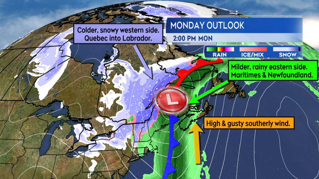 A strong low moves through Maine and towards northern New Brunswick Monday. High wind and heavy rain expected for parts of the Maritimes. (CTV/Kalin Mitchell)The wind is likely to be the most widespread issue for the Maritimes. Strong from the south it may peak with gusts of 70 to 110 km/h. The strongest of the gusts, those approaching or exceeding 100 km/h, are most likely for exposed areas of the coast and higher terrain.
Similar weather systems with similar strength winds have caused power outages in the region in the past. Likewise, similar strength winds have caused delays or restrictions to transportation services in the region including bridges and ferry service.
Based on current timing the stronger winds arrive in southwestern New Brunswick and southwestern Nova Scotia Monday morning. From there it develops west-to-east across the Maritimes through the day. The wind then gradually diminishes Monday evening and night with Cape Breton and Prince Edward Island out of the stronger winds last. It would be a good idea to secure loose, easily wind blown objects such as holiday decorations before Monday.
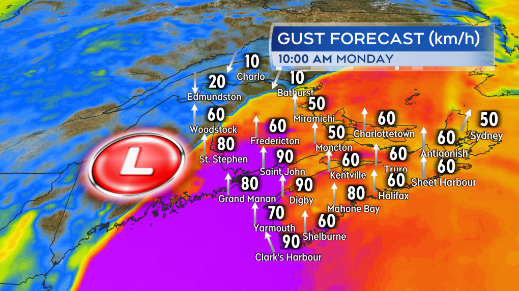 The stronger southerly wind arriving in the southwest of the region Monday morning. Strong winds then develop west-to-east through the day. (CTV/Kalin Mitchell)Rain looks to range 10 to 30 mm for Nova Scotia and Prince Edward Island. Heavier rain is a risk for New Brunswick. Some guidance showing possible totals reaching or exceeding 50 mm for areas of that province. A snowfall of 5 to 10 cm may follow the rain for the northwestern corner of New Brunswick Monday evening and night.
Something to keep in mind with the rain. We do have snow and ice on the ground, as that melts it could add to runoff. The ground is also frozen and that limits its ability to absorb rainfall. We do have above freezing temperatures in the forecast Sunday and into Sunday night which will hopefully allow for some of the snow and ice to melt before the rain arrives in earnest on Monday.
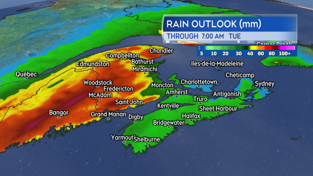 The greatest chance of rain totals approaching or exceeding 50 mm is in New Brunswick. Heavy snow from the system is a risk for eastern Quebec and Labrador. (CTV/Kalin Mitchell)A number of watches have been posted by the National Weather Service in the state of Maine ahead of the storm including a Flood Watch and High Wind Watch. As of 4 p.m. Friday no weather alerts had been issued for the Maritimes by Environment Canada. It is recommended to check on the Monday forecast for your area at least a few times through the weekend.
Shopping Trends
The Shopping Trends team is independent of the journalists at CTV News. We may earn a commission when you use our links to shop. Read about us.


CTVNews.ca Top Stories

Prime Minister Trudeau meets Donald Trump at Mar-a-Lago
Prime Minister Justin Trudeau landed in West Palm Beach, Fla., on Friday evening to meet with U.S.-president elect Donald Trump at Mar-a-Lago, sources confirm to CTV News.
'Mayday! Mayday! Mayday!': Details emerge in Boeing 737 incident at Montreal airport
New details suggest that there were communication issues between the pilots of a charter flight and the control tower at Montreal's Mirabel airport when a Boeing 737 made an emergency landing on Wednesday.
Hit man offered $100,000 to kill Montreal crime reporter covering his trial
Political leaders and press freedom groups on Friday were left shell-shocked after Montreal news outlet La Presse revealed that a hit man had offered $100,000 to have one of its crime reporters assassinated.
Questrade lays off undisclosed number of employees
Questrade Financial Group Inc. says it has laid off an undisclosed number of employees to better fit its business strategy.
Cucumbers sold in Ontario, other provinces recalled over possible salmonella contamination
A U.S. company is recalling cucumbers sold in Ontario and other Canadian provinces due to possible salmonella contamination.
Billboard apologizes to Taylor Swift for video snafu
Billboard put together a video of some of Swift's achievements and used a clip from Kanye West's music video for the song 'Famous.'
Musk joins Trump and family for Thanksgiving at Mar-a-Lago
Elon Musk had a seat at the family table for Thanksgiving dinner at Mar-a-Lago, joining President-elect Donald Trump, Melania Trump and their 18-year-old son.
John Herdman resigns as head coach of Toronto FC
John Herdman, embroiled in the drone-spying scandal that has dogged Canada Soccer, has resigned as coach of Toronto FC.
Weekend weather: Parts of Canada could see up to 50 centimetres of snow, wind chills of -40
Winter is less than a month away, but parts of Canada are already projected to see winter-like weather.
Toronto
-
 BREAKING
BREAKING Feds announce $758 million in funding for new Line 2 TTC subway trains
The TTC will get funding from the federal government to replace aging trains on Line 2, Deputy Prime Minister Chrystia Freeland has announced.
-
Highway 407 owner says no active buyback discussions with Ontario government
Pressure is increasing on the provincial government to tap into the underused tolled Highway 407 to unclog congestion on Highway 401.
-
Officer's inaccurate testimony 'will undoubtedly tarnish the image of the Toronto Police Service:' police tribunal
A Toronto cop who 'derailed' a criminal investigation by 'inaccurately' testifying that he saw drugs in plain view inside a suspect’s car has been demoted for two years after pleading guilty to discreditable conduct, a decision from the police tribunal read.
Calgary
-

Man who died trying to help stranded motorist identified as Khalid Farooq, father of 5
The man who lost his life trying to help a stranded motorist Wednesday has been identified as Khalid Farooq.
-
Cautious optimism? Alberta energy sector prepping for a turbulent 2025
Energy sector leaders say they're happy with how 2024 went but fear the stretch of good fortune could end in 2025.
-
3 injured in southeast Calgary stabbing; 1 in potentially life-threatening condition
Three people were injured in a stabbing incident in southeast Calgary on Friday. It happened in the 100 block of Walden Square S.E. at 4:40 p.m.
Edmonton
-

Massage therapist charged in connection with sexual assault at Mill Woods clinic
An Edmonton massage therapist has been charged with sexual assault in connection with an incident earlier this year.
-
Lights, markets and parades: Here's what's happening in and around Edmonton this weekend
The holiday magic never stops in Edmonton and the city, and surrounding communities, has plenty happening to keep people busy this weekend.
-
Armed convenience store robber sought by Edmonton police
Police are searching for the man who robbed a convenience store in southwest Edmonton last weekend.
Montreal
-

Hit man offered $100,000 to kill Montreal crime reporter covering his trial
Political leaders and press freedom groups on Friday were left shell-shocked after Montreal news outlet La Presse revealed that a hit man had offered $100,000 to have one of its crime reporters assassinated.
-
Man, 55, dies after serious collision in Verdun; driver arrested
A man is dead and another man is under arrest after a serious collision in Verdun Friday evening.
-
Prime Minister Trudeau meets Donald Trump at Mar-a-Lago
Prime Minister Justin Trudeau landed in West Palm Beach, Fla., on Friday evening to meet with U.S.-president elect Donald Trump at Mar-a-Lago, sources confirm to CTV News.
Ottawa
-

'We will always be a downtown store': Steve's Music Store moving from Rideau Street after 42 years
A staple of the Rideau Street corridor, Steve's Music Store, is packing up and moving out after 42 years in business. The store will not be closing, its manager says, but rather moving to a new location that is yet unannounced.
-
Prime Minister Trudeau meets Donald Trump at Mar-a-Lago
Prime Minister Justin Trudeau landed in West Palm Beach, Fla., on Friday evening to meet with U.S.-president elect Donald Trump at Mar-a-Lago, sources confirm to CTV News.
-
Efforts to free cargo ship stuck in St. Lawrence River near Morrisburg, Ont. continue
Crews are working tirelessly to free the Tim S. Dool, a large cargo ship that ran aground on a shoal along the St. Lawrence River near Morrisburg, Ont. on Saturday.
London
-

Parts of region bracing for up to one metre of snow this weekend
It’s a day for digging in Bruce County. School buses across Bruce and Grey counties were cancelled Friday due to snowsqualls that dumped as much as 15 centimetres of snow on the region overnight.
-
Crown witness describes chaotic night after bush party shooting
Crown witness Reece Davidson, 21, told the jury that he was at the bush bash off of Pack Road in southwest London with a bunch of his young friends on July 30, 2021.
-
Residents keep up the fight against human waste fertilizer storage site
Residents living near a planned storage facility containing dried human waste fertilizer took their fight to the streets of Strathroy Friday.
Barrie
-

Man airlifted with critical injuries after Haliburton crash
One person was airlifted to a trauma centre with serious injuries after a collision in Haliburton on Friday.
-
Former Ont. teacher charged with sexually assaulting a teen nearly 50 years ago
A senior from Clearview Township faces charges in connection with an investigation into a sexual assault involving a teen nearly 50 years ago.
-
Jury delivers verdict in Midland landlord's second-degree murder case
The Midland man facing second-degree murder for the death of his tenant in 2021 was found not guilty on Friday.
Northern Ontario
-

Man fined $10K for abandoning homemade barge in Lake Nipissing
A man from Lavigne, Ont., has been fined $10,000 for abandoning a homemade barge in Lake Nipissing.
-
Another 60 cm of snow possible in the Sault as severe weather continues
Closures and cancellations are piling up in Sault Ste. Marie as a major winter storm continues for another day Friday.
-
Heavy police presence on road in Iroquois Falls
Members of the public are being asked to avoid the area of Nellie Lake Road West in Iroquois Falls.
Kitchener
-

Traffic chaos on Highway 401 through Kitchener
Highway 401, through Kitchener, was brought to a standstill Friday due to an investigation by Ontario Provincial Police.
-
Family of Guelph, Ont. man killed in B.C. crash pushing for case review
The family of a Guelph, Ont. man who was killed in a car crash in British Columbia is pushing for a review of the case, after learning about the charge that a driver involved is now facing.
-
Region of Waterloo considers reducing, and even cutting, some services to keep tax increase down
The Region of Waterloo is considering reducing or eliminating some services in an effort to lower the potential 2025 tax increase.
Windsor
-
 Breaking
Breaking Guilty on all counts: Windsor man convicted of careless driving in Retrofest double fatal collision
The Windsor man charged in connection to the double fatal Retrofest collision has been convicted on all counts.
-
'All the indicators are fantastic': Devonshire Mall braces for record breaking crowds this Black Friday weekend
Thousands of shoppers are expected to head to Devonshire Mall in full force this weekend in search of holiday savings and the best Black Friday deals.
-
Model railroad program inspiring next generation
Model railroading is a popular hobby. It can be as simple as a train on a small oval track or a complex rail system with detailed scenery.
Winnipeg
-

True North officially buys Portage Place Mall
True North Real Estate Development (TNRED) has officially purchased Portage Place Mall.
-
Parts of southwestern Manitoba under extreme cold warning, temperatures could feel like -40
Much of southwestern Manitoba is under an extreme cold warning as the wind chill could make temperatures feel close to minus 40.
-
Manitoba Metis Federation to be first Metis group with modern treaty with Canada
The Manitoba Metis Federation will be the first Metis group to sign a modern treaty with the federal government.
Regina
-

Regina's LED volume wall leaving Sask. months after opening
Less than a year after an LED volume wall was introduced to the film world in Saskatchewan, the equipment is making its exit from the province.
-
Sask. NDP says Scott Moe, staff stayed in Toronto hotel at rate over $800 per night
The Saskatchewan NDP says Premier Scott Moe and three Saskatchewan Party staff members stayed at a hotel in Toronto last June that cost each of them $818.74 per night for a three-night stay.
-
Jury sequestered to find verdict in sexual assault trial against Regina chiropractor
Justice Janet McMurtry sequestered a 12-person jury to determine a verdict against Regina-based chiropractor Ruben Manz.
Saskatoon
-

Saskatoon temporary smudge location to be taken down
While the City of Saskatoon says it granted a temporary permit for smudging and a ceremonial open fire, that expired at 6p.m. Tuesday night.
-
'A huge value addition': Sask. scientists develop way to make canola meal more profitable
Researchers at the University of Saskatchewan are looking at making the canola crop more profitable.
-
Missing 60-year-old Sask. man found dead
The Saskatchewan RCMP says 60-year-old Clayton Cameron, reported missing earlier this week, has been found dead.
Vancouver
-

Students push for AEDs at Vancouver schools following friend's death
Following the tragic death of their friend, a group of students is pushing for automated external defibrillators, or AEDs, to be installed in all Vancouver schools.
-
Health authority apologizes after hospital sends blind senior to Downtown Eastside shelter
The Fraser Health authority has issued an apology after 86-year-old Gwendalyn Deraspe was released on Tuesday from Ridge Meadows hospital and sent in a cab by staff to live at a Downtown Eastside women’s shelter.
-
Calgary man claims B.C. trucking company compromised his safety
A Calgary man says a B.C. trucking company did not not listen to his safety concerns during a recent shift.
Vancouver Island
-

Yuletide festivities help kick off holiday season in Greater Victoria
Greater Victoria has a host of yuletide festivities this weekend for residents ready to kick off the holiday season.
-
Supreme Court clears way for B.C. to include other governments in opioid lawsuit
B.C. Attorney General Niki Sharma says a Supreme Court of Canada victory has cleared a "pathway" for governments across the country to go after opioid makers and distributors for damages arising from the opioid crisis.
-
Study of 2023 Okanagan wildfires recommends limiting development in high-risk areas
A study into the devastating wildfires that struck British Columbia's Okanagan region in 2023 has recommended that government and industry limit development in high-fire-risk areas.
Kelowna
-

Study of 2023 Okanagan wildfires recommends limiting development in high-risk areas
A study into the devastating wildfires that struck British Columbia's Okanagan region in 2023 has recommended that government and industry limit development in high-fire-risk areas.
-
Kelowna, B.C., to host the Memorial Cup in the spring of 2026
The Western Hockey League's Kelowna Rockets will host the Memorial Cup in the spring of 2026, the Canadian Hockey League said Wednesday.
-
545 vehicles impounded in 332 days: BC Highway Patrol pleads for drivers to slow down
Mounties with the BC Highway Patrol in Kelowna say they've impounded more than 545 vehicles for excessive speed and aggressive driving so far this year. That works out to more than 1.6 per day.


