Mix of snow and ice could make for slippery Thursday commute in parts of N.S. and N.B.
A slippery mix of snow, ice pellets, and freezing rain is expected in western parts of the Maritimes late Wednesday night into Thursday.
Environment Canada has issued a special weather statement for Nova Scotia. Roads could become slippery on Thursday due to the wintry mix.
While snow is expected to turn to rain in coastal communities in western Nova Scotia, inland communities could see between 5 and 10 centimetres of snow and ice pellets.
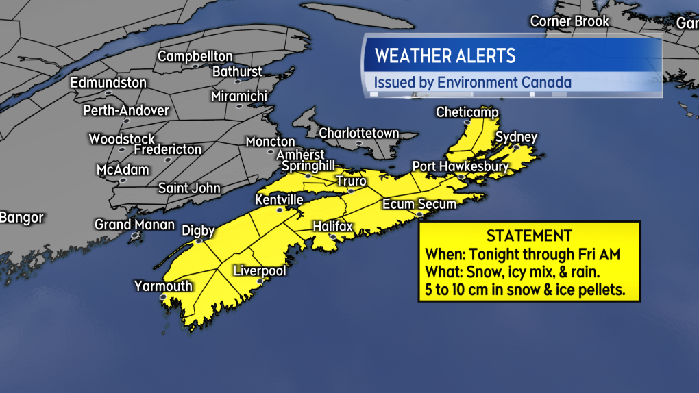 A special weather statement issued by Environment Canada for Nova Scotia calls for some potential accumulation of 5 to 10 cm of snow and ice pellets for parts of the province.
WEDNESDAY NIGHT
A band of snow will arrive in Grand Manan, N.B., and southwestern New Brunswick near and a few hours after midnight. That snow will extend into southwestern Nova Scotia, where it will mix with ice pellets and freezing rain very early Thursday morning.
Some snow and ice accumulation could make for greasy road conditions. By Thursday morning, coastal communities along Nova Scotia’s South Shore should see a turn to rain, but an icy mix will still be present in interior areas.
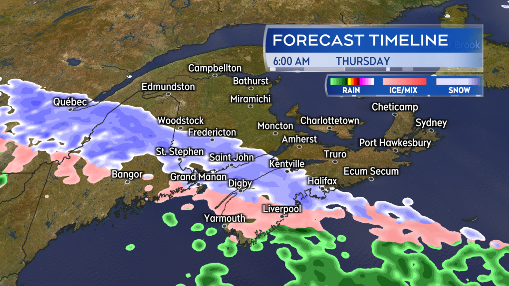 A band of snow, mixed with ice pellets and freezing rain for Nova Scotia, will push into the southwest of the Maritimes Wednesday night into Thursday morning.
THURSDAY MORNING
Motorists in southwestern New Brunswick and western Nova Scotia may experience slick and slower commutes Thursday morning. That includes the Halifax area, which could pick up 5 centimetres of snow and ice pellets early Thursday morning through mid-afternoon before seeing a turn to rain.
While a significant amount of snow isn’t expected, the Halifax Regional Municipality and surrounding areas have yet to contend with several centimetres of a wintry mix yet this season. This is also true for other areas of western Nova Scotia.
Much of the Annapolis Valley and surrounding areas could also pick up amounts approaching 5 centimetres Thursday morning into afternoon. While coastal locations will see a turn to rain by late Thursday afternoon, a light icy mix will linger in interior areas.
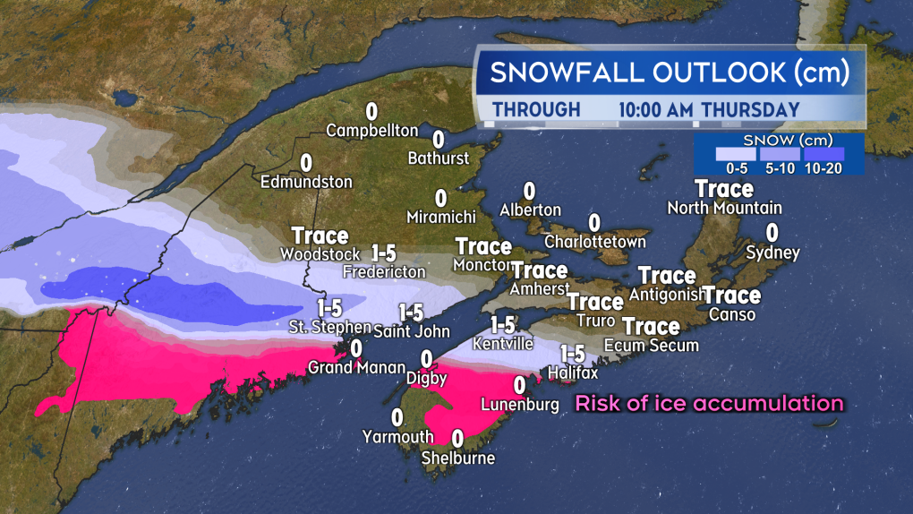 Potential snow accumulation by mid-morning Thursday. Areas in purple are at risk of picking up ice from freezing rain.
THURSDAY NIGHT INTO FRIDAY MORNING
Thursday evening and night will see snow build in eastern New Brunswick, Prince Edward Island, and eastern Nova Scotia.
The additional snow could result in totals between 10 and 15 centimetres by Friday morning in southern New Brunswick. Much of Prince Edward Island will see 5 centimetres of snow by Friday morning, while eastern Nova Scotia and Cape Breton will see a 5-centimetre mix of snow and ice pellets. Eastern parts of the region could see more snow accumulate on Friday.
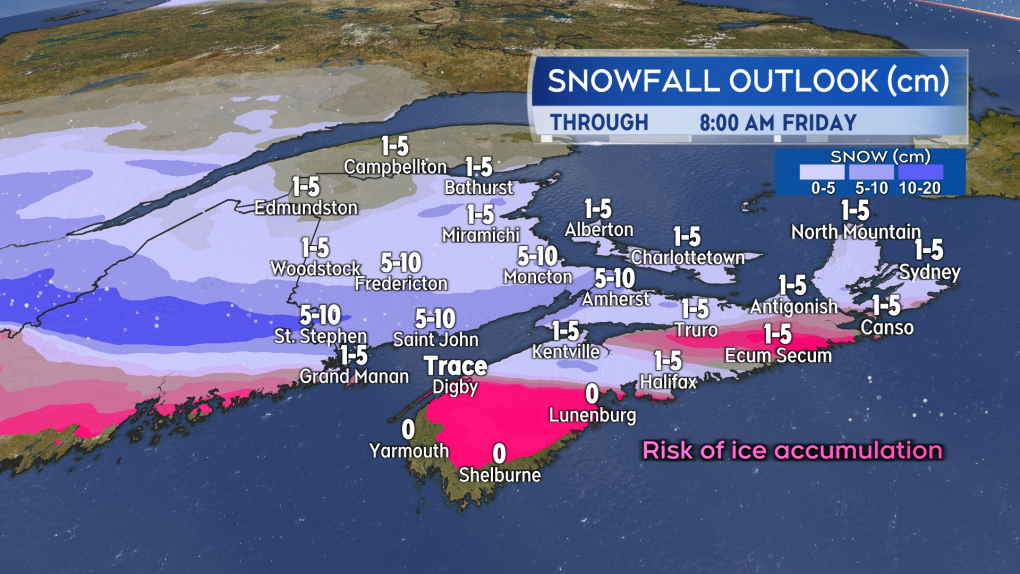 A snowy and icy mix will push further east in the region late Thursday into early Friday. Snow totals for parts of southern New Brunswick could reach 10 to 15 cm.
CTVNews.ca Top Stories

Trump making 'joke' about Canada becoming 51st state is 'reassuring': Ambassador Hillman
Canada’s ambassador to the U.S. insists it’s a good sign U.S. president-elect Donald Trump feels 'comfortable' joking with Canadian officials, including Prime Minister Justin Trudeau.
Mexico president says Canada has a 'very serious' fentanyl problem
Foreign Affairs Minister Mélanie Joly is not escalating a war of words with Mexico, after the Mexican president criticized Canada's culture and its framing of border issues.
Quebec doctors who refuse to stay in public system for 5 years face $200K fine per day
Quebec's health minister has tabled a bill that would force new doctors trained in the province to spend the first five years of their careers working in Quebec's public health network.
Freeland says it was 'right choice' for her not to attend Mar-a-Lago dinner with Trump
Deputy Prime Minister and Finance Minister Chrystia Freeland says it was 'the right choice' for her not to attend the surprise dinner with Prime Minister Justin Trudeau at Mar-a-Lago with U.S. president-elect Donald Trump on Friday night.
'Sleeping with the enemy': Mistrial in B.C. sex assault case over Crown dating paralegal
The B.C. Supreme Court has ordered a new trial for a man convicted of sexual assault after he learned his defence lawyer's paralegal was dating the Crown prosecutor during his trial.
Bad blood? Taylor Swift ticket dispute settled by B.C. tribunal
A B.C. woman and her daughter will be attending one of Taylor Swift's Eras Tour shows in Vancouver – but only after a tribunal intervened and settled a dispute among friends over tickets.
Eminem's mother Debbie Nelson, whose rocky relationship fuelled the rapper's lyrics, dies at age 69
Debbie Nelson, the mother of rapper Eminem whose rocky relationship with her son was known widely through his hit song lyrics, has died. She was 69.
NDP won't support Conservative non-confidence motion that quotes Singh
NDP Leader Jagmeet Singh says he won't play Conservative Leader Pierre Poilievre's games by voting to bring down the government on an upcoming non-confidence motion.
Canadians warned to use caution in South Korea after martial law declared then lifted
Global Affairs Canada is warning Canadians in South Korea to avoid demonstrations and exercise caution after the country's president imposed an hours-long period of martial law.


