Warm summer forecast for much of Canada, but how about the Maritimes?
Environment and Climate Change Canada expects a warmer than average summer for most of Canada.
The weather agency uses the Canadian Seasonal to Inter-annual Prediction System (CanSIPS) to help with longer range outlooks. CanSIPS is based on a collection of 10 forecasts from each of two physical climate computer models that take into account atmospheric, oceanic, and even land conditions.
For the period of July-to-September, the system ranges the Maritime with a 60-to-97 per cent chance of above normal temperatures. Likewise much of the surrounding ocean waters of the Maritimes are given a high probability of being above normal through that time.
No clear trend for precipitation in the Maritimes was indicated by the system. About equal probabilities of finishing July-August-September with either above, near, or below normal amounts of rain.
It is important to note these predictions are for general trends. There will be week-to-week and day-to-day fluctuations in weather conditions. Cooler days, hotter days, damp and dry stretches of weather are all still likely through the summer season.
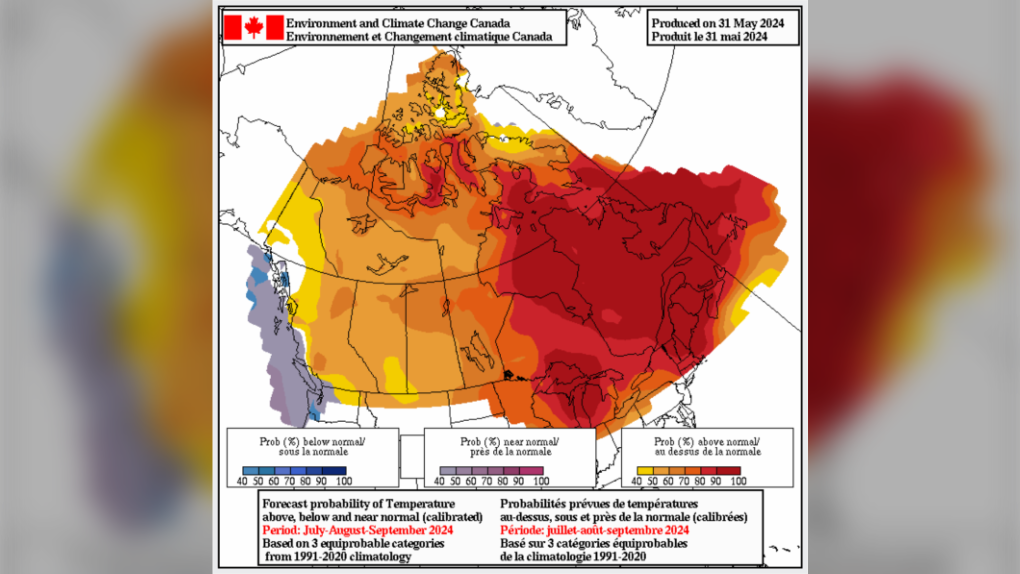 Above normal temperatures predicted by ECCC this summer. For the provincial capitals a 97 per cent chance of being above normal for Fredericton, 89 per cent for Halifax, and 97 per cent for Charlottetown. (Source: CanSIPS)
Second opinion
Other agencies around the world run seasonal prediction models as well. The National Oceanographic and Atmospheric Association (NOAA) of the United States runs seasonal climate forecast model called CFSv2.
Looking at the results from that model for the same period (July-August-September), it also predicts above normal temperatures. In contrast to CanSIPS, it indicates a higher chance of below normal amounts of precipitation, not only for the Maritimes but also the northeastern United States.
A second model run by the NOAA known as North American Multi-Model Ensemble (NMME) predicts above normal temperatures and near normal precipitation.
In summary there is good agreement between multiple systems that July-August-September will be above normal for temperatures in the Maritimes and less agreement as to whether precipitation will be above, near, or below normal.
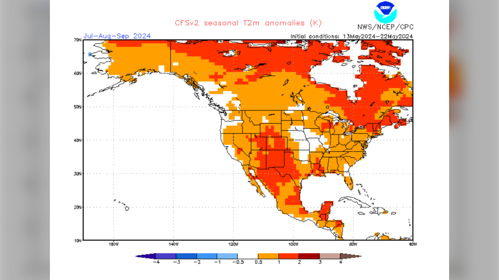 Seasonal guidance from the NOAA also predicts above normal temperatures through summer for the Maritimes. (Source: NOAA)
La Nina and the Atlantic hurricane season
The temperature of surface waters of the southern Pacific continue to transition from El Nino towards a neutral phase. The current forecast favours a transition from neutral to La Nina this summer.
Why does that matter? A La Nina phase in the Pacific favours a wind environment that is more favourable for tropical storm and hurricane development in the Atlantic. This was a primary factor in an active hurricane season forecast for this year.
While we are still waiting for our first named storm of the season, there are now areas being monitored for tropical system development in the southeastern Atlantic and the Gulf of Mexico.
Both regions are being given low chances over two and seven days. During the first part of the hurricane season, the Gulf of Mexico, Caribbean, and southeastern Atlantic are favoured for developing a tropical system. As the season progresses, development of a tropical system in the south-central Atlantic or near the coastline of Africa becomes more likely.
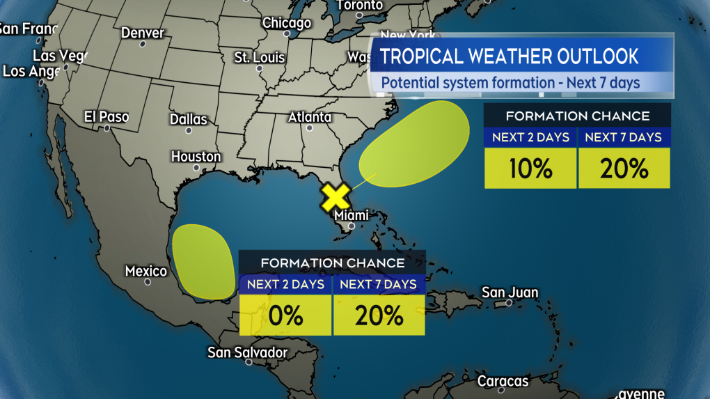 Two areas, both being given a low chance of development, monitored as of Wednesday afternoon by the National Hurricane Center. (Source: CTV News Atlantic)


CTVNews.ca Top Stories

Lawyers looking for thousands of families owed money by Veterans Affairs
The suit was launched after the Office of the Veterans Ombud found the government had been improperly calculating the disability benefits and pensions of its clients starting in 2003.
BREAKING
BREAKING House explodes in Transcona; Winnipeg firefighters responding
The City of Winnipeg is asking people to avoid the area of Camrose Bay after a house exploded.
'Why did I have this surgery?' Ont. mother seeks answers after son's tonsil surgery
An Ontario mother said it looked like a horror movie when she flicked on the lights of her son’s bedroom to find him projectile vomiting blood after his tonsils were removed at McMaster Children’s Hospital.
It's one month until the Paris Olympics -- is the city ready for it? A historian weighs in
With just one month until the 2024 Olympics take over Paris, is the city ready for it? Some have noted concerns ahead of the Games, which begin on July 26, including the possibilities of crowding, extreme heat and a pollution problem.
'Deeply unserious': Vancouver councillor claims mayor turned city hall boardroom into gym
A Vancouver city councillor is calling out Mayor Ken Sim for apparently limiting access to a city hall boardroom and turning it into a makeshift gym.
Trudeau's cabinet all ears to the concerns of Canadians as political fortunes fall
Several federal cabinet ministers say they are all ears to what disgruntled voters are saying in the aftermath of a Toronto byelection defeat in what was considered a safe Liberal riding.
Sask. Party catches heat after using Russian filmed stock footage in campaign ad
The Saskatchewan Party is facing criticism for a pre-election campaign ad. It featured video portraying Saskatchewan's scenery but contained some footage actually filmed in Russia.
U.S. charges 5, including man acquitted at trial, for attempting to bribe Minnesota juror with US$120K
Five people were charged on Wednesday for trying to bribe a juror in one of the country’s largest pandemic aid fraud cases with a bag of US$120,000 in cash, the U.S. Attorney's Office and the FBI announced Wednesday.
Things a pediatrician would never let their child do
As summer begins for most children around Canada, CTV News spoke with a number of pediatric health professionals about the best practices for raising kids, and how the profession has evolved since the COVID-19 pandemic.
Shopping Trends
The Shopping Trends team is independent of the journalists at CTV News. We may earn a commission when you use our links to shop. Read about us.


Toronto
-
 BREAKING
BREAKING 'Disturbing incident': Toronto police identify suspect who allegedly concealed dead body in Riverside apartment
Toronto police say a convicted sex offender wanted on a Canada-wide warrant befriended a “vulnerable individual” and concealed their dead body in a Riverside apartment last month.
-
'Why did I have this surgery?' Ont. mother seeks answers after son's tonsil surgery
An Ontario mother said it looked like a horror movie when she flicked on the lights of her son’s bedroom to find him projectile vomiting blood after his tonsils were removed at McMaster Children’s Hospital.
-
Automatic Ontario licence plate renewals start Canada Day
Ontario drivers in good standing won’t have to worry about renewing their licence plates starting Canada Day.
Calgary
-

Charges laid in violent Calgary kidnapping that saw victim restrained, assaulted
Calgary police have laid charges in a horrific and violent kidnapping last month.
-
Test water flowing through repaired Calgary pipe, full service days away
Water is flowing again in a massive Calgary pipe — test water. Calgary Mayor Jyoti Gondek says work has started to fill the repaired pipe with water for testing.
-
Accused at Coutts murder-conspiracy trial said he feared attack by Chinese communists
A man accused of conspiring to kill Mounties at the Coutts border blockade says he was fighting a larger battle against tyranny and potential foes like Chinese communists.
Edmonton
-

Police investigating at 82 Avenue apartment building
Police taped off the entrance to an apartment building east of Whyte Avenue early Wednesday morning.
-
Smith tells Trudeau Alberta will opt out of federal dental plan
Alberta is opting out of the federal dental plan, the premier told the Canadian government late Tuesday afternoon.
-
Convicted sexual offender to live in Edmonton, police warn
Edmonton police are warning the public about the release of a convicted sexual offender into the city who they believe could offend again.
Montreal
-

Montreal peregrine falcon chicks take first flights into a world full of danger
This week, three falcon chicks named Hugo, Polo and Estebane started to spread their wings around the nest site on the 23rd floor of the Universite de Montreal tower, with hundreds of online viewers watching their every move.
-
Companies face confusion as they prepare for Quebec's new language rules next year
In just under a year's time, important pieces of the new French language law are set to come into force for companies operating in Quebec. Although many are preparing for the laws to be applied, the future requirements are still causing some stress, notably because of the paperwork involved and what some say is a lack of clarity.
-
Newly revived Just For Laughs festival announces its program in Montreal
Montreal's Just For Laughs festival relaunched this summer with a scaled-down program featuring shows by Dane Cook, Bassem Youssef and Bobby Slayton.
Ottawa
-

Man facing charges for allegedly threatening Ottawa Coun. Plante, police say
An Ottawa man is facing charges of uttering threats and harassment after allegedly making threats towards Ottawa-Vanier Coun. Stephanie Plante.
-
Ottawa Train Yards placed in receivership over owner's unpaid $39 million loan
One of Ottawa's largest shopping centres has been placed in receivership over an outstanding $39 million loan by the owner of the property. The Ontario Superior Court of Justice appointed Grant Thornton Limited as receiver and manager of the assets of Ottawa Train Yards on Industrial Avenue.
-
Ottawa police renew calls for tips in 2017 murder outside Rideau Street nightclub
Ottawa police are renewing calls in the unsolved murder of a 27-year-old man who was murdered outside a Rideau Street nightclub seven years ago.
London
-

Tornado warning in effect for the region
Environment Canada meteorologists are tracking a severe thunderstorm that is possibly producing a tornado. Damaging winds, large hail and locally intense rainfall are also possible. This is a dangerous and potentially life-threatening situation.
-
Cleanup underway after windy afternoon in London
Cleanup is underway around the city after a storm blew through the region on Tuesday afternoon. The areas in London hit hardest were north east London and Old North.
-
City of London and CUPE Local 107 reach new labour agreement, with increases until 2027
The City of London has reached a new collective agreement with CUPE Local 107 – a labour union which represents the city’s outside workers. “This agreement reflects the hard work, respectful dialogue and commitment demonstrated by both sides of the bargaining table,” said City Manager, Sandra Datars Bere.
Barrie
-

Barrie police seek suspects in break-in & theft from Anne Street business
Police are looking for two suspects accused of stealing roughly $1,000 worth of items after breaking into a Barrie business.
-
Suspects impersonating police officers make traffic stop in New Tecumseth
Provincial police in New Tecumseth are investigating and warning the public after a report of two men posing as officers who conducted a traffic stop.
-
Barrie police officer makes court appearance for 2nd discreditable conduct charge
A high-ranking Barrie Police Service officer facing a second count of discreditable conduct made her first appearance in a virtual Police Services Act hearing Wednesday morning.
Northern Ontario
-

One of Canada's most popular vehicles recalled over transmission issue; 95,000 impacted
One of the country's most popular vehicles is being recalled in Canada due to a transmission issue that may impact tens of thousands of drivers.
-
Fuel, motor oil cleanup continues on Hwy. 144 after crash near Gogama
The ministry of environment says cleanup is continuing after a crash on Highway 144 last week near Gogama resulted in the spill of motor oil and diesel fuel.
-
Things a pediatrician would never let their child do
As summer begins for most children around Canada, CTV News spoke with a number of pediatric health professionals about the best practices for raising kids, and how the profession has evolved since the COVID-19 pandemic.
Kitchener
-

Waterloo resident dies in crash near Milverton, Ont.
A Waterloo resident has died following a Tuesday night crash north of Milverton, Ont.
-
OPP release names in death investigation in Harrow
Essex County OPP have released the names of four family members in an ongoing death investigation in Harrow.
-
University of Waterloo takes legal action to remove Occupy UW encampment
An ongoing dispute between the University of Waterloo and a pro-Palestinian encampment has turned into a legal battle.
Windsor
-

E.C. Row Expressway ramp at Dougall Avenue closed after truck rollover
Windsor police have closed the E.C. Row Expressway westbound off ramp at Dougall Avenue.
-
OPP release names in death investigation in Harrow
Essex County OPP have released the names of four family members in an ongoing death investigation in Harrow.
-
School board meeting shut down, police called over disruptions
A special meeting of the Greater Essex County District School Board (GECDSB) was dissolved after numerous disruptions from members of the public.
Winnipeg
-
 BREAKING
BREAKING House explodes in Transcona; Winnipeg firefighters responding
The City of Winnipeg is asking people to avoid the area of Camrose Bay after a house exploded.
-
No charges for driver in 2023 Manitoba bus crash that killed 17 seniors: RCMP
Manitoba RCMP and Crown prosecutors will not lay charges against the driver of a bus involved in a crash with a semi-truck in 2023.
-
Winnipeg firefighters rescue two trapped inside apartment during fire
A Wednesday morning fire at an apartment building in Winnipeg has sent two people to the hospital.
Regina
-

Walk of Fame inductee Tatiana Maslany celebrated in 'Hometown Stars' event
Award winning actor Tatiana Maslany is set to be honoured today at a special Canada's Walk of Fame 'Hometown Stars' event in Regina.
-
Sask. Party catches heat after using Russian filmed stock footage in campaign ad
The Saskatchewan Party is facing criticism for a pre-election campaign ad. It featured video portraying Saskatchewan's scenery but contained some footage actually filmed in Russia.
-
Revival for Regina baseball stadium proposal possible
A motion headed before Regina city council could bring the possibility of a new baseball facility in Regina back up to the plate.
Saskatoon
-

'The federal government can't interfere': Sask. will not comply with federal clean electricity regulations
The Government of Saskatchewan announced that it will not comply with the incoming federal clean electricity regulations.
-
'Scenic route' into Sask. national park closed due to road damage
Drivers looking to take the “scenic route” into the Prince Albert National Park will need to take a detour for now.
-
Judge rejects Saskatoon mayoral candidate's lawsuit to halt housing accelerator changes
A judge has rejected a Saskatoon mayoral candidate’s bid for a court injunction on zoning changes required for the city to access federal housing accelerator funds.
Vancouver
-

Video of suspect in synagogue arson released by Vancouver police
Vancouver police have released video of a suspect they believe set fire to the entrance of a synagogue last month.
-
B.C. coroner says 11 people died of heat injuries in 2023, urges residents to prepare
Eleven people died from suspected heat-related injuries in British Columbia last year, according to the latest data from the provincial coroners service, which is urging residents to prepare for more unusually high temperatures this summer.
-
'Deeply unserious': Vancouver councillor claims mayor turned city hall boardroom into gym
A Vancouver city councillor is calling out Mayor Ken Sim for apparently limiting access to a city hall boardroom and turning it into a makeshift gym.
Vancouver Island
-

B.C. coroner says 11 people died of heat injuries in 2023, urges residents to prepare
Eleven people died from suspected heat-related injuries in British Columbia last year, according to the latest data from the provincial coroners service, which is urging residents to prepare for more unusually high temperatures this summer.
-
Meet the centenarians: Canada's oldest age group is also its fastest-growing
Vi Roden said she reads an average of 50 books a year, attends history lectures at her local seniors centre, and does yoga twice a week.
-
Critically endangered Vancouver Island marmots released into the wild
Volunteers carried cages containing very rare furry creatures up Mount Washington on Monday as part of the mission to save Canada’s most endangered mammal.
Kelowna
-

Man stabbed in Kelowna, suspect at large: RCMP
Mounties in Kelowna say a suspect is at large after a man was stabbed in the city Sunday afternoon.
-
Police still investigating cause after woman found dead in Kelowna park
Police are remaining tight-lipped about a woman’s death in a Kelowna park on Friday.
-
Man shot dead in Princeton, B.C., was high-ranking gang member, court records suggest
Police have identified a man found dead in B.C.’s Interior last weekend as Donald “Donnie” Lyons.


