Warmer, muggy Wednesday followed by rainy Thursday
With a mix of sun and cloud and a southwest wind, temperatures in the Maritimes took a step up on Wednesday. Afternoon highs are expected in the range of 24 to 28 C and in some cases it feels closer to 30 C with the humidex. The southwest wind is more directly onshore for the Bay of Fundy coastline in New Brunswick and the Atlantic coastline of Nova Scotia. Coastal communities in those areas could be held with highs in the range of 18 to 22 C.
Spotty showers and thunderstorms will pop-up in New Brunswick Wednesday afternoon through early evening, 2 p.m. to 8 p.m. There is a chance a few could reach western Prince Edward Island as well. The primary hazard would be lightning. Moving later into the evening, any developed showers or thunderstorms will dissipate.
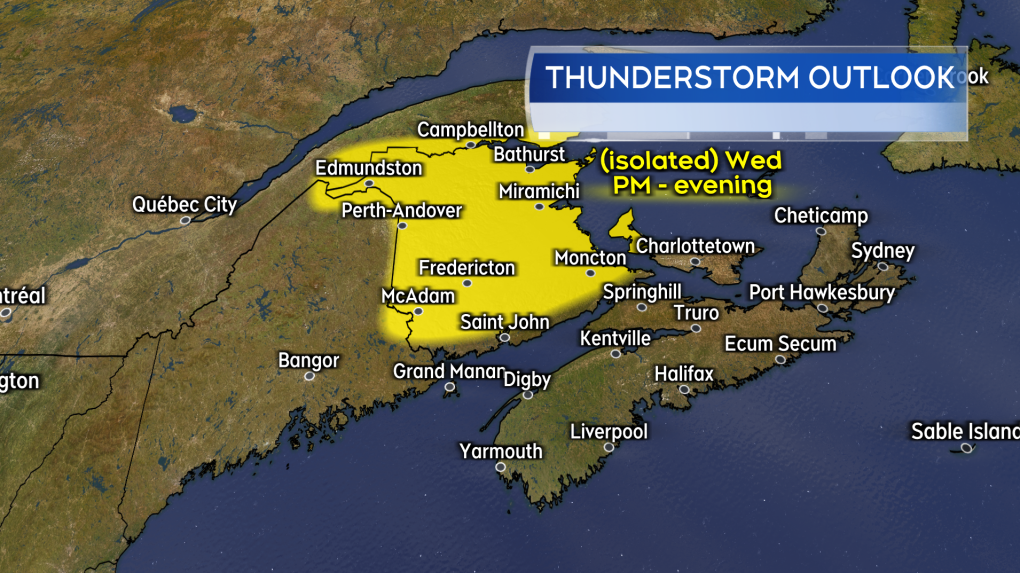 Pop-up showers and thunderstorms possible in New Brunswick and western P.E.I. Wednesday afternoon into early evening. (Source: CTV News Atlantic)
Rainy Thursday
A low-pressure system crosses the Maritimes on Thursday. Rain, showers, and fog will be widespread for the region and there will be a risk of embedded thunderstorms within the rain.
General rain amounts of 10-to-30 mm can be expected. Should a thunderstorm move directly over, it could bump localized rain amounts into a range of 30-to-50 mm. Lower rain totals of two-to-10 mm in eastern areas of Nova Scotia.
A gusty southwest wind will accompany the wet weather for Nova Scotia and Prince Edward Island. For those provinces, peak gusts could reach 40-to-60 km/h. There could b gusts of 20-to-40 km/h for New Brunswick.
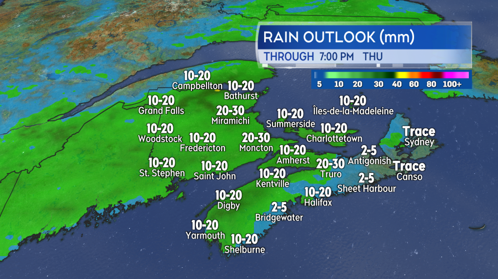 Soggy and foggy weather returns for Thursday. (Source: CTV News Atlantic)
Canada Day long weekend update
There will be a mix of sun and cloud along with isolated showers in the Maritimes on Friday. There will be a fresher feel to the air as less humid air moves in. High temperatures are expected in the low 20s.
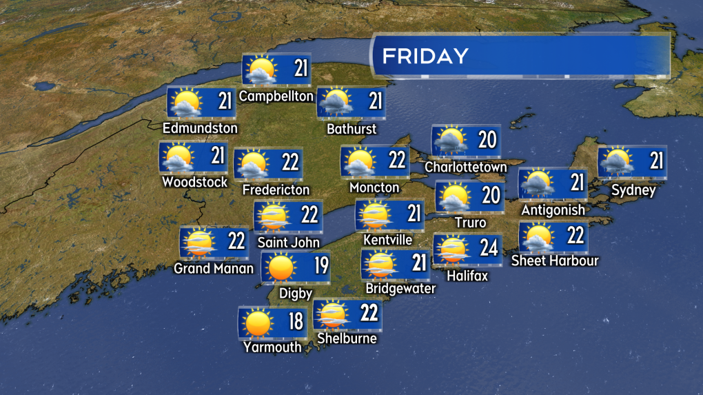 A mostly pleasant Friday. Isolated showers for southeastern New Brunswick, Prince Edward Island, and northern/eastern Nova Scotia. (Source: CTV News Atlantic)
There will be increasing cloudiness through the day on Saturday. Showers will reach New Brunswick Saturday evening and night. High temperatures are expected in the low-to-mid 20s.
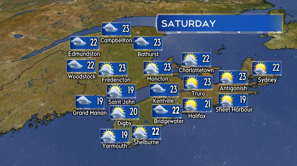 Increasing cloudiness on Saturday. Rain and showers return for the Maritimes on Sunday. (Source: CTV News Atlantic)
Sunday is wet as another weather front crosses the Maritimes. There will be periods of rain and showers. Canada Day weather still depends on how quickly the Sunday front moves through. As it stands, there is still a chance it stalls near the Atlantic coastline of Nova Scotia, keeping a possibility of rain in the forecast for that province. There is a chance of showers for eastern Prince Edward Island and New Brunswick should clear to a mix of sun and cloud.


CTVNews.ca Top Stories

Killer who stabbed victim 'at least 52 times' dies in B.C. prison
A 72-year-old inmate serving a life sentence for a brutal murder that happened in Chilliwack in 2016 has died, according to the Correctional Service of Canada.
Israeli airstrikes hit the southern suburbs of Beirut after another strike destroyed buildings
The Israeli military said it struck Hezbollah's headquarters in Beirut on Friday in a series of massive explosions that targeted the leader of the militant group and levelled multiple high-rise apartment buildings.
American woman gets SUV stuck in elevator bay at B.C. casino
A U.S. driver somehow squeezed her vehicle through a parkade hallway at a Metro Vancouver casino Thursday, before getting stuck at an elevator bank.
Hurricane Helene kills at least 44 and cuts a swath of destruction across the Southeast
Hurricane Helene left an enormous path of destruction across Florida and the southeastern U.S. on Friday, killing at least 44 people, snapping towering oaks like twigs and tearing apart homes as rescue crews launched desperate missions to save people from floodwaters.
After decades-long search, northern Ontario man finds vintage vehicle in Larder Lake
A tale about a taxicab hauling gold and sinking through the ice on Larder Lake, Ont., in December 1937 has captivated a man from that town for decades.
2 people caught illegally crossing the International Railroad Bridge into the U.S.: border officials
Two Italian citizens have been apprehended after allegedly illegally crossing over the International Railroad Bridge to the United States.
Former military reservist sentenced for shotgun video calling Liberal MP a 'communist agent' for China
A former Canadian military reservist has been sentenced to house arrest after posting a video of himself firing a shotgun at a picture of a member of Parliament whom he accused of being a 'communist agent' for China.
P.E.I. shellfish festival gastrointestinal illness outbreak largest in province's history: health officer
More than 550 symptomatic people responded to an online questionnaire about a gastrointestinal illness at a Prince Edward Island shellfish festival last weekend.
Family of man who died in incident involving Calgary police issues statement
The family of Jon Wells, a man who died in an incident involving Calgary police earlier this month, say they are seeking time to grieve their loss.
Shopping Trends
The Shopping Trends team is independent of the journalists at CTV News. We may earn a commission when you use our links to shop. Read about us.


Toronto
-

Police receive more reports of rocks being thrown at moving vehicles in Markham
Ontario Provincial Police say they have learned about more incidents of rocks being thrown at vehicles on Highway 48 in Markham.
-
17-year-old boy arrested, 3 others sought in connection with alleged gang sex assault in St. Catharines
A 17-year-old boy has been arrested and three more suspects are being sought in connection with an alleged gang sexual assault of a woman in St. Catharines earlier this month, which police believe was a 'targeted' incident.
-
2 people caught illegally crossing the International Railroad Bridge into the U.S.: border officials
Two Italian citizens have been apprehended after allegedly illegally crossing over the International Railroad Bridge to the United States.
Calgary
-

Family of man who died in incident involving Calgary police issues statement
The family of Jon Wells, a man who died in an incident involving Calgary police earlier this month, say they are seeking time to grieve their loss.
-
Promising momentum for Calgary's Green Line LRT project
The Green Line LRT project seemed to stall in September but many say it hasn't gone off the rails, as Calgary's mayor and the province met again to discuss options on Friday.
-
'I want to leave but I'm scared': Calgarian and her kids stuck in Lebanon as conflict rages on
Safaa went to Lebanon looking to meet with a specialist for her Crohn's disease. Now, she and her four children are caught in the conflict between Israel and the militant group Hezbollah.
Edmonton
-

Expect familiar, veteran lineups over second half of Oilers' pre-season schedule
There's one more week of pre-season games for the Edmonton Oilers before the National Hockey League team sets its roster for opening night a few days later.
-
Edmonton, other municipalities ask province to pay its property taxes
Edmonton's mayor is, once again, asking the United Conservative Party government to pay its full share of property taxes on provincial buildings.
-
No increase in lithium-ion battery fires in Edmonton, officials still encourage caution
Edmonton Fire Rescue Services (EFRS) says it hasn't seen a rise in fires related to lithium-ion batteries, but is still encouraging Edmontonians not to overcharge their devices.
Montreal
-

Woman found dead in Hemmingford, Que. after going missing; man, 31, charged
A 31-year-old man has been charged following the death of a woman who went missing in southern Quebec earlier this week.
-
Montreal police make arrest in Presidents Cup golf apparel theft
Montreal police say they've arrested a man in connection with the theft of tens of thousands of dollars in golf merchandise tied to the Presidents Cup PGA Tour being held this week in the city.
-
CTV News Montreal at Six for Friday, Sept. 27, 2024
CTV News Montreal at Six for Friday, Sept. 27, 2024 with anchor Mutsumi Takahashi.
Ottawa
-

Rats are overtaking Overbrook
A rat infestation in Overbrook is causing a major headache for residents, who say the problem is out of control. Rats can be seen in yards day and night, with no sign of relief.
-
Ottawa Hospital parking rates set to increase starting Tuesday
Parking rates at The Ottawa Hospital (TOH) will increase as of Tuesday for patients, visitors and staff.
-
'It sounded like a tornado': Former Ottawa resident describes Hurricane Helene making landfall
When Hurricane Helene roared ashore in Florida as a Category 4 storm on Thursday, former Ottawa resident Judy Brown felt its wrath.
London
-

London man charged with attack on Muslim women
The National Council of Canadian Muslims and Hikma Public Affairs Council have both released statements on social media regarding the reported incident.
-
Knights fall in home opener against the Firebirds
The London Knights kicked off the new hockey season tonight at Budweiser Gardens against the Flint Firebirds
-
Risky maneuver by City of London garbage truck driver raises serious safety concerns
An early morning collision in south London is raising questions about the actions of a garbage truck driver who accelerated in reverse — slamming into Rebekkah Wilkin’s car.
Barrie
-

Police swarm home after man allegedly confronts snowmobile owner with crossbow
Several heavily armed officers descended on a home in the southeast area of Barrie Thursday afternoon after reports of a man armed with a crossbow.
-
Multi-vehicle crash on Highway 400 sends one to hospital
A multi-vehicle collision on Highway 400 in Bradford caused some traffic backups ahead of the weekend.
-
Weekend work along busy Barrie road means lane closures, restrictions
Motorists planning to drive near the intersection of Essa Road and Anne Street South in Barrie over the weekend may have to pack their patience.
Northern Ontario
-

After decades-long search, northern Ontario man finds vintage vehicle in Larder Lake
A tale about a taxicab hauling gold and sinking through the ice on Larder Lake, Ont., in December 1937 has captivated a man from that town for decades.
-
Complainant breaks down as cross-examination resumes in Hoggard sexual assault trial
The emotional cross-examination of the woman accusing Jacob Hoggard of sexual assault continued at his trial Friday, as the Canadian musician's defence lawyer sought to highlight possible issues with the complainant's memory.
-
Doorbell camera captures tense bear showdown at B.C. family's front door
There were some tense moments for a B.C. family this week after their dog came face-to-face with a protective mama bear right outside their front door.
Kitchener
-

Preparations underway for a busy homecoming weekend
It’s homecoming weekend for many students and alumni and preparations are underway to ensure it’s a safe celebratory weekend.
-
What is Ontario's homeworkers' minimum wage, and why is it higher than general minimum wage?
When Ontario’s minimum wage goes up on Oct. 1, another group of workers will also see an increase. But what is the homeworkers’ minimum wage?
-
What to expect as Kitchener-Waterloo Oktoberfest kicks off
It’s the first weekend for the big Bavarian bash in Waterloo Region and it’s starting with a bang.
Windsor
-

Canada and Ontario investing $1.5 million in support of international agri-food workers
The federal and provincial governments are committing up to $1.5 million over the next four years to improve support for international agri-food workers (IAWs) in Ontario.
-
New battery storage project coming to Tilbury
The Ontario government unveiled a new battery storage project in Tilbury that aims to provide reliable and affordable clean energy to families and businesses.
-
More than $100,000 donated to Brentwood Recovery Home on 60th anniversary
Over $100,000 has been donated to Brentwood Recovery Home on its 60th anniversary from St. Clair College and Windsor Rona+ stores.
Winnipeg
-

Manitoba signs off on sale of Portage Place
The Province of Manitoba has signed off on the sale of Portage Place, finalizing a deal with all three levels of government for True North to purchase the mall.
-
Winnipeg high school students leading TRC learning
This is the first year Technical Vocational High School had an Orange Shirt Day walk.
-
Ontario woman arrested in Sask. following alleged child abduction: Manitoba RCMP
An Ontario woman who allegedly abducted her three children from Ontario and crossed into Manitoba was arrested in Saskatchewan this week.
Regina
-

Sask. man dies in Highway 1 collision just east of Regina
A man from Weyburn, Sask. died following a collision on Highway 1 just east of Regina on Friday morning.
-
Eight anomalies found in George Gordon First Nation’s search of unmarked graves
George Gordon First Nation has completed their second phase in search of unmarked graves.
-
Kahkewistahaw First Nation celebrates new detox centre
Members of Yorkton Tribal Council (YTC) are taking action to address the growing addictions crisis through the grand opening of their new detox centre – Eagle Sky Healing Lodge Detox Centre.
Saskatoon
-

Saskatoon's homeless population nearly doubled this year
Saskatoon's homeless population is on pace to more than double in one year, according to data from the Saskatoon Fire Department.
-
'This was her life': Owner of Sask. restaurant destroyed in fire plans to restart
In the aftermath of a fire that destroyed Snow White Family Restaurant in Biggar Saskatchewan, a GoFundMe has been created to help the owner start over.
-
EXCLUSIVE
EXCLUSIVE New poll reveals some key issues for voters in upcoming Sask. election
The most important issues for Saskatchewan voters depends on which party they support, according to a new poll.
Vancouver
-

Free market and rebates: BC Conservatives lay out housing platform
The leader of the BC Conservative Party laid out his strategy to solve the province's housing crisis Friday, which includes slashing red tape and letting the private sector take the reins on boosting supply.
-
Squamish Nation hosts truth and reconciliation ceremony at Sen̓áḵw
More than 100 years after they were forced from the Sen̓áḵw village, members of the Squamish Nation will soon once again call it home.
-
Man shot dead in Langley was suspect in Mission road rage assault: RCMP
The man who was killed in a shooting believed to be gang-related in Langley last week was also a suspect in a brutal road rage assault on a couple in Mission earlier this month, police have confirmed.
Vancouver Island
-

'It's a dream come true': B.C. composer living with debilitating condition earns red carpet recognition
Ari Kinarthy never imagined he'd become the focus of photographers on a red carpet, back when he was a boy fighting to have fun.
-
B.C. Conservatives, NDP have full candidate slates. But it's about more than votes
In the last provincial election, the B.C. Conservatives fielded just 19 candidates — and received less than 2 per cent of the vote.
-
Vancouver police officer charged in 2023 pedestrian crash
The BC Prosecution Service says it has approved a charge against a Vancouver police officer over a collision with a pedestrian in 2023.
Kelowna
-

'Don't know where the animals came from': Runaway pigs rounded up in West Kelowna, B.C.
A pair of runaway pigs are in the custody of an animal sanctuary in the Okanagan after evading police and volunteers for hours earlier this week.
-
Video shows historic bridge in Kamloops, B.C., collapsing after fire
The Red Bridge, a historic landmark in Kamloops, B.C., was completely destroyed by fire early Thursday morning.
-
Pregnant pit bull with 10 puppies rescued from rat-infested B.C. home
Animal protection officers in British Columbia have rescued three pit bulls – including one that gave birth to 10 puppies – from a rat-infested home in Kelowna.


