Weather system stretching from Gulf States to Atlantic Canada continues risk of thunderstorms
A weather system extending from the Gulf States, up the eastern United States seaboard, and across Atlantic Canada continues to bring periods of showery weather along with a risk of thunderstorms.
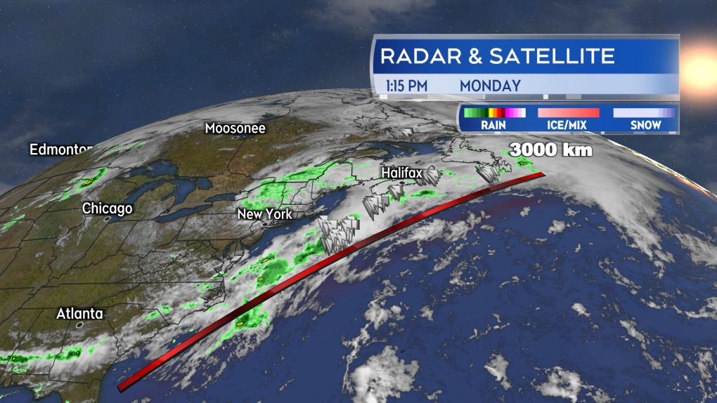 The weather front extends well over 3,000 kilometres in length and is acting like a conveyor belt bringing rounds of showers and thunderstorms up from the subtropical Atlantic.
For Monday afternoon and evening, the chance of thunderstorms is highest in southern New Brunswick and near the Atlantic coastline of Nova Scotia. It is possible that the thunderstorms near the Atlantic coastline of Nova Scotia could hold mostly offshore.
Another round of rain arrives for Nova Scotia late Monday night into Tuesday morning. There is a chance of embedded thunderstorms with that as well. The risk of thunderstorms start around 10 p.m. to midnight near the Atlantic coastline of the mainland. Both eastern Nova Scotia and the southwest of the province with a risk of thunderstorms extending into Tuesday morning.
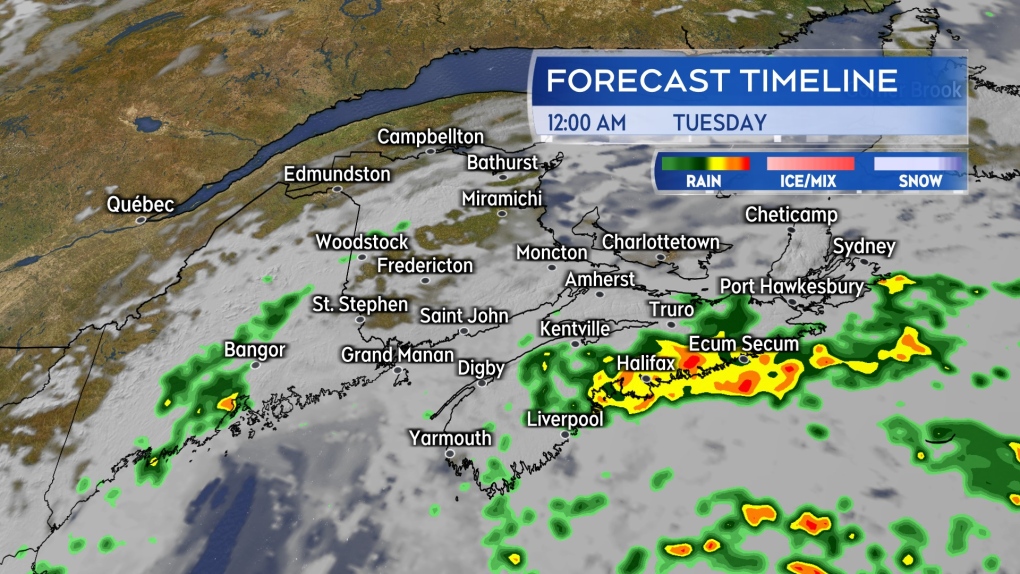 Another round of rain is expected to arrive for Atlantic coastal Nova Scotia late Monday night, bringing a further risk of thunderstorms with it.
The weather front is tapping into moisture from the subtropical Atlantic. Downpours producing localized rain totals 50-plus mm are possible with occurring thunderstorms. That increases the chance of hazards such as reduced visibility on roads in the heavier rain, hydroplaning conditions, and localized flooding.
Weather front clears
While slow moving, the area of low pressure and associated weather front is expected to clear the Maritimes on Tuesday. A low chance of showers in southeastern New Brunswick and Prince Edward Island could be possible on Tuesday. Showers are forecast to end in Nova Scotia Tuesday afternoon and early evening.
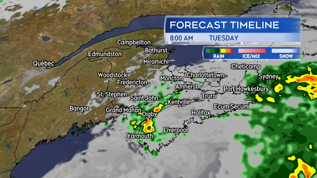 Showers with a risk of thunderstorms in eastern and southwestern Nova Scotia Tuesday morning. Remaining showers ending in the region Tuesday afternoon and evening.
A similar weather arrives for the Maritimes on Thursday with rain and showers once again becoming more widespread. A risk of thunderstorms within the rain is also possible. Rain totals are coming in lower for the Thursday wet weather, with a general range of 5 to 20 mm. However, any occurring thunderstorms could produce higher local amounts.
Weekend rain report
Rain reports over the weekend into Monday morning are highly varied across the Maritimes. Not unusual, given the pockets of downpours and thunderstorms.
Northern and central areas of New Brunswick, as well as western Prince Edward Island, are reporting the most widespread rain totals of more than 30 mm. This report does not include the additional rain expected in the form of showers and thunderstorms Monday afternoon through Tuesday morning.
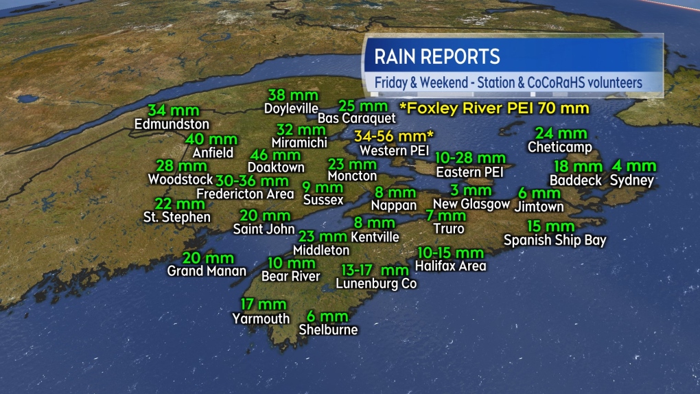 Weekend into Monday morning rain reports. These do not include the additional rain expected from further showers and thunderstorms Monday afternoon through Tuesday morning.


CTVNews.ca Top Stories

Watch Live Now: Canadian analysis ahead of the CNN Presidential Debate
U.S. President Joe Biden and former president Donald Trump are set to go head-to-head tonight in the first of two planned presidential debates. Here's how to watch the CNN Presidential Debate, Power Play's pre- and post-debate specials, and follow along in our real-time CTVNews.ca live expert analysis and commentary by debate and body-language experts.
'Hanging on for her life': Sask. family desperate to bring home sick niece from Philippines
For half a decade, a Saskatoon family has been trying to bring their orphaned niece to Canada, they say now it’s a matter of life or death.
'No additional flights will be cancelled': WestJet avoids strike as feds order binding arbitration
A potential strike by WestJet airplane mechanics would upend travel plans for 250,000 customers over the Canada Day long weekend, the airline says — and cost it millions of dollars.
BREAKING
BREAKING Nunavut judge sentences Toronto woman to 3 years prison for Inuit identity fraud
A Nunavut judge has sentenced a Toronto woman to three years in prison in a case of Inuit identity fraud.
Canada's top court rejects appeal from Sask. man who murdered wife
The Supreme Court of Canada has rejected an application from a Saskatoon man who murdered his wife.
Where do new Canadians come from? India and Philippines take top spots
Canada has welcomed more than 3.9 million new citizens since 2005, with nearly one third coming from India, the Philippines or China, according to a CTVNews.ca analysis.
Marilyn Monroe's former Los Angeles home declared a historic monument to save it from demolition
Fans of Marilyn Monroe have won a battle to preserve her mark on Los Angeles and are a step closer to seeing a towering statue of the silver screen icon remain in Palm Springs.
Man charged with threatening to kill presidential candidates found dead as jury was deciding verdict
A New Hampshire man charged with threatening the lives of presidential candidates last year has been found dead while a jury was deciding his verdict, according to court filings Thursday.
AI regulation 'a start,' needs to 'have teeth': Hinton, godfather of AI, says
So-called godfather of AI Geoffrey Hinton says he's 'pleased' governments are starting to take artificial intelligence, and the possible regulations of it, seriously.
Shopping Trends
The Shopping Trends team is independent of the journalists at CTV News. We may earn a commission when you use our links to shop. Read about us.


Toronto
-

LCBO to close all retail stores for 14 days if strike not averted
With a week left until thousands of LCBO workers could walk off the job, the Crown corporation has announced that it will close all its retail stores for 14 days if no deal is reached by July 5.
-
What is anaplasmosis? A tick-borne disease with confirmed cases in Ontario
Ontarians heading outdoors this summer are likely well-versed on the potential risk of Lyme disease that comes with a tick bite. But there are three other pathogens that can be transmitted by blacklegged ticks that public health officials want you to know about – and confirmed cases have already been reported in Ontario.
-
Analysis of the CNN Presidential Debate between Joe Biden and Donald Trump
U.S. President Joe Biden and former president Donald Trump went head-to-head in the first of two planned presidential debates.
Calgary
-

'No additional flights will be cancelled': WestJet avoids strike as feds order binding arbitration
A potential strike by WestJet airplane mechanics would upend travel plans for 250,000 customers over the Canada Day long weekend, the airline says — and cost it millions of dollars.
-
UCP blasts new NDP leader Nenshi with attack ads; Smith says he has no policy
The UCP has come out swinging at new Alberta NDP leader Naheed Nenshi in a series of attack ads.
-
Federal health minister accuses Alberta premier of putting politics over patients in dental-care debate
Two days after Alberta informed Ottawa the province intends to "opt out" of a national dental-care program, the federal health minister says Danielle Smith is "trying to seek conflict" instead of focusing on patients.
Edmonton
-

Holland leaves Oilers; CEO searching for new GM before starting negotiations with Draisaitl
Ken Holland is out as Edmonton Oilers president of hockey operations and general manager. He joined the Oilers in May 2019 and his contract ends this Sunday.
-
Alberta police watchdog clears pair of city officers in man's 2020 shooting death
Police officers involved in a man's September 2020 Edmonton shooting death have been cleared by the province's law-enforcement watchdog.
-
3 charged in Alta. auto theft ring connected to organized crime
Several stolen vehicles believed to have been used in organized and serious crime, including one homicide, have been found in Alberta during an investigation into an auto theft ring.
Montreal
-

Woman killed after tree falls on her in Mont-Saint-Bruno park
The pond sector at the Mont-Saint-Bruno Provincial Park is closed after a woman died after a tree fell on her on the Grand-Duc trail on Thursday.
-
350 concerts coming as Montreal Jazz Fest kicks off
The stage is set for the 44th edition of the Montreal International Jazz Festival. Over the next 10 days there will be 350 concerts taking place in the heart of downtown, the majority of them free.
-
River shuttle collides with boat, injuring 9 on Montreal's South Shore: police
Nine people have suffered minor injuries after an STM river shuttle collided with another boat on the St. Lawrence River near Ile-Charron.
Ottawa
-

Ottawa police warn residents to avoid Facebook Marketplace when looking for a place to rent
Ottawa police are going as far as to tell people to stay away from Facebook Marketplace altogether when looking for a place to rent because of the prevalence of scams.
-
Alex Munter stepping down as CHEO president and CEO to lead Canadian Medical Association
CHEO has announced that Alex Munter is stepping down as the president and CEO of eastern Ontario's children's hospital to take on a new role as the CEO of the Canadian Medical Association.
-
Ontario government spending $1B to refurbish 8 hydro generating stations in eastern Ontario
The provincial government has announced it will be spending close to $1 billion to refurbish eight hydroelectric generating stations in eastern Ontario.
London
-

Charges laid in fatal hit and run in St. Thomas
Charges have been laid in relation to a recent fatal fail to remain investigation in St. Thomas.
-
Residents express frustration with decision to close Huron County pool
For nearly 50 years, Clinton's kids have enjoyed an outdoor pool. However, following a three-year long closure due to expensive required repairs, Clinton's pool will now never be swam in again.
-
VIA unveils new, accessible trains, but civic leaders call for more service
VIA Rail unveiled the first cars in its new fleet of state of the art passenger trains Thursday, with leaders taking part in the inaugural ride between London and Windsor.
Barrie
-

Ramara man admits to stabbing mother 30x after eating cannabis brownies
Michael Lahay pleaded guilty to manslaughter for stabbing his mother, Wendy, 30 times inside their Ramara home in 2021 while experiencing "substance-induced psychosis" after he ate a dozen homemade cannabis brownies.
-
Orillia man charged with possessing child pornography after police search home
An Orillia man faces charges in connection with an internet child exploitation case.
-
Strawberry season comes to an early end
Mother Nature's roller coaster weather recently has brought an early end to strawberry season despite a strong start with record-breaking crops in early June.
Northern Ontario
-

Beverage maker Lactalis reopens Sudbury facility with a plant-based twist
Lactalis Canada officially reopened its facility on Thursday, unveiling a new product line.
-
Police say suspended driver in northern Ont. drove stolen vehicle to police station
One person has been charged after a suspect stole a vehicle in Sables-Spanish Rivers Township, then drove it to Ontario Provincial Police to discuss another matter.
-
New Timmins police chief ready for the challenges ahead
Armed with notes, Chief Sydney Lecky was ready for his first public meeting with the Timmins Police Service Board on Thursday.
Kitchener
-

Showdown expected at Thursday night’s Stratford council meeting
Drama is usually reserved for the Stratford Festival stage, but on Thursday night, it might play out at Stratford City Hall - again.
-
Guilty plea to second-degree murder of Kitchener man
A man, previously found guilty of first-degree murder in connection to a 2014 death in Kitchener, has pleaded guilty to a lesser charge.
-
Extended care registration will reopen in July for Waterloo Region schools
Parents who ran into technical problems with Waterloo Region’s registration system for before and after school programs have a new date to circle on their calendars.
Windsor
-

Funeral arrangements released for Walsh family found dead in Harrow
The funeral arrangements for a family found dead in a home in Harrow have been released.
-
Accessible swimming pool opening soon at Lanspeary Park
Swimming lessons have not been offered at the Lanspeary Park pool since 2015 but they are returning now. So is the pool which closed down in 2022 after city council approved a $3 million dollar replacement.
-
Watch Live Now: Canadian analysis ahead of the CNN Presidential Debate
U.S. President Joe Biden and former president Donald Trump are set to go head-to-head tonight in the first of two planned presidential debates. Here's how to watch the CNN Presidential Debate, Power Play's pre- and post-debate specials, and follow along in our real-time CTVNews.ca live expert analysis and commentary by debate and body-language experts.
Winnipeg
-

'Houses don't just explode': Winnipeg police give update on Transcona blast
Winnipeg police say the occupants of a home that exploded in the Transcona neighbourhood on Wednesday were not there at the time of the blast.
-
Community grants program cuts reconsidered after outcry from organizations
A sigh of relief for Winnipeg community groups concerned about the amount of money available to them through the city's community grants program.
-
'I felt my soul was broken': Women sexually assaulted by Manitoba doctor call for accountability
A sentencing hearing is underway for a Manitoba doctor found guilty of sexually assaulting multiple patients over several years.
Regina
-

'The line has already been crossed': Day 4 of Dumba trial sees vastly different accounts from accused, victim
Thursday marked day four of the trial of Jeffrey Dumba, a former Regina teacher who is accused of sexually exploiting a 15-year-old female student.
-
Federated Co-operatives Limited reports cybersecurity incident, investigation underway
Federated Co-operatives Limited (FCL) is investigating after suffering what it calls a "cybersecurity incident."
-
July is the worst month for impaired driving deaths in Saskatchewan, SGI says
SGI wants to help make roads safer this month with its traffic safety spotlight on impaired driving.
Saskatoon
-

Canada's top court rejects appeal from Sask. man who murdered wife
The Supreme Court of Canada has rejected an application from a Saskatoon man who murdered his wife.
-
'Hanging on for her life': Sask. family desperate to bring home sick niece from Philippines
For half a decade, a Saskatoon family has been trying to bring their orphaned niece to Canada, they say now it’s a matter of life or death.
-
Road Hogs: Saskatoon truck spills load of pig parts in rush hour traffic
Drivers in Saskatoon’s north industrial area were treated to a grisly sight on their commute home on Thursday — a truck apparently spilled a load of pig parts onto Millar Avenue.
Vancouver
-

Stadium agreement with FIFA reveals obligations for hosting World Cup at BC Place
In 2026, the eyes of the world will be on BC Place as it hosts seven matches in the FIFA World Cup, but until recently, nobody has been able to lay eyes on the stadium agreement for those games.
-
Police tight-lipped about West Vancouver crash that killed 2, injured 3; some victims still not identified
West Vancouver police aren't revealing many details about a two-vehicle crash on Highway 1 just before midnight Wednesday night that left two people dead and sent three others to hospital.
-
Senior swiped at, injured by black bear in West Vancouver
A senior in West Vancouver was swiped at and injured by a black bear that was trying to break into a garage Thursday, according to officials.
Vancouver Island
-

World's largest hockey stick in B.C. to be chopped up, sold to collectors
The world's largest hockey stick could soon become the world's most in-pieces hockey stick as a Vancouver Island community prepares to tear down and carve up the Canadian landmark.
-
Man accused in Victoria double-stabbing now charged with murder, police say
Months after a double-stabbing in downtown Victoria that left one victim dead, a suspect has been charged with murder.
-
Driver charged in crash that killed 24-year-old in Nanaimo, B.C.
A wrong-way driver has been arrested and charged nearly one year after a 24-year-old man was killed in a head-on highway collision in Nanaimo, B.C.
Kelowna
-

Man stabbed in Kelowna, suspect at large: RCMP
Mounties in Kelowna say a suspect is at large after a man was stabbed in the city Sunday afternoon.
-
Police still investigating cause after woman found dead in Kelowna park
Police are remaining tight-lipped about a woman’s death in a Kelowna park on Friday.
-
Man shot dead in Princeton, B.C., was high-ranking gang member, court records suggest
Police have identified a man found dead in B.C.’s Interior last weekend as Donald “Donnie” Lyons.


