More spring snow to hit the Maritimes Sunday
While one round of snow and rain has passed, another is lined up for the end of the weekend.
The system that rolled through Thursday night into Friday brought the most snow to parts of northern and eastern New Brunswick, Prince Edward Island, and Cape Breton.
Those areas of New Brunswick and Prince Edward Island saw a widespread 10 to 20 cm. Meanwhile, Victoria County and the Sydney Metro-Cape Breton County areas saw snow totals in the 20 to 35 cm range.
More snow is possible for Cape Breton Friday night into early Saturday morning as a northwesterly wind brings in flurries off the Gulf of St. Lawrence.
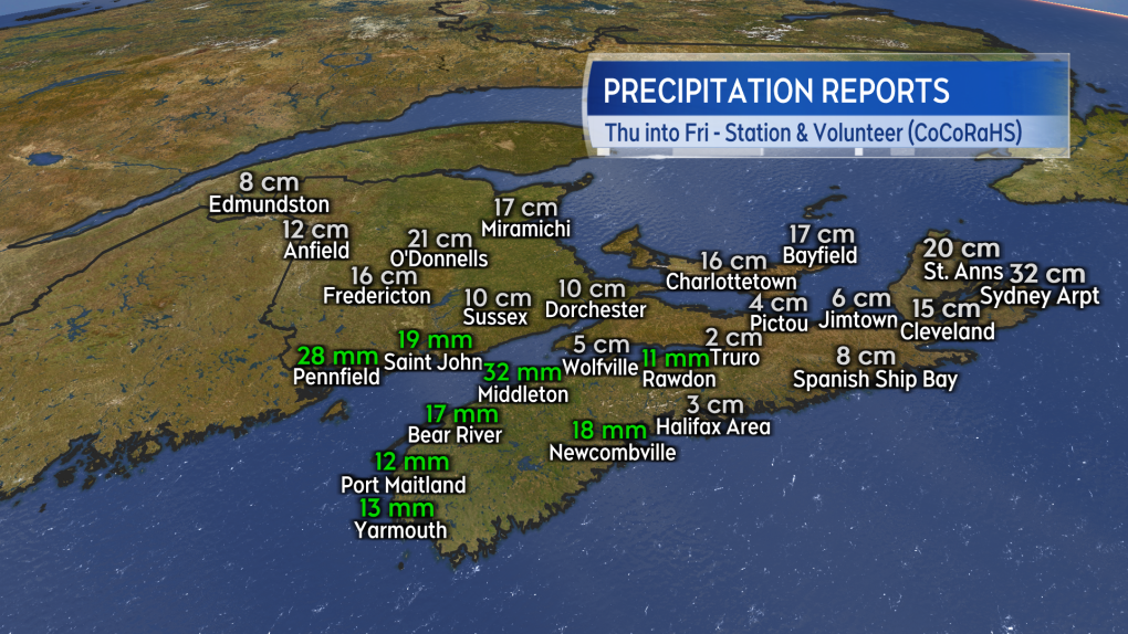 Preliminary and unofficial snow and rain reports for the Thursday/Friday system.
With a ridge of high-pressure building in from the west, Saturday will see the fairest weather of the weekend. There will be a general mix of sun and cloud and a low chance of flurries in Nova Scotia around the North Shore and Cape Breton.
High temperatures will generally be in the low-to-mid single digits for the Maritimes with communities on the South Shore of Nova Scotia possibly reaching 7 C to 10 C. Wind will be breezy and variable in direction for New Brunswick.
Wind will be blustery and from the north for both Nova Scotia and Prince Edward Island. That brings us to Sunday and our next round of active weather.
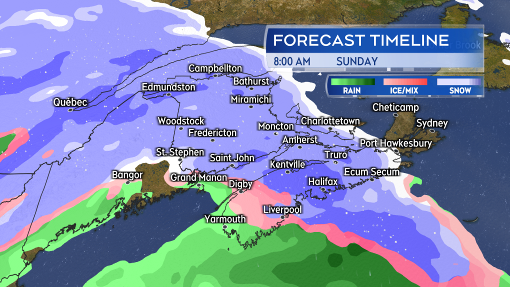 Snow returns Sunday morning to the Maritimes. The snow mixing over to ice pellets and rain in southwestern New Brunswick and western Nova Scotia.
As Saturday’s high-pressure shifts to the east, space will open for a low-pressure system to move in from the northeastern United States on Sunday.
Snow will likely start in western New Brunswick and western Nova Scotia before sunrise Sunday. The snow will reach eastern New Brunswick, Prince Edward Island, and eastern Nova Scotia before noon.
A turn from snow to a mix of ice pellets and rain is expected around coastal southwestern New Brunswick and western Nova Scotia. Snow, ice pellets and rain will become lighter Sunday evening. Lighter snow and flurries are likely to linger in some areas into Monday morning.
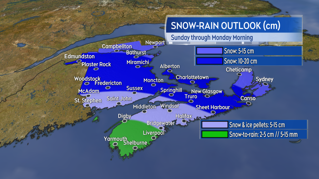 A large area of the Maritimes could pick up another 10 to 20 cm of snow. Snow amounts lower where more ice pellets and rain are present.
Given the mix of precipitation, it's hard to tell what amounts will look like – particularly at a time of year when the sun is getting stronger.
Once again, it looks like northern and eastern areas of the Maritimes will have the highest chance of picking up 10 to 20 cm of snow. Snow may taper lower in Cape Breton if the island ends up on the northern part of the storm.
Southwestern New Brunswick and central Nova Scotia will see varied amounts of five to 15 cm in a mix of snow, ice pellets, and rain. Accumulation there will be heavily dependent on the nature of that mix. A turn to rain does look likely in southwestern Nova Scotia, which may limit snow amounts there to five cm or less.
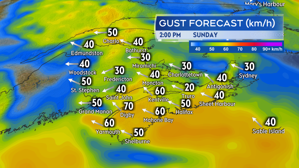 Gusty easterly winds will accompany the mix of snow, ice pellets, and rain Sunday.
A gusty, easterly wind will accompany the mix of precipitation. That wind will pick up Sunday morning into the afternoon. Gusts look to peak in the range of 40 to 70 km/h with the strongest on exposed areas of the coast and at higher terrain. The wind turns northerly and diminishes Sunday night into Monday morning.


CTVNews.ca Top Stories

DEVELOPING
DEVELOPING Alberta's request for federal assistance approved after fast-moving wildfire hit Jasper National Park: Trudeau
Prime Minister Justin Trudeau announced on social media that Ottawa has approved Alberta's request for federal assistance after a fast-moving wildfire hit Jasper National Park and its townsite late Wednesday.
Jasper mayor says alert system to be reviewed after message 'glitch'
More than 25,000 people have been displaced from Jasper National Park since wildfires started to threaten the picturesque corner of Alberta Rockies on Monday, but the mayor of its namesake municipality says not everyone received an evacuation alert when it was sent out.
Canada's premiers forced to confront escalating climate change-related disasters
Many of Canada's provincial and territorial leaders remained consumed by climate change-related natural disasters that have only escalated since they met for meetings in Halifax last week.
Norad intercepts Russian and Chinese bombers operating together near Alaska in apparent first
The North American Aerospace Defence Command (Norad) intercepted two Russian and two Chinese bombers flying near Alaska Wednesday in what appears to be the first time the two countries have been intercepted while operating together.
Biden explains why he ended re-election bid in Oval Office address
U.S. President Joe Biden on Wednesday delivered a solemn call to voters to defend the country's democracy as he laid out in an Oval Office address his decision to drop his bid for reelection and throw his support behind Vice President Kamala Harris.
Barrie-Innisfil MPP 'blacked-out' and crashed car into window of child care centre
Staff at a Barrie child care centre say they are frustrated by what they call a local MPP's inadequate response after a car crashed through a window in one of the toddler rooms.
Monday breaks the record for the hottest day ever on Earth
Driven by oceans that won't cool down, an unseasonably warm Antarctica and worsening climate change, Earth's record hot streak dialed up this week, making Monday the hottest day humans have measured.
Prince Harry says lawsuits against U.K. press 'central piece' in family breakdown
Prince Harry, speaking in clips published on Wednesday from a new documentary, said his legal battles with Britain's tabloid press have contributed to the breakdown of his relationship with the royal family.
2 Canadians being 'sent home immediately,' removed from Olympic team after drone incident
An analyst and an assistant coach with Canada Soccer are being removed from the Canadian Olympic Team and 'sent home immediately,' according to the Canadian Olympic Committee.
Shopping Trends
The Shopping Trends team is independent of the journalists at CTV News. We may earn a commission when you use our links to shop. Read about us.


Toronto
-

The Ontario Science Centre hosted a wedding the day after its dramatic shutdown
The day after the doors of the Ontario Science Centre closed to the public on the grounds that its roof was failing and unsafe, the centre’s management made an exception to allow a wedding and reception on its grounds.
-
One person dead after collision in Mississauga
One person is dead after a collision in Mississauga Wednesday afternoon.
-
Blue Jays sting Rays 6-3 with a four-run eighth inning
Back-to-back RBI singles with two out from Justin Turner and Daulton Varsho were enough to spark a four-run eighth inning and push the Toronto Blue Jays to a 6-3 win against the Tampa Bay Rays on Wednesday.
Calgary
-
 AS IT HAPPENED
AS IT HAPPENED Wildfire reaches Jasper Wednesday night, causes 'significant loss'
One of two wildfires threatening Jasper National Park reached the townsite Wednesday night and caused 'significant loss.'
-
New fire burning in Banff National Park south of Hector Lake
A new fire was reported to be burning in Banff National Park late Wednesday afternoon.
-
Canadian man killed in southern Israel has ties to Airdrie
A man from Alberta was gunned down in southern Israel on Monday, near the Gaza border while he was armed with a knife.
Edmonton
-
DEVELOPING
DEVELOPING Alberta's request for federal assistance approved after fast-moving wildfire hit Jasper National Park: Trudeau
Prime Minister Justin Trudeau announced on social media that Ottawa has approved Alberta's request for federal assistance after a fast-moving wildfire hit Jasper National Park and its townsite late Wednesday.
-
Multiple structures ablaze as wildfire roars into Jasper townsite
One of two raging, wind-whipped fires menacing Jasper, Alta., roared into town Wednesday night and began burning buildings.
-
Jasper mayor says alert system to be reviewed after message 'glitch'
More than 25,000 people have been displaced from Jasper National Park since wildfires started to threaten the picturesque corner of Alberta Rockies on Monday, but the mayor of its namesake municipality says not everyone received an evacuation alert when it was sent out.
Montreal
-

Quebec athlete named one of Canada's 2024 Olympic flag bearer
Maude Charron will carry the Canadian flag during Friday's Olympic opening ceremony in Paris. The athlete from Rimouski will also be defending her Olympic gold medal in weightlifting.
-
Montreal electronic traffic signs hacked to display pro-Palestinian political slogans
Montreal police are investigating after electronic message boards at two road construction sites in Montreal displayed pro-Palestinian political slogans Wednesday morning instead of usual traffic alerts.
-
Service resumes on the metro's orange line after water main leak: STM
Montreal's transit authority said a water main break disrupted service on part of the metro's orange line during the afternoon commute Wednesday.
Ottawa
-
 SEVERE THUNDERSTORM WATCH
SEVERE THUNDERSTORM WATCH Severe storms move across eastern Ontario, prompting weather warnings
A series of weather watches were issued across Ottawa and eastern Ontario, as severe storms moved through the area Wednesday.
-
NEW THIS MORNING
NEW THIS MORNING These were the most commonly stolen vehicles in Ottawa in June
Ottawa police are noting a developing trend in the types of vehicles that are being targeted by thieves in the capital.
-
Canada soccer fans express shock, disappointment from Olympic team drone incident
The Olympics begin Friday, but it's been an embarrassing debut for the Canada’s women's soccer team who are now embroiled in a major scandal.
London
-

17-year-old victim of intimate partner violence was previously violently attacked by her partner
17-year-old Breanna Broadfoot, who will be honoured with a vigil on Wednesday night, had allegedly previously been attacked by her partner, residing in the same home where she later received fatal injuries.
-
Driver walks home after police tow vehicle that revved at Mitchell stop light
Nobody likes a loud and aggressive driver – but one such driver caught the attention of the wrong police officer when they revved their engine at a red light in Mitchell in early July.
-
Political U-turn kills plan to reduce speed limits in dozens of school zones on London’s busiest roads
On Tuesday, a majority of council rejected a recommendation by the Civic Works Committee that would have reduced speed limits by 10 km/hr in school zones along arterial roads during periods when students are usually present.
Barrie
-

Barrie-Innisfil MPP 'blacked-out' and crashed car into window of child care centre
Staff at a Barrie child care centre say they are frustrated by what they call a local MPP's inadequate response after a car crashed through a window in one of the toddler rooms.
-
New police vehicle turns heads along Barrie's waterfront
Barrie police are using a utility vehicle along the city's waterfront this summer to help officers get to challenging locations and increase their presence throughout the busy area.
-
What does Bank of Canada's interest rate cut mean for homeowners?
The Bank of Canada lowered its key interest rate to 4.5 per cent, as those looking to renew or buy a mortgage watched closely.
Northern Ontario
-

2 Canadians being 'sent home immediately,' removed from Olympic team after drone incident
An analyst and an assistant coach with Canada Soccer are being removed from the Canadian Olympic Team and 'sent home immediately,' according to the Canadian Olympic Committee.
-
Northern Ont. reaction to Canada's Olympic controversy
With soccer growing in popularity in Sudbury, some with experience in the sport are with confusion and disappointment to the recent news out of the Olympics.
-
Barrie-Innisfil MPP 'blacked-out' and crashed car into window of child care centre
Staff at a Barrie child care centre say they are frustrated by what they call a local MPP's inadequate response after a car crashed through a window in one of the toddler rooms.
Kitchener
-

Guelph, Ont. police constable continues to fight for his job
A police constable in Guelph, Ont. pleaded guilty Wednesday to discreditable conduct – for a second time.
-
Cambridge mother blames GRCA for flood that destroyed her belongings
A Cambridge woman explains why she blames the GRCA for a flood that damaged her home and forced her family to flee in a canoe.
-
Wanted teen considered dangerous after escaping secure custody facility: WRPS
The Waterloo Regional Police Service (WRPS) is searching for a 16-year-old they say escaped a security custody facility in Wilmot Township.
Windsor
-

'We want what's best for the neighbourhood': Residents given more time to lobby for change
The residents of Spago Crescent in South Windsor are open to change.
-
Thousands expected for car festival this weekend In Amherstburg
This weekend, the town of Amherstburg will be a car-lover's dreamland come true.
-
Politicians come together to celebrate Gordie Howe International Bridge deck connection
Politicians came together at the Gordie Howe International Bridge Wednesday afternoon to celebrate its deck connection.
Winnipeg
-

Search of North End property linked to 2021 missing person case
The Winnipeg Police Service (WPS) is executing a search warrant at a North End property on Wednesday to look for evidence linked to a missing person case from 2021.
-
Elementary school in Thompson goes up in flames
An elementary school in Thompson, Man., has gone up in flames on Wednesday.
-
Church of rock: Jets owner, The Brothers Landreth save dwindling Winnipeg church, give it added purpose
A saving grace for a dwindling Winnipeg church has come in the form of Winnipeg Jets owner Mark Chipman and Juno-award-winning folk duo The Brothers Landreth.
Regina
-

Sask. WWII veteran, 103, receives France's highest national order
A Saskatchewan-born veteran of the Second World War was recently presented with France's highest national order.
-
Traffic restrictions in place after crash near Highway 1: Moose Jaw police
Drivers passing through Moose Jaw can expect some delays following a crash near Highway 1.
-
Water upgrades near completion at Buffalo Pound Water Treatment Plant
Residents in Regina and Moose Jaw will soon have better tasting water.
Saskatoon
-

'A bright light': Trevor LaPlante identified as Prince Albert homicide victim
Prince Albert is grieving the loss of one of its most beloved neighbours and community champions.
-
'It's a big deal': Harmful invasive species a growing concern in Saskatchewan lakes
As people get out and enjoy the many lakes in our province this summer, those who take care of the waterways are warning about dangerous invasive species that’s a growing threat in Saskatchewan.
-
Sask. WWII veteran, 103, receives France's highest national order
A Saskatchewan-born veteran of the Second World War was recently presented with France's highest national order.
Vancouver
-

'How can we be going backwards?' Vancouver city council votes to allow natural gas heat in new buildings
Vancouver city council has voted to allow natural gas for heating and hot water in new construction.
-
'We've pretty much lost our range': Ranch manager loses second range in 3 years to wildfires
T.J. Walkem, along with more than 80 of his cows, has spent the last few days desperately trying to evade the out-of-control Shetland Creek wildfire.
-
80,000 lightning flashes in B.C. in 3 days
Environment Canada has recorded a whopping 80,007 lightning flashes in British Columbia from Sunday through Tuesday, and the count continues on Wednesday for what could be a record-breaking stretch.
Vancouver Island
-

'No known connections' between recent sexual assaults on Vancouver Island, police say
Police on Vancouver Island are investigating three sexual assaults by strangers that were reported in the past week, though there is no indication the attacks are connected.
-
Vacations, meals, booze: Contractor used $100K of charity's money for personal expenses, B.C. court finds
A B.C. man who was hired to help a non-profit build a food hub but instead spent the money on personal expenses – including travel, restaurants, booze and cannabis – has been ordered to pay more than $120,000 in damages.
-
Vancouver Island wildfire grows overnight, remains out of control
A wildfire burning out of control on Vancouver Island continued to spread Wednesday as the provincial wildfire service assigned more resources to try to contain the blaze.
Kelowna
-

Kamloops RCMP officer charged with assault, mischief
A Kamloops Mountie has been charged with assault and mischief in connection to an incident that occurred last summer, Crown prosecutors announced Wednesday.
-
2 dead after serious crash on Highway 1 in B.C. Interior
Two people are dead after a serious crash that shut down Highway 1 near Sorrento, B.C. Saturday morning.
-
Structures lost to Shetland Creek wildfire as more heat, thunderstorms strike parts of B.C.
The number of wildfires in British Columbia has flared as more lightning storms bring the potential for further fire starts.


