More spring snow to hit the Maritimes Sunday
While one round of snow and rain has passed, another is lined up for the end of the weekend.
The system that rolled through Thursday night into Friday brought the most snow to parts of northern and eastern New Brunswick, Prince Edward Island, and Cape Breton.
Those areas of New Brunswick and Prince Edward Island saw a widespread 10 to 20 cm. Meanwhile, Victoria County and the Sydney Metro-Cape Breton County areas saw snow totals in the 20 to 35 cm range.
More snow is possible for Cape Breton Friday night into early Saturday morning as a northwesterly wind brings in flurries off the Gulf of St. Lawrence.
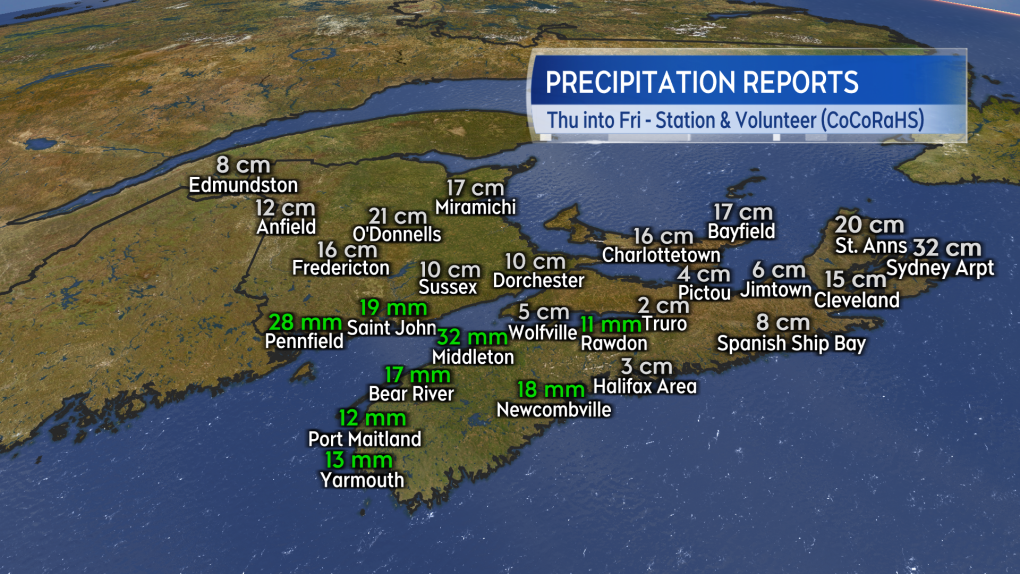 Preliminary and unofficial snow and rain reports for the Thursday/Friday system.
With a ridge of high-pressure building in from the west, Saturday will see the fairest weather of the weekend. There will be a general mix of sun and cloud and a low chance of flurries in Nova Scotia around the North Shore and Cape Breton.
High temperatures will generally be in the low-to-mid single digits for the Maritimes with communities on the South Shore of Nova Scotia possibly reaching 7 C to 10 C. Wind will be breezy and variable in direction for New Brunswick.
Wind will be blustery and from the north for both Nova Scotia and Prince Edward Island. That brings us to Sunday and our next round of active weather.
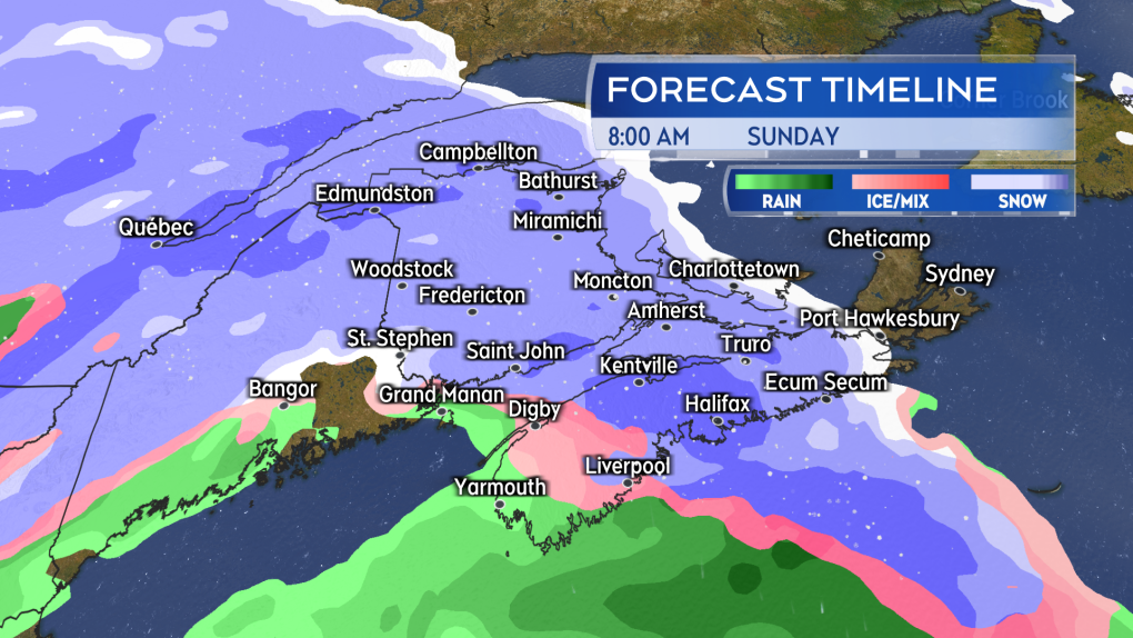 Snow returns Sunday morning to the Maritimes. The snow mixing over to ice pellets and rain in southwestern New Brunswick and western Nova Scotia.
As Saturday’s high-pressure shifts to the east, space will open for a low-pressure system to move in from the northeastern United States on Sunday.
Snow will likely start in western New Brunswick and western Nova Scotia before sunrise Sunday. The snow will reach eastern New Brunswick, Prince Edward Island, and eastern Nova Scotia before noon.
A turn from snow to a mix of ice pellets and rain is expected around coastal southwestern New Brunswick and western Nova Scotia. Snow, ice pellets and rain will become lighter Sunday evening. Lighter snow and flurries are likely to linger in some areas into Monday morning.
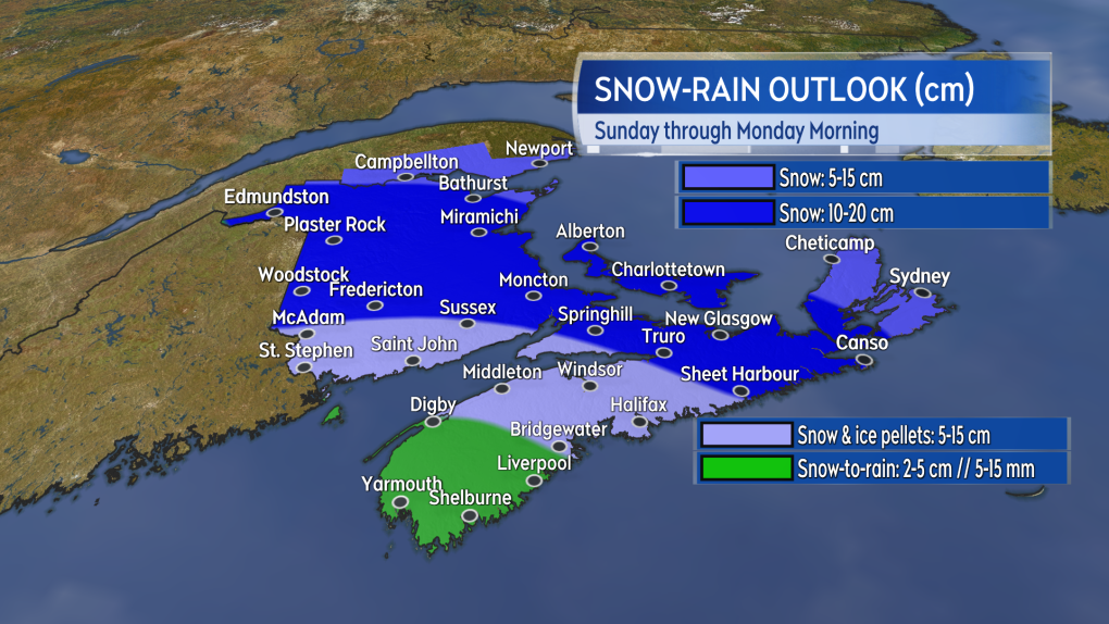 A large area of the Maritimes could pick up another 10 to 20 cm of snow. Snow amounts lower where more ice pellets and rain are present.
Given the mix of precipitation, it's hard to tell what amounts will look like – particularly at a time of year when the sun is getting stronger.
Once again, it looks like northern and eastern areas of the Maritimes will have the highest chance of picking up 10 to 20 cm of snow. Snow may taper lower in Cape Breton if the island ends up on the northern part of the storm.
Southwestern New Brunswick and central Nova Scotia will see varied amounts of five to 15 cm in a mix of snow, ice pellets, and rain. Accumulation there will be heavily dependent on the nature of that mix. A turn to rain does look likely in southwestern Nova Scotia, which may limit snow amounts there to five cm or less.
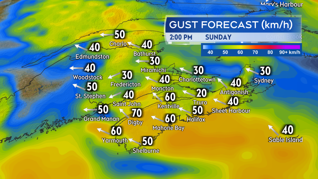 Gusty easterly winds will accompany the mix of snow, ice pellets, and rain Sunday.
A gusty, easterly wind will accompany the mix of precipitation. That wind will pick up Sunday morning into the afternoon. Gusts look to peak in the range of 40 to 70 km/h with the strongest on exposed areas of the coast and at higher terrain. The wind turns northerly and diminishes Sunday night into Monday morning.


CTVNews.ca Top Stories

Which Canadian cities have the highest and lowest grocery prices?
Where you live plays a big factor in what you pay at the grocery store. And while it's no secret the same item may have a different price depending on the store, city or province, we wanted to see just how big the differences are, and why.
'State or state-sponsored actor' believed to be behind B.C. government hacks
The head of British Columbia’s civil service has revealed that a “state or state-sponsored actor” is behind multiple cyber-security incidents against provincial government networks.
Swarm of 20,000 bees gather around woman’s car west of Toronto
A swarm of roughly 20,000 bees gathered around a woman’s car in the parking lot of Burlington Centre.
Mother assaulted by stranger while breastfeeding baby in her car: Vancouver police
A person was arrested in East Vancouver Thursday after allegedly entering a car while a mother was breastfeeding her four-month-old boy.
More than half the Canadians once detained in Syrian camps for suspected ISIS family members have returned home
A total of 29 Canadians have been freed from detention camps in northeast Syria and brought back to Canada since human rights advocates began lobbying for their release years ago.
Rare severe solar storm Friday could bring spectacular aurora light show across Canada
A rare and severe solar storm is expected to bring spectacular displays of the northern lights, also known as aurora borealis, across much of Canada and parts of the United States on Friday night.
Canada abstains from Palestinian UN membership vote but supports two-state solution
Canada was one of 25 countries that abstained from a United Nations vote on Palestinian membership that passed with overwhelming support on Friday.
Amish youth experience a rite of passage called Rumspringa. It’s not what you might think
The idea of “Rumspringa” has a specific spot in the American imagination. A rite of passage for young people in some Amish communities, Rumspringa is seen by most outsiders as a wild time away from strict Amish rules, when teenagers can experiment with the modern vices of the world.
Djokovic needs medical attention after getting knocked on the head by a water bottle at Italian Open
Novak Djokovic needed medical attention after apparently getting knocked on the head by a water bottle after a win at the Italian Open on Friday.
Shopping Trends
The Shopping Trends team is independent of the journalists at CTV News. We may earn a commission when you use our links to shop. Read about us.


Toronto
-

Swarm of 20,000 bees gather around woman’s car west of Toronto
A swarm of roughly 20,000 bees gathered around a woman’s car in the parking lot of Burlington Centre.
-
'Just wait': Toronto mayor hints that WNBA team is coming to the city amid multiple reports
Toronto Mayor Olivia Chow says that she is hopeful an announcement could be made soon amid multiple reports that a WNBA team is coming to Toronto in 2026.
-
What to know about road and transit closures in Toronto this weekend, May 11-12
Here are the road closures in Toronto this weekend to keep in mind.
Calgary
-

City of Chestermere inspection reveals ‘irregular, improper and improvident’ financial management: province
A third-party examination of the City of Chestermere revealed “significant gaps” in the financial management, the province said Friday.
-
'We have laws': Premier Smith says police action justified in Calgary
The actions, including the decision to use non-lethal force, to disperse pro-Palestinian protesters from the University of Calgary campus were justified, Alberta Premier Danielle Smith said Friday.
-
Calgary approves all 28 recommendations from downtown safety panel
The City of Calgary has approved more than two-dozen recommendations to improve safety and vibrancy in the downtown core.
Edmonton
-

'Violent, despicable and unbelievable': Family of murdered 7-year-old speak at David Moss sentencing Friday
David Moss, the man who murdered seven-year-old Bella Rose Desrosiers, broke down in court Friday as the girl's family spoke about the toll her death has taken on them.
-
Oilers star Leon Draisaitl questionable for Game 2 vs. Canucks
Edmonton Oilers star Leon Draisaitl is questionable for today's Game 2 against the Vancouver Canucks.
-
Out-of-control wildfire burning near Fort McMurray
As of 9 a.m. on Friday, the wildfire burning 28 kilometres southwest of the northeastern Alberta city was 25 hectares in size.
Montreal
-
 BREAKING
BREAKING McGill University seeks injunction to remove pro-Palestinian encampment from campus
McGill University has filed a request for an injunction to have the pro-Palestinian encampment removed from its campus.
-
Man charged after truck strikes and kills driver changing flat tire on side of Montreal-area highway
A 43-year-old man has been charged after a driver was struck and killed while changing a tire on the side of a Highway 15 near Montreal on Thursday.
-
This iconic Canadian song is turning 50
Andy Kim's 'Rock Me Gently' is marking a major milestone, as it celebrates its 50th anniversary.
Ottawa
-

Ottawa man charged in connection to fatal shooting at Manor Park home
A 20-year-old man is facing a charge of second-degree murder in connection to a fatal shooting during a poker game in Ottawa's Manor Park neighbourhood.
-
'The whole community is devastated': Sharbot Lake, Ont. mourning the death of teen in crash
A high school student at Granite Ridge Education Centre in Sharbot Lake, Ont. died in a single-vehicle crash on Thursday. Five other students were injured in the crash.
-
Ottawa's 3-container limit for curbside garbage takes effect this fall
The City of Ottawa's new three-garbage item limit for household waste will take effect on Sept. 30, with a three-month phase-in period for the limit. As of December, collection staff will only collect three garbage items from households every two weeks.
London
-

Suspicious fire being investigated in London
A suspicious fire in London is under investigation by police and fire officials. According to London fire, crews knocked down the scene in an “offensive strategy.”
-
London Majors debut new look for 100th season
The London Majors is debuting a new look ahead of the 2024 season. Fans can expect changes ton the brand and on-field look as well as two new logos to celebrate the 100th season of the majors.
-
'The need is immeasurable': St. Thomas Elgin Food Bank usage doubles
Officials at the St. Thomas Elgin Food Bank report a 50 per cent jump in usage over the past three years.
Barrie
-
Barrie men charged with fraud in OPP investigation into pool installation scam
Two Barrie men have been charged with fraud in connection with a lengthy OPP investigation after several customers seeking pool installations were allegedly scammed out of thousands of dollars.
-
OPP probes $50,000 damage to Hydro One infrastructure in Muskoka
Provincial police are investigating after extensive damage was done to Hydro One equipment in Muskoka.
-
Here's why your yard waste may have been sitting at the curb for days
A recent change in curbside collection has left some green-thumbed enthusiasts scratching their heads as bags of yard waste linger by the curb, awaiting pickup.
Northern Ontario
-
Dashcam video shows terrifying near-miss on two-lane northern Ontario highway
There were some scary moments for several people on a northern Ontario highway caught on video Thursday after a chain reaction following a truck fire.
-
Twenty defendants fined $222K for northern Ont. moose hunt violations
A large group of Canadian and U.S. defendants have been fined $178,400 plus $44,525 in surcharges for a variety of moose hunting violations in northwestern Ontario.
-
Radical anti-government rhetoric appears in northern Ont. court case
A northern Ontario couple who ran afoul of Ontario’s building code used arguments reminiscent of radical anti-government groups in a failed attempt to defend their stance in court.
Kitchener
-

9-year-old prodigy pianist to perform with former K-W Symphony musicians
A young prodigy pianist is set to perform alongside former members of the Kitchener-Waterloo Symphony, as part of a benefit concert.
-
What you should keep in your emergency supply kit
Could you survive for 72 hours following a natural disaster? The Region of Waterloo is hoping that question sparks a conversation around emergency preparedness.
-
Ontario coroner to investigate death of man who suffered cardiac arrest while waiting in ER
A provincial coroner will be investigating the death of 68-year-old David Lippert, who suffered a cardiac arrest while waiting in a crowded emergency room in Kitchener, Ont.
Windsor
-

Windsor’s unemployment rate jumps back into highest in Canada
The unemployment rate in Windsor increased dramatically last month and is the highest in Canada, according to Statistics Canada.
-
City of Windsor has unanswered questions as feds, province spar over housing funding
A dispute between the federal and provincial governments over the National Housing Strategy nearly put the City of Windsor $7 million in the hole and questions still remain over when and how much funding the city will receive.
-
Highway 401 ramps at Queens Line closed after crash
OPP are informing the public of a crash on the Highway 401 ramps at Queens Line in Chatham-Kent.
Winnipeg
-
'Devastating': Businesses concerned over watercraft ban on Clear Lake
Businesses in the Clear Lake area are concerned about the future following a temporary ban on watercraft from entering the lake.
-
Roughly 250 people forced to evacuate Winnipeg apartment building deemed unsafe
Approximately 250 residents of a St. James area apartment building will have to leave their homes immediately, as the City of Winnipeg issued a vacate order over unsafe conditions.
-
Solar storm could produce highly visible northern lights in Manitoba
An unusually large solar storm could produce northern light shows that may be visible across most of Canada on Friday and Saturday.
Regina
-

Sask. teachers, province both seek return to bargaining following offer rejection
Saskatchewan Teachers' Federation (STF) president Samantha Becotte says she was not surprised that teachers voted no to the province's latest contract offer. Both sides appear ready and willing to resume negotiations.
-
Regina police charge 3, seize drugs, ammunition after 'months long investigation'
Regina police say three people have been charged after they seized more than 1,100 grams of a substance believed to be cocaine along with suspected meth and ammunition following a “months long investigation.”
-
Which Canadian cities have the highest and lowest grocery prices?
Where you live plays a big factor in what you pay at the grocery store. And while it's no secret the same item may have a different price depending on the store, city or province, we wanted to see just how big the differences are, and why.
Saskatoon
-
Sask. teachers, province both seek return to bargaining following offer rejection
Saskatchewan Teachers' Federation (STF) president Samantha Becotte says she was not surprised that teachers voted no to the province's latest contract offer. Both sides appear ready and willing to resume negotiations.
-
Nutrien CEO wants fully automated or tele-remote operations in all 6 mines
Improved mine automation helped fertilizer giant Nutrien Ltd. increase potash production in the first quarter amid strong demand for its products, the company's chief executive said.
-
Saskatchewan sky watchers say conditions are perfect for 'extremely strong aurora' on Friday
Saskatchewan sky watchers say the conditions are perfect for a vibrant show of aurora borealis starting on Friday night.
Vancouver
-

'State or state-sponsored actor' believed to be behind B.C. government hacks
The head of British Columbia’s civil service has revealed that a “state or state-sponsored actor” is behind multiple cyber-security incidents against provincial government networks.
-
B.C. finance minister says she will retire following provincial election this fall
British Columbia's finance minister says she won't be running again in the next provincial election after serving in the legislature for nearly two decades.
-
B.C. halts new jade mining in northwest, five-year transition for existing operations
British Columbia has prohibited mining activities on new jade tenures in the northwest, while setting a five-year wind-down period for existing operators.
Vancouver Island
-

Police launch assault investigation at UVic protest encampment
Police in Saanich, B.C., say an assault investigation is underway following two alleged incidents at a pro-Palestinian protest encampment on the grounds of the University of Victoria.
-
Victoria police searching for man accused of voyeurism in downtown store
Police in Victoria are appealing to the public to identify a man who allegedly took photos or video of a woman in a change room at a downtown store Wednesday afternoon.
-
Vancouver robbery suspect facing 12 charges after businesses targeted
A 29-year-old man is facing a dozen robbery charges after a months-long string of burglaries at Vancouver businesses.
Kelowna
-
Kamloops RCMP issue public warning about 2 men allegedly at centre of 'organized crime conflict'
After four targeted shootings in four days, Mounties in Kamloops are taking the unusual step of warning the public about two men they believe are likely to be targeted in future violent incidents.
-
Community mourns thousands of fish lost as B.C. drought risk looms again
Images of steelhead and trout flicker over long sheets of paper, brought to life in blue and green crayon rubbings by the thousands.
-
4th targeted shooting in as many days in Kamloops: RCMP
A man was taken to hospital with non-life-threatening injuries after a shooting in Kamloops Monday evening, the fourth incident police say is part of an ongoing drug conflict playing out on the city's streets.


