More than 30 cm of spring snow expected for parts of the Maritimes this weekend
I’d call it the Maritimes’ own version of Sheila’s Brush.
Sheila’s Brush is Newfoundland weather folklore that expects a storm to follow shortly after St. Patrick’s Day, with the storm “brushing out” the last of winter. Given the stormy weather lined up for the weekend in the Maritimes, I think this one could qualify.
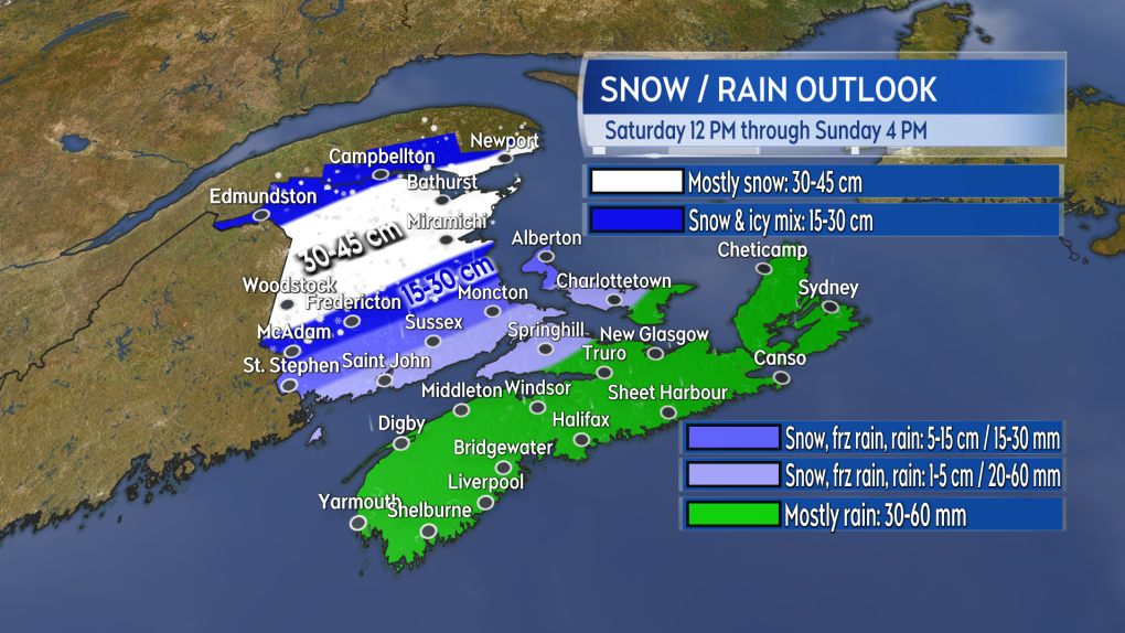 A mix of heavy snow and heavy rain comes through this weekend. The most snow is expected in northern and central areas of New Brunswick.
New Brunswick
A chance of flurries Saturday morning will be followed by snow developing through the afternoon. Snow will then be heavy for northern and central areas of New Brunswick by the evening. Snow changing through to ice pellets and freezing rain to rain is expected Saturday evening and night for southern New Brunswick. The mix of weather will be clearing the province, west-to-east, through Sunday morning.
The most snow is expected in the area from near Woodstock north to Grand Falls and then northeast towards communities like Bathurst and Miramichi. This will be a very heavy spring snow with potential amounts of 30 to 45 cm. The very northwestern corner of the province, the area from Edmundston to Campbellton-Dalhousie, could finish a bit lower with 10 to 20 cm of snow. Fredericton could see 15 cm or more of accumulation in a heavy mix of snow, ice pellets, and freezing rain. Rain totals in southern New Brunswick could be as much as 20 to 60 mm.
Expect snow-covered roads and winter driving conditions to develop across much of central and northern New Brunswick Saturday afternoon through Saturday night.
Southerly gusts in southern New Brunswick could peak as high as 50 to 70 km/h Saturday night. A northwest wind with gusts of 20 to 50 km/h is expected for Sunday.
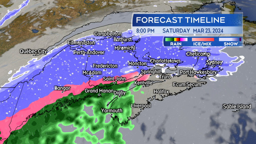 Weather conditions deteriorate across the Maritimes Saturday evening and night.
Nova Scotia
Some light snow or flurries will develop across mainland Nova Scotia Saturday afternoon. Localized snow amounts of one to five cm is possible. Temperatures rise Saturday night and rain, heavy at times, will develop. The rain will continue into Sunday morning and then will clear west-to-east through Sunday afternoon. The last of the rain may turn to a brief period of snow before clearing.
Rain totals of 20 to 60 mm are expected. There is a risk of some freezing rain in Cumberland/Colchester Counties Saturday evening.
Pooling water could lead to hydroplaning conditions on the roads. Heavy and wind-blown rain may reduce visibility at times.
A south wind will increase to include gusts of 50 to 80 km/h Saturday night. Due to the topography of the Highlands, gusts in northern Inverness County could reach 100+ km/h. The wind will become northwest with gusts of 30 to 60 km/h Sunday afternoon.
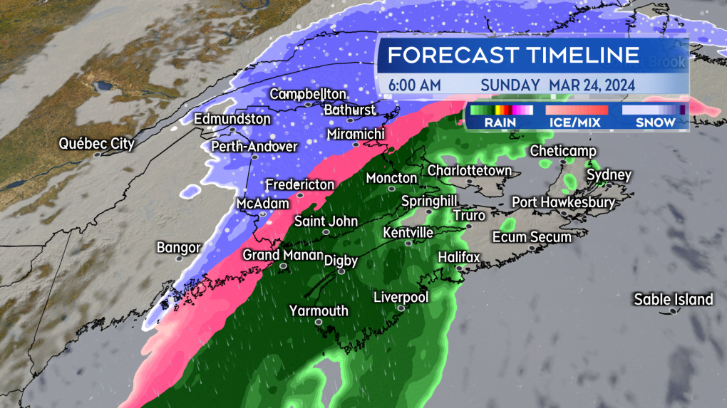 The mix of snow and rain will clear the Maritimes, west-to-east, Sunday morning through Sunday afternoon.
Prince Edward Island
Snow will reach Prince Edward Island by late Saturday afternoon. The snow will change through to ice pellets and freezing rain to rain Saturday night. Prince County could remain in a mixture of snow, ice pellets, and freezing rain until early Sunday morning. The rain will clear P.E.I. through Sunday afternoon. The last of the rain may turn briefly back to a period of snow.
Initial snow should be limited to five cm or less for most of P.E.I. Parts of Prince County could see five to 15 cm as the snow and ice pellets may persist longer into Saturday night before turning to rain. Rain amounts of 15 to 25 mm are expected.
Watch for some greasy road conditions and reduced visibility Saturday evening as the snow initially arrives.
Southerly wind gusts will peak in the range of 50 to 80 km/h early Sunday morning. By Sunday afternoon, the wind will become northwest with gusts of 30 to 60 km/h.
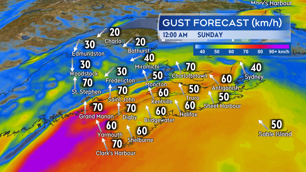 High and gusty southerly winds are expected for southern New Brunswick, Nova Scotia, and P.E.I. Saturday night into early Sunday morning.


CTVNews.ca Top Stories

Trudeau acknowledges charges in Nijjar killing, calls for commitment to democracy
Prime Minister Justin Trudeau has acknowledged the charges laid Friday in relation to the murder of B.C. Sikh activist Hardeep Singh Nijjar.
No proof man lied to brother about number of kittens born in litter, B.C. tribunal rules
A man was denied a $5,000 payout from his brother after a B.C. tribunal dismissed his claim disputing how many kittens were born in a litter.
Bodies recovered in Mexico likely 2 Australians, 1 American who went missing: officials
Three bodies recovered in an area of Baja California are likely to be those of the two Australians and an American who went missing last weekend during a camping and surfing trip, the state prosecutor’s office said Saturday.
Princess Anne lays wreath at B.C. veteran's cemetery; receives 21-gun salute
Princess Anne paid tribute to veterans buried at a cemetery in British Columbia today, laying a wreath to honour the more than 2,500 military personnel and family members buried there.
Mystik Dan wins the 150th Kentucky Derby at Churchill Downs in a three-horse photo finish
Mystik Dan won the 150th Kentucky Derby in a photo finish, edging out Forever Young and Sierra Leone for the upset victory.
'I just can't believe that it took so long': Body found in wreckage 3 months after deadly fire
A man accused of arson in a January Old Strathcona apartment fire is expected to be charged with manslaughter after a body was discovered in the burned building late last month.
Quebec police hand out hundreds of tickets to Hells Angels and other bikers before 'first run' meeting
Quebec provincial police handed out hundreds of fines to Hells Angels members and other supporting motorcycle clubs who met for their 'first run' in a small town near Sherbrooke, Que.
Work stoppage possible as WestJet issues lockout notice to maintenance engineers' union
A lockout notice issued by WestJet to a union representing aircraft maintenance engineers could result in a work stoppage next week.
London Drugs begins 'gradual reopening' on 7th day after cyberattack
Almost a week after all London Drugs stores across Western Canada abruptly closed amid a cyberattack, they began a "gradual reopening" on Saturday.
Shopping Trends
The Shopping Trends team is independent of the journalists at CTV News. We may earn a commission when you use our links to shop. Read about us.


Toronto
-

Pastrnak scores winner, Bruins down Leafs 2-1 in overtime in Game 7
David Pastrnak scored at 1:54 of overtime as the Boston Bruins downed the Toronto Maple Leafs 2-1 in Game 7 to advance to the second round of the Stanley Cup playoffs on Saturday.
-
Driver airlifted to hospital with critical injuries after car and train collide in Caledon
A driver has been airlifted to the hospital after a car collided with a train in Caledon.
-
Police investigating stabbing in Rexdale that sent man to hospital
A man is in hospital after being stabbed in Rexdale Saturday afternoon.
Calgary
-

Serious collision impacts traffic along Highway 2A near Aldersyde
Emergency crews are on scene of a serious collision on Highway 7 at 32 Street East in Okotoks.
-
Work stoppage possible as WestJet issues lockout notice to maintenance engineers' union
A lockout notice issued by WestJet to a union representing aircraft maintenance engineers could result in a work stoppage next week.
-
Netflix is filming a western series in Calgary starting this month
Netflix is set to begin filming a western series with a star-studded cast in Calgary this month. The Abandons, created by Kurt Sutter from Sons of Anarchy fame, follows “a group of diverse renegade families living on the fringes of society in 1850s Oregon.”
Edmonton
-

2 motorcyclists hit on Highway 21 after vehicle crosses centre line near New Sarepta Saturday: RMCP
RCMP closed a stretch of Highway 21 near New Sarepta on Saturday afternoon after a serious crash involving two motorcycles.
-
1 dead, 1 arrested after Friday morning assault near Alberta Avenue
A man is dead after an assault Friday morning near Alberta Avenue.
-
London Drugs begins 'gradual reopening' on 7th day after cyberattack
Almost a week after all London Drugs stores across Western Canada abruptly closed amid a cyberattack, they began a "gradual reopening" on Saturday.
Montreal
-

Montreal man on the hook for thousands of dollars after a feature on his Tesla caused an accident
A Montreal man is warning Tesla drivers about using the Smart Summon feature after his vehicle hit another in a parking lot.
-
Sandy Beach in Hudson, Que. closed for the summer
The town of Hudson, Que. has closed Sandy Beach for the summer, just as the weather is starting to be warm enough to enjoy it.
-
Crowds show up in Kahnawake for Star Wars Day at collectibles expo
Hundreds of vendors, collectibles and sci-fi and fantasy nerds of all stripes took in the K-Town Collectibles Expo in Kahnawake Que. that kicked off on Star Wars Day, May the fourth.
Ottawa
-
 NEW THIS MORNING
NEW THIS MORNING This Ottawa parent was frustrated by the City of Ottawa's website – So she built her own
It's been a longstanding struggle for Ottawa parents – navigating the city's activities website to find programs and classes.
-
'We're scared': Firefighters battle 2nd blaze in Overbrook highrise in 2 days
Ottawa Fire Services say crews battled a fire that broke out in the bedroom of an Overbook highrise on Friday evening - less than 48 hours after a fire in the same building displaced hundreds of residents and sent three people to hospital in critical condition on Thursday.
-
Students staying put on uOttawa's campus as pro-Palestinian encampment continues
Students say they will stay put at an encampment in front of uOttawa until the university divests from companies and organizations with ties to Israel.
London
-

Downtown road closure may disrupt traffic this week
Starting Monday, Talbot Street will be closed between John Street and Mill Street to allow for the removal of a tower crane.
-
Steps for Life: Annual fundraiser walk to raise awareness about workplace tragedies
Threads of Life held its 16th annual Steps for Life fundraiser walk for the London, Ont. region at Springbank Park.
-
May the 4th strikes back: Geeks and Co. holding Star Wars event to raise money for charity
May the 4th traditionally marks Star Wars Day, and some London, Ont. area fanatics are expressing their love for the movie franchise.
Barrie
-

Canadian Armed Forces and first responders team up for training in Wasaga Beach
With fire season just around the corner, the Canadian Armed Forces (CAF) teamed up with local first responders in Wasaga Beach on Saturday to enhance their readiness in the event of a domestic emergency.
-
OPP investigating online gambling operation in Orillia
OPP is investigating an online gambling operation within Orillia High Schools.
-
One Person seriously injured after vehicle collided with train in Caledon
One Person has been transported to a trauma centre with life-threatening injuries after a vehicle collided with a train in Caledon on Saturday.
Northern Ontario
-

Police lay second-degree murder charge in northwestern Ont.
Ontario Provincial Police, in partnership with the Treaty Three Police Service, have charged a suspect with second degree murder following a homicide in a remote Indigenous northwestern Ontario community.
-
Feds hope to table foreign interference legislation next week: LeBlanc
Democratic Institutions Minister Dominic LeBlanc says he plans to table legislation this week to help the federal government address foreign interference, but he wouldn't say whether the proposal will include a foreign agent registry.
-
Police find human remains in remote northern Ont. hamlet
Shortly after 9 a.m. on May 3, Ontario Provincial Police (OPP) found human remains in a wooded area near Katrine, Ont.
Kitchener
-

'It was completely underwater': Cambridge community remembers devastating flood 50 years later
May 17, 1974 started off like any other sunny spring day, but it very quickly turned into a day of disaster.
-
WRDSB to lay off 106 elementary school teachers
More than 100 teachers at the Waterloo Region District School Board (WRDSB) are learning they have been declared surplus will likely be out of a job as of Aug. 12.
-
Chemical spill could be cause of stinky water in Puslinch, Ont., new report says
People living in Puslinch, Ont. may have the answer to why their water smelled so bad last year.
Windsor
-

Windsor theatre performer hopes locally-shot original comedy series changes perception of people with disabilities
In the few years since he became completely blind and lost both of his legs in back-to-back amputations, Michael Potter says he is used to people treating him differently — almost to the point of insulting.
-
Canada's oldest and largest high school hack-a-thon reaches decade milestone
An annual 24-hour competition that allows students to explore the realm of computer science and bring their ideas to life by developing a project of their own has reached a milestone this weekend.
-
Teen charged in connection with armed robbery
The Windsor Police Service has arrested a 17-year-old boy following an armed robbery in the city’s west end.
Winnipeg
-

Winnipeg police investigating after pedestrian hit by vehicle in St. Vital
Police are investigating after a pedestrian was hit by a vehicle outside a convenience store in Winnipeg’s St. Vital neighbourhood early Saturday morning.
-
London Drugs begins 'gradual reopening' on 7th day after cyberattack
Almost a week after all London Drugs stores across Western Canada abruptly closed amid a cyberattack, they began a "gradual reopening" on Saturday.
-
15-year-old boy charged with second-degree murder in Lake St. Martin First Nation shooting
A 15-year-old boy from Lake St. Martin First Nation has been charged with second-degree murder after a fatal shooting earlier this week.
Regina
-

2024 Saskatchewan Baton Twirling Championships held in Regina
Baton twirlers from across the province competed in Regina over the weekend, trying to qualify for a spot to compete at the Canadian Championships in Oshawa Ont., in July.
-
Piece of Regina military history makes its way to France
A plane bound for Juno Beach in France took off from the Prairies on Friday with a piece of military history.
-
Human remains found in rural Sask. possibly a decade old, RCMP say
RCMP say human remains found in a rural area in central Saskatchewan may have been there for a decade or more.
Saskatoon
-

Sask. man charged with murder after elderly assault victim’s death
A 57-year-old man from Naicam has been charged with second-degree murder following the death of an 81-year-old man who succumbed to injuries sustained from an assault.
-
‘Love has no boundaries’: Sask. couple in their 90s and 80s get married
Eighty-two-year-old Susan Neufeldt and 90-year-old Ulrich Richter are no spring chickens, but their love blossomed over the weekend with their wedding at Pine View Manor just outside of Rosthern.
-
Minten’s dagger halts Warriors' late-game comeback, chance to advance for Blades
The WHL Eastern Conference Final between the Saskatoon Blades and Moose Jaw Warriors has been full of see-saw momentum shifts, heart-stopping moments, and overtime heroes. Game 5 had all of the above.
Vancouver
-

London Drugs begins 'gradual reopening' on 7th day after cyberattack
Almost a week after all London Drugs stores across Western Canada abruptly closed amid a cyberattack, they began a "gradual reopening" on Saturday.
-
1 dead, 1 arrested at rural property in Mission, B.C.
Homicide investigators have been called to Mission, B.C., after a man died Friday night.
-
Crews battle 101-hectare wildfire near Williams Lake, B.C.
Crews are working a wildfire burning out of control roughly 90 kilometres west of Williams Lake in B.C.’s Central Interior on Saturday.
Vancouver Island
-
London Drugs begins 'gradual reopening' on 7th day after cyberattack
Almost a week after all London Drugs stores across Western Canada abruptly closed amid a cyberattack, they began a "gradual reopening" on Saturday.
-
Princess Anne lays wreath at B.C. veteran's cemetery; receives 21-gun salute
Princess Anne paid tribute to veterans buried at a cemetery in British Columbia today, laying a wreath to honour the more than 2,500 military personnel and family members buried there.
-
No proof man lied to brother about number of kittens born in litter, B.C. tribunal rules
A man was denied a $5,000 payout from his brother after a B.C. tribunal dismissed his claim disputing how many kittens were born in a litter.
Kelowna
-

Red dresses to make fashion statement about missing and murdered Indigenous women
Models in uniquely designed red dresses are taking to the runway in British Columbia this weekend to make a powerful fashion statement about missing and murdered Indigenous women, girls and two-spirit people.
-
B.C. breweries take home awards at World Beer Cup
Out of more than 9,000 entries from over 2,000 breweries in 50 countries, a handful of B.C. brews landed on the podium at the World Beer Cup this week.
-
B.C. man rescues starving dachshund trapped in carrier: BC SPCA
An emaciated dachshund is now recovering thanks to a Good Samaritan who found the pup near a biking trail in Kelowna, according to the BC SPCA.


