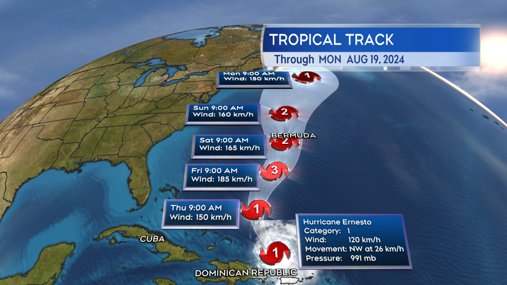
Ernesto gains hurricane strength, starts move northward towards Bermuda
The National Hurricane Center declared Ernesto a category-one hurricane with maximum sustained winds near the centre of the storm rated as 120 km/h on Wednesday.
The storm is moving northwest at 26 km/h and is entering a favourable area of the southern Atlantic for further strengthening.
The official forecast now has Ernesto reaching category-three – a major hurricane with maximum sustained winds near 185 km/h – Friday morning as it approaches the Bermuda area.
While it is too early to know if the storm will impact Bermuda directly, the agency states a Hurricane Watch may be issued for Bermuda by the end of the day.
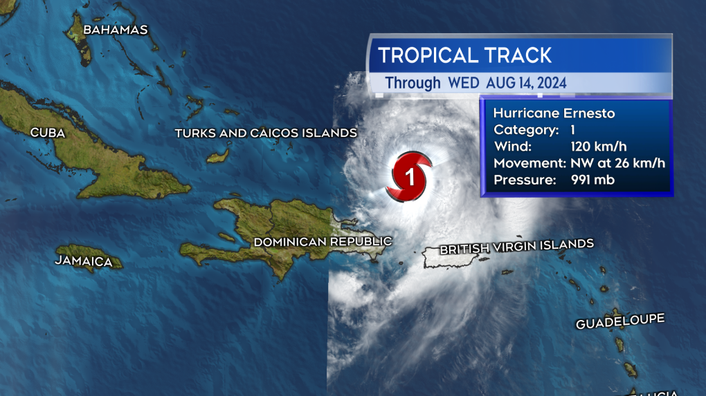 The current status of Ernesto per the noon ADT update from the NHC. (Source: CTV News Atlantic)
Forecast cone
The five-day forecast cone issued by the National Hurricane Center extends north of Bermuda and ends with it covering an area from Nova Scotia to well east of Sable Island Monday morning.
The cone is only issued for five days in advance, as beyond that time the uncertainty the storm will maintain a position within the cone becomes too great.
It has been found historically the track of the storm will remain within the forecast cone 60-to-70 per cent of the time.
 The forecast cone moves north of Bermuda and towards or east of the Maritimes. The cone widens to represent the growing uncertainty of the position of the storm moving further ahead in time. (Source: CTV News Atlantic)
A closer look at Atlantic Canada
The cone widens as the forecast for the storm extends from the current day through five days out. That is to express the increased uncertainty in the forecast as you move further away from the current day.
Being at the end of the five-day cone, the area it includes as it reaches Nova Scotia and east into the Atlantic is very wide – nearly 750 km/h wide.
Should the storm travel through the more western part of the cone (closer to Nova Scotia), it would increase the chances of weather impacts on land for the Maritimes on Monday.
A path more towards the central (Sable Island) or eastern part of the cone (Georges Bank and Scotian Slope marine districts) would decrease the chances of weather impacts on land for the Maritimes on Monday.
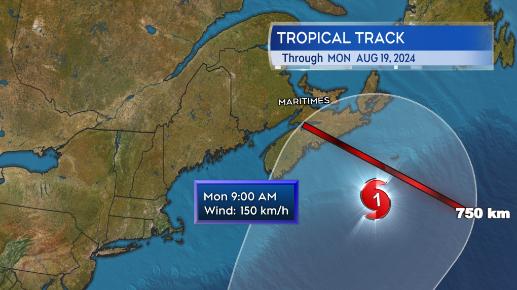 The cone is very broad as it reaches Nova Scotia for Monday. A path along the westernmost part of the cone would increase the chances of weather impacts, a path more central or eastern reducing the chance of weather impacts. (Source: CTV News Atlantic)
The forecast intensity of Ernesto as it approaches either Nova Scotia or the marine areas on Monday is a category-one hurricane with maximum sustained winds at 150 km/h.
While it is currently unknown if there will be a direct impact, category-one hurricanes are associated with:
- Damage to roof, shingles, vinyl siding, and gutters.
- Branch fall and possible toppling of shallowly rooted trees.
- Damage to power lines and poles that could result in outages from a few to several days
The Maritimes region is still very much in the long-range part of the forecast for Ernesto with all the increased uncertainty that comes with that. Be aware of the storm and check for updates daily, certainly on Friday. If you need help with making some preparations in the event of a hurricane, look for resources here.
Shopping Trends
The Shopping Trends team is independent of the journalists at CTV News. We may earn a commission when you use our links to shop. Read about us.


CTVNews.ca Top Stories

BREAKING
BREAKING Real GDP per capita declines for 6th consecutive quarter, household savings rise
Statistics Canada says the economy grew at an annualized pace of one per cent during the third quarter, in line with economists' expectations.
W5 Investigates
W5 Investigates A 'ticking time bomb': Inside Syria's toughest prison holding accused high-ranking ISIS members
In the last of a three-part investigation, W5's Avery Haines was given rare access to a Syrian prison, where thousands of accused high-ranking ISIS members are being held.
Class-action lawsuit on 'opioid-related wrongs': Court to rule on drug companies' appeal
Canada's top court will rule Friday on the appeal of a class-action lawsuit meant to recoup some of the costs associated with British Columbia's opioid crisis from major drug makers and distributors.
As Australia bans social media for children, Quebec is paying close attention
As Australia moves to ban social media for children under 16, Quebec is debating whether to follow suit.
Irregular sleep patterns may raise risk of heart attack and stroke, study suggests
Sleeping and waking up at different times is associated with an increased risk of heart attack and stroke, even for people who get the recommended amount of sleep, according to new research.
California man who went missing for 25 years found after sister sees his picture in the news
It’s a Thanksgiving miracle for one California family after a man who went missing in 1999 was found 25 years later when his sister saw a photo of him in an online article, authorities said.
Trudeau Liberals' two-month GST holiday bill passes the House, off to the Senate
The federal government's five-page piece of legislation to enact Prime Minister Justin Trudeau's promised two-month tax break on a range of consumer goods over the holidays passed in the House of Commons late Thursday.
Nick Cannon says he's seeking help for narcissistic personality disorder
Nick Cannon has spoken out about his recent diagnosis of narcissistic personality disorder, saying 'I need help.'
Notre Dame Cathedral: Sneak peek ahead of the reopening
After more than five years of frenetic reconstruction work, Notre Dame Cathedral showed its new self to the world Friday, with rebuilt soaring ceilings and creamy good-as-new stonework erasing somber memories of its devastating fire in 2019.
Toronto
-

Black Friday sales stretch out for weeks: retail analyst
Black Friday is officially the busiest shopping day of the year, even surpassing Boxing Day and Super Saturday, the final Saturday before Christmas. Analysts say retailers are rolling out Black Friday sales sooner now, making them last longer into Cyber Monday and beyond.
-
House fire in North York sends 6 people to hospital
Six people are in hospital as a precaution after a fire broke out in a North York home overnight.
-
50 cms of snow across central Ontario expected this weekend
Environment Canada has released snow squall warnings and watches for our region.
Calgary
-

Alberta will patrol shared border with Montana as tariff threat looms: premier
Alberta Premier Danielle Smith says the province is ready to take border security into its own hands.
-
Community concerned at lack of safety at Elbow Drive S.W. crossing
Meadowlark Park residents say a fatal crash involving a pedestrian on Wednesday night was just the latest incident at a very dangerous crossing.
-
Future of Sport in Canada commissioner invites more voices to consultations
The woman at the helm of the Future of Sport in Canada Commission says many Canadians have participated so far and she urges more to speak up.
Edmonton
-

Oilers rightly optimistic they can pull themselves into NHL playoff picture. Again
Hockey fans know the adage: U.S. Thanksgiving, while unofficial, serves as a great calendar marker in predicting which teams will make the National Hockey League playoffs.
-
Alberta will patrol shared border with Montana as tariff threat looms: premier
Alberta Premier Danielle Smith says the province is ready to take border security into its own hands.
-
Alberta taking federal government to court over revised impact assessment law
Alberta is taking the federal government to court, saying Ottawa has failed to follow through on what Premier Danielle Smith calls necessary changes to a law governing resource development.
Montreal
-

'Mayday!': New details emerge after Boeing plane makes emergency landing at Mirabel airport
New details suggest that there were communication issues between the pilots of a charter flight and the control tower at Montreal's Mirabel airport when a Boeing 737 made an emergency landing on Wednesday.
-
As Australia bans social media for children, Quebec is paying close attention
As Australia moves to ban social media for children under 16, Quebec is debating whether to follow suit.
-
Some Quebec daycares to open at 10 a.m. due to worker strike
For the third week in a row, some 3,000 workers at daycares in Quebec are expected go on strike for a few hours.
Ottawa
-

'Dude, Where's My Bus?' Ottawa man fed up with OC Transpo makes documentary exploring transit troubles
Gio Petti put together a documentary on OC Transpo, asking how we got here. How did a city that was once lauded as an example of how to do transit right, and that boasted some of the highest per capita transit ridership numbers in the country, become a system that now elicits so much frustration from users?
-
Ottawa to begin full enforcement of 3-item garbage limit on Monday: Here’s what you need to know
The City of Ottawa will begin the final phase of the graduated approach to enforcing the city’s new three-item garbage limit on Monday, leaving behind any extra items not in a yellow bag.
-
What's happening in Ottawa this weekend: Nov.29-Dec. 1
Santa Claus visits Ottawa and eastern Ontario, the Ottawa Black Bears play their first game and Christmas market season continues. CTVNewsOttawa.ca looks at things to do in Ottawa and eastern Ontario this weekend.
London
-

Knights' Boulton hit with eight-game suspension
The left winger has been suspended eight games, retroactive to Nov. 23 against Saginaw, when he was handed a major penalty for slashing, along with a game misconduct.
-
'Shock, disappointment, and excitement': South Bruce not selected for nuclear waste project
Anja Vandervlies and Michelle Stein could hardly believe it when they heard South Bruce was not going to host Canada’s first permanent storage facility for nuclear waste.
-
Dundas Place to be car-free more consistently with weekend schedule
City hall is once again considering changes to when Dundas Place transforms into a pedestrian-only street, but the city councillor representing Downtown London doesn’t think the time is right for scheduling weekly closures to traffic.
Barrie
-

50 cms of snow across central Ontario expected this weekend
Environment Canada has released snow squall warnings and watches for our region.
-
Individuals living in encampment in Barrie's south end given notice to vacate
Several police officers and city staff attended a homeless encampment in Barrie’s south end on Thursday morning to inform the individuals living there they would have to vacate the area.
-
Man convicted of violent sexual assault of a senior could be deemed dangerous offender
The Crown wants a Wasaga Beach man to be deemed a dangerous or long-term offender following a violent sexual assault of a senior inside her Stayner home two years ago.
Northern Ontario
-
Black Friday sales stretch out for weeks: retail analyst
Black Friday is officially the busiest shopping day of the year, even surpassing Boxing Day and Super Saturday, the final Saturday before Christmas. Analysts say retailers are rolling out Black Friday sales sooner now, making them last longer into Cyber Monday and beyond.
-
Northern Ontario site selected for nuclear waste underground repository
A region in northern Ontario has been chosen as the site to hold Canada's nuclear waste in a deep geological repository.
-
Ongoing bed bug issue at a Timmins apartment building is 'like living in hell'
A battle with bed bugs continues at 217 Pine St. North in Timmins, according to a tenant who has lived there for a year and a half.
Kitchener
-

One dead, another hurt in Cambridge shooting
Waterloo Regional Police are investigating a fatal shooting in Cambridge.
-
Mother from Guelph, Ont. seeks answers following son's death in prison
Brody Robinson was found without vital signs in his cell at Millhaven Institution the evening of Oct. 29. He was 23-years-old.
-
Flurries, possibly even snow squalls, in southern Ontario’s forecast
Winter finally arrives this week in southern Ontario. Environment Canada is forecasting flurries and snow squalls almost every day.
Windsor
-

Injury reported at NextStar Energy plant work site
The Ministry of Labour is investigating after an injury at the construction site of the NextStar Energy battery plant.
-
One man sought, one man arrested in kidnapping and extortion investigation
Windsor police officers have charged one man with 29 offences and they are seeking a second suspect in a kidnapping and extortion investigation.
-
Wrong-way driver arrested on E.C. Row Expressway
Windsor police say a 47-year-old man is facing impaired driving charges after going the wrong way on the E.C. Row Expressway.
Winnipeg
-

Hanover School Division laying off 93 EAs due to confusion over funding
The Hanover School Division is laying off 93 educational assistants, citing an "unexpected loss of federal funding for Jordan's Principle programming."
-
A tale of two downtowns: Restaurants opening and closing show complexity of downtown revival
Proposed developments and new businesses opening are fueling optimism for some on a revival of downtown Winnipeg, but some business owners say the present remains problematic.
-
Art auctioned from WAG-Qaumajuq to make way for new pieces representing Winnipeg
Visitors to the Winnipeg Art Gallery-Qaumajuq may soon see some brand new art hanging on its walls.
Regina
-

Extreme cold warning in effect for areas around Regina
Frigid temperatures and wind chills have prompted Environment and Climate Change Canada (ECCC) to issue an extreme cold warning for areas around Regina and other pats of southern and central Saskatchewan.
-
Crown gives final remarks in Ruben Manz case as argument to jury concludes
The prosecution has presented their closing remarks against Ruben Manz to a 13-person jury, bringing an end to arguments before their sequestering.
-
Youngest roping duo looking for repeat performance at Agribition Rodeo
Kavis Drake, 18, and Denim Ross, 20, won the average in last year’s Maple Leaf Finals Rodeo team roping event at Agribition. The two were the youngest competitors in 2023 and are once again in their event this year.
Saskatoon
-

Extreme cold warning issued for Saskatoon
Environment Canada has issued an extreme cold warning for parts of central Saskatchewan, including Saskatoon, on Thursday.
-
Sask. forecasting $743.5M deficit in mid-year financial report, up $470.5M from budget
The provincial government says increases to crop insurance claims later in the growing season are a main reason for Thursday’s mid-year deficit forecast of $743.5 million, which is up more than $470 million from the budget.
-
'Got to deal with it': Saskatoon residents dealing with bumpy, snowy roads
Most of the main roads in Saskatoon are cleared, but feeder streets and residential roads are a different story.
Vancouver
-

Could Vancouver's public funds be used for investments in cryptocurrency?
Vancouver Mayor Ken Sim has apparently expressed interest in cryptocurrency investments.
-
'Completely preventable': Wheel flies off dump truck on B.C. highway, striking SUV head-on
A dump truck driver has been handed more than $700 in fines after one of his wheels detached and flew into the front of an oncoming SUV in B.C.’s Fraser Valley on Thursday.
-
Suspect arrested in vandalism at Maple Ridge tea shop, RCMP say
Two months after a Maple Ridge tea shop was targeted in an alarming act of vandalism, authorities have identified a suspect.
Vancouver Island
-

Avian flu case discovered in Greater Victoria, officials confirm
The Canadian Food Inspection Agency (CFIA) has confirmed a case of avian flu has been detected in Greater Victoria, on the Saanich Peninsula.
-
Penelakut Island food stores spoil after power outage during B.C. windstorm
Hundreds of people on B.C.'s Penelakut Island are staring down a winter without their essential food stores.
-
Stolen Dodge pickup used in theft of 2nd Dodge truck, B.C. RCMP say
Authorities are asking for the public’s help tracking down at least two suspects who used a stolen Dodge pickup to steal a second Dodge truck in Greater Victoria this month.
Kelowna
-

Kelowna, B.C., to host the Memorial Cup in the spring of 2026
The Western Hockey League's Kelowna Rockets will host the Memorial Cup in the spring of 2026, the Canadian Hockey League said Wednesday.
-
545 vehicles impounded in 332 days: BC Highway Patrol pleads for drivers to slow down
Mounties with the BC Highway Patrol in Kelowna say they've impounded more than 545 vehicles for excessive speed and aggressive driving so far this year. That works out to more than 1.6 per day.
-
Man in hospital following targeted shooting in Kamloops
Police are appealing for information on a targeted shooting that resulted in the hospitalization of a man in Kamloops.


