Feels like fall in the Maritimes as Gulf states watch for another hurricane
The autumnal equinox occurred at 9:43 a.m. Sunday for the Maritimes, which was appropriate as a more typical “fall feel” returned to the air in contrast to the late summer heat of much of last week.
Fall feel
A persistent northeast wind cooled temperatures across the region Friday into the weekend.
Through much of this week high temperatures for the Maritimes will be closer to seasonable values, which is mostly high temperatures in the high-teens with some touching into the low-twenties. It’s cool enough Monday night into Tuesday morning (low temperatures for low-lying areas down to near 4 C) to give a chance of some patchy frost. Low temperatures will come up a few degrees for the remainder of the week, limiting the further risk of frost.
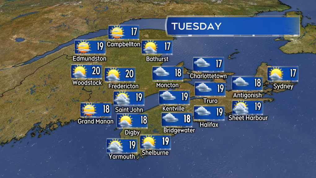 A seasonable, pleasant fall day ahead for Tuesday. A mix of sun and cloud along with high temperatures mostly in the range of 17 to 20 degrees. (Source: CTV News Atlantic)
Still dry, possible late week rain
A very minimal amount of rain was reported over the weekend, mostly in the form of some patchy showers and drizzle. Yarmouth and Shelburne counties in Nova Scotia picked up a bit more with two-to-four millimetres. It has been a very dry stretch of September weather for the Maritimes.
For those looking for more rain and showers, Thursday into Friday holds some potential. A low-pressure system and weather front is expected to move into the Maritimes from the west. The system would bring rain and showers to the region. This time of year, that type of weather system is usually good for 10-to-30 mm.
Hurricane expected in the Gulf of Mexico
An area of thunderstorms in the western Caribbean will move into the Gulf of Mexico on Wednesday.
The National Hurricane Center forecasts the storm will become a category-one and then category-two hurricane as it moves north across the Gulf. The current forecast cone favours a Thursday landfall in Florida somewhere between Choctawhatchee Bay on the panhandle and Tampa Bay as a category-two hurricane.
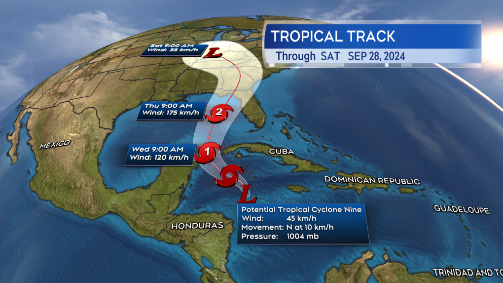 A tropical storm and then hurricane is expected to develop in the Gulf of Mexico and then approach Florida this week. (Source: CTV News Atlantic)
Aside from the risk of hurricane conditions for parts of Florida, as the storm comes onshore it could bring heavy rain to other states. States that could potentially get heavy rain include parts of Alabama, Georgia, South Carolina, and Tennessee. There are currently no indications the storm will have any direct impact on our weather in the Maritimes.
There is a second area of thunderstorms being monitored off the coast of Africa that is being given a 70 per cent chance of developing into a tropical system over the next seven days as it moves into the central Atlantic.
Shopping Trends
The Shopping Trends team is independent of the journalists at CTV News. We may earn a commission when you use our links to shop. Read about us.


CTVNews.ca Top Stories

W5 Investigates
W5 Investigates A 'ticking time bomb': Inside Syria's toughest prison holding accused high-ranking ISIS members
In the last of a three-part investigation, W5's Avery Haines was given rare access to a Syrian prison, where thousands of accused high-ranking ISIS members are being held.
Trudeau Liberals' two-month GST holiday bill passes the House, off to the Senate
The federal government's five-page piece of legislation to enact Prime Minister Justin Trudeau's promised two-month tax break on a range of consumer goods over the holidays passed in the House of Commons late Thursday.
Irregular sleep patterns may raise risk of heart attack and stroke, study suggests
Sleeping and waking up at different times is associated with an increased risk of heart attack and stroke, even for people who get the recommended amount of sleep, according to new research.
California man who went missing for 25 years found after sister sees his picture in the news
It’s a Thanksgiving miracle for one California family after a man who went missing in 1999 was found 25 years later when his sister saw a photo of him in an online article, authorities said.
As Australia bans social media for children, Quebec is paying close attention
As Australia moves to ban social media for children under 16, Quebec is debating whether to follow suit.
Notre Dame Cathedral: Sneak peak ahead of the reopening
After more than five years of frenetic reconstruction work, Notre Dame Cathedral showed its new self to the world Friday, with rebuilt soaring ceilings and creamy good-as-new stonework erasing somber memories of its devastating fire in 2019.
Canada Post temporarily laying off striking workers, union says
The union representing Canada Post workers says the Crown corporation has been laying off striking employees as the labour action by more than 55,000 workers approaches the two-week mark.
Can't resist Black Friday weekend deals? How to shop while staying within your budget
A budgeting expert says there are a number of ways shoppers can avoid getting enveloped by the sales frenzy and resist spending beyond their means.
Montreal shopping mall playing 'Baby Shark' song to prevent unhoused from loitering
A shopping mall and office complex in downtown Montreal is being criticized for using the popular children's song 'Baby Shark' to discourage unhoused people from loitering in its emergency exit stairwells.
Toronto
-

Video appears to show armed suspect attempting to carjack several drivers in Toronto's east end
Toronto police have released new details about a series of attempted carjackings and shootings that left one person seriously injured in Toronto’s east end on Wednesday night.
-
Ontario won't support making Truth and Reconciliation Day a holiday for now: minister
Premier Doug Ford's government will not support a New Democrat's bill to make the National Day for Truth and Reconciliation a statutory holiday in the province, the Indigenous affairs minister said Thursday.
-
Toronto woman injured after falling out of wheelchair provided by Air Canada, husband says
What could have possibly been Sheila Rizzuto’s last vacation ever was ruined after she fell out of an Air Canada-provided wheelchair and badly injured herself, according to her husband.
Calgary
-

Pedestrian killed after being hit by two vehicles while crossing Elbow Drive
Calgary police say a pedestrian was hit and killed while crossing Elbow Drive S.W. on Wednesday evening.
-
Alberta will patrol shared border with Montana as tariff threat looms: premier
Alberta Premier Danielle Smith says the province is ready to take border security into its own hands.
-
Consumers' choices thin, as are butchers' margins, with meat prices up
Many shoppers are avoiding expensive cuts or buying smaller quantities of meat.
Edmonton
-

Alberta will patrol shared border with Montana as tariff threat looms: premier
Alberta Premier Danielle Smith says the province is ready to take border security into its own hands.
-
'We want a negotiated contract': Local Canada Post workers remain steadfast as strike continues
Postal workers in Edmonton are holding their picket lines as the Canada Post strike nears its third week.
-
Canada Post temporarily laying off striking workers, union says
The union representing Canada Post workers says the Crown corporation has been laying off striking employees as the labour action by more than 55,000 workers approaches the two-week mark.
Montreal
-

'Mayday!': New details emerge after Boeing plane makes emergency landing at Mirabel airport
New details suggest that there were communication issues between the pilots of a charter flight and the control tower at Montreal's Mirabel airport when a Boeing 737 made an emergency landing on Wednesday.
-
As Australia bans social media for children, Quebec is paying close attention
As Australia moves to ban social media for children under 16, Quebec is debating whether to follow suit.
-
Some Quebec daycares to open at 10 a.m. due to worker strike
For the third week in a row, some 3,000 workers at daycares in Quebec are expected go on strike for a few hours.
Ottawa
-
 NEW THIS MORNING
NEW THIS MORNING Ottawa to begin full enforcement of 3-item garbage limit on Monday: Here’s what you need to know
The City of Ottawa will begin the final phase of the graduated approach to enforcing the city’s new three-item garbage limit on Monday, leaving behind any extra items not in a yellow bag.
-
'Dude, Where's My Bus?' Ottawa man fed up with OC Transpo makes documentary exploring transit troubles
Gio Petti put together a documentary on OC Transpo, asking how we got here. How did a city that was once lauded as an example of how to do transit right, and that boasted some of the highest per capita transit ridership numbers in the country, become a system that now elicits so much frustration from users?
-
NEW THIS MORNING
NEW THIS MORNING What's happening in Ottawa this weekend: Nov.29-Dec. 1
Santa Claus visits Ottawa and eastern Ontario, the Ottawa Black Bears play their first game and Christmas market season continues. CTVNewsOttawa.ca looks at things to do in Ottawa and eastern Ontario this weekend.
London
-

Dundas Place to be car-free more consistently with weekend schedule
City hall is once again considering changes to when Dundas Place transforms into a pedestrian-only street, but the city councillor representing Downtown London doesn’t think the time is right for scheduling weekly closures to traffic.
-
Knights blank Petes in Peterborough
Six different goal scorers found the back of the net for London, while goalie Alexei Medvedev made 31-saves for the shutout.
-
'Shock, disappointment, and excitement': South Bruce not selected for nuclear waste project
Anja Vandervlies and Michelle Stein could hardly believe it when they heard South Bruce was not going to host Canada’s first permanent storage facility for nuclear waste.
Barrie
-

50 cms of snow across central Ontario expected this weekend
Environment Canada has released snow squall warnings and watches for our region.
-
School bus cancellations by board
See current school bus cancellations by school board from across the region.
-
Individuals living in encampment in Barrie's south end given notice to vacate
Several police officers and city staff attended a homeless encampment in Barrie’s south end on Thursday morning to inform the individuals living there they would have to vacate the area.
Northern Ontario
-

Northern Ontario site selected for nuclear waste underground repository
A region in northern Ontario has been chosen as the site to hold Canada's nuclear waste in a deep geological repository.
-
Ongoing bed bug issue at a Timmins apartment building is 'like living in hell'
A battle with bed bugs continues at 217 Pine St. North in Timmins, according to a tenant who has lived there for a year and a half.
-
Sudbury family donates $1M to Health Sciences North Foundation
Di Brina Family Holdings announced Thursday it is donating $1 million to the Health Sciences North Foundation.
Kitchener
-

One dead, another hurt in Cambridge shooting
Waterloo Regional Police are investigating a fatal shooting in Cambridge.
-
Mother from Guelph, Ont. seeks answers following son's death in prison
Brody Robinson was found without vital signs in his cell at Millhaven Institution the evening of Oct. 29. He was 23-years-old.
-
Flurries, possibly even snow squalls, in southern Ontario’s forecast
Winter finally arrives this week in southern Ontario. Environment Canada is forecasting flurries and snow squalls almost every day.
Windsor
-

One man sought, one man arrested in kidnapping and extortion investigation
Windsor police officers have charged one man with 29 offences and they are seeking a second suspect in a kidnapping and extortion investigation.
-
Wrong-way driver arrested on E.C. Row Expressway
Windsor police say a 47-year-old man is facing impaired driving charges after going the wrong way on the E.C. Row Expressway.
-
Chatham-Kent passes 4.99% tax hike
Chatham-Kent approved a 4.99 per cent budget increase on Wednesday following two budget deliberation meetings. Based on the average household with an assessment value of $176,200, homeowners will pay an additional $176.
Winnipeg
-

Hanover School Division laying off 93 EAs due to confusion over funding
The Hanover School Division is laying off 93 educational assistants, citing an "unexpected loss of federal funding for Jordan's Principle programming."
-
A tale of two downtowns: Restaurants opening and closing show complexity of downtown revival
Proposed developments and new businesses opening are fueling optimism for some on a revival of downtown Winnipeg, but some business owners say the present remains problematic.
-
Art auctioned from WAG-Qaumajuq to make way for new pieces representing Winnipeg
Visitors to the Winnipeg Art Gallery-Qaumajuq may soon see some brand new art hanging on its walls.
Regina
-

Crown gives final remarks in Ruben Manz case as argument to jury concludes
The prosecution has presented their closing remarks against Ruben Manz to a 13-person jury, bringing an end to arguments before their sequestering.
-
Youngest roping duo looking for repeat performance at Agribition Rodeo
Kavis Drake, 18, and Denim Ross, 20, won the average in last year’s Maple Leaf Finals Rodeo team roping event at Agribition. The two were the youngest competitors in 2023 and are once again in their event this year.
-
Sentencing submissions presented in case of woman who defrauded Regina Mobile Crisis Services
The Crown and defence presented sentencing submissions at Saskatchewan Provincial Court on Thursday, in the case of a woman who pleaded guilty to defrauding Regina Mobile Crisis Services.
Saskatoon
-

Extreme cold warning issued for Saskatoon
Environment Canada has issued an extreme cold warning for parts of central Saskatchewan, including Saskatoon, on Thursday.
-
Sask. forecasting $743.5M deficit in mid-year financial report, up $470.5M from budget
The provincial government says increases to crop insurance claims later in the growing season are a main reason for Thursday’s mid-year deficit forecast of $743.5 million, which is up more than $470 million from the budget.
-
'Got to deal with it': Saskatoon residents dealing with bumpy, snowy roads
Most of the main roads in Saskatoon are cleared, but feeder streets and residential roads are a different story.
Vancouver
-

Could Vancouver's public funds be used for investments in cryptocurrency?
Vancouver Mayor Ken Sim has apparently expressed interest in cryptocurrency investments.
-
'Completely preventable': Wheel flies off dump truck on B.C. highway, striking SUV head-on
A dump truck driver has been handed more than $700 in fines after one of his wheels detached and flew into the front of an oncoming SUV in B.C.’s Fraser Valley on Thursday.
-
Suspect arrested in vandalism at Maple Ridge tea shop, RCMP say
Two months after a Maple Ridge tea shop was targeted in an alarming act of vandalism, authorities have identified a suspect.
Vancouver Island
-

Avian flu case discovered in Greater Victoria, officials confirm
The Canadian Food Inspection Agency (CFIA) has confirmed a case of avian flu has been detected in Greater Victoria, on the Saanich Peninsula.
-
Penelakut Island food stores spoil after power outage during B.C. windstorm
Hundreds of people on B.C.'s Penelakut Island are staring down a winter without their essential food stores.
-
Stolen Dodge pickup used in theft of 2nd Dodge truck, B.C. RCMP say
Authorities are asking for the public’s help tracking down at least two suspects who used a stolen Dodge pickup to steal a second Dodge truck in Greater Victoria this month.
Kelowna
-

Kelowna, B.C., to host the Memorial Cup in the spring of 2026
The Western Hockey League's Kelowna Rockets will host the Memorial Cup in the spring of 2026, the Canadian Hockey League said Wednesday.
-
545 vehicles impounded in 332 days: BC Highway Patrol pleads for drivers to slow down
Mounties with the BC Highway Patrol in Kelowna say they've impounded more than 545 vehicles for excessive speed and aggressive driving so far this year. That works out to more than 1.6 per day.
-
Man in hospital following targeted shooting in Kamloops
Police are appealing for information on a targeted shooting that resulted in the hospitalization of a man in Kamloops.


