Frost Advisories issued in New Brunswick; Tropical Storm Francine update
With high pressure moving in from the west, the sky will clear overnight in the Maritimes. It will be a crisp September night with a risk of frost for a few areas.
Frost Advisories
Clear night sky, light wind, and cool temperatures are part of the recipe for a risk of frost. That’s what is in the forecast for parts of northern and western New Brunswick overnight into early Wednesday morning. Low temperatures could fall into a range of zero-to-four degrees for some communities.
Environment Canada issued a Frost Advisory for Madawaska, Restigouche, Victoria, and Carleton counties as well as the Mount Carleton – Renous Highway area. Patchy frost is expected, especially for low-lying areas. The agency says people may wish to take measure to protect frost-sensitive plants.
There will be a lower risk of patchy frost for early Thursday morning in northern New Brunswick and a risk of frost through the end of the week and into the weekend.
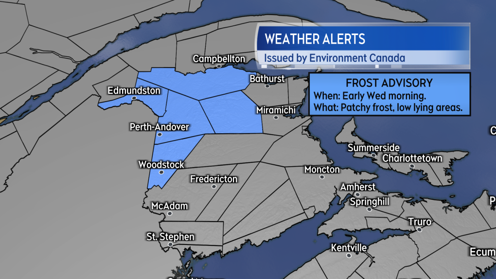 A Frost Advisory issued for parts of northern/western New Brunswick by Environment Canada. (Source: Environment Canada)
High pressure brings sunshine
Sunny September weather is expected both Wednesday and Thursday as a ridge of high pressure will extend out of the northeastern U.S. and across the Maritimes.
High temperatures will climb a few degrees on both days. High temperatures on Wednesday will range mostly 18-to-22 degrees across the Maritimes. High temperatures on Thursday will reach 24-to-27 C for New Brunswick, 21-to-25 C for Nova Scotia, and 20-to-22 C for Prince Edward Island.
High pressure shifts east and allows for a weak cold front to move out of Quebec and into the Maritimes Friday. The front will bring increased cloudiness and scattered showers across the region.
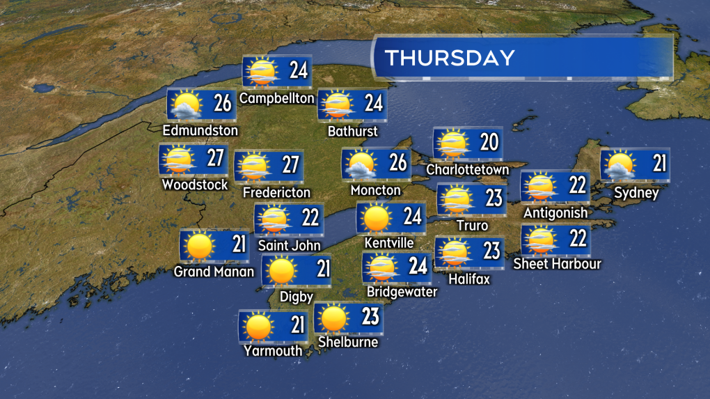 Mostly sunny and on the mild/warm side for September on Thursday. Especially for New Brunswick where some high temperatures could reach near 27 degrees. (Source: CTV News Atlantic)
Tropical Storm Francine
Tropical Storm Francine continues to move northward in the western area of the Gulf of Mexico.
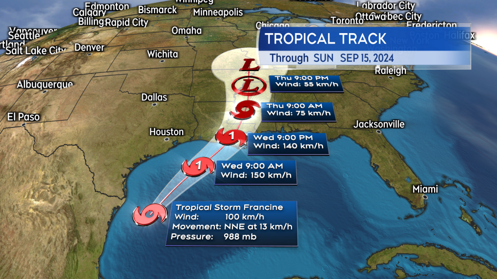 The Tuesday noon update for the forecast track and cone of Tropical Storm Francine. (Source: CTV News Atlantic)
The latest forecast from the National Hurricane Center has the storm becoming a strong category-one hurricane before making a landfall on the Louisiana coastline Friday. The location of landfall looks increasingly likely to be somewhere between West Cote Blanche Bay and Atchafalaya Bay to the west of New Orleans. Hurricane and Tropical Storm Warnings have been posted for the entire coastline of Louisiana.
The storm is expected to mostly dissipate in the southeastern United States. There remains little chance even the remnants would have any sort of impact to our weather in the Maritimes.
Shopping Trends
The Shopping Trends team is independent of the journalists at CTV News. We may earn a commission when you use our links to shop. Read about us.


CTVNews.ca Top Stories

W5 Investigates
W5 Investigates A 'ticking time bomb': Inside Syria's toughest prison holding accused high-ranking ISIS members
In the last of a three-part investigation, W5's Avery Haines was given rare access to a Syrian prison, where thousands of accused high-ranking ISIS members are being held.
'Mayday!': New details emerge after Boeing plane makes emergency landing at Mirabel airport
New details suggest that there were communication issues between the pilots of a charter flight and the control tower at Montreal's Mirabel airport when a Boeing 737 made an emergency landing on Wednesday.
Class-action lawsuit on 'opioid-related wrongs': Court to rule on drug companies' appeal
Canada's top court will rule Friday on the appeal of a class-action lawsuit meant to recoup some of the costs associated with British Columbia's opioid crisis from major drug makers and distributors.
Real GDP per capita declines for 6th consecutive quarter, household savings rise
Statistics Canada says the economy grew at an annualized pace of one per cent during the third quarter, in line with economists' expectations.
Cucumbers sold in Ontario, other provinces recalled over possible salmonella contamination
A U.S. company is recalling cucumbers sold in Ontario and other Canadian provinces due to possible salmonella contamination.
Irregular sleep patterns may raise risk of heart attack and stroke, study suggests
Sleeping and waking up at different times is associated with an increased risk of heart attack and stroke, even for people who get the recommended amount of sleep, according to new research.
Nick Cannon says he's seeking help for narcissistic personality disorder
Nick Cannon has spoken out about his recent diagnosis of narcissistic personality disorder, saying 'I need help.'
California man who went missing for 25 years found after sister sees his picture in the news
It’s a Thanksgiving miracle for one California family after a man who went missing in 1999 was found 25 years later when his sister saw a photo of him in an online article, authorities said.
As Australia bans social media for children, Quebec is paying close attention
As Australia moves to ban social media for children under 16, Quebec is debating whether to follow suit.
Toronto
-

Black Friday sales stretch out for weeks: retail analyst
Black Friday is officially the busiest shopping day of the year, even surpassing Boxing Day and Super Saturday, the final Saturday before Christmas. Analysts say retailers are rolling out Black Friday sales sooner now, making them last longer into Cyber Monday and beyond.
-
Cucumbers sold in Ontario, other provinces recalled over possible salmonella contamination
A U.S. company is recalling cucumbers sold in Ontario and other Canadian provinces due to possible salmonella contamination.
-
House fire in North York sends 6 people to hospital
Six people are in hospital as a precaution after a fire broke out in a North York home overnight.
Calgary
-

Multiple crashes reported on Deerfoot Trail
Calgary police say there are at least three major crashes on Deerfoot Trail on Friday morning as frigid overnight temperatures likely led to icy conditions in many areas.
-
Alberta will patrol shared border with Montana as tariff threat looms: premier
Alberta Premier Danielle Smith says the province is ready to take border security into its own hands.
-
Community concerned at lack of safety at Elbow Drive S.W. crossing
Meadowlark Park residents say a fatal crash involving a pedestrian on Wednesday night was just the latest incident at a very dangerous crossing.
Edmonton
-

Oilers rightly optimistic they can pull themselves into NHL playoff picture. Again
Hockey fans know the adage: U.S. Thanksgiving, while unofficial, serves as a great calendar marker in predicting which teams will make the National Hockey League playoffs.
-
Alberta will patrol shared border with Montana as tariff threat looms: premier
Alberta Premier Danielle Smith says the province is ready to take border security into its own hands.
-
Alberta taking federal government to court over revised impact assessment law
Alberta is taking the federal government to court, saying Ottawa has failed to follow through on what Premier Danielle Smith calls necessary changes to a law governing resource development.
Montreal
-

'Mayday!': New details emerge after Boeing plane makes emergency landing at Mirabel airport
New details suggest that there were communication issues between the pilots of a charter flight and the control tower at Montreal's Mirabel airport when a Boeing 737 made an emergency landing on Wednesday.
-
As Australia bans social media for children, Quebec is paying close attention
As Australia moves to ban social media for children under 16, Quebec is debating whether to follow suit.
-
Some Quebec daycares to open at 10 a.m. due to worker strike
For the third week in a row, some 3,000 workers at daycares in Quebec are expected go on strike for a few hours.
Ottawa
-

'Dude, Where's My Bus?' Ottawa man fed up with OC Transpo makes documentary exploring transit troubles
Gio Petti put together a documentary on OC Transpo, asking how we got here. How did a city that was once lauded as an example of how to do transit right, and that boasted some of the highest per capita transit ridership numbers in the country, become a system that now elicits so much frustration from users?
-
Ottawa to begin full enforcement of 3-item garbage limit on Monday: Here’s what you need to know
The City of Ottawa will begin the final phase of the graduated approach to enforcing the city’s new three-item garbage limit on Monday, leaving behind any extra items not in a yellow bag.
-
What's happening in Ottawa this weekend: Nov.29-Dec. 1
Santa Claus visits Ottawa and eastern Ontario, the Ottawa Black Bears play their first game and Christmas market season continues. CTVNewsOttawa.ca looks at things to do in Ottawa and eastern Ontario this weekend.
London
-

Knights' Boulton hit with eight-game suspension
The left winger has been suspended eight games, retroactive to Nov. 23 against Saginaw, when he was handed a major penalty for slashing, along with a game misconduct.
-
'Shock, disappointment, and excitement': South Bruce not selected for nuclear waste project
Anja Vandervlies and Michelle Stein could hardly believe it when they heard South Bruce was not going to host Canada’s first permanent storage facility for nuclear waste.
-
Dundas Place to be car-free more consistently with weekend schedule
City hall is once again considering changes to when Dundas Place transforms into a pedestrian-only street, but the city councillor representing Downtown London doesn’t think the time is right for scheduling weekly closures to traffic.
Barrie
-

50 cms of snow across central Ontario expected this weekend
Environment Canada has released snow squall warnings and watches for our region.
-
Individuals living in encampment in Barrie's south end given notice to vacate
Several police officers and city staff attended a homeless encampment in Barrie’s south end on Thursday morning to inform the individuals living there they would have to vacate the area.
-
Man convicted of violent sexual assault of a senior could be deemed dangerous offender
The Crown wants a Wasaga Beach man to be deemed a dangerous or long-term offender following a violent sexual assault of a senior inside her Stayner home two years ago.
Northern Ontario
-

Another 50 cm of snow possible in the Sault as severe weather continues
Closures and cancellations are piling up in Sault Ste. Marie as a major winter storm continues for another day Friday.
-
Ongoing bed bug issue at a Timmins apartment building is 'like living in hell'
A battle with bed bugs continues at 217 Pine St. North in Timmins, according to a tenant who has lived there for a year and a half.
-
California man who went missing for 25 years found after sister sees his picture in the news
It’s a Thanksgiving miracle for one California family after a man who went missing in 1999 was found 25 years later when his sister saw a photo of him in an online article, authorities said.
Kitchener
-

One dead, another hurt in Cambridge shooting
Waterloo Regional Police are investigating a fatal shooting in Cambridge.
-
Mother from Guelph, Ont. seeks answers following son's death in prison
Brody Robinson was found without vital signs in his cell at Millhaven Institution the evening of Oct. 29. He was 23-years-old.
-
Flurries, possibly even snow squalls, in southern Ontario’s forecast
Winter finally arrives this week in southern Ontario. Environment Canada is forecasting flurries and snow squalls almost every day.
Windsor
-

Injury reported at NextStar Energy plant work site
The Ministry of Labour is investigating after an injury at the construction site of the NextStar Energy battery plant.
-
One man sought, one man arrested in kidnapping and extortion investigation
Windsor police officers have charged one man with 29 offences and they are seeking a second suspect in a kidnapping and extortion investigation.
-
Wrong-way driver arrested on E.C. Row Expressway
Windsor police say a 47-year-old man is facing impaired driving charges after going the wrong way on the E.C. Row Expressway.
Winnipeg
-

Hanover School Division laying off 93 EAs due to confusion over funding
The Hanover School Division is laying off 93 educational assistants, citing an "unexpected loss of federal funding for Jordan's Principle programming."
-
A tale of two downtowns: Restaurants opening and closing show complexity of downtown revival
Proposed developments and new businesses opening are fueling optimism for some on a revival of downtown Winnipeg, but some business owners say the present remains problematic.
-
Winnipeg security company defrauded out of $72K: police
A pair of employees at a Winnipeg security company have been charged for their alleged involvement in payroll fraud.
Regina
-

Extreme cold warning in effect for areas around Regina
Frigid temperatures and wind chills have prompted Environment and Climate Change Canada (ECCC) to issue an extreme cold warning for areas around Regina and other pats of southern and central Saskatchewan.
-
Crown gives final remarks in Ruben Manz case as argument to jury concludes
The prosecution has presented their closing remarks against Ruben Manz to a 13-person jury, bringing an end to arguments before their sequestering.
-
Youngest roping duo looking for repeat performance at Agribition Rodeo
Kavis Drake, 18, and Denim Ross, 20, won the average in last year’s Maple Leaf Finals Rodeo team roping event at Agribition. The two were the youngest competitors in 2023 and are once again in their event this year.
Saskatoon
-

Ontario men arrested after Saskatoon police seize 16 kilos of meth, nearly $70K in cash
Saskatoon police say officers arrested three 20-year-old men Wednesday afternoon and seized nearly $70,000, in cash as well as various illicit drugs.
-
Extreme cold warning issued for Saskatoon
Environment Canada has issued an extreme cold warning for parts of central Saskatchewan, including Saskatoon, on Thursday.
-
Sask. forecasting $743.5M deficit in mid-year financial report, up $470.5M from budget
The provincial government says increases to crop insurance claims later in the growing season are a main reason for Thursday’s mid-year deficit forecast of $743.5 million, which is up more than $470 million from the budget.
Vancouver
-

Ex-mayor has no regrets as Surrey Police take over from RCMP after six-year saga
The Surrey Police Service took over from the RCMP and became the city's force of jurisdiction Friday, after a six-year saga set in motion by former mayor Doug McCallum.
-
Could Vancouver's public funds be used for investments in cryptocurrency?
Vancouver Mayor Ken Sim has apparently expressed interest in cryptocurrency investments.
-
Real GDP per capita declines for 6th consecutive quarter, household savings rise
Statistics Canada says the economy grew at an annualized pace of one per cent during the third quarter, in line with economists' expectations.
Vancouver Island
-

Avian flu case discovered in Greater Victoria, officials confirm
The Canadian Food Inspection Agency (CFIA) has confirmed a case of avian flu has been detected in Greater Victoria, on the Saanich Peninsula.
-
Real GDP per capita declines for 6th consecutive quarter, household savings rise
Statistics Canada says the economy grew at an annualized pace of one per cent during the third quarter, in line with economists' expectations.
-
Penelakut Island food stores spoil after power outage during B.C. windstorm
Hundreds of people on B.C.'s Penelakut Island are staring down a winter without their essential food stores.
Kelowna
-

Kelowna, B.C., to host the Memorial Cup in the spring of 2026
The Western Hockey League's Kelowna Rockets will host the Memorial Cup in the spring of 2026, the Canadian Hockey League said Wednesday.
-
545 vehicles impounded in 332 days: BC Highway Patrol pleads for drivers to slow down
Mounties with the BC Highway Patrol in Kelowna say they've impounded more than 545 vehicles for excessive speed and aggressive driving so far this year. That works out to more than 1.6 per day.
-
Man in hospital following targeted shooting in Kamloops
Police are appealing for information on a targeted shooting that resulted in the hospitalization of a man in Kamloops.


