Hurricane Milton approaches Florida; not expected to threaten Maritimes
Weather conditions will continue to deteriorate in Florida Wednesday evening and night as Hurricane Milton approaches and makes landfall. The eastward movement of the storm prevents it from becoming a risk for the Maritimes in the extended forecast.
Hurricane Milton larger and faster
The size of Hurricane Milton has increased from Tuesday into Wednesday. As the storm gets larger, the winds tend to diffuse more from the centre. Hurricane force winds are currently located about 100 km in diameter around the centre of the storm. This means hurricane and tropical storm force winds will arrive for parts of western Florida even before landfall.
The storm has also increased its speed towards the northeast since Tuesday. It is now moving at about 27 km/h. As of 2 p.m. ADT, the centre of the storm is located about 275 km to the southwest of Tampa, Florida.
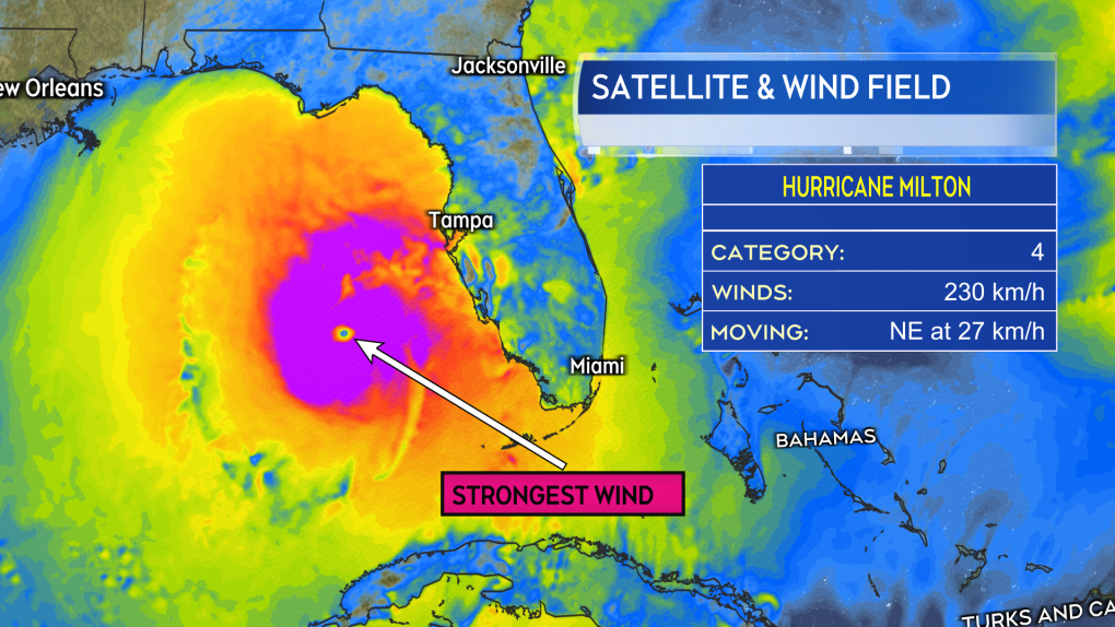 Hurricane and tropical storm force winds now cover a larger area as the storm has grown in size since Tuesday. The strongest winds in the southeastern quadrant of the eyewall. (Source: CTV News Atlantic)
Landfall and impacts
Based on the Wednesday noon bulletin from the National Hurricane Center, Hurricane Milton will make landfall in western Florida late Wednesday night.
The landfall looks like it will take place near midnight and to the south of Tampa, perhaps closer to Sarasota or Venice. The strength at landfall will be either a weak category-four or strong category-three hurricane. The area just south of the landfall point could face easterly winds gusting to 200-plus km/h. Tropical storm force winds will batter a much larger portion of the state Wednesday night into Thursday morning. The National Hurricane Centre notes the landfall position could still shift by 30 kilometres or so even this close in the forecast.
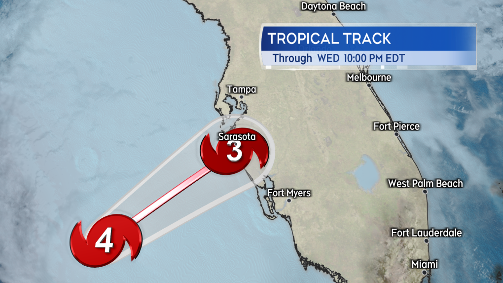 Landfall expected late Wednesday night in Florida. The centre forecast to move onshore to the south of the Tampa area. (Source: CTV News Atlantic)
The forecast for storm surge potential for Tampa could still approach 2.7 metres (eight feet), which would still be dangerous and life threatening. The storm surge potential is highest in areas to the south such as near Venice, Port Charlotte, and Boca Grande. Those areas are at risk of a storm surge that could approach or exceed three metres (10 feet or more).
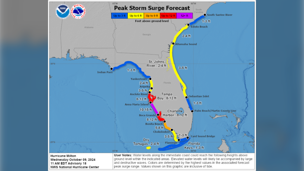 A peak storm surge map issued for Hurricane Milton by the National Hurricane Center.
The heaviest inland rain is still expected along and about 100 kilometres north of a line from Tampa to Orlando. Local rain totals could reach 150 to 450 mm and create flash and urban flooding. The outer bands of thunderstorms have already reached the state of Florida and have spawned instances of brief tornadoes. That weather already making last minute preparations and evacuations more difficult and dangerous in some areas.
Storm projected to move east past Bermuda
Milton is expected to exit eastern Florida into the Atlantic as a category-one hurricane Thursday morning. The storm is then expected to move east of Bermuda as a post-tropical area of low pressure by Saturday morning. The remnants of the storm will then start to slowly meander toward the north. A weather front coming across the Maritimes next Monday will likely keep the region clear of those remnants.
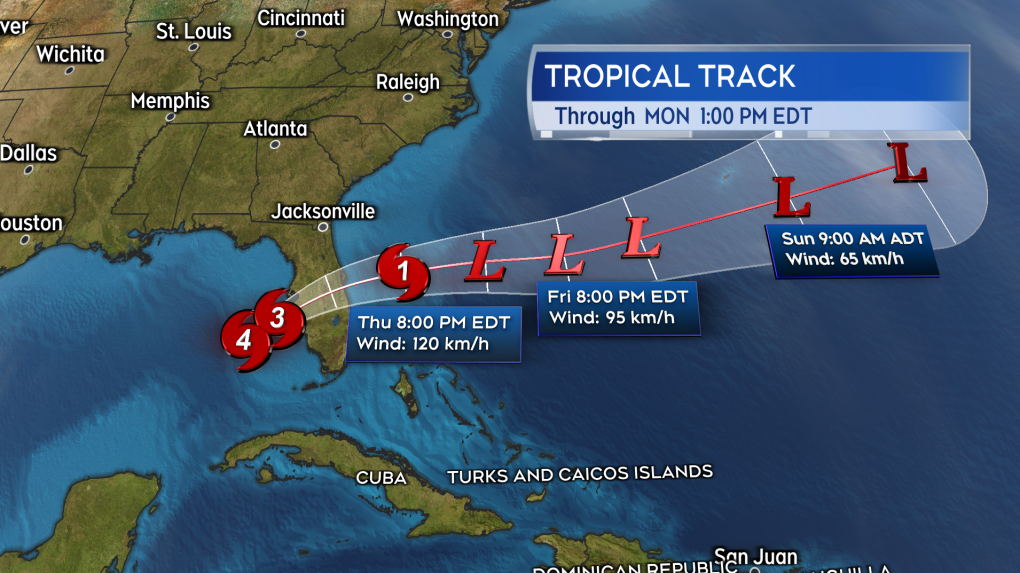 Milton is expected to continue east past Bermuda as a post-tropical storm. So far the remnants are expected to keep clear of the Maritimes. (Source: CTV News Atlantic)


CTVNews.ca Top Stories

From essential goods to common stocking stuffers, Trudeau offering Canadians temporary tax relief
Canadians will soon receive a temporary tax break on several items, along with a one-time $250 rebate, Prime Minister Justin Trudeau announced Thursday.
No evidence linking Modi to criminal activity in Canada: national security adviser
A senior official says the Canadian government is not aware of any evidence linking Indian Prime Minister Narendra Modi to alleged criminal activity perpetrated by Indian agents on Canadian soil.
Trump chooses Pam Bondi for attorney general pick after Gaetz withdraws
U.S. president-elect Donald Trump on Thursday named Pam Bondi, the former attorney general of Florida, to be U.S. attorney general just hours after his other choice, Matt Gaetz, withdrew his name from consideration.
Second Australian teen dies in tainted alcohol case in Laos that has killed 6 tourists
A second Australian teenager who fell critically ill after drinking tainted alcohol in Laos has died in a hospital in Bangkok, her family said Friday, bringing the death toll in the mass poisoning of foreign tourists to six.
A one-of-a-kind Royal Canadian Mint coin sells for more than $1.5M
A rare one-of-a-kind pure gold coin from the Royal Canadian Mint has sold for more than $1.5 million. The 99.99 per cent pure gold coin, named 'The Dance Screen (The Scream Too),' weighs a whopping 10 kilograms and surpassed the previous record for a coin offered at an auction in Canada.
Canoeist is paddling the 9,650-kilometre Great Loop out of gratitude for life
Peter Frank has paddled from Michigan's Upper Peninsula in June to the Chesapeake Bay in Maryland this month in his 1982 Sawyer Loon decked canoe, but he’s still got a long way to go.
More than 70K Murphy beds recalled across Canada, U.S. over tipping concerns
A popular series of Murphy beds that had been sold online is under a recall in Canada and the U.S. after several reported instances of the furniture detaching from walls.
She thought her children just had a cough or fever. A mother shares sons' experience with walking pneumonia
A mother shares with CTVNews.ca her family's health scare as medical experts say cases of the disease and other respiratory illnesses have surged, filling up emergency departments nationwide.
Meta fights CRTC, refuses to publicly release info on news blocking measures
Meta is refusing to publicly disclose information that could determine whether it is subject to the Online News Act despite blocking news from its platforms.
Shopping Trends
The Shopping Trends team is independent of the journalists at CTV News. We may earn a commission when you use our links to shop. Read about us.


Toronto
-

'Not good for the economy': MPs call on federal government to regulate resale concert tickets
Ticket fraud and sky-high prices for Taylor Swift concerts have some politicians calling for changes to the way tickets are sold in Canada.
-
Toronto Santa Claus Parade organizers 'optimistic' after funding comes in for 2025 event
The organizers of Toronto’s Original Santa Claus Parade are hopeful that the Jolly Old Elf will be coming to town for years to come.
-
North York shooting sends man to hospital
A man has been rushed to the hospital following a shooting in North York Thursday night.
Calgary
-

Calgary Fire Department responding to explosion in Mahogany
The Calgary Fire Department responded to an explosion and fire at a six-plex in the city's southeast on Thursday afternoon.
-
A tax break and cut cheques: Ottawa announces relief plan for cash-strapped Canadians
It's an announcement meant to appeal to cash-strapped Canadians—a tax break impacting everything from groceries to children's clothes to diapers—and it will last for two months.
-
'It was horrendous': Calgary family traumatized after vicious dog attack in northwest
A Calgary family is warning others and wants to see more accountability for pet owners after their dog was attacked and seriously injured in the northwest community of Royal Oak.
Edmonton
-

Alberta pitches new rules for auto insurance, including rate hikes, no-fault claims
The Alberta government is making changes to auto insurance, including rate hikes and switching to a predominantly no-fault claims model.
-
Cartmell, Caterina running to be Edmonton's next mayor
Two city councillors, one sitting and one former, will be running for mayor in 2025.
-
A tax break and cut cheques: Ottawa announces relief plan for cash-strapped Canadians
It's an announcement meant to appeal to cash-strapped Canadians—a tax break impacting everything from groceries to children's clothes to diapers—and it will last for two months.
Montreal
-

Montreal says no to water fluoridation
Lachine Mayor and member of Projet Montreal Maja Vodanovic said the city will not reopen the debate on water fluoridation.
-
2 men arrested after man stabbed in Milton Park
A 46-year-old man is recovering in the hospital after he was stabbed in the Milton Park neighbourhood of Montreal on Thursday night.
-
Pro-Palestinian protesters gathered outside Concordia University amid Quebec-wide boycotts
The lobby of Concordia University’s Hall Building was flooded with pro-Palestinian protesters Thursday as others gathered and chanted outside the campus as part of Quebec-wide solidarity strikes.
Ottawa
-
 NEW THIS MORNING
NEW THIS MORNING What's happening in Ottawa this weekend: Nov.22-24
Santa Claus visits Kanata, Kingston and Arnprior, Christmas market season gets underway and the Vanier Cup is at Queen’s University. CTVNewsOttawa.ca looks at things to do in Ottawa and eastern Ontario this weekend.
-
uOttawa to reconsider participation in U-Pass if city increases student fares, student union says
The student union at the University of Ottawa says it will consider pulling its participation from the U-Pass, which provides discounted transit fares for students, if the city goes forward with hiking student transit fees and violating the program’s contract.
-
Abdi inquest: Arresting officer feared for his safety during deadly arrest, jurors hear
A former Ottawa police officer returned to the witness stand on Monday and provided further details of the moments before the violent and deadly arrest of Abdirahman Abdi on the fourth day of a coroner's inquest into the circumstances of his death.
London
-

One person dead after two-vehicle crash involving delivery truck
Emergency crews were called to the scene on Highway 10 around 9 a.m. for reports of a crash between a van and a delivery truck.
-
Budget Day 1: Council holds the line on 7.4% tax rate increase but funds shelter beds and more park maintenance
The first day of 2025 Budget deliberations at city hall saw a pair of high-priced programs supported by council – but only after finding ways to keep the cost off property tax bills.
-
London man arrested after attempting to break into a home, threatening residents
Police say that on Thursday, November 21 between the hours of 1:30 a.m., and 4:30 a.m. the suspect came and went from a residence on Conway Drive.
Barrie
-

First university campus coming to Barrie
Just weeks after endorsing a plan set to bring a new sports field to the downtown core, there's another major shakeup on the horizon.
-
'You can't be lazy on my watch,' Court hears audio recordings in trial of alleged traffickers
The Crown played audio recordings in a Barrie courtroom Thursday afternoon that provided a glimpse into the lives of alleged human traffickers Lauriston and Amber Maloney and the group of young women who lived and worked for them.
-
Is your home safe? Experts warn odourless radioactive gas can cause lung cancer
Radon is the second leading cause of lung cancer in Canada, according to Grey Bruce Public Health Unit (GBPH).
Northern Ontario
-

Province cancels deal with Canadore College for North Bay addiction treatment centre
After years of delays, the province has pulled the plug on an addiction treatment centre in North Bay. A news release from Canadore College on Thursday confirmed the centre won’t be moving forward.
-
From essential goods to common stocking stuffers, Trudeau offering Canadians temporary tax relief
Canadians will soon receive a temporary tax break on several items, along with a one-time $250 rebate, Prime Minister Justin Trudeau announced Thursday.
-
$3M donation to help repair arena in Elliot Lake
The City of Elliot Lake said Thursday it has received a $3-million donation from Edward and Suzanne Rogers for the Centennial Arena restoration.
Kitchener
-

LRT train knocked off its tracks after slamming into car
A crash between an LRT train and car shut down a busy Kitchener street for more than eight hours on Thursday.
-
FunGuyz says it's closing all 30 of its magic mushroom stores in Ontario
FunGuyz, which calls itself the biggest magic mushroom dispensary in Canada, says it's shutting down all 30 of its Ontario locations.
-
Fight between rival motorcycle gangs in Cambridge leads to five arrests, more than a dozen charges
A fight between rival outlaw motorcycle gangs has led to multiple arrests, more than a dozen charges and the seizure of 17 firearms.
Windsor
-

Ont. law firm seeks information on convicted Catholic priest amid active abuse lawsuit
An Ontario law firm is seeking information about the movements and activities of a Catholic priest who was convicted of sexually abusing a 12-year-old boy before he died.
-
Woman sought following serious assault in west Windsor
Windsor police are asking for the public’s help identifying a suspect wanted in connection to an alleged serious assault that happened this past summer.
-
Sparky's Toy Drive on the hunt for a new home
They’ve been based out of the basement of Hotel Dieu Grace Healthcare for many years, rent free - however, that partnership is coming to an end.
Winnipeg
-

Sio Silica plans to try again with controversial project in Manitoba
Sio Silica is planning to try again with a controversial mining project in the same spot using the same method that the province rejected less than a year ago, but this time with more community engagement.
-
'We need new revenue': Winnipeg projecting operating shortfall by end of 2024
The City of Winnipeg is projecting an operating shortfall in 2024, and the plan to cover it off would completely drain the city's rainy day fund.
-
Manitoba RCMP issue Canada-wide warrant for Ontario semi-driver charged in deadly crash
Manitoba RCMP have issued a Canada-wide arrest warrant for the semi-driver involved in a crash that killed an eight-year-old girl and her mother.
Regina
-

Accused of sexual assault, Regina chiropractor takes the stand as first defense witness
A Regina chiropractor accused of sexually assaulting seven different women took the stand Thursday as arguments began in his defense.
-
Contractor fatally injured while on the job at Regina's Evraz plant
Evraz North America says an investigation is underway after a contractor was fatally injured while on the job in Regina on Nov. 19.
-
'I'll always be a Pat': Regina Pats trade captain Tanner Howe to Calgary
The Regina Pats have announced a blockbuster trade Thursday that sees captain Tanner Howe on his way to Calgary to play for the Hitmen as the team continues rebuilding for the future.
Saskatoon
-

Sask. principal has sexual assault conviction overturned in light of 'butt-grabbing game'
A Saskatchewan principal convicted to six months behind bars for sexual assault has another chance to prove he’s the victim of a middle-school prank that escalated out of control.
-
Saskatoon's first female mayor sworn in
After being sworn in Wednesday night alongside a mix of new and returning city councillors, Cynthia Block becomes the first female mayor of Saskatoon.
-
Sask. tuxedo business closes stores across the province
A Saskatchewan tuxedo business says struggles with inflation and operating costs have caused it close stores across the province.
Vancouver
-

Vancouver police ignore FOI requests for chief's communications
For nearly a year, the Vancouver Police Department has failed to fulfill two freedom of information requests seeking records from Chief Adam Palmer and other high-ranking officials – a situation transparency advocates call highly concerning, and potentially illegal.
-
B.C. Conservatives roll out shadow cabinet and leadership roles for all 44 caucus members
All 44 members of the B.C. Conservative caucus have been appointed to leadership positions – whether as shadow cabinet members or Opposition house leader.
-
Vancouver youth soccer coach says racism complaint went uninvestigated for a year
The coach of a soccer team in the Vancouver Youth Soccer Association claims a complaint about racism directed at 13-year-old players on his team went unaddressed for more than a year.
Vancouver Island
-

Major crime investigators reviewing death of Victoria teen, which coroner reclassified as homicide
Vancouver Island’s major crime unit is investigating the case of a Victoria teenager whose death was initially ruled an accidental overdose, but has since been reclassified by coroners as a homicide.
-
B.C. Conservatives roll out shadow cabinet and leadership roles for all 44 caucus members
All 44 members of the B.C. Conservative caucus have been appointed to leadership positions – whether as shadow cabinet members or Opposition house leader.
-
1 dead after Nanaimo house fire, RCMP say
One person is dead after a fire that destroyed a home in Nanaimo's south end Wednesday morning.
Kelowna
-

Man in hospital following targeted shooting in Kamloops
Police are appealing for information on a targeted shooting that resulted in the hospitalization of a man in Kamloops.
-
Police cleared of fault in fatal 2023 crash in B.C.'s Interior
British Columbia's independent police watchdog has cleared officers of wrongdoing in a crash where three people were killed south of Kamloops in July of last year.
-
B.C. woman sentenced for stealing $14K in funds raised for schoolkids
A B.C. woman who stole more than $14,000 in volunteer-raised funds that were supposed to be spent on school supplies and programs – including hot meals for vulnerable kids – won't spend any time in jail.


