Snow totals of 20 to near 50 cm reported in N.S. from Tuesday storm
 Corrine Penney gets set to shovel snow early Wednesday, Feb. 14, 2023 in Sydney, N.S. Winter storm warnings remain in effect for parts of Nova Scotia and much of Newfoundland and Labrador as a large snowstorm continues to trudge across Atlantic Canada. (Source: THE CANADIAN PRESS/Steve Wadden)
Initial snow reports from Environment Canada-monitored weather stations and volunteers from the CoCoRaHS network show the heaviest snow from the passing storm fell towards Atlantic coastal Nova Scotia.
A widespread 20 to just over 30 centimetres reported from Tusket all the way up through Halifax and to Sydney. The highest snow report so far was from a volunteer at Spanish Ship Bay with 52 centimetres of snow. The snow was of the “fluffy” variety with a snow ratio of about 15:1. That means every 15 millimetre of snow melts down to about 1 millimetre of liquid. A “standard” snow has a ratio of about 10:1, a heavy wet snow a ration of 8:1 or lower.
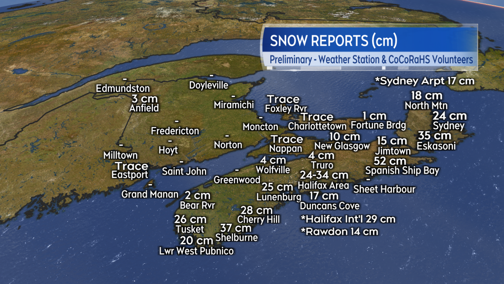 Preliminary snow reports from weather stations and the network of volunteers at CoCoRaHS. (Source: CTV News Atlantic)
Intense snowfall rates
A significant contributor to the high snow totals was a narrow but intense band that moved in off the Atlantic. While only about 10-to-20 kilometres across, it was able to produce snowfall rates of three-to-five centimetres for at least a couple of hours for those areas that picked up the most snow.
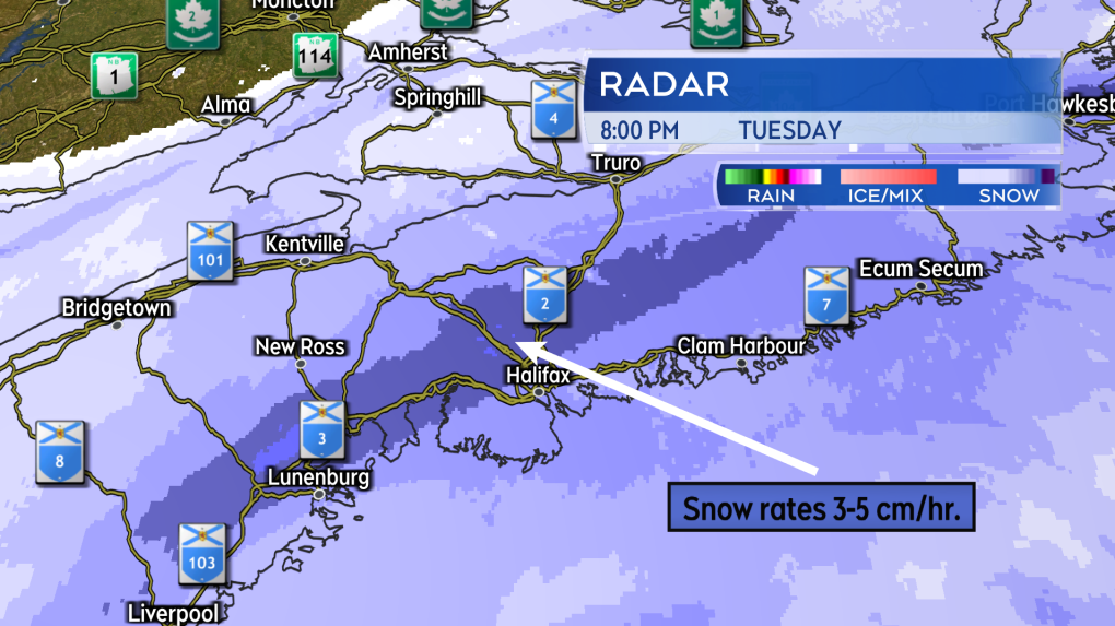 The narrow but intense band of snow that setup over the Atlantic coastal communities of Nova Scotia Tuesday evening. (Source: CTV News Atlantic)
That narrow band of intense snow first arrived on the South Shore and into the Halifax area Tuesday evening.
The band then pulled east of those areas but continued across the Eastern Shore and Richmond/Cape Breton Counties. The band finally clearing Cape Breton by near 7 a.m. Wednesday morning.
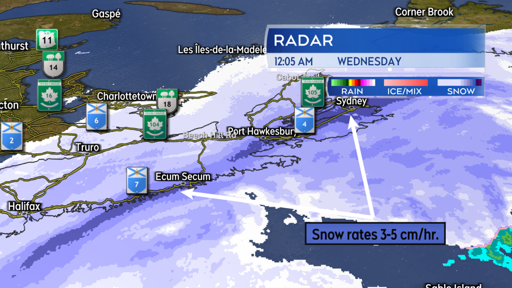 The same band of intense snow stretched across the Eastern Shore and into Cape Breton. (Source: CTV News Atlantic)
Snow squalls follow
The storm has moved on to impact eastern Newfoundland squarely on Wednesday. Much of the eastern portion of that province is under a Winter Storm Warning with some areas expected to pick up 60 centimetres or more of snow. That part of Atlantic Canada is also catching the strongest winds from the storm with some peak winds reported in excess of 90 km/h.
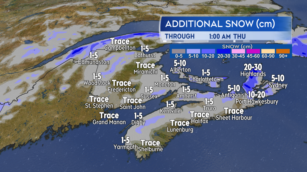 Flurries and snow squalls brought in by a cold and gusty northwest wind will provide further localized snow accumulation Wednesday night into Thursday morning. (Source: CTV News Atlantic)
A cold and gusty northwest wind has set up for the Maritimes in the wake of the storm. As that northwest wind blows over the Bay of Fundy, Northumberland Strait, and Gulf of St. Lawrence, it is expected to bring flurries and snow squalls onshore.
The snow squalls will intensify Wednesday evening and night. They pose the most risk for eastern Prince Edward Island as well as Pictou, Antigonish, Inverness, and Victoria counties in eastern Nova Scotia. Some of the squalls for those areas could produce localized amounts of five-to-15 centimetres. More than 30 centimetres are possible in the higher terrain of the Cape Breton Highlands. Flurries in other parts of the Maritimes are generally expected to total one-to-five centimetres.
The flurries and snow squalls are expected to diminish and end by and through Thursday morning. The gusty northwest wind will ease Thursday evening and night.
CTVNews.ca Top Stories

India's 'most wanted terrorist' arrested on gun charges in Canada
One of India's most wanted terrorists has been arrested and charged in connection with a recent alleged shooting in Ontario.
12-year-old boy charged in stabbing of 11-year-old boy at Edmonton McDonald's
The boy stabbed at a north Edmonton McDonald's last Friday is 11 years old.
What makes walking so great for your health and what else you need to do
Medical experts agree that walking is an easy way to improve physical and mental health, bolster fitness and prevent disease. While it’s not the only sort of exercise people should do, it’s a great first step toward a healthy life.
U.S. Congress hosts second round of UFO hearings
The U.S. government held another UFO hearing on Capitol Hill on Wednesday, the second such hearing in 16 months. This hearing was billed as an attempt by congress to provide a better understanding of what is known about previous sightings of UFOs, also known as UAPs (Unidentified Anomalous Phenomena).
Toronto teenager charged with first-degree murder in Kitchener, Ont. homicide
A Toronto teen has been charged as part of an investigation into Kitchener, Ont.’s first homicide of 2024.
Spy service officer denies threatening Montreal man who was later imprisoned in Sudan
A Canadian Security Intelligence Service official has denied threatening a Montreal man who was later imprisoned and allegedly tortured by authorities in Sudan.
Donald Trump picks Florida Rep. Matt Gaetz to serve as attorney general
President-elect Donald Trump on Wednesday said he will nominate Republican Rep. Matt Gaetz of Florida to serve as his attorney general, putting a loyalist in the role of the nation's top prosecutor.
This Canadian airline will adopt Apple's new AirTag feature to help recover lost baggage. Here's how
Apple announced that a new feature, 'Share Item Location,' will help users locate and recover misplaced items by sharing an AirTag location with third parties including airlines.
Canada bracing for 'tough' talks as Trump's pick calls northern border an 'extreme vulnerability'
The Canadian government is aware it's likely in for 'tough conversations' with U.S. president-elect Donald Trump's administration, after his border czar said there is 'an extreme national security vulnerability' he intends to tackle at the Canada-U.S. border.


