
A one-two punch of weather systems move across the Maritimes at the end of this week.
Tropical depression Erin, the fifth named storm of the Atlantic hurricane season, will move in from the south Thursday morning meeting up and merging with a cold front arriving from the west. At first moisture will be drawn off Erin and towards the cold front. This happens early Thursday morning with rain beginning in western areas of New Brunswick and southwest of Nova Scotia before sunrise. The rain spreads quickly across New Brunswick and mainland Nova Scotia morning into early afternoon. In the late afternoon and evening, the rain will reach Prince Edward Island and Cape Breton.
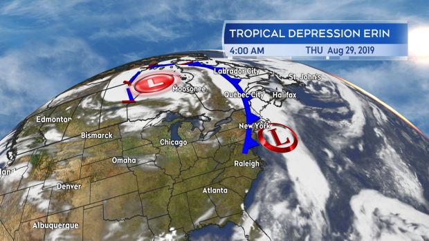
Tropical Depression Erin will merge with a cold front over the Maritimes Thursday into Friday.
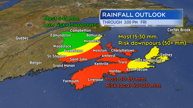
Much of the rain during the day on Thursday will be light to moderate. As the remnants of Erin approach the Atlantic coastline of Nova Scotia on Thursday evening and night, downpours will develop. These downpours are most likely for southern areas of New Brunswick, P.E.I., and western Nova Scotia. The downpours clear through most areas by early Friday morning with Cape Breton the last to clear the rain which could hold on up until near noon. Rainfall totals for much of the region will range 30 to 60 mm with lower amounts in northern New Brunswick and eastern Nova Scotia. Areas that see multiple downpours chain through could see local amounts of 60 to 100 mm.
Higher rainfall rates produced by tropical moisture do increase the risk of flooding and flash flooding. Those types of standing water issues are most likely Thursday evening and night.
Rain and downpours clear most of the Maritimes by or near sunrise on Friday. P.E.I. and eastern areas of Nova Scotia may take until 10 a.m. for the rain to clear. Cape Breton could see some rain hold on until near noon.
While this is needed rain, areas of the Maritimes will be at risk of flooding issues as the tropical moisture fuels downpours.
Winds will be from the south and southeast Thursday increasing to include gusts of 30 to 50 km/h by the afternoon. During Thursday evening and night these winds will increase to include gusts of 40 to 70 km/h. Gusts for Inverness County, Cape Breton will exceed 90 km/h Friday morning due to the topography of the Highlands. Winds will gradually diminish through Friday morning and afternoon as well as turn westerly. The winds are expected to remain below warning criteria but the gusts in combination with the heavy rain and full foliage may cause some weaker branches or trees to come down. Should those impact powerlines, some power outages would result. Areas where this is most likely are those also at risk of seeing the heaviest rain which again includes southern New Brunswick, P.E.I., and western Nova Scotia.
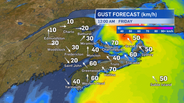
Gusts will peak 40 to 70 km/h out of the south and southeast Thursday evening and night. Diminishing Friday morning and afternoon.
There will be no risk of a flooding storm surge from this weather system. Surf is expected to be rougher than normal Thursday evening, night, and Friday morning so those working or enjoying recreation on coasts and wharves should exercise more caution during that time.


