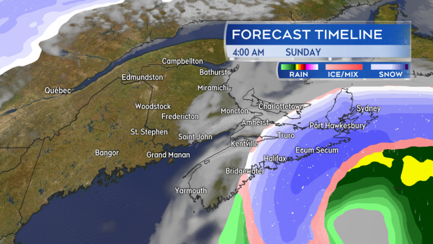
HALIFAX -- A low pressure system moving out of the northeastern United States will swing south and east of the Atlantic coastline of Nova Scotia late Saturday into Sunday. As it passes it looks likely to bring some bands of heavy, wet snow off the Atlantic into eastern areas of that province as well as some high and gusty winds.
The system starts with showers and flurries developing in western Nova Scotia Saturday afternoon. That continues into the evening with little expected in the way of snow accumulation. By midnight, Saturday into Sunday, heavier snow is expected to develop across the Eastern and North Shores of mainland Nova Scotia as well as Cape Breton. That heavier snow will then continue into Sunday morning before clearing through Sunday afternoon.

Heavy bands of snow could wrap in off the Atlantic ocean into eastern areas of Nova Scotia Saturday night and into Sunday
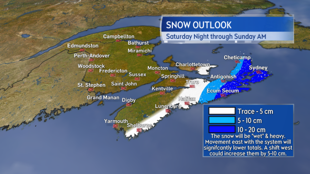
The snow will be "wet" by nature making it heavy with significant melting and compaction on the ground. That said, there is the potential of some fairly widespread amounts of 10 to 20 cm in eastern Nova Scotia. A shift east with the system, further out into the Atlantic, would significantly reduce the snowfall where as a movement west would increase it. I would highly recommend that if you are located in the eastern area of Nova Scotia that you check for updates on the forecast at least once Saturday morning and then again in the afternoon.

Although likely to be "wet" and heavy some widespread amounts of 10 to 20 cm would be possible for parts of Cape Breton and eastern mainland N.S.
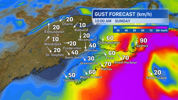
The central pressure of the low will continue to fall as it passes by the coastline of Nova Scotia resulting in the development of some stronger northerly winds. Coastal areas beginning near Halifax and running all the way to Sydney can expect some gusts peaking between 60-90 km/h to develop for Sunday morning. The strong gusts will ease for the mainland Sunday afternoon and Sunday evening for Cape Breton.

Northerly winds will increase along the Atlantic coastline of Nova Scotia for Sunday morning and afternoon.
Takeaways:
- A strong coastal low will pass south and east of Nova Scotia late Saturday into Sunday.
- A heavy April snowfall is likely for eastern areas of the province Saturday night through Sunday morning.
- Northerly winds will increase for Sunday morning with gusts along the coastline of 70 to 90 km/h Halifax to Sydney.
- A shift east of the system will significantly lower expected snowfall. A movement west will increase it.
- Very little impact is expected at this time for New Brunswick and Prince Edward Island.


