If you’ve been watching the news this week, you’ve probably heard the term polar vortex referenced regarding some exceptionally cold temperatures expected for areas of North America.
So what is the polar vortex? The polar vortex is a semi-permanent area of low pressure under which is contained exceptionally cold Arctic air. “Polar” for its typical position near the North Pole and “vortex” for the counter-clockwise motion that all low-pressure systems induce in the atmosphere in the Northern Hemisphere. The term dates back to 1853 in its use in the field of meteorology.
For much of the year, the polar vortex is contained within the Arctic Circle. Occasionally (and most frequently during our winter season) the polar vortex becomes unstable and breaks into waves of cold Arctic-source air that can dip down south and move across more southern areas of North America. One of these waves of cold Arctic air is currently moving across and impacting areas of Canada and the United States. Through the start of this week it broke down and south through Saskatchewan and Manitoba into Ontario and the mid-western U.S. Through the end of this week and weekend it will traverse Quebec, Labrador, and eventually moderate over the ocean waters of the North Atlantic next week.
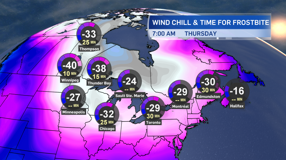
While this does happen during our winter season, this particular episode is more extreme than typical. It has resulted in dangerous wind chills making it feel close to -50 for areas of Saskatchewan and Manitoba on Wednesday and a large swath of extreme cold warnings for central and Eastern Canada. Those types of wind chills can create frostbite in five minutes or less to exposed skin. It also set new low temperature records for parts of Central Canada and the mid-western U.S. The coldest temperature in Canada on Wednesday was at Key Lake, Sask., at -47.2 C, beating out even much more northern locations such as Shepard Bay, NU, (-44.7 C) and Hanbury River, NT, (-43.3 C).
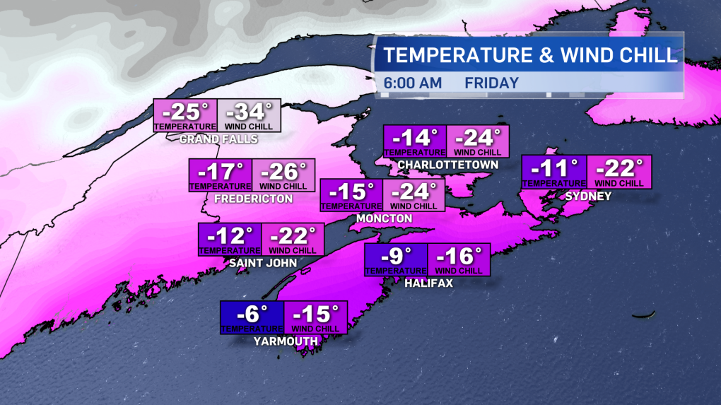
The Maritimes will be impacted by this breakdown in the polar vortex later this week and into the weekend. It will be more of a brush-past than a direct hit for us, though it will get plenty cold as the Arctic-sourced air moves in. Northern New Brunswick will catch the brunt of it with temperatures well down into the minus teens and 20s Thursday night. The wind chill will make it feel closer to -30 C on Friday morning. Wind chills in other areas of the Maritimes will make it feel into the minus teens and 20s at times Thursday through Sunday.
The cold air will began to moderate substantially on Monday and Tuesday.
