Powerful Hurricane Earl forecasted to pass east of Maritimes

Hurricane Earl has increased in strength to become a category two hurricane with maximum sustained winds in the eye of the storm near 165 km/h as it moves to a position 365 kilometres south of Bermuda Thursday.
The hurricane is entering an environment of warm ocean water temperatures and light wind shear which will allow it to continue to intensify. The latest forecast from the National Hurricane Center has Earl reaching category three as early as Thursday evening and category four with maximum sustained winds near 215 km/h as early as Friday evening as it moves northeast of Bermuda.
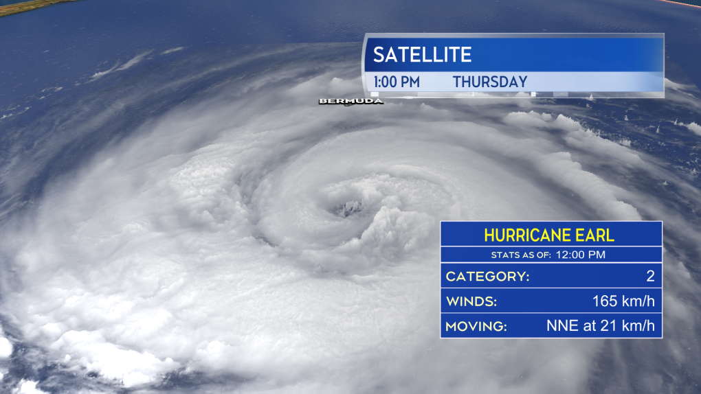 A high-resolution satellite image of Hurricane Earl positioned to the south of Bermuda Thursday afternoon.
While passing to the east of Bermuda, the island is expected to experience tropical storm conditions beginning Thursday afternoon and extending into the evening. That would include sustained winds near, or in excess, of 65 km/h and rain that could total 25 to 75 mm. A Tropical Storm Warning and Hurricane Watch are in effect for Bermuda.
Should Earl reach category three, it will be the first major hurricane (category three or higher) of the 2022 Atlantic Hurricane Season.
![]() The forecast track and intensity for Hurricane Earl over the next several days as issued by the National Hurricane Center.
The forecast track and intensity for Hurricane Earl over the next several days as issued by the National Hurricane Center.
While the forecast path of the hurricane holds well east of the land areas of Atlantic Canada, it may pass near or through the Grand Banks marine districts this weekend. Earl would be transitioning from a category three hurricane into a powerful post-tropical storm during this time.
There is only a low probability (less than 20 per cent) of eastern Newfoundland experiencing tropical storm force winds (63+ km/h) with hurricane force winds (120 km/h) remaining offshore.
The powerful weather system is expected to generate increased ocean swell and currents for coastal areas of Nova Scotia and Newfoundland this weekend and early next week. That may increase the risk of rip currents — something to be aware of if recreation or work takes you into the surf this weekend.
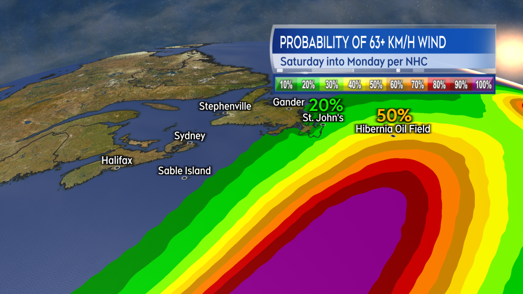 There is only a low probability being given of eastern Newfoundland experiencing tropical storm force wind this weekend and none for the Maritimes.
In 2010 a category one hurricane, also named Earl, made landfall near Western Head in Queens County Nova Scotia on Sept. 4 at 10 a.m. The storm impacted Nova Scotia and Prince Edward Island with power outages and some flash flooding. One fatality, a drowning, was attributed to the storm.
August was a quiet month for tropical storms and hurricanes in the Atlantic. A combination of wind shear, dry air, and Saharan dust dampening the start of any storms. It was the first August since 1997 not to have a single tropical storm or hurricane develop. The peak of the Atlantic hurricane season is September and October with the season closing at the end of November.
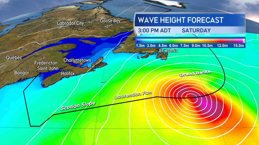 Coastal swell and currents are likely to increase for Nova Scotia and Newfoundland this weekend due to the passage of the storm to the east.
Shopping Trends
The Shopping Trends team is independent of the journalists at CTV News. We may earn a commission when you use our links to shop. Read about us.


CTVNews.ca Top Stories

Joe Biden pardons son Hunter Biden of gun, tax charges, despite promising not to
U.S. President Joe Biden announced Sunday that he pardoned his son Hunter Biden on gun, tax charges, despite previous promises that he would not do so.
Canada Post presents union with 'framework' to reach deal as strike continues
Canada Post has presented the union representing some 55,000 striking postal workers with a framework to reach negotiated agreements, the corporation said.
'Devastating': Missing Surrey, B.C. teen found dead, family says
The family of a missing 18-year-old, who was last seen in Surrey over a month ago, says there has been a tragic end to the search.
The best tips to prepare your car for the winter
Slippery or snow-covered roads, reduced visibility and bitter cold are all conditions that can make driving difficult and even dangerous during cold weather months. CAA spoke with CTV Morning Live this week on some of the best ways you can winterize your car.
PM Trudeau 'surprised' provinces unanimous on accelerated defence spending: Ford
Ontario Premier Doug Ford says his fellow provincial leaders are united in pushing for Canada to meet its NATO defence spending targets ahead of schedule, and that Prime Minister Justin Trudeau was "surprised" to hear it.
Stellantis CEO resigns as carmaker sales continue to slump
Stellantis CEO Carlos Tavares is stepping down after nearly four years in the top spot of the automaker, which owns car brands like Jeep, Citroën and Ram, amid an ongoing struggle with slumping sales.
'Wicked' star Marissa Bode speaks out against 'harmful' ableist comments made about her character
'Wicked' actress Marissa Bode posted a video on TikTok asking for kindness after receiving ableist comments on social media.
Poilievre calls for asylum seeker cap, border plan as U.S. tariff threat looms
Conservative Leader Pierre Poilievre has demanded the federal government present a plan before Parliament to beef up border security as U.S. president-elect Donald Trump threatens to impose stiff tariffs on Canada.
Emergency crews battle large fire at Kitchener, Ont. townhouse complex
Waterloo Regional Police say Kingsway Drive will remain closed as emergency crews continue to battle a large blaze at a townhouse complex.
Toronto
-

Man, 25, charged with murder after allegedly killing mother in Pickering: police
A 25-year-old man has been charged with second-degree murder after allegedly killing his mother on Sunday morning in Pickering, say police.
-
Toronto-based arts-grant provider says nearly $10M was stolen by 'cybercriminal intruder'
A Toronto-based non-profit that provides grants to musicians and others in the music industry says that nearly $10 million was stolen from its bank account by a 'cybercriminal' and then converted into cryptocurrency.
-
Why teens’ mental health may be more strained than you think heading into the holidays
While many people might think of the end of the year as a time to wind down one’s workload and take a break, a Toronto psychiatrist says young people may actually be carrying more stress than usual heading into the holiday season.
Calgary
-

No parking signs erected along street, home to RV residents
There is a development in the predicament of several people who live in RVs along a northeast Calgary street.
-
HIV rates in Alberta are up 73%, nearly doubled since 2019
Sunday marks World AIDs Day and doctors, researchers, and community advocates are raising the alarm over the significant rise in HIV rates across Canada, including Alberta.
-
Christmas tree supply improves, say lot workers
Many Christmas tree lots are open for business across Calgary, and workers say supply issues from a few years ago have abated.
Edmonton
-

Natural gas line severed by vehicle crash ignites fire at gas station east of Edmonton
The Tempo service station on the south side of Highway 16 at Range Road 223 burned down on Sunday after a vehicle crashed into the back of the building and severed a natural gas line.
-
HIV rates in Alberta are up 73%, nearly doubled since 2019
Sunday marks World AIDs Day and doctors, researchers, and community advocates are raising the alarm over the significant rise in HIV rates across Canada, including Alberta.
-
Edmonton mayor to pitch tax reduction plan for 'immediate relief'
Edmonton's mayor is pitching a plan to lower property taxes.
Montreal
-

Troubling allegations against Montreal's Bordeaux Prison over medical care for inmate battling cancer
An Indigenous man battling cancer, and his family are alleging that Montreal's Bordeaux Prison has failed to provide him with adequate medical care, claiming that it's now too late to stop the disease's progression.
-
HIV cases surge in Quebec, experts call for increased access to prevention and support
HIV cases in Quebec have increased compared to previous years. According to Institut national de santé publique du Québec (INSPQ), 917 cases of HIV were recorded in 2022.
-
Charlie McAvoy and Charlie Coyle each score twice as Bruins beat Canadiens on 100th anniversary
Charlie McAvoy scored two goals — one coming when Boston scored three times in 70 seconds during the opening period — and the Bruins celebrated the 100th anniversary of their first NHL game with a 6-3 victory over the Montreal Canadiens on Sunday.
Ottawa
-

Stittsville family recreates Christmas movie themed holiday light display for charity
A Christmas classic in Stittsville is back.
-
Canadian tech company helps children with disabilities walk for the first time
A Canadian tech company and an Ottawa pediatric care centre teamed up to offer kids with mobility challenges a once in a lifetime opportunity to take their very first steps.
-
Low rise building fire seriously injures 40-year-old in downtown Ottawa
A fire that started in the basement of a two-storey building in downtown Ottawa on Saturday night seriously injured a 40-year-old, paramedics say.
London
-

SIU investigating collision north of London that sent three to hospital
A collision occurred between two vehicles, and three people were transported to hospital, two with life-threatening injuries.
-
Canada Post presents union with 'framework' to reach deal as strike continues
Canada Post has presented the union representing some 55,000 striking postal workers with a framework to reach negotiated agreements, the corporation said.
-
Intense Ontario snow strands vehicles, knocks out power, and is heading south
Intense snow squalls battering Ontario moved south after burying some parts of the province under more than a metre of snow, stranding vehicles and prompting one town to declare a state of emergency.
Barrie
-

Muskoka reacts to major snowfall, Highway 11 still closed
From road closures, power outages, weather declarations and nonstop shoveling, Muskoka residents were faced with nearly a metre of persistent snowfall this weekend.
-
Snow closes portion of Highway 11
OPP have closed a segment of Highway 11 in South Muskoka due to unsafe driving conditions caused by weather.
-
Muskoka declares significant weather event
The District Municipality of Muskoka has declared a significant weather event in response to the snow that continues to fall in the region.
Northern Ontario
-

Saultites keep digging as the snow keeps falling
Snowfall in Sault Ste. Marie seemed to be delayed this year, but the cruel joke by Mother Nature saw a single dump make up for weeks of fall-like weather.
-
Canadian team told Trump's tariffs unavoidable right now, but solutions on the table in surprise Mar-a-Lago meeting
During a surprise dinner at Mar-a-Lago, representatives of the federal government were told U.S. tariffs from the incoming Donald Trump administration cannot be avoided in the immediate term, two government sources tell CTV News.
-
Man fined $10K for abandoning homemade barge in Lake Nipissing
A man from Lavigne, Ont., has been fined $10,000 for abandoning a homemade barge in Lake Nipissing.
Kitchener
-

Emergency crews battle large fire at Kitchener, Ont. townhouse complex
Waterloo Regional Police say Kingsway Drive will remain closed as emergency crews continue to battle a large blaze at a townhouse complex.
-
One man dead after shooting at Kitchener's 'A Better Tent City'
One man is dead after an afternoon shooting at 49 Ardelt Ave. in Kitchener.
-
One man arrested after robbery involving firearm in Kitchener
One man has been arrested after a firearm was brandished during a robbery in Kitchener Saturday evening.
Windsor
-

Car ends up in water-filled ditch in Chatham-Kent
On Saturday afternoon at roughly 5:30 p.m., Chatham-Kent Police say that they responded to a single vehicle collision on Queens Line near Drake Road.
-
Former WWE star to appear in Leamington for NCG Wrestling's final show of 2024
The Noble Champions Group is set to present its final event of the year on Dec. 7 at the Leamington Portuguese Community Club.
-
Three million grams of cereal collected to feed students in annual Cereal Box Challenge
The food collected will help support 33 breakfast and snack programs in the Greater Essex County District School Board.
Winnipeg
-

Winnipeg man charged after drugs, shotgun seized
A 32-year-old man has been charged with several weapon and drug-related offences by Winnipeg police.
-
New mural unveiled in Winnipeg's West End
A new mural that captures the heart and soul of the city’s South Valour community was unveiled Sunday afternoon.
-
Woman arrested in Skywalk after wielding knife, threatening security: police
A Winnipeg woman is facing several charges after police said she threatened security at the Millenium Library downtown.
Regina
-

Manz found guilty of one charge of sexual assault, acquitted on five others after 57 hours of deliberations
After being sequestered for more than 57 hours, a 12-person jury has found Regina chiropractor Ruben Manz guilty of one count of sexual assault.
-
Agribition 2024 wraps up in Regina
The 53rd Canadian Western Agribition wrapped up on Nov. 29, after an event-filled day.
-
Temperature records broken, tied following latest snowfall in Saskatchewan
Saskatchewan received yet more snow as winter continues to ramp up on the prairies. With the increased precipitation, communities have recorded dipping temperatures – with a handful breaking or tying longstanding records.
Saskatoon
-

Saskatoon priest accused of sexual assault says he meant to encourage young girl with hug and kiss
A Saskatoon priest accused of sexual assault says he meant to encourage and reassure a young girl when he hugged and kissed her during an encounter in 2023. He recounted the incident in his testimony at Saskatoon Provincial Court Friday.
-
City crews battle overnight snowfall in Saskatoon
The City of Saskatoon crews are plowing and grading high traffic roads following overnight snowfall in the city.
-
Sask. Indigenous storytelling lives on through award-winning radio play
For thousands of years, Indigenous peoples in North America have passed down stories and history through oral tradition. That age-old practice continues today with We Treaty People, a nine-part radio play series created by Burnt Thicket Theatre.
Vancouver
-

Rising sea levels threaten YVR with severe flooding, Senate report says
Rising sea levels could prove catastrophic for Vancouver International Airport, according to a new report from the Senate of Canada looking at the risks climate change poses to critical infrastructure across the country.
-
South Vancouver residents hand city red card over consultation for FIFA training site
A portion of a park in southeast Vancouver is slated to close for close to two years as one of two sites selected by the city for training facilities for visiting teams during the upcoming 2026 FIFA World Cup.
-
Neighbours who sheared tops of B.C. man's bamboo plants ordered to pay $1K in damages
A B.C. man whose neighbours lopped the tops off of four of his bamboo plants has been awarded $1,000 in damages by the province’s Civil Resolution Tribunal.
Vancouver Island
-

Woman 'waving a weapon' seriously injured during Vancouver Island arrest; IIO called in
B.C.’s police oversight agency has been called in to investigate after a woman on Vancouver Island suffered a serious injury while being arrested Friday.
-
Rising sea levels threaten YVR with severe flooding, Senate report says
Rising sea levels could prove catastrophic for Vancouver International Airport, according to a new report from the Senate of Canada looking at the risks climate change poses to critical infrastructure across the country.
-
Neighbours who sheared tops of B.C. man's bamboo plants ordered to pay $1K in damages
A B.C. man whose neighbours lopped the tops off of four of his bamboo plants has been awarded $1,000 in damages by the province’s Civil Resolution Tribunal.
Kelowna
-

Study of 2023 Okanagan wildfires recommends limiting development in high-risk areas
A study into the devastating wildfires that struck British Columbia's Okanagan region in 2023 has recommended that government and industry limit development in high-fire-risk areas.
-
Kelowna, B.C., to host the Memorial Cup in the spring of 2026
The Western Hockey League's Kelowna Rockets will host the Memorial Cup in the spring of 2026, the Canadian Hockey League said Wednesday.
-
545 vehicles impounded in 332 days: BC Highway Patrol pleads for drivers to slow down
Mounties with the BC Highway Patrol in Kelowna say they've impounded more than 545 vehicles for excessive speed and aggressive driving so far this year. That works out to more than 1.6 per day.


