Slick mix of snow and rain moves into the Maritimes Wednesday
 A dog out for a walk with its owner during a mix of rain and snow in Langford, B.C., Monday, Feb. 27, 2023. THE CANADIAN PRESS/Chad Hipolito
MAINE WINTER WEATHER ADVISORY
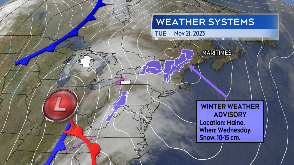 Winter weather advisories issued in the northeast U.S. ahead of a system that will bring the Maritimes a mix of snow and rain.
A weather system is getting a lot of attention in the United States because of the impacts to their very busy travel days leading up to Thanksgiving, but it will also have some impact in the Maritimes Wednesday into Thursday.
It’s a developing low-pressure system that will push to the eastern seaboard of the U.S. Wednesday morning before passing across the southwest of Nova Scotia Thursday morning. A winter weather advisory has already been issued by the U.S. National Weather Service for parts of Maine. The advisory is calling for potential snow of 10 to 15 cm on Wednesday, creating difficult travel conditions.
SNOW AND RAIN MIX
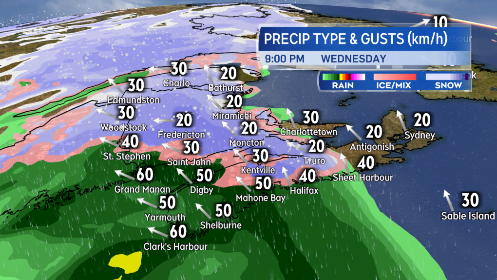 A mix of snow and rain develops west-to-east across the Maritimes late Wednesday morning through evening.
The Maritimes will also receive a mixture of snow and rain from the same system.
By noon on Wednesday, snow is expected to be falling across much of western New Brunswick, with rain approaching southwestern Nova Scotia. By the start of Wednesday evening, snow will be falling across most of New Brunswick, except mixed with rain south of Fredericton. Rain will be in place across the western half of mainland Nova Scotia. A wet and slushy snow is initially possible for northern areas of Nova Scotia, including parts of the Annapolis Valley, Cumberland, Colchester, and Pictou Counties. As temperatures rise Wednesday night into Thursday morning, the snow-rain line is expected to push all the way up into northern areas of New Brunswick.
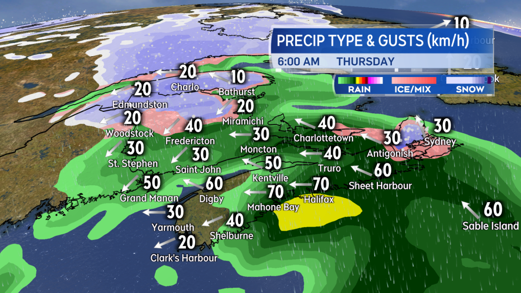 Temperatures rise Wednesday night into Thursday morning, transitioning most snow in the Maritimes over to rain and showers.
AMOUNTS AND WIND
Western areas of New Brunswick can expect the most snow from the system. Five to 15 cm is possible, except lower towards the Bay of Fundy coastline where the snow transitions to rain quicker. Snow amounts of 2 to 5 cm in eastern New Brunswick is possible before a turn to rain.
In Nova Scotia, parts of the Annapolis Valley, Cumberland, Colchester, and Pictou Counties could pick up a slushy 2 to 5 cm of snow before a turn to rain. The Cape Breton Highlands could pick up 5 to 10 cm of snow from the system. For other areas of the Maritimes, if there is some initial snow, the turn to rain is expected to limit accumulation.
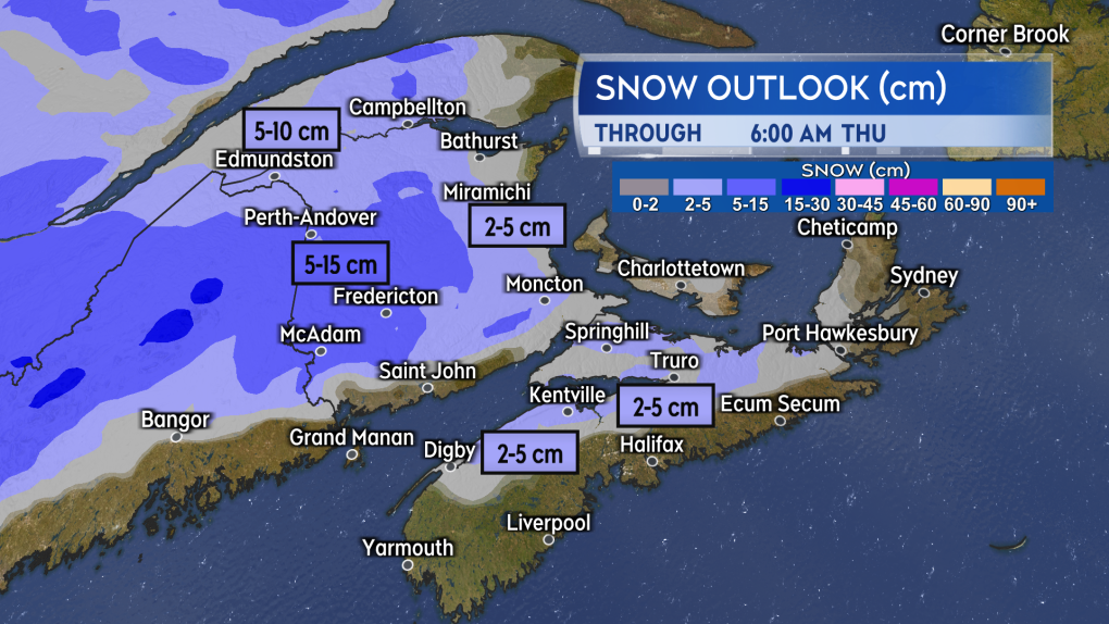 While a “wet” snow accumulation ranging up to a few to several centimetres is possible before a turn to rain, higher snow amounts approaching 10 or even 15 cm is possible for parts of western New Brunswick.
Speaking of the rain -- amounts of 30 to 50 mm are expected for the Atlantic coastal side of mainland Nova Scotia and across Cape Breton. The remainder of the Maritimes can expect rain amounts of less than 30 mm.
Wind will be gusty when some of the snow and rain comes through, but peak gusts look to be below 90 km/h, which is warning criteria. A southeast wind Wednesday will turn east Thursday night. The peak gusts for Nova Scotia and the Bay of Fundy coastline will range 40 to 70 km/h Wednesday night. The rest of the Maritimes will see gusts of 20 to 50 km/h.
Shopping Trends
The Shopping Trends team is independent of the journalists at CTV News. We may earn a commission when you use our links to shop. Read about us.


CTVNews.ca Top Stories

W5 Investigates
W5 Investigates A 'ticking time bomb': Inside Syria's toughest prison holding accused high-ranking ISIS members
In the last of a three-part investigation, W5's Avery Haines was given rare access to a Syrian prison, where thousands of accused high-ranking ISIS members are being held.
'Mayday!': New details emerge after Boeing plane makes emergency landing at Mirabel airport
New details suggest that there were communication issues between the pilots of a charter flight and the control tower at Montreal's Mirabel airport when a Boeing 737 made an emergency landing on Wednesday.
BREAKING
BREAKING Supreme Court affirms constitutionality of B.C. law on opioid health costs recovery
Canada's top court has affirmed the constitutionality of a law that would allow British Columbia to pursue a class-action lawsuit against opioid providers on behalf of other provinces, the territories and the federal government.
Cucumbers sold in Ontario, other provinces recalled over possible salmonella contamination
A U.S. company is recalling cucumbers sold in Ontario and other Canadian provinces due to possible salmonella contamination.
Irregular sleep patterns may raise risk of heart attack and stroke, study suggests
Sleeping and waking up at different times is associated with an increased risk of heart attack and stroke, even for people who get the recommended amount of sleep, according to new research.
Real GDP per capita declines for 6th consecutive quarter, household savings rise
Statistics Canada says the economy grew at an annualized pace of one per cent during the third quarter, in line with economists' expectations.
Nick Cannon says he's seeking help for narcissistic personality disorder
Nick Cannon has spoken out about his recent diagnosis of narcissistic personality disorder, saying 'I need help.'
California man who went missing for 25 years found after sister sees his picture in the news
It’s a Thanksgiving miracle for one California family after a man who went missing in 1999 was found 25 years later when his sister saw a photo of him in an online article, authorities said.
As Australia bans social media for children, Quebec is paying close attention
As Australia moves to ban social media for children under 16, Quebec is debating whether to follow suit.
Toronto
-

Black Friday sales stretch out for weeks: retail analyst
Black Friday is officially the busiest shopping day of the year, even surpassing Boxing Day and Super Saturday, the final Saturday before Christmas. Analysts say retailers are rolling out Black Friday sales sooner now, making them last longer into Cyber Monday and beyond.
-
Cucumbers sold in Ontario, other provinces recalled over possible salmonella contamination
A U.S. company is recalling cucumbers sold in Ontario and other Canadian provinces due to possible salmonella contamination.
-
House fire in North York sends 6 people to hospital
Six people are in hospital as a precaution after a fire broke out in a North York home overnight.
Calgary
-

Multiple crashes reported on Deerfoot Trail
Calgary police say there are at least three major crashes on Deerfoot Trail on Friday morning as frigid overnight temperatures likely led to icy conditions in many areas.
-
Black Friday deals look to appeal to budget-friendly Calgary shoppers
Black Friday sales are in full swing as annual holiday shopping returns and Calgary retailers are competing harder than ever to coax budget-conscious shoppers into a deal.
-
WEATHER
WEATHER Temperatures to rise more than 20 degrees in less than 2 days
A weather pattern with both persistent Arctic air and an ample supply of moisture have left Albertans with a much different weather story than they started the month with.
Edmonton
-

Oilers rightly optimistic they can pull themselves into NHL playoff picture. Again
Hockey fans know the adage: U.S. Thanksgiving, while unofficial, serves as a great calendar marker in predicting which teams will make the National Hockey League playoffs.
-
ATV driver killed in crash on Sturgeon Lake Cree Nation
A 31-year-old man was killed in a crash on Sturgeon Lake Cree Nation on Thursday.
-
WEATHER
WEATHER Josh Classen's forecast: A few more cold and snowy days, then the deep freeze breaks
We'll close out November with two more frigid days and Sunday doesn't look much warmer.
Montreal
-

'Mayday!': New details emerge after Boeing plane makes emergency landing at Mirabel airport
New details suggest that there were communication issues between the pilots of a charter flight and the control tower at Montreal's Mirabel airport when a Boeing 737 made an emergency landing on Wednesday.
-
As Australia bans social media for children, Quebec is paying close attention
As Australia moves to ban social media for children under 16, Quebec is debating whether to follow suit.
-
Some Quebec daycares to open at 10 a.m. due to worker strike
For the third week in a row, some 3,000 workers at daycares in Quebec are expected go on strike for a few hours.
Ottawa
-

'Dude, Where's My Bus?' Ottawa man fed up with OC Transpo makes documentary exploring transit troubles
Gio Petti put together a documentary on OC Transpo, asking how we got here. How did a city that was once lauded as an example of how to do transit right, and that boasted some of the highest per capita transit ridership numbers in the country, become a system that now elicits so much frustration from users?
-
Ottawa to begin full enforcement of 3-item garbage limit on Monday: Here’s what you need to know
The City of Ottawa will begin the final phase of the graduated approach to enforcing the city’s new three-item garbage limit on Monday, leaving behind any extra items not in a yellow bag.
-
Ottawa police charge two adults, teenager following Orleans kidnapping and robbery
The Ottawa Police Service says two adults and a teenager are facing multiple charges following a kidnapping, robbery and extortion incident that happened last month in Orleans.
London
-

Sarnia police lay charges after women wakes up to naked man in her home
An arrest has been made after a break and enter call in Sarnia where a woman woke up to a naked man in her home. Police said after investigating, officers were able to identify a 26-year-old man who was also wanted on an outstanding warrant in London.
-
Knights' Boulton hit with eight-game suspension
The left winger has been suspended eight games, retroactive to Nov. 23 against Saginaw, when he was handed a major penalty for slashing, along with a game misconduct.
-
'Shock, disappointment, and excitement': South Bruce not selected for nuclear waste project
Anja Vandervlies and Michelle Stein could hardly believe it when they heard South Bruce was not going to host Canada’s first permanent storage facility for nuclear waste.
Barrie
-

50 cms of snow across central Ontario expected this weekend
Environment Canada has released snow squall warnings and watches for our region.
-
Individuals living in encampment in Barrie's south end given notice to vacate
Several police officers and city staff attended a homeless encampment in Barrie’s south end on Thursday morning to inform the individuals living there they would have to vacate the area.
-
Man convicted of violent sexual assault of a senior could be deemed dangerous offender
The Crown wants a Wasaga Beach man to be deemed a dangerous or long-term offender following a violent sexual assault of a senior inside her Stayner home two years ago.
Northern Ontario
-

Another 50 cm of snow possible in the Sault as severe weather continues
Closures and cancellations are piling up in Sault Ste. Marie as a major winter storm continues for another day Friday.
-
Ongoing bed bug issue at a Timmins apartment building is 'like living in hell'
A battle with bed bugs continues at 217 Pine St. North in Timmins, according to a tenant who has lived there for a year and a half.
-
California man who went missing for 25 years found after sister sees his picture in the news
It’s a Thanksgiving miracle for one California family after a man who went missing in 1999 was found 25 years later when his sister saw a photo of him in an online article, authorities said.
Kitchener
-

One dead, another hurt in Cambridge shooting
Waterloo Regional Police are investigating a fatal shooting in Cambridge.
-
Police looking for missing teen last seen in Cambridge
Waterloo Regional Police are looking for information about the whereabouts of a missing teen.
-
Mother from Guelph, Ont. seeks answers following son's death in prison
Brody Robinson was found without vital signs in his cell at Millhaven Institution the evening of Oct. 29. He was 23-years-old.
Windsor
-

Judgment day: Windsor man to learn his fate in double fatal Retrofest collision
The Windsor man who is charged in connection to the death of two people is expected to hear his fate Friday.
-
Windsor man charged in child pornography investigation
A Windsor man has been charged following a child pornography investigation.
-
Injury reported at NextStar Energy plant work site
The Ministry of Labour is investigating after an injury at the construction site of the NextStar Energy battery plant.
Winnipeg
-

Hanover School Division laying off 93 EAs due to confusion over funding
The Hanover School Division is laying off 93 educational assistants, citing an "unexpected loss of federal funding for Jordan's Principle programming."
-
Possible water main break causing Friday morning traffic delays in Winnipeg
A potential water main break is causing traffic delays on Friday morning in Winnipeg.
-
A tale of two downtowns: Restaurants opening and closing show complexity of downtown revival
Proposed developments and new businesses opening are fueling optimism for some on a revival of downtown Winnipeg, but some business owners say the present remains problematic.
Regina
-

Crown gives final remarks in Ruben Manz case as argument to jury concludes
The prosecution has presented their closing remarks against Ruben Manz to a 13-person jury, bringing an end to arguments before their sequestering.
-
Youngest roping duo looking for repeat performance at Agribition Rodeo
Kavis Drake, 18, and Denim Ross, 20, won the average in last year’s Maple Leaf Finals Rodeo team roping event at Agribition. The two were the youngest competitors in 2023 and are once again in their event this year.
-
Canada Post temporarily laying off striking workers, union says
The union representing Canada Post workers says the Crown corporation has been laying off striking employees as the labour action by more than 55,000 workers approaches the two-week mark.
Saskatoon
-

Ontario men arrested after Saskatoon police seize 16 kilos of meth, nearly $70K in cash
Saskatoon police say officers arrested three 20-year-old men Wednesday afternoon and seized nearly $70,000, in cash as well as various illicit drugs.
-
Extreme cold warning issued for Saskatoon
Environment Canada has issued an extreme cold warning for parts of central Saskatchewan, including Saskatoon, on Thursday.
-
Sask. forecasting $743.5M deficit in mid-year financial report, up $470.5M from budget
The provincial government says increases to crop insurance claims later in the growing season are a main reason for Thursday’s mid-year deficit forecast of $743.5 million, which is up more than $470 million from the budget.
Vancouver
-

Surrey Police Service officially takes over from the RCMP after years-long saga
The years-long saga over who will police the city of Surrey has reached its final chapter.
-
BREAKING
BREAKING Supreme Court affirms constitutionality of B.C. law on opioid health costs recovery
Canada's top court has affirmed the constitutionality of a law that would allow British Columbia to pursue a class-action lawsuit against opioid providers on behalf of other provinces, the territories and the federal government.
-
Vancouver businesses told to prepare for Swiftie traffic: report
The Taylor Swift train is just a week away from stopping in Vancouver.
Vancouver Island
-
 BREAKING
BREAKING Supreme Court affirms constitutionality of B.C. law on opioid health costs recovery
Canada's top court has affirmed the constitutionality of a law that would allow British Columbia to pursue a class-action lawsuit against opioid providers on behalf of other provinces, the territories and the federal government.
-
Avian flu case discovered in Greater Victoria, officials confirm
The Canadian Food Inspection Agency (CFIA) has confirmed a case of avian flu has been detected in Greater Victoria, on the Saanich Peninsula.
-
Real GDP per capita declines for 6th consecutive quarter, household savings rise
Statistics Canada says the economy grew at an annualized pace of one per cent during the third quarter, in line with economists' expectations.
Kelowna
-

Kelowna, B.C., to host the Memorial Cup in the spring of 2026
The Western Hockey League's Kelowna Rockets will host the Memorial Cup in the spring of 2026, the Canadian Hockey League said Wednesday.
-
545 vehicles impounded in 332 days: BC Highway Patrol pleads for drivers to slow down
Mounties with the BC Highway Patrol in Kelowna say they've impounded more than 545 vehicles for excessive speed and aggressive driving so far this year. That works out to more than 1.6 per day.
-
Man in hospital following targeted shooting in Kamloops
Police are appealing for information on a targeted shooting that resulted in the hospitalization of a man in Kamloops.


